Showing 982 items
matching shillings
-
 National Wool Museum
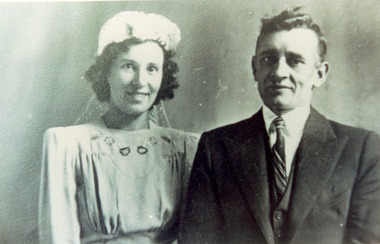
Photograph - Wedding Photo of Gladys Harris and Charles Allen, 1937
This photograph shows Charles Winnet Daniel Allen and Gladys Eileen Harris on their wedding day, 18th December 1937. This photographs relates to the fox fur coat which is now part of the National Wool Museum Collection, NWM-9090. "The foxes were shot in the 1950's by my Father, Charles Winnet Daniel Allen at two properties around Bacchus Marsh. One was Greystones at Glenmore, owned by the O'Keith family and the other was at Parwan, owned by the Miles Family. In the late 1940's and early 1950's, the Government put a bounty on the fox head. A pair of ears were sent to the Council and you were paid 2 pennies and the skins were sold to a skin buyer. My Father would go out on moon lit nights and shoot the foxes then skin them, which he would peg on a board to dry. He took 21 fox skins to Nettlebergs Pty. Ltd., Furriers at 173 Elizabeth Street Melbourne, Victoria, to have this coat made for my Mother, Gladys Eileen Allen. It cost Twenty Pound and Nine Shillings to have the skins made into this coat. My Father died on the 1st July 1982 and my Mother on the 15th October 1993, aged 76. This coat was inherited by me Theresa Joy Hodge (nee Allen) on the passing of my Mother. I have worn it on cold days, but seeing that I am 84 and the coat is 74 years old, I would like to donate it to you, as I have no-one to leave it to and hope that you and the visitors to your Museum will enjoy looking at it." Theresa Hodge, 2025 Theresa was a dairy farmer, who grew up in Bacchus Marsh with her parents, before moving to South Australia in 1980 to a 167 acre farm in Burrungale.Black and white photograph a man and a woman standing together. The woman is wearing a wedding gown and headpiece, and the man is wearing a suit.back: [handwritten] Wedding Photo of Gladys Harris / and Charles Allen 1937 / 17-3-1994 / 18-12-37 / Church of England / 18-12-1937 / ORIGINAL: / a. Surmon back: [printed] ALLEYNE HOCKLEY / 12 WILKIE STREET / CASTLEMAINE 3450 / Phone 721425 back: [printed] Kodak / PAPERfox fur coat, fashion, hunting, pest eradication, farming, rural life, bacchus marsh, greystones, glenmore, parwan, fox, nettlebergs pty ltd, furriers, clothing, theresa hodge, charles allen, gladys allen, wedding -
 National Wool Museum
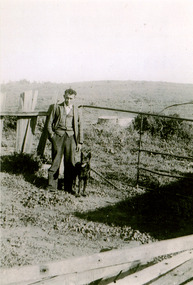
Photograph - Charles Winnet Daniel Allen, Bacchus Marsh, 1939
This photograph shows Theresa Joy Hodge's father Charles Winnet Daniel Allen on property in the Bacchus Marsh area, where he shot foxes which which were turned into a fox fur coat, which is now part of the National Wool Museum Collection, NWM-9090. "The foxes were shot in the 1950's by my Father, Charles Winnet Daniel Allen at two properties around Bacchus Marsh. One was Greystones at Glenmore, owned by the O'Keith family and the other was at Parwan, owned by the Miles Family. In the late 1940's and early 1950's, the Government put a bounty on the fox head. A pair of ears were sent to the Council and you were paid 2 pennies and the skins were sold to a skin buyer. My Father would go out on moon lit nights and shoot the foxes then skin them, which he would peg on a board to dry. He took 21 fox skins to Nettlebergs Pty. Ltd., Furriers at 173 Elizabeth Street Melbourne, Victoria, to have this coat made for my Mother, Gladys Eileen Allen. It cost Twenty Pound and Nine Shillings to have the skins made into this coat. My Father died on the 1st July 1982 and my Mother on the 15th October 1993, aged 76. This coat was inherited by me Theresa Joy Hodge (nee Allen) on the passing of my Mother. I have worn it on cold days, but seeing that I am 84 and the coat is 74 years old, I would like to donate it to you, as I have no-one to leave it to and hope that you and the visitors to your Museum will enjoy looking at it." Theresa Hodge, 2025 Theresa was a dairy farmer, who grew up in Bacchus Marsh with her parents, before moving to South Australia in 1980 to a 167 acre farm in Burrungale.Black and white photograph featuring a man standing on a rural property with a dog beside him. A gate, fencing and water tank are shown in the background.back: [handwritten] 1939 / Charles Winnet Daniel / Allen back: [printed] FUJIFILM / Fujicolour Crystal Archive / Paperfox fur coat, fashion, hunting, pest eradication, farming, rural life, bacchus marsh, greystones, glenmore, parwan, fox, nettlebergs pty ltd, furriers, clothing, theresa hodge, charles allen, gladys allen -
 Kiewa Valley Historical Society
Book - Ledger Commercial, "Ledger No. 4", Circa 1895
Historically this ledger not only details the legible hand writing of this era but also the day to day commercial activity in this region(first entry in 1895).The neatness and the diligence of those who were required to pen the information was a requirement by all who were in commercial trade. Emphasis on neatness was ingrained in students at a young age. This era was well before general typewriters and computers. Generally all students of commerce required an accuracy in writing and arithmetic. Neatness and order were a selection requirement. This ledger belonged to a general store, which was a forerunner to supermarkets and specialty stores. The shop provided everything from food, postage stamps, nails, tobacco, boots and Epsom salts. The general store provided nearly every product required to exist in a remote rural area of Australia in the 1800's.This item clearly identifies the Kiewa Valley as having a substantial financial hub to accommodate the various commercial enterprises within a rural environment Circa 1880's. Although Kiewa Valley had mining, agriculture, cattle and sheep it was also composed of a mixed society, encompassing all levels of society at that period. It identifies some the commercial activities(newsagency/general store) undertaken by specific families farming in the Kiewa Valley and relates their history in the pioneer period of the late 1800's. Some of those pioneers still have descendants living on the same home sites provided by the 1847 Land Act.This ledger has a very thick cover of strong compressed cardboard. Originally it had a cloth covering both front and back(Glued on) but due to wear and tear it is only attached to the back cover) and is a faded blue colour. The corners of the opening side of the cover are reinforced by suede cloth,in a triangular shape, and enclose both the front and inside portions of the the ledger. The spine is reinforced by a suede section to provide increased strength and protection. The inside cover (both front and back) has an orange bubbles with red and blue sinuous lines forming shapes in a haphazardous pattern. The grammage of the lined sheets (blue) is approximately 120g/m. Originally the first seven of twelve pages were indented and alphabetically marked with black letters (one letter per page) however this ledger had been modified to cover only the initials of customers and the pages of unused letters were glued to the previous page. The remaining pages are numbered in black print at the top outside edge of each page. There are 890 page numbers. Each page has thirty seven blue horizontal lines and one double red line ( top). Each page has thirteen vertical lines starting from the top horizontal double red lines and ending at the bottom of the page. These lines segregate the page into blocks for the date, the transaction and financial input. There are three double vertical red lines which designate the amount of money of each transaction (in pounds, shillings,and pence).On the suede spine in gold lettering and on a red (port coloured) background "LEDGER"grocery shop, haberdashery, general store -
 Mont De Lancey
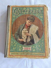
Book, Wells Gardner, Darton & Co. Limited, Chatterbox, 1894
A vintage 1894 Chatterbox collection of puzzles, poetry and stories for children with black lined illustrations and coloured plates throughout.A vintage 1894 hardcover children's book with the title Chatterbox printed in white lettering at the top of the front cover which has a green coloured background with an illustration in a large circle showing a boy sitting on a step near a door holding a white dog on his knee. The boy is wearing a green overcoat, brown tartan cap, red cravat and a brown jacket. He has a white blanket across his left shoulder. The publisher details are printed at the bottom, with Price Three Shillings printed in black letters at the very top. Green tape covers the spine, holding the covers together. The covers are damaged and faded. The faded yellow coloured back cover has four advertisements: "Cadbury's", Symington's Pea flour and soup. Symington's Egyptian Food and 'Pears' soap.The manufacturer details are included for all. The frontispiece coloured illustration inside depicts a group of schoolboys near a red letterbox throwing snowballs at each other outside their school. A dog is watching. The title of the picture is 'A hard fought battle'. The title page has the title plus Founded by J. Erskine Clarke, M.A and publisher details with a black lined illustration of children, a woman with children at her knee reading and flowers. There are further coloured plates in the collection. The book contains plenty of puzzles, poetry, and stories for children. Pp. 412. At the back is an added supplement of Wells, Gardner, Darton & Co's Popular Books for prizes and presents. Pp.32.fictionA vintage 1894 Chatterbox collection of puzzles, poetry and stories for children with black lined illustrations and coloured plates throughout. children's books, books, children's stories, adventure stories -
 Dandenong/Cranbourne RSL Sub Branch
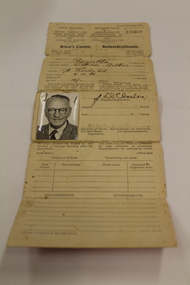
Durban South Africa Drivers Licence
It appears that Mr WA Benville was born in/near Durban South Africa on 6th Oct 1884. He served for Her Majesties Services for 222 days in the Boer war then came to Australia. He worked as Electrician at the GPO and lived at 180 High St.Kilda and joined the Australian Imperial Force, Australian flying Corps on 26/6/1917. Service No, 2320. Rank,.Air Mechanic 2nd Class. Roll Title Flying Corps Conflict Operation, First World War 1914-1918. Mr Benville Departed Melbourne on HMAT Port Sydney A15 on 9/11/1917. He was Married to Mrs Emily Madge Benville when he enlisted in Australia. Mrs Benville died on 10th July 1947. ( Buried at the Cheltenham Cemetery) Mr William Arthur Benville Died on 28th August 1976. Rest In Peace. Drivers licence to drive a Motor Car "William Arthur Benville" Natal Province District of Durban South Africa. Pink Cover.(The licence is written in English on left and Afrikaans on right. [We have used the English Inscriptions] Natal Province-Motor Vehicle and Road Traffic Regulation Ordinance 1937. (Ordinance No. 10 of 1937 as amended) Drivers Licence class of motor vehicle in which respect licence is granted Motor Car. 123659. Issued to Surname Benville, Christian Name William Arthur, Address 178 Florida Rd, Date of Birth 6.10.84, Fee Paid 10/- shillings This licence is hereby granted to the abovenamed person, whose photograph and signature (or right thumb impression) appear hereunder, to drive a motor vehicle of the class described above. (Signature) ?????? Registrar District DURBAN , Date 26Sep 1951 ( Line undecipherable ) he must present his licence at any revenue or borough licencing office for amendment. Change of Address Date New Address Recorded by. Endorsements PN 363-P. 15593/NW.756/4,000/22-6-49 -
 Flagstaff Hill Maritime Museum and Village
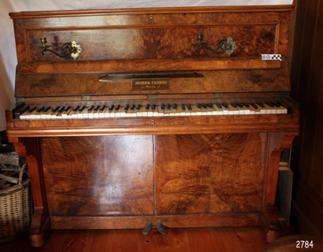
Instrument - Musical, Piano, Aucher Freres, circa 1880-1920
This piano was made by Aucher Freres of Paris, said to be famous for its pianos in the mid-late 1800s. Aucher Freres (Aucher Brothers) produced a model of piano that was built specifically for use on sailing vessels, the upright yacht-style piano. Pianos were amongst the domestic goods brought to Australia by many colonial immigrants. They were also imported by Australian distributors by the shipload and sought after by settlers. A piano was often found in a Missions to Seamen club room, where visiting seafarers would entertain or be entertained by music and song as part of their relaxation in port. A sarcastically written news article of January 2nd 1869 reported that the Secretary of the Loyal Liberals of Ballarat, Mr Henry Bell, was presented both with a “illuminated address” and a piano. The piano was made by Aucher Freres of Paris and was purchased for sixty guineas (which converts to around $7,500 Au in 2019). The gift was criticised for encouraging foreign industry rather than native Australian products, thus going against what the Loyal Liberals own protectionist policy. The writer goes on to state that several pianos made in the Colony compared very favourably at the International Exhibition with those manufactured by the English or French. He then says that “… the secretary … might learn a lesson from his piano ... the name Aucher Freres, Paris emblazoned on its front should be … a perpetual reminder of the hollowness of that protectionist imposture …” [Refer to Intercolonial News, Victoria, originally published in The Argus, was repeated in the Wallaroo Times and Mining Journal of South Australia 2-1-1869.] Aucher Freres pianos were still around in 1930. A second-hand model was advertised for sale as a good practice piano. The advertisement was placed by the Mount Gambier, SA, agents for Saver’s Pianos Ltd of Adelaide. The piano was described as “a sound little instrument of good tone and appearance”. The asking price in November 1930 was 32 pounds and ten shillings (which converts to about $2,500 Au in 2019). [Refer to Savery’s advertisement, Mt Gambier Border Watch 11-11-1930]This piano is significant for its connection with the time period of chapel and club room at Flagstaff Hill's St Nicholas Seamen's Church. It represents the form of entertainment enjoyed by seafarer's world wide, which is appropriate for a maritime village. The maker of the piano is famous for its quality pianos of the 19th and early 20th century.Piano, upright, polished wood. The wooden hinged keyboard cover lifts up to allow access to the keyboard. The piano also has two brass candlesticks. The top of the piano is hinged and lifts up to allow access to the piano mechanic's inside for tuning and maintenance. The inside flap has a music stand incorporated into it. It also has the usual two hard-soft pedals at the base. There are two brass decorated hooks at each end to allow for ease of movement when the position of the piano is changed. Maker's name inscribed inside keyboard lid in gold lettering. Made in Paris by Aucher Freres (Aucher Brothers)."AUCHER FRERES / Paris" (NOTE: the "C" is sometimes mistaken for a "G")flagstaff hill, warrnambool, shipwrecked-coast, flagstaff-hill, flagstaff-hill-maritime-museum, maritime-museum, shipwreck-coast, flagstaff-hill-maritime-village, piano, music, upright piano, paris, france, aucher freres -
 Tarnagulla History Archive
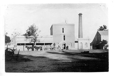
Photograph of Flour Mill complex, Tarnagulla, Flour Mill complex, Tarnagulla, circa 1882-1920
Murray Comrie Collection. Information written by Murray Comrie: A meeting was called at the Golden Age Hotel on 11th June 1868 when it was resolved to build a flour mill. Thomas Comrie was the proprietor and was responsible for the Mill being built. Tenders were called by H.C. Bristol, in the Tarnagulla Courier of January 10, 1874, for the erection of the mill. Building of the Mill commenced in 1874. Pipes were laid to Company's Dam to obtain water for the Mill's boilers. Steam was got up for the first time on 30th March, 1882. A boiler burst about April 29th. Two men (J.H. Smith and W. Hargreaves) died as a result and two others were seriously injured. The mill commenced operations on 13th June 1882 with Mr. W. Fitzgerald as manager. The Mill operated with grinding stones until 1899 when new rollers and a considerable amount of new equipment was installed, including a new, more powerful engine to drive the Mill. In January 1901, 6,000 bags of wheat were received weekly and it was a common sight to see the streets lined with wagons. In 1913, 15,000 bags of wheat were bought at three shillings and four pence per bushell. In January 1914, wheat came in at the rate of 1500 bags a day with 20,000 bags in storage. Thomas Comrie died on 4th August 1910. The Mill was carried on by his executors, then closed for a short period prior to being sold in September 1918 to a Mr. O. Albert of Talbot. Albert operated the Mill for a few years but during the 1920s it was closed down and then pulled down. It was later re-erected at Mildura where it operated for many years. The far left section of the complex was originally John Pierce's Southern Cross General Store, a wholesale grocer and spirit merchant. It was put up for sale after Pierce's death in 1871, and later incorporated into the Mill complex. This is a poor copy of an older original. Copy probably made by Murray Comrie in the 1960s. Monochrome photograph of men, horses and a wagon outside the Flour Mill complex formerly situated on the south east corner of King Street and Commercial Road in Tarnagulla. At far left the Methodist church is partially visible in the background. At far right is part of the Mill's storage shed. Same image as THA-2019.0211Written on reverse: 'M. Comrie'tarnagulla, commerce, agriculture, food production, mill, milling, horses, transport, buildings, commercial road, main street -
 Tarnagulla History Archive
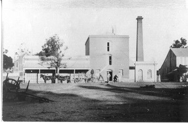
Photograph of Flour Mill complex, Tarnagulla, Flour Mill complex, Tarnagulla, circa 1882-1920
Murray Comrie Collection. Information written by Murray Comrie: A meeting was called at the Golden Age Hotel on 11th June 1868 when it was resolved to build a flour mill. Thomas Comrie was the proprietor and was responsible for the Mill being built. Tenders were called by H.C. Bristol, in the Tarnagulla Courier of January 10, 1874, for the erection of the mill. Building of the Mill commenced in 1874. Pipes were laid to Company's Dam to obtain water for the Mill's boilers. Steam was got up for the first time on 30th March, 1882. A boiler burst about April 29th. Two men (J.H. Smith and W. Hargreaves) died as a result and two others were seriously injured. The mill commenced operations on 13th June 1882 with Mr. W. Fitzgerald as manager. The Mill operated with grinding stones until 1899 when new rollers and a considerable amount of new equipment was installed, including a new, more powerful engine to drive the Mill. In January 1901, 6,000 bags of wheat were received weekly and it was a common sight to see the streets lined with wagons. In 1913, 15,000 bags of wheat were bought at three shillings and four pence per bushell. In January 1914, wheat came in at the rate of 1500 bags a day with 20,000 bags in storage. Thomas Comrie died on 4th August 1910. The Mill was carried on by his executors, then closed for a short period prior to being sold in September 1918 to a Mr. O. Albert of Talbot. Albert operated the Mill for a few years but during the 1920s it was closed down and then pulled down. It was later re-erected at Mildura where it operated for many years. The far left section of the complex was originally John Pierce's Southern Cross General Store, a wholesale grocer and spirit merchant. It was put up for sale after Pierce's death in 1871, and later incorporated into the Mill complex. This is a reasonable copy of an older original. Copy probably made by Murray Comrie in the 1960s. Monochrome photograph of men, horses and a wagon outside the Flour Mill complex formerly situated on the south east corner of King Street and Commercial Road in Tarnagulla. At far left the Methodist church is partially visible in the background. At far right is part of the Mill's storage shed. Same image as THA-2019.0048Written on reverse: 'M. Comrie'tarnagulla, commerce, agriculture, food production, mill, milling, horses, transport, buildings, commercial road, main street -
 Melbourne Legacy
Photograph, Hibernian Hall, 30/6/1947
A photo of the first property owned by Legacy, at 342 Swanston Street. After receiving money in memory of David H Dureau to purchase premises, Legacy purchased the old Hibernian Hall. However there were many issues with the property, including its suitability and the inability to gain vacant possession from the existing tenants. So eventually the property was sold and the money used to buy the current Legacy House, still formally known as the David H Dureau Memorial Building as per the bequest instructions. The notes on the back of the photo say it was sold to Sir Bernard Evans and then to RMIT and it was renamed Storey Hall. The full story of the donation has been pieced together from several sources. Part of the story of the donation towards Dureau House. BG Corporation in New York used 'Brown and Dureau' as agents in Melbourne for their spark plug manufacturing (for the American aircraft based in Australia during the war). A royalty of two shillings and sixpence was agreed. The entrepreneur President of BG Corporation was Richard Goldsmith. L/ Grat Grattan had a friend Mr Edwards who was managing director at Brown and Dureau and heard of the desire by Mr Goldsmith to leave a permanent memorial to ex-servicemen in Australia (Children's Hospital was considered). L/ Grattan took Mr Edwards to Market St (where Legacy was situated at the time) and showed him the inadequacy of the building. It was agreed if Melbourne Legacy could come up with a purchased building in 10 days they would get the money needed and the building was to be named in memory of David H Dureau, who had died at sea during the war. The donation was £27,059. The property purchased was 'Hibernian Hall' in Swanston St (later called Storey Hall when it was acquired by RMIT). After the war it turned out not to be suitable and a new building was required. An act of parliament was required to enable the sale (01262) and consent from the donor was also sought before the sale (document still to be catalogued). Money raised from the sale was used to purchase 293 Swanston St.A photo of the first property purchased by Legacy as a result of a generous donation.Black and white photo of the old Hibernian Hall in Swanston Street.Handwritten on back 'The old Hibernian Hall purchased by Melbourne Legacy and later sold because of inability to secure vacant possession from tenants. Sold to Sir Bernard Evans then to RMIT and named 'Storey House', in pencil. Stamped '30 Jun 1947' in purple inkproperties, dureau house, swanston st -
 Bendigo Historical Society Inc.
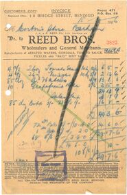
Financial record - INVOICE COLLECTION: Reed Bros
10934.28a - Receipt 3823 Receipt dated: 11 July 1939. Cream, rectangular paper The receipt header reads "Reed Bros." in large, bold capital letters. The Reed Bro's were wholesalers and general merchants, manufacturing aerated waters, cordials, tonics, sauces, vinegar, and pickles. below the company name, it lists the company's: Address - 10 Bridge Street, Bendigo. Contact Info - Phone 471, P.O. Box 66. There is a prominent diagonal black line through the page indicating that the receipt had been paid. Handwritten in blue pencil. The receipt indicates the purchase of tomato sauce, vinegar, water and additional items. Purchased for the amount of 29 pounds, 7 shillings and 6 pence. 10934.28b - Receipt 2606 Receipt dated: 15 Jan 1946. Cream, rectangular paper The receipt header reads "Reed Bros." in large, bold capital letters. The Reed Bro's were wholesalers and general merchants, manufacturing aerated waters, cordials, tonics, sauces, vinegar, and pickles. below the company name, it lists the company's: Address - 10 Bridge Street, Bendigo. Contact Info - Phone 471, P.O. Box 66. There is a prominent black X through the page indicating that the receipt had been paid. Handwritten in blue pencil. The receipt indicates the purchase freight shipping. 10934.28c - Receipt 1006 Receipt dated: 16 Nov 1945. Cream, rectangular paper The receipt header reads "Reed Bros." in large, bold capital letters. The Reed Bro's were wholesalers and general merchants, manufacturing aerated waters, cordials, tonics, sauces, vinegar, and pickles. below the company name, it lists the company's: Address - 10 Bridge Street, Bendigo. Contact Info - Phone 471, P.O. Box 66. There is a prominent diagonal green X through the page indicating that the receipt had been paid. Handwritten in blue pencil. The receipt indicates the purchase of vinegar and other items, including delivery. Purchased for the amount of 8 pounds and 8 pence. 10934.28d - Receipt 23588 Receipt dated: 21 Jan 1948. Cream, rectangular paper The receipt header reads "Reed Bros." in large, bold capital letters. The Reed Bro's were wholesalers and general merchants, manufacturing aerated waters, cordials, tonics, sauces, vinegar, and pickles. below the company name, it lists the company's: Address - 10 Bridge Street, Bendigo. Contact Info - Phone 471, P.O. Box 66. There is a prominent diagonal black line through the page indicating that the receipt had been paid. Handwritten in blue pencil. The receipt indicates the purchase of water, tomato sauce, vinegar and other items. Purchased for the amount of 57 pounds, 7 shillings and 10 pence. 10934.28e - Receipt 1152 Receipt dated: 26 Nov 1945. Cream, rectangular paper The receipt header reads "Reed Bros." in large, bold capital letters. The Reed Bro's were wholesalers and general merchants, manufacturing aerated waters, cordials, tonics, sauces, vinegar, and pickles. below the company name, it lists the company's: Address - 10 Bridge Street, Bendigo. Contact Info - Phone 471, P.O. Box 66. There is a prominent black X through the page indicating that the receipt had been paid. Handwritten in blue pencil. The receipt indicates the purchase of vinegar and freight delivery. 10934.28f - Receipt 0548 Receipt dated: 19Nov 1945. Cream, rectangular paper The receipt header reads "Reed Bros." in large, bold capital letters. The Reed Bro's were wholesalers and general merchants, manufacturing aerated waters, cordials, tonics, sauces, vinegar, and pickles. below the company name, it lists the company's: Address - 10 Bridge Street, Bendigo. Contact Info - Phone 471, P.O. Box 66. There is a prominent black X through the page indicating that the receipt had been paid. Handwritten in blue pencil. 10934.28g - Receipt 24769 Receipt dated: 9 Nov 1945. Green, square shaped paper. The receipt header reads "Reed Bros." in large, bold capital letters. The Reed Bro's were wholesalers and general merchants, manufacturing aerated waters, cordials, tonics, sauces, vinegar, and pickles. below the company name, it lists the company's: Address - 10 Bridge Street, Bendigo. Contact Info - Phone 471, P.O. Box 66. There is a prominent green X through the page indicating that the receipt had been paid. Purchase details stamped in black and red ink. The receipt indicates the purchase of tomato sauce, additional items. Including delivery. Purchased for the amount of 9 pounds, 5 shillings and 4 pence. 10934.28h - Receipt 13628 Receipt dated: 19 Sep 1941 Green, square shaped paper. The receipt header reads "Reed Bros." in large, bold capital letters. The Reed Bro's were wholesalers and general merchants, manufacturing aerated waters, cordials, tonics, sauces, vinegar, and pickles. below the company name, it lists the company's: Address - 10 Bridge Street, Bendigo. Contact Info - Phone 471, P.O. Box 66. There is a prominent Blue X through the page indicating that the receipt had been paid. Purchase details stamped in black and red ink. Additional notes written in grey lead pencil. The receipt indicates the purchase of tomato sauce, apple sauce, vinegar and additional items. Purchased for the amount of 13 pounds, 12 shillings and 3 pence. 10934.28i - Receipt 13217 Receipt dated: 15 July 1941. Green, square shaped paper. The receipt header reads "Reed Bros." in large, bold capital letters. The Reed Bro's were wholesalers and general merchants, manufacturing aerated waters, cordials, tonics, sauces, vinegar, and pickles. below the company name, it lists the company's: Address - 10 Bridge Street, Bendigo. Contact Info - Phone 471, P.O. Box 66. There is a prominent blue X through the page indicating that the receipt had been paid. Purchase details stamped in black and red ink. The receipt indicates the purchase of banana and peanut spreads. Including delivery. bendigo, morton's stores, reed bros. -
 Bendigo Historical Society Inc.
Magazine - AILEEN AND JOHN ELLISON COLLECTION: THE NEW NATION MAGAZINE
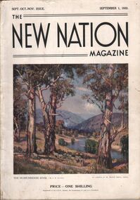
The New Nation Magazine Sept. Oct. Nov. Issue. September 1, 1932. On the front cover a painting "The Murrumbidgee River by J. R. Jackson. Price 1 shilling the magazine has 112 pages, the last two pages are ripped and the back cover is missing. Contents: Frontispiece "morning of the dogger bank" (by T. Benetter)- The British commonwealth of Nations - Switzerland, land of lakes and mountains (by Hilary lofting) - Highways of the Syrian desert (by Francis Birtles) - Seven ages of the Australian aboriginal - The game of the empire, the approaching cricket test matches (by M. A. Noble) - Short story, the last run (by H. H. Cardinal) - "The hidden bird" (by E. M. England) - North Australia trails ( by C. Price Conigrave) - Tales of the turf Fred Archer (by S. A. Marden) - The wide world round - Cape Horn (by J. Newman Barker) - "The home in the clearing" (by Sydney long) - Whitsunday passage (by Henry G. Lamond) - Old bridges (by J. L. Ranken) - The city of the longest drink (by A. C. Cummins) - The life of the cuckoo (by M. S.) - Radio - The world of music (by A. L. Kelly) - The world of women (by E. G. Manby Suttor) - Shopping from an easy chair - The Australian wool trade - Our verse farm - My wool clip (by H. W. Wright) - Windjammer days (by Gerald M. Moody) - Quarterly review of the stock and meat industry (by J. B. Cramsie) - New Zealand letter - At ye booksellers today - A number of things - The modern home - Portland cement - The good housewife (by E. G. Manby Suttor) - Cousin Shirley.book, magazine, the new nation -
 Bendigo Historical Society Inc.
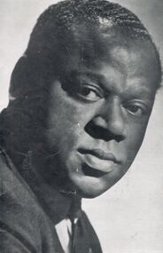
Document - WILLIAM WARFIELD AND OTTO HERZ PROGRAMME
William Warfield, Town Hall, Bendigo. Monday, 11th August 1958, 8.15 pm. The Australian Broadcasting Commission has pleasure in presenting the Third Concert in the International Celebrity Concert Series. Programme One Shilling. Article including photograph 'William Warfield' William Warfield made a great impression when he first toured Australia in 1950 Immediately following a sensational New York debut. He has since . . . Article including photograph 'Otto Herz' Otto Herz is a Hungarian-American pianist, accompanist, coach, teacher, and music school executive. He has studied piano with Karel Hoffmeister, at Prague and with Alfred Hoehn at Frankfurt. Dr Herz was a Professor at the Fodor Music Conservatory in Budapest, 1933-1938. . . Programme. Australian Broadcasting Commission, Sir Richard Boyer, K.B.E., M.A., Chairman. E R Dawes, ESQ., C.M.G., Vice-Chairman. Sir John Medley, KT., D.C.L., M.A. The Hon. Dame Enid Lyons, G.B.E. Mrs. G.L. Blyth, O.B.E., B.A. A G Lowndes, M.Sc., H B Halvorsen, F.C.A. (Aust.) Charles Moses, C.B.E. General Manager, Ewart Chapple Manager for Victoria. Ray Humphrey Concert Manager for Victoria. Advertisements: Shell, Orlando (Wine, Barossa Valley), Phillips, Daniel Barenboim, concert at Bendigo Town Hall, 1 Oct 1958), William Warfield Coronet Records. Front cover has photo of Wiliam Warfield, full size of page.entertainment, concert, vocalists -
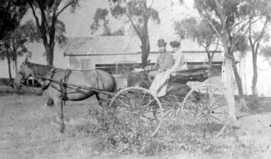 Surrey Hills Historical Society Collection
Photograph, 'Hillsboro' or "Hillsborough' - 6a Thistle Street, Surrey Hills, pre-1890
The photo was found behind a mantelpiece in the house at 6A Thistle Street while it was being renovated. It is thought to be of the first owner, Mrs Rachel Sweetnam (nee Lewis) and her husband, Thomas Edward Sweetnam. They were married on 24 September 1884 at St John's Church, Camberwell. REF: THE ARGUS 4 Oct 1884 Thomas second eldest surviving son of Matthew Sweetnam married to Rachel (Ray) third eldest daughter of Captain T.D. Lewis, Culm Haven, Camberwell. Thomas was active in land sales and variously described as a land agent, real estate agent and auctioneer. The property - Hillsboro or Hillsborough - was originally a house on a farm of 10 acres owned by her. It became 6A Thistle Street. According to the Alan Holt property register Rachel Sweetnam owned the property prior to 1890 and a family tree on Ancestry.com has that it was owned by her in c1886. It is likely that it was an investment rather than a family residence. Thomas Sweetnam was President of the Boroondara Shire 1888/89 and a councillor from 1886-1891. During his time as Shire councillor in 1887 he was charged with assaulting Charles A. Chandler, a window blind manufacturer, in response to an ‘insulting note’ left at Sweetnam’s house. Sweetnam was fined two guineas and 31 shillings. Sweetnam was also President of the Camberwell Gun Club from around 1890 – 91. In 1893 he relocated to Ferntree Gully, where he contested for the municipality’s North Riding council seat. Multiple references can be found on Trove. Note that the gentleman in this photo does bear a resemblance to Thomas Sweetman, President of Boroondara Shire in 1888-1889 found in the City of Boroondara Library Service mayoral portrait collection. No known photo of Rachel Sweetnam. Other property owners or residents are: 1890 Selina Gaylor 1900 Stephen Pullen 1910 William Murray (draftsman) 1920 George C Hughes 1930 Arthur Leslie Austin (tram driver) 1980 Mrs Lillian Evelyn Austin Sold in 1983 for $87,000. The house is still extant (January 2025). Note that we also have material / photos regarding George Hughes and family.This photo is one of the earliest photos of residences of Surrey Hills.Black and white photo of a woman and man in a buggy behind which is a simple house with a verandah at one end, surrounded by eucalypt trees.hillsboro, house names, thistle street, horse-drawn vehicle, clothing and dress, hillsborough, rachel sweetnam, rachel lewis, thomas sweetnam, selina gaylor, stephen pullen, william murray, george hughes, arthur austin, lillian austin -
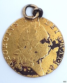 Flagstaff Hill Maritime Museum and Village
Currency - Guinea Coin, The Royal Mint, 1793 George III Spade Guinea, 1793
The coin was discovered by Julie Wilkins, a Victorian scuba diver who had already experienced more than 500 dives in Australia and overseas. She was holidaying in Peterborough, Victoria, and looking forward to discovering more about the famous Loch Ard ship, wrecked in June 1878 at Mutton Bird Island. The fast Glasgow-built clipper ship was only five years old when the tragedy occurred. There were 54 people on board the vessel and only two survived Julie's holiday photograph of Boat Bay reminds her of her most memorable dive. Submerged in the calm, flat sea, she was carefully scanning around the remains of the old wreck when, to her amazement, a gold coin and a small gold cross suddenly came up towards her. She excitedly cupped them in her hands, then stowed the treasures safely in her wetsuit and continued her dive. She soon discovered a group of brass carriage clock parts and some bottles of champagne. It was a day full of surprises. The items were easily recognisable, without any build-up of encrustations or concretion. Julie secretly enjoyed her treasures for twenty-four years then packed them up for the early morning train trip to Warrnambool. After a short walk to Flagstaff Hill Maritime Museum and Village, her photograph was taken as she handed over her precious find. She told her story to a local newspaper reporter, lunched a café in town then took the late afternoon train home. Her generous donation is now part of a vast collection of Loch Ard shipwreck artefacts, including the gold watch and the Minton Majolica model peacock. The coin is a British 1793 George III Gold Spade Guinea. It was already 83 years old when the Loch Ard had set sail. The loop and ring have been added, perhaps as a pendant, pocket watch accessory or similar purpose. It may have been worn for ‘good luck’ on the long journey to Australia, where ships had to carefully navigate the treacherous Bass’s Strait before arriving at their destination of Melbourne. Sadly, many met their fate on that short stretch of ocean aptly named the Shipwreck Coast. The coin is very recognisable even though it was exposed to the wrecking of the ship, its consequent movement, and the sea's turbulence. Its bent, scratched, buckled, split, dinted and worn condition is part of its story. The red-brown-black discolouration is similar to that found on other gold coins, sometimes called the ‘corrosion phenomena’. Studies suggest the possible cause is contaminants in the minting process reacting to the coins’ environment. The GEORGE III GOLD SPADE GUINEA: - The British Guinea was introduced in 1663 and was circulated until 1814. It was made of 22 carat gold, was 25 to 26 cm in diameter and weighed 8.35 grams. It had a value of 21 British shillings. The guinea coin ceased circulation after 1816 and was replaced by the one-pound note. However, the term ‘guinea’ continued to represent 21 shillings. King George (1738-1820) had six gold guinea designs minted during his reign from 1760 and 1820. Each of the six had different obverse portraits, all facing the right. There were three different reverse sides. The Spade Guinea was the fifth issue of the coin, introduced in 1787 and produced until 1799. The reverse shows a royal crown over a flat-topped shield with the Royal Arms of Great Britain, used in Scotland between 1714 and 1800. The shield images are, from left to right, top to bottom, the Arms of England and Scotland, the Arms of France, the Arms of Ireland, and the Arms of the House of Hanover. The Gold Guinea is also part of Australia’s history. It was the first coin mentioned in the announcement of Governor King of New South Wales his Australian Proclamation of a limited variety and denomination of coins accepted for use in the Australian Colony. The historic and decorative George III Spade Guinea has been reproduced for special collections of coins. However, replicas and imitations have also been made as souvenirs for tourists, as gaming tokens and chips for gamblers, and as ‘fake’ coins for profit. These coins differ in many ways; they may be only half the weight of the genuine coin. Often have a small stamp on the obverse with “COPY” or the manufacturer’s name or initials. Some have scalloped edges, some have dates that are different to the original dates of issue, and some even have text in Latin that translates as something very different to the original coin.The King George III Guinea was only produced from 1663 to 1814 and was the first English coin to be mechanically minted. The coin is the fifth edition of the King George III Guinea, the Spade Guinea, was only produced between 1787 and 1799. It is the only edition with this portrait of King George and the only one with the Royal Coat of Arms of Great Britain in Scotland on the reverse side. This edition was also the last guinea in circulation, because the sixth edition was reserved as the Military guinea. This edition of the Guinea is unique; This coin is the only guinea in our collection. It was minted in 1793, so it is now over 230 years old. The Gold Guinea is part of Australia’s history; it was the first coin in the list of coins for use in the Australian Colonies, mentioned by Governor King of New South Wales in his Australian Proclamation speech of 1800. The George III Spade Guinea was included in the Limited Edition Sherwood 12 Coin Collection of Notable Coinage of Australia. This coin is the only known guinea coin recovered from the wreck of the Loch Ard. It was already 85 years old when the ship was wrecked.Gold coin; British. 1793, King George III of the United Kingdom of Great Britain and Ireland (1760-1820), Spade Guinea. Yellow gold coin with gold metal loop mount and a gold ring through the loop. The design is the fifth issue of the George III Gold Guinea. The obverse relief is a portrait of George III facing right. Reverse relief is a crown above the Coats of Arms (1801-1816) of flat top spade-shaped shield divided into four quadrants that depict crowned lions, fleur de lies, a harp. These images are identified as, from left to right, top to bottom, England and Scotland, France, Ireland and Hanover. Inscriptions are minted around the rims of each side. The coin is dated 1793. Its surface has dark areas on both sides and the reed edge and surfaces are well worn. The loop mount is bent and the ring is buckled. The coin was recovered from the wreck of the ship Loch Ard.Obverse text; 'GEORGIVS III DEI GRATIA' (translates to George the Third, by the Grace of God) Obverse relief; (King George III bust, facing right, laurel wreath on head) Reverse text; 'M.B.E.ET.H.REX.F. D.B.ET.L.D. S.R.I.A.T.ET.E' '1793' (translates to: King of Great Britain, France and Ireland, Defender of the Faith, Duke of Brunswick and Lüneburg, Arch-Treasurer and Elector of the Holy Roman Empire) Reverse relief; a spade-shaped image i.e. (Crown with fleer de lies, above Shield with crowned lions in different postures, a harp, and other details)flagstaff hill maritime museum and village, warrnambool, great ocean road, shipwreck coast, royal mint, british coin, currency, guinea, military guinea, australian currency, british guinea, gold coin, spade guinea, king george iii, george iii, fifth portrait, arms of england and scotland, arms of france, arms of ireland, arms of the house of hanover, coins, gold coins, gold medallion, georgian era, 1793, numismatics, contamination phenomena, gold corrosion, good luck, lucky charm, pendant, lucky coin, trade, loch ard, wreck of the loch ard, 1878, mutton bird island, peterborough, scuba diver, 1980s, guinea coin, gold guinea, shipwreck artefact, relic, julie wilkins -
 Federation University Historical Collection
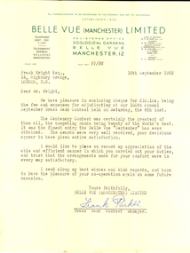
Letter - Correspondence, Frank Parker, 16/10/1952
Frank Wright was a renown resident of Smeaton, where he was born on 2 August 1901. He lived at Laura Villa, and attended Smeaton State School. His father William was a gold miner and his mother's name was Sarah. Their family won many singing and instrumental awards. Frank was tutored by Percy Code and was awarded a gold medal for the highest marks in the ALCM examinations in the British Colonies at the age of seventeen years. He became the Australian Open Cornet Champion by the age of eighteen. A year later, Frank conducted the City of Ballarat Band, and later the Ballarat Soldiers’ Memorial Band. He formed the Frank Wright Frisco Band and Frank Wright and his Coliseum Orchestra. These bands won many South Street awards, and Frank as conductor won many awards in the Australian Band Championship contest. In 1933 Frank Wright sailed to England to conduct the famous St Hilda’s Band and was later appointed Musical Director of the London County Council, where he organized many amazing concerts in parks, in and around the London district. He was made Professor of Brass and Military Band Scoring and conducted at the Guildhall of Music and Drama. Frank was often invited to adjudicate Brass Band Championships around Europe, in Australia, including South Street and in New Zealand. The Frank Wright Medal at the Royal South Street competition is awarded to an individual recognized as making an outstanding contribution to brass music in Australia.Letter from Frank Packer of Belle Vue (Manchester) Limited to Frank Wright, 1952Frank Wright Esq., 14, Highbury Grange, London, N.5. Dear Mr. Wright, We have pleasure in enclosing cheque for 10 pounds 10 shillings being the fee and expenses for adjudicating at our 100th Annual September Brass Band Contest held on Saturday, the 6th inst. The Centenary Contest was certainly the greatest of them all, the competing Bands being twenty of the World's best. It was the finest entry the Belle Vue "September" has ever obtained. The awards were very well received, your decisions appear to have given entire satisfaction. I would like ot place on record my appreciation of the able and efficient manner in which you carried out your duties, and trust that the arrangements made for your comfort were in every wat satisfactory. I send along my best wishes and kind regards, and hope to have the pleasure of your co-operation again on some future occasion. Yours faithfully, Belle Vue (Manchester) Limited Frank Parker Brass Band Contest Manager. belle vue, frank wright, letter, adjudicator, brass band -
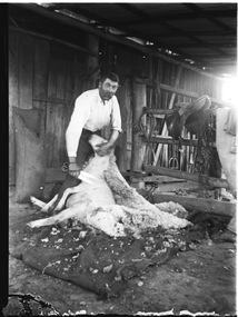 Wodonga & District Historical Society Inc
Negative - Haeusler Glass Negatives Collection - Harry Schuster blade shearing
The Wodonga Historical Society Haeusler Collection provides invaluable insight into life in late nineteenth and early twentieth century north east Victoria. The collection comprises manuscripts, personal artefacts used by the Haeusler family on their farm in Wodonga, and a set of glass negatives which offer a unique visual snapshot of the domestic and social lives of the Haeusler family and local Wodonga community. The Haeusler family migrated from Prussia (Germany) to South Australia in the 1840s and 1850s, before purchasing 100 acres of Crown Land made available under the Victorian Lands Act 1862 (also known as ‘Duffy’s Land Act’) in 1866 in what is now Wodonga West. The Haeusler family were one of several German families to migrate from South Australia to Wodonga in the 1860s. The Schuster family were also of German migrant background. Johannes Edward Schuster was born in Hoyles Plains, South Australia and with his wife Johanna and young family moved to Victoria circa 1882. He took up farming land in Wodonga West. The St John’s Lutheran Church Sunday school hall was erected from part of the proceeds of the sale of some 41 acres of land at Wodonga West, which had been bequeathed to the Wodonga congregation by the late Johannes Edward Schuster. This land was the original home site of the Schuster family on arrival from South Australia. Shearing - Although the first mechanised sheep shearing machine was created by James Higham, from Melbourne in 1868, the use of blade shears were more common well into the early 20th century. Pastoralists on smaller holdings continued to either shear their own sheep or employ blade shearers rather than outlay the cost of machines. In large sheds, professional shearers worked as they travelled the country. They would earn around 17 to 20 shillings per day in the early days of the wool industry. However mechanisation continued and by 1915 most sheep shearing sheds in Australia contained sheep shearing machines. The original machines were powered by steam and later combustion engines were used. This digital image was produced from one of the glass negatives that form part of the collection, probably taken by Louis Haeusler (b.1887) with the photographic equipment in the Wodonga Historical Society Haeusler Collection.This item is unique and has well documented provenance and a known owner. It forms part of a significant and representative historical collection which reflects the local history of Wodonga. It contributes to our understanding of domestic and family life in early twentieth century Wodonga, as well as providing interpretative capacity for themes including local history and social history.Digital image created from the Haeusler Glass negative collection. Harry Schuster shearing sheep using blade shears. wodonga pioneers, haeusler family, glass negatives, dry plate photography, blade shearing, schuster family -
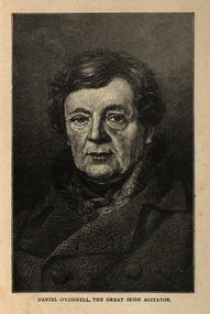 Ballarat and District Irish Association
Image, Daniel O'Connell, the Great Irish Agitator, c1864, c1864
Daniel O’Connell was born near Cahirciveen, Co. Kerry, on 6 August 1775. His wealthy childless uncle adopted him at an early age and brought him up at Derrynane. He spoke Irish and was interested in the traditional culture of song and story still strong in Kerry at the time. He also understood how the rural mind worked which served him well in later years. In 1791 he was sent to school at St. Omer and Douai and what he saw there of the French Revolution left him with a life-long hatred of violence. He read law at Lincoln’s Inn (1794 -96) and continued his studies in Dublin where he was called to bar in 1798. He had soon built up an enormous practice. The 1798 rising and the terrible butchery that followed it confirmed his horror of violence. While he approved of the principles of the United Irishmen, their call for reform and for Catholic Emancipation, he disagreed with their methods. In 1815 O’Connell criticised harshly the Dublin corporation. O’Connell was challenged to a duel by one member D’Esterre. In the exchange of shots D’Esterre was killed and O’Connell vowed never to fight again. O’Connell was soon drawn into political action. Hopes of Catholic emancipation had been raised by promises given while the act of union was being passed. In 1823, O’Connell founded the Catholic Association. The aim of the organisation was to use all the legal means available to secure emancipation. It turned into a mass crusade with the support of the Catholic clergy. All members of the association paid a membership of a penny a month (the Catholic rent). This helped to raise a large fund. The Clare election in 1828 was a turning point. O’Connell, with the support of the forty-shilling freeholders, managed a huge victory against the government candidate. He was well supported by the clergy whose influence on the poor uneducated peasant class was enormous. The polling took place in Ennis at the old courthouse where the O’Connell monument now stands. At the final count, O’Connell was elected by a majority of about eleven hundred votes. The ascendancy party had suffered its first big knock since 1798. The whole country was aflame. The British Government feared a rising and granted Catholic emancipation in April 1829. The franchise was, however, raised to 10 pounds which excluded the forty-shilling freeholders. O’Connell was now the undisputed leader in Ireland and he gave up his practice at the bar to devote his time entirely to politics. At the King’s insistence, O’Connell was not allowed to take his seat until he had been re-elected for Clare. In February 1830, O’Connell became the first Catholic in modern history to sit in the House of Commons. For the rest of his life, he was supported by “The O’Connell Tribute”, a public collection out of which O’Connell paid all his expenses. O’Connell now decided to concentrate on winning repeal of the act of union and getting an Irish parliament for the Irish people. British political leaders feared repeal as they did not fear emancipation. They saw repeal of the Act of Union as the first step in the break-up of the act of union, as the spirit of the repeal movement was revived when the young Ireland writers wrote about it in the Nation. In 1841, O’Connell was elected Lord Mayor of Dublin and in 1843 the subscriptions to his Repeal Association, the Repeal “Rent” came to 48,400 pounds. He now began to organise monster meetings throughout the country. It is thought that three-quarters of a million people gathered on the hill of Tara to hear the man they called the “Liberator”. The government became alarmed at the strength of the Repeal Movement and a meeting which O’Connell had planned for 8 October 1843 in Clontarf, Dublin was banned. Huge crowds were already on their way when O’Connell called off the meeting to avoid the risk of violence and bloodshed. He was charged with conspiracy, arrested and sentenced to a year in jail and a fine of 2,000 pounds. The sentence was set aside after O’Connell had been three months in prison. When he was released he continued with his campaign for repeal. However, a turning point had been reached. The tactics that had won emancipation had failed. O’Connell was now almost seventy, his health failing and he had no clear plan for future action. There was discontent within the Repeal Association and the Young Irelanders withdrew. There was also some failure in the potato crop in the 1840’s, a sign of things to come in the Great Famine of 1845-1847. Aware of the fact that he had failed with his great goal, (the Repeal Movement), O’Connell left Ireland for the last time in January 1847. He made a touching speech in the House of Commons in which he appealed for aid for his country. In March, acting on the advice of his doctor, he set out to Italy. Following his death in Genoa on 15 May 1847, his body was returned to Ireland and buried in Glasnevin Cemetery. [http://www.clarelibrary.ie/eolas/coclare/people/daniel.htm, accessed 13/12/2013]Portrait of a man known as Daniel O'Connell.ballarat irish, daniel o'connell, o'connell -
 Flagstaff Hill Maritime Museum and Village
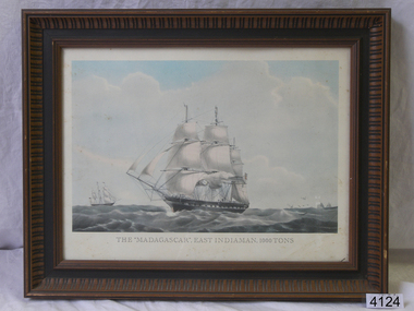
Print - Lithograph Picture, Madagascar Indiaman, Unknown
Madagascar was a large British merchant ship built for the trade to India and China in 1837 that disappeared on a voyage from Melbourne to London in 1853. The disappearance of Madagascar was one of the great maritime mysteries of the 19th century and has probably been the subject of more speculation than any other 19th-century maritime puzzle, except for the Mary Celeste. Madagascar, the second Blackwall Frigate, was built for George and Henry Green at the Blackwall Yard, London, a shipyard that they co-owned with the Wigram family. A one-eighth share in the vessel was held throughout her 16-year career by her first master Captain William Harrison Walker Walker. Madagascar carried freight, passengers, and troops between England and India until the end of 1852. In addition to her normal crew, she also carried many boys being trained as officers for the merchant marine. Known as midshipmen from naval practice, their parents or guardians paid for their training, and they only received a nominal wage of usually a shilling a month. Due to the Victorian Gold Rush, Madagascar, under the command of Captain Fortescue William Harris, was sent to Melbourne with emigrants. She left Plymouth on 11 March 1853 and, after an uneventful passage of 87 days, reached Melbourne on 10 June. Fourteen of her 60 crew jumped ship for the diggings, and it is believed only about three replacements were signed on. She then loaded a cargo that included wool, rice, and about two tonnes of gold valued at £240,000, and took on board about 110 passengers for London. On Wednesday 10 August, just as she was preparing to sail, police went on board and arrested a bushranger John Francis, who was later found to have been one of those responsible for robbing on 20th July the Melbourne Private Escort between the McIvor goldfield at Heathcote, Victoria and Kyneton. On the following day, the police arrested two others, one on board the ship and the other as he was preparing to board. As a result of these arrests, Madagascar did not leave Melbourne until Friday 12 August 1853. After she left Port Phillip Heads Madagascar was never seen again. When the ship became overdue many theories were floated, including spontaneous combustion of the wool cargo, hitting an iceberg and, most controversially, being seized by criminal elements of the passengers and/or crew and scuttled, with the gold being stolen and the remaining passengers and crew murdered. There have been many rumors as to what happened to Madagascar over the years but what really happened is still a mystery. The lithograph was made around 1950 from an original painting of Madagascar a Vessel with a notorious past and is interesting and a significant item for the ships part in early Victorian history. The picture is it’s self not valuable or can be associated with a significant person in history. The interest lies in the events that are linked to the ship in the mid 19th century.Lithograph of the ship Madagascar, in a wooden frameThe Madagascar East Indiaman 1000 tonsflagstaff hill, warrnambool, shipwrecked-coast, flagstaff-hill, flagstaff-hill-maritime-museum, maritime-museum, shipwreck-coast, flagstaff-hill-maritime-village, lithograph, the madagascar, east indiaman -
 Brighton Historical Society
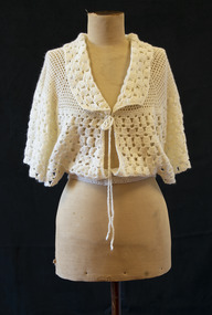
Bed jacket, circa 1955
This bed jacket was crocheted for Carmela Materia (1931-2018) by her mother, Giuseppa Auditore, around the time they emigrated from Italy to Melbourne. Both women were longtime Brighton locals, residing in the area from the 1950s until their deaths. Carmela Auditore was the first woman from her home village of Scaletta, Italy to emigrate to Australia. Setting sail alone in 1950 at the age of 19, she joined her brother John and uncle Frank in McCallum St, Brighton. Frank had arrived some years earlier and had spent the duration of the First World War in an internment camp. John worked at the Brighton Case Company, a box manufacturer on Nepean Highway, and paid for her passage. Carmela found a job sewing children's clothing at Drummonds, a small factory in Church St. Working eight hours a day, five days per week, netted her a weekly wage of three pounds. To earn a little extra, she washed dishes at a St Kilda Road restaurant for ten shillings a shift. Her parents, Salvatore and Giuseppa Auditore, joined her in Brighton in 1952. They rented a house behind an antique shop in Bay Street. Salvatore had been a fisherman in Scaletta, but quickly adapted to the job he found helping around the Garage at Brighton Motors in Male Street. On 14 February 1953, Carmela married her sweetheart, Salvatore Materia, at St James Catholic Church in Gardenvale. Salvatore had been living with his aunt in Well Street and worked on the wharves. Both Carmela and Salvatore were hard workers. They owned a fruit shop in Church Street where Woolworths now stands, and years later Carmela recalled the familiar 6am tap on her window each morning when her husband returned from the market. On dark winter mornings, she felt as if her hands would freeze as she helped Salvatore unload cold cabbages and cauliflowers from his truck. They later owned a shop in Ludstone Street in Hampton. After Salvatore died suddenly at the age of 48, Carmela returned to sewing, working at the Willow Fashions knitting mill in Gardenvale. She later went into partnership with her sister and brother-in-law, this time in the delicatessen business. Her parents, Giuseppa and Salvatore, spent the rest of their days with Brighton. Carmela recalled her father cheerfully walking the streets, greeting people by name. He knew everybody. He loved being in Australia and enjoyed life to the last, insisting on having bread and wine on the table at every meal.Cream crocheted wool bed jacket. Loose around bust with wide sleeves and open sides. Fastens at collar with thin braided ties, and at waist with two pearlescent plastic buttons.bed jacket, migration, 1950s, carmela auditore, carmela materia, giuseppa auditore -
 Melton City Libraries
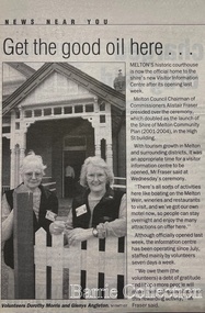
Newspaper, Get the good oil here…, 2001
"A court was established in Melton by 1864, when the first recorded case was heard before Mr BA Porter JP, with Mr A Carroll as the Clerk of Courts. John James was convicted of being drunk, for which he was fined five shillings or 24 hours imprisonment. The court was held in the ‘long room’ of the old Melton Hotel, before moving to rented accommodation at the Raglan Hotel, and finally to the Roads Board office. Tenders for construction of the present building were called for by the Public Works Department on 13th February 1892. The architect Samuel Edward Brindley was born in Birmingham, England, in 1842. He was articled to the local architect, J.R. Botham, FRIBA, before emigrating to Victoria where he was employed as an architect in the Education Department from 18 August 1873. With the amalgamation of the architectural branch of the Education Department with the Public Works Department in 1884, Bindley was placed in charge of Victorian government building design for the North-Western District. In 1975, the Melton and District Historical Society became concerned at hearsay that the court house was to be demolished to make way for carparking space. Melton had been declared a ‘satellite city’ and was developing rapidly. A new shopping centre had recently been built at a setback of 60 feet (c.18 metre) from 323-329 High Street, and the court house, together with the adjacent weatherboard police station, had been left standing alone. A new police station was planned, and the weatherboard police station was subsequently demolished. In its nomination of the building for National Trust classification the Society argued that the Court House was ‘the best of two early buildings left in the main street’ (the other being a bluestone hotel) and that its loss would be ‘tragic’. However the nomination was unsuccessful, the National Trust at the time judging that it was of no particular ‘distinction’ or ‘antiquity’. The building continued to be used as a court house at least until 1991 when the Department of Housing and Construction (formerly the PWD) conducted a heritage study of court houses. By this time Federation-era architecture had achieved acceptance within the heritage movement. The building was recognised as being ‘the only surviving example in brick of the Federation Queen Anne style which was used for court houses only twice.’ Twenty years later when it was proposed to modify the eastern façade of the building to accommodate a café, the M&DHS was again concerned. This time the National Trust objected that the proposed extension would be an over-development of the site, and questioned the changes to the interior court room furnishings and fittings. The site never appears to have been nominated to the Victorian Heritage Register. It has since been converted into the Shire of Melton Tourist Information Centre". Opening of the Visitor Centre in Meltoncouncil, local architecture -
 Bendigo Historical Society Inc.
Map - GUIDE MAP OF BENDIGO & EAGLEHAWK, Late 1920's
Map. Guide map of Bendigo & Eaglehawk. Folded map of Bendigo & Eaglehawk with blue outer cover booklet. Map is compiled by E E Parker, Eaglehawk. Map shows tramways, bus routes and cost one shilling. Map shows Agricultural Showgrounds located between Park Street, Water Street, Barnard Street and Bridge Lane. Also shows Acclimitization Reserve located behind the Botanical Gardens at White Hills. Shows the location of Sailors Gully, Peg-Leg Gully, Jobs Gully, California Gully, Long Gully, Ironbark Gully, Golden Gully, Poverty Gully, Sheepshead Gully, Charcoal Gully, Eaglehawk Creek, Bendigo Creek and Back Creek.Contains interesting facts about Bendigo:- Area - 7,900 acres, Population - 26,000, First Council elected - 1855, Proclaimed a City - 1871. Gold Rush broke out - 1851. For first 10 years gold yield averaged 8,600 ozs. Per week. Total gold yield to 1923 - 572 tons valued at 82,000,000 pounds. Deepest mines - Victoria Quartz 4,614 ft., New Chum Railway 4,318 ft., 13 mines over 3,000ft. deep, 53 mines over 2,000 ft. deep. Sewering of City commenced 1922. All principal buildings now sewered. Map printed by Arnall & Jackson, General Printers, Stationers & Engravers, 476 Collins Street. Outer map blue cover printed in red and blue ink by J B Young, Lithographer. Map displays advertisement for Bendigo Timber Co. Outer blue cover displays advertisement for Campbell Connelly & Co. Pty. Ltd, Ironmongers, Timware Manufacturers, Plumbers, Sewerage Contractors, High and Forest Sts, Bendigo 9outside back cover) and for Hartleys ( J L Shoosmith) Bendigo, displaying Indian Motor Cycles (inside back cover).map, bendigo, township, guide map of bendigo & eaglehawk -
 Bendigo Historical Society Inc.
Document - FATHER SYDNEY MACEWAN - TENOR, 16 Aug, 1956
The Australian Broadcasting Commission has pleasure in presenting Father Sydney MacEwan (Tenor). Victorian Country Tour 8.15pm. Associate Artist: John Douglas Todd, Pianist. Albury, Regent Theatre, Wed., 25th July. Ballarat, Regent Theatre, Thurs., 2nd Aug. Bendigo, Princess Theatre, Thurs., 16th Aug. Programme One Shilling. Listing of records by Father Sydney MacEwan imported in from England and 2 Australian made records available in local music stores. Father Sydney MacEwan is on his third visit to Australia. The first in 1936 and second in 1948, when he was invited to attend the Centenary of the Roman Catholic Diocese in Melbourne. It was not long after the first trip to Australia, and tours of Canada, the USA and Europe that Sydney MacEwan decided to become a priest, and renounced tempting radio and concert contracts. During the war he was an officiating Chaplin to the RAF Father MacEwan's normal duties as a parish priest . . . John Douglas Todd Tasmanian born in Tasmaniabut lived most of his life in Sydney. As associate artist with father MacEwan, John Douglas Todd, Sydney pianist, is making his sixth tour for the ABC and his second tour with Father MacEwan. He previously toured for the ABC with violinist Jeanne Gautier and singers William Warfield, Lord Lurgan and John Dudley. . . Programme Notes. Australian Broadcasting Commission R J Boyer, E R Dawes, Sir John Medley, The Hon. Dame Enid Lyons, P W Nette, P Vanthoff, C W Anderson, Charles Moses, Conrad Charlton, Dorrie O'Neil. Alceo Galliera conducting the Victoria Symphony Orchestra, Soloist Mervyn Simpson, Trumpet. Coming concert dates Bendigo & Albury. Peter Dawson, Baritone with the Victorian Symphony Orchestra Concert Date. Advertisements for Georges of Collins St., Berlei, Wynvale Wines. Includes photographs of Father Sydney MacEwan & John Douglas Todd. 8 pages plus cover.program, theatre, father sydney macewan, the australian broadcasting commission pesenting father sydney macewan (tenor). victorian country tour associate artist: john douglas todd, pianist. bendigo, princess theatre, thurs., 16th aug. programme one shilling. records by father sydney macewan imported and 2 australian made records available music stores. 3rd visit to australia. 1st in 1936 & 2nd in 1948, centenary of the roman catholic diocese in melbourne. 1st trip to australia, and tours of canada, the usa and europe that sydney macewan decided to become a priest. during the war he was an officiating chaplin to the raf. john douglas todd tasmanian born lived life in sydney. associate artist with father macewan, john douglas todd, sydney pianist, 6th tour for the abc and 2nd tour with father macewan. he toured for the abc with violinist jeanne gautier and william warfield, lord lurgan and john dudley. programme notes. r j boyer, e r dawes, sir john medley, the hon. dame enid lyons, p w nette, p vanthoff, c w anderson, charles moses, conrad charlton, dorrie o'neil. alceo galliera conducting the victoria symphony orchestra, soloist mervyn simpson, trumpet.. peter dawson, baritone with the victorian symphony orchestra georges of collins st., berlei, wynvale wines. photographs of father sydney macewan & john douglas todd. -
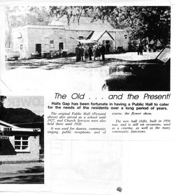 Halls Gap & Grampians Historical Society
Newspaper - Photocopy
The article shows a photo of the original Hall's Gap Hall and the (then) new Hall, which was built in 1956. The copy has been scanned as two separate images (because it was too large for the scanner). the second image is stored under "Additional Images". HISTORY OF HALL'S GAP HALL: No village, no matter how small, could possibly survive without a public meeting place, and Hall's Gap was no exception, even in 1899-1900. Actually it was the locals of Stony Creek village, as Hall's Gap was known for a short time, who decided to hold a meeting to find out how much interest there was in building a town hall! They soon found out that support was overwhelming, as can be seen by the fact that 14 gentlemen nominated for a position on the committee of four! Several motions were moved at that meeting, mainly with reference to the materials to be used, for instance that no "wattle and daub", but rather slabs of bark and local bush logs be used. The walls were to be constructed of slabs, 6 feet long, 9 inches wide and two inches thick. Uprights were to be 9 feet high and at least 9 inches thick. Sheets of bark, all 32 of them, had to be 8 feet by 8 feet. Tenders for the building materials were called on 9 March 1899 and, 21 days later, McKeon Brothers won the right to supply all the material for the princely sum of 4 pounds 10 shillings. The size of the hall was to be 20 feet by 10 feet. The first hall served the community well for the next thirteen years, being regularly used as a place of entertainment and religious worship. The growing community soon realised the need for a larger venue, with better facilities, so once again the townsfolk rallied to raise funds for a new hall, realising their dream around 1913. In 1921 a schoolteacher was provided by the education department but as there was no school building she was expected to use the hall. Mainly lessons were held in the kitchen as it was much warmer than the hall itself, and it was not unusual for up to twenty children to be taught, ranging in age from 5 to 14 years. It was not until 1928 that an official school was built. 1955-56 were years of great excitement. The Progress Association was in charge of deciding the format for the new hall, and there were many rowdy meetings beforehand. Some members had much more vision than others, and to some the amount of money required seemed astronomical. Two hall committee members resigned over differences of opinion but amazingly it all came together in the end, albeit at a greater cost than had been anticipated. There is only one record of a grant being made for the building,1500 pounds, and it came for the Minister of Public Works. Estimated cost of the building was around 8,000 pounds, and when finally finished it was just slightly over, but bank charges and interest took it to well over 9,000 pounds. An electric light generator was included and lighting installed. The SEC electricity was connected in 1962.A copy of a newspaper article entitled 'The Old . . . and the Present!', which includes two photographs.buildings, halls -
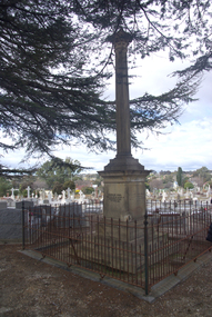 Ballarat Heritage Services
Photograph - Photograph - Colour, Burke and Wills Memorial at Bendigo Cemetery, 2018, 02/09/2018
Robert O'Hara Burke and Thomas Pope Besnard were childhood friends. As sexton of the local Back Creek Cemetery Thomas Besnard organised a subscription to raise the money for a monument to Burke, Wills and Gray. A subscription of one shilling, no more and not less, was asked so all subscribers were equal. The Bendigo monument was designed by Adam Duncan and features a Corinthian column mounted on a foundation stone, topped with a Grecian urn draped with the Union Jack. The stone for the monument was quarried from New Chum Mine. The site in the Bendigo Cemetery was selected by Besnard so the monument was on a grass knoll well clear of any other graves. The design included landscaping with a path and garden beds that provided dignified access. The Burke and Wills Monument in Bendigo has been entered on the Register of the National Estate as being important for its association with historical events and developments associated with exploration in the early days of Colony of Victoria. Two conifers remain from the original group sent by Mueller of the Melbourne Botanical Gardens to develop the garden layout on the knoll. These two trees are listed as Significant Trees by City of Greater Bendigo. The foundation block was laid on 20 August 1862 by Chairman of the Bendigo Municipality, Charles Burrows – exactly two years after the Expedition left Melbourne. A half day holiday was declared by Bendigo Council, and a procession left the Bendigo Town Hall and marched to the cemetery where 8000 people were gathered and another 4000 lined the route. John King was unable to attend due to ill health. Chairman of the Municipality of Bendigo, Charles Burrows, gave a long address, and diaries of members of the expedition, the Sandhurst Almanac, the Bendigo Advertiser, the Bendigo Independent Evening News, photographs of the deceased, photographs of Public Buildings in Bendigo, a Sydney half sovereign and all the silver coins of the Realm were wrapped in a Union Jack and placed in a niche in the foundation stone. Fifteen months later a column was erected on the foundation stone after Besnard openly criticised the Memorial Committee for their lack of action. The Bendigo Advertiser was disappointed at the location of the monument preferring a more central location and in 1893 an attempt was made to move the monument to Rosalind Park. On 19 May 1893, Mr Minto, the City Surveyor of the Bendigo MunicIpality reported it would cost £25, and no other action occurred. In 1940 the land around the memorial was sold off as grave sites and the paths and garden beds disappeared with graves now surrounding the base of the monument. The Burke and Wills Monument in Bendigo Cemetery was entered on the Register of the National Estate for its association with historical events and developments associated with exploration in the early days of Colony of Victoria. Two conifers remain from the original group sent by Mueller of the Melbourne Botanical Gardens to develop the garden layout on the knoll. These two trees are listed as Significant Trees by City of Greater Bendigo.Burke and Wills Memorial at Bendigo Cemetery, 2018Erected by the people of Bendigo in honor of the Victorian Explorers, Burke, Wills, Gray and King who first crossed the continent of Australia. King alone surviving the privation and suffering under which his three brave ill-fated companions sank. A.D. 1862. Robert O'Hara Burke, leader of the Victorian Expedition, left Melbounre 24th August 1860. Reached Carpentaria 12th Feby 1861. Died on his return at Coopers Creek, 30th June 1861. Charles Gray, died also on his return at Polygorum Swamp. 17th April 1861. William John Wills, second in command, died also near Coopers Creek, 29th June 1861. bendigo cemetery, burke and wills, burke and wills memorial, william john wills, john o'hara burke, charles gray, polygonum swamp, coopers creek, victorian expedition, carpentaria, bendigo public cemetery, bendigo remembrance park, thomas pope besnard -
 Eltham District Historical Society Inc
Photograph - Digital Photograph, Alan King, Eltham Court House, 730 Main Road, Eltham, 28 December 2007
The Eltham Court House is Eltham's oldest public building. It was classified by the National Trust in 1977. In 1857 five Eltham residents petitioned the licensing magistrates of the Heidelberg district asking for better police protection, including from itinerant gold prospectors who turned to crime when their quest was unsuccessful. In response the Eltham Courthouse was constructed in 1860. Over the years it has also been used for other activities, including for electoral polling purposes, inquests, early meetings of the Eltham Roads Board and even as an overflow classroom. This type of localised solution is characteristic of the self-reliance preserved in Eltham today. The court house is an important symbol of the spirit which makes Eltham distinctive as a community. The Eltham Courthouse is historically significant because its construction was intended to emphasise the centralised control over law and order in the Colony of Victoria in the wake of the 1852 Snodgrass committee report on the Victorian police force and the resulting Police Regulation Act (1853). The nature of the Court House planning and use of architectural devices make the building's function easily interpreted. The arrangement of rooms, with public entry and clerical rooms to the rear, and the use of raised floor levels throughout these spaces to signify relative rank is easily perceived. The distinction in entries, public, magistrate and person-in-custody, and the existing court furniture enhances appreciation of this building. The Eltham Court House is one of only two intact examples in the state of this simple design with projecting entry. The building is of architectural significance because it retains intact early features. These include use of handmade bricks, simple decoration, roof trusses, timber ceiling boards, original windows, doors and associated hardware and a collection of court furniture. Additions to the court house have been done in a manner which did not interfere with the fabric of the original building. Typical cases heard before the Court of Petty Sessions included financial debt, straying livestock, theft, assault, drunkenness, public disorder, truancy, motor vehicle offences, unregistered animals and failing to have children attend school, or be vaccinated. The courthouse operated for over 120 years before it closed in 1985. In April 2021, Nillumbik Shire Council authorised restoration of the building and furnishings. The extensive works required for the total restoration of this highly valued heritage building was undertaken by Ducon Building Solutions and other specialist contractors. Covered under Heritage Overlay, Nillumbik Planning Scheme. Victorian Heritage National Trust of Australia (Victoria) State significance Published: Nillumbik Now and Then / Marguerite Marshall 2008; photographs Alan King with Marguerite Marshall.; p65 A demand for better police protection resulted in the building of the Eltham Courthouse and the police residence beside it. In 1857 five Eltham residents petitioned the Heidelberg district licensing magistrates. They pointed out that Eltham had two hotels, a population of about 1000, and many strangers employed on the public roads. Yet the nearest police were at Heidelberg eight miles (12.8km) away, or at the Caledonia Diggings 21 miles (33.7km) away.1 Subsequently the courthouse and then the police residence, near the corner of Main Road and Brougham Street, were built in 1859/60. The courthouse is Eltham’s oldest public building and the National Trust classified it in 1977. It ceased operation in 1984 and has since been used by local groups. There are only six other known examples of similar small brick country courthouses in Victoria . For £536, a Mr Duncan built the courthouse – a neat, narrow, oblong building with handmade orange bricks. Its gabled roof and porch are covered with brown slate tiles and it has 12-paned windows. Inside, the roof is peaked and the courthouse is still ventilated by oblong slits near the ceiling. Most of the fine carved timber and upholstered furniture is original. The original prisoners’ door, now permanently closed, led from the police station to the dock. Builders, Langridge Wright and Witney built a timber police station (since demolished) and a brick residence to its north,2 for £1150/7/-. Built around the same time were the lock-up behind the residence, also later demolished, and the two-storey orange brick stables. The former police residence also has a brown slate roof and handmade bricks. The front veranda roof is made of corrugated iron, as is the roof of the back weatherboard extension. The application for police protection was approved within a few months and police operated from a cottage rented at ten shillings a week and owned by William Jarrold. This was probably the one at the corner of Main Road and Dalton Street called Jarrold or White Cloud Cottage. In 1858 a second constable was appointed to Eltham following a fight at the hotel. The timber police office a replica of which was built in the early 1990s is at the building’s side. The lock-up was demolished following the relocation of the police to a new station in about 1952. The residence has been used as the Eltham District Historical Society centre since 1997. Records show court cases were held at Eltham before the courthouse was built, but the location is unknown. Some court cases were not very different from those today. In 1891 a man was charged with being drunk while in charge of a horse and was fined ten shillings. The courthouse was used for other purposes during its long history. It was probably used as a polling place as indicated by old photographs of election-day crowds outside. The Eltham Road Board met there from the early 1860s until 1868 when the Board transferred to Kangaroo Ground. During the same period the Road Board Secretary used the courthouse as an office until 1867 when it was transferred to his home at Wingrove Cottage. The courthouse was also used as an overflow classroom for the Dalton Street school in 1875. The two buildings can further link us with Eltham’s early days through Police Department correspondence. The first constable-in-charge was George Reid. In 1860 a letter to The Argus newspaper signed ‘A Sufferer’ declared the Eltham police were not active enough in their duties. The writer suggested that the ‘very snug’ police quarters were too comfortable, and he detailed various incidents including one of an alleged break-in to the Road Board Secretary’s home. But the Board Secretary, C S Wingrove, wrote to the Police Department refuting The Argus letter saying he had received full co-operation from Sen. Constable Peter Lawler.This collection of almost 130 photos about places and people within the Shire of Nillumbik, an urban and rural municipality in Melbourne's north, contributes to an understanding of the history of the Shire. Published in 2008 immediately prior to the Black Saturday bushfires of February 7, 2009, it documents sites that were impacted, and in some cases destroyed by the fires. It includes photographs taken especially for the publication, creating a unique time capsule representing the Shire in the early 21st century. It remains the most recent comprehenesive publication devoted to the Shire's history connecting local residents to the past. nillumbik now and then (marshall-king) collection, eltham, eltham court house, main road -
 Bendigo Historical Society Inc.
Document - VICTORIAN SYMPHONY ORCHESTRA, CAPITAL THEATRE, BENDIGO, 20 Oct,1960
Victorian Symphony Orchestra, Capital Theatre, Bendigo. Thursday, 20th October, 1960, 8pm. Conductor: Rudolf Pekarek. Soloist: Jiri Tancibudek (Oboist). Programme One Shilling. Rudolf Pekarek (includes photograph) Czech born. The A.B.C.'s resident conductor of the Queensland Symphony Orchestra, can look back on forty year's experience as a conductor of the symphony orchestras. He is chiefly remembered in has native Prague for his founding of the Film Opera Koncert Orchestra, the predecessor of the Prague Symphony Orchestra. Studied oboe and violin. Founded F.O.K Orchestra in 1933. Often a guest conductor of the Czech Philharmonic and Vienna Symphony Orchestras. During WWII spent four years working in Polish mines as a prisoner of the Germans. Escaped in 1944, joined Czech liberators. Appointed director of the Army of the Arts Ensemble of the Czechoslovakian Liberation Army. After coming to Australia in 1949, Pekarek spent four years in Perth as . . . Jiri Tanibudek ( including Photograph) Principle oboe with the Victorian Symphony Orchestra, formerly played with the Czech Philharmonics Orchestra in Prague. Appointed with the V.S.O. in 1953, naturalized in 1956. Played with Smetana String Quartet. Australia invited him as Professor of Oboe at the New South Wales Conservatorium. Returned overseas . . . Programme. Analytical Notes . . . The Australian Broadcasting Commission acknowledges with thanks the valuable advice and assistance received from The Wangaratta Arts Council and The Music Advancement Society of Bendigo in the presentation of these concerts. A.B.C. Sir Richard Boyer, K.B.E., M.A., Chairman. E R Dawes, C.M.G., Vice-Chairman. Sir John Medley, KT., D.C.L., LL.D., M.A. The Hon. Dame Enid Lyons, G.B.E. Miss Rhonda Felgate, M.B.E. A G Lowndes, M/SC. H B Halvorsen, F.C.A., F.C.I.S. Charles Moses, C.B.E., General Manager. Ewart Chapple, Manager for Victoria. Charles Buttrose, Director of Publicity and Concerts. H Cannon, Director of Music. Ray Humphrey, Concert Manager for Victoria. Advertisements: Brashs, His Masters Voice, Philips, Country Club.program, music, music advancement society bendigo, victorian symphony orchestra, capital theatre, bendigo. 20th october, 1960. conductor: rudolf pekarek. soloist: jiri tancibudek (oboist). rudolf pekarek (includes photograph) czech born. the a.b.c.'s resident conductor of the queensland symphony orchestra. remembered in prague for founding of the film opera koncert orchestra, the predecessor of the prague symphony orchestra. studied oboe and violin. founded f.o.k orchestra in 1933. often a guest conductor of the czech philharmonic and vienna symphony orchestras. during wwii spent years in polish mines as a prisoner of germans. escaped in 1944, joined czech liberators. director of the army of the arts ensemble of the czechoslovakian liberation army. australia in 1949, pekarek spent four years in perth. jiri tanibudek ( including photograph) principle oboe with the victorian symphony orchestra, formerly played with the czeh philharmonis orchestra in prague. appointed with the v.s.o. in 1953, naturalised in 1956. played with smetana string quartet. professor of oboe at the new south wales conservatorium. . programme. analytical notes . . . the australian broadcasting commission acknowledges with thanks the valuable advice and assistance received from the wangaratta arts council and the music advancement society of bendigo. a.b.c. sir richard boyer, k.b.e., m.a., chairman. e r dawes, c.m.g., vice-chairman. sir john medley, kt., d.c.l., ll.d., m.a. the hon. dame enid lyons, g.b.e. miss rhonda felgate, m.b.e. a g lowndes, m/sc. h b halvorsen, f.c.a., f.c.i.s. charles moses, c.b.e., general manager. ewart chapple, manager for victoria. charles buttrose, director of publicity and concerts. h cannon, director of music. ray humphrey, concert manager for victoria. advertisements: brashs, his masters voice, philips, country club. -
 Flagstaff Hill Maritime Museum and Village
Functional object - Spectacles and Case, Carter & Foord, 1902-1930s
The spectacles and case are an example of eyewear from the early 20th century. The case was made by Carter & Foord of Ballarat. According to the tag inside, the spectacles frame cost three pounds, three shillings and sixpence (£3.3.6). Carter & Foord was established in 1902. The firm advertised as opticians, oculists, watchmakers and jewellers. The staff repaired scientific instruments and were sole agents for the gramophone, demonstrating its advantages whenever there was an opportunity. In 1902 the business was located at 46 Lydiard Street, Ballarat. The staff in the ophthalmic department, under the care of Harold Foord, specialised in sight testing using up-to-date equipment and this service was free of charge. Customers were promised that they would be fitted with glasses guaranteed to correct the most complex sight. Mr F M Clacius performed the grinding of specific lenses. Julia Carter, Harold Foord and Clacius were all formerly from the business Carter & Warner, which had been sold to Frederick Clark around 1903 after Mr Carder passed away. Carter & Foord operated a few doors away from the former business. In 1912 advertisements in the Geelong Advertiser invited the community to visit Harold Foord, of Carter & Foord, to have their eyes examined at no charge. These spectacles are similar to others in the W.R. Angus collection, donated by the family of Dr W R Angus, surgeon and oculist. The W.R. Angus Collection spans the years 1885 to the mid-1900s and includes historical medical and surgical equipment and instruments from the doctors Edward and Thomas Ryan of Nhill, Victoria, with whom Dr Angus worked for several years. Dr Tom and his brother had worked as surgeons including in eye surgery. Dr Tom Ryan performed many of his operations in the Mira private hospital on his premises. When Dr Angus bought into the Nelson Street premises in Nhill he was also appointed as the Nhill Hospital’s Honorary House Surgeon 1933-1938. Dr Angus married Gladys in 1927 at Ballarat, the nearest big city to Nhill where he began as a Medical Assistant and had been Acting House surgeon at the Nhill hospital where their two daughters were born. Dr Angus and his family moved to Warrnambool in 1939, where Dr Angus operated his own medical practice. He later took on the part-time role of Port Medical Officer and was the last person appointed to that position. After convalescing from injury resulting from his service during WWII, Dr Angus studied ophthalmology at the Royal Melbourne Eye and Ear Hospital. He created cosmetically superior artificial eyes by pioneering the use of intrascleral cartilage. Angus received accolades from the Ophthalmological Society of Australasia for this work. He returned to Warrnambool to commence practice as an ophthalmologist, pioneering artificial eye improvements. He had been an Honorary Consultant Ophthalmologist at Warrnambool Base Hospital for 31 years. He made monthly visits to Portland as a visiting surgeon, to perform eye surgery. Both Dr Angus and his wife were very involved in the local community, including the planning stages of the new Flagstaff Hill and the layout of the gardens there. Dr Angus passed away in March 1970.The Carter &O Foord spectacles are significant as an example of early 20th-century eyewear and fashion. They are connected to the history of regional Victoria, being made in Ballarat and purchased for local use. The spectacles are significant for being connected to the W.R. Angus Collection, which is important for still being located at the site connected to Doctor Angus, Warrnambool’s last Port Medical Officer. Dr Angus and his wife brought their young family to Warrnambool in 1938 and he remained a resident until his death in 1970. Early in his profession in the town of Nhill, Dr Angus assisted Dr Tom Ryan in his pioneering use of X-rays and in ocular surgery, and Dr Angus later inherited these items. The W.R. Angus Collection includes these medical instruments and other related equipment and is culturally and historically significant as an example of the medical practice of the late 19th to the mid-20th century. Other items in the collection relate to Dr Angus’ service in the Flying Doctor Service and the Army.Spectacles in a hard brown textured case with rounded corners and a hinged lid. The case is lined with brown velvet. The opaque yellow oval frames, raised at the outer top corners, are decorated with sparkling jewell decorations on the bridge. The arms are reinforced with metal inside. Also in the case is a pale blue cleaning cloth and a cardboard price tag with handwritten text. An inscription in gold lettering is stamped inside the case. The case was made by Carter & Foord of Ballarat. The design of the frames is called ‘ewell These spectacles are part of the W.R. Angus Collection.Stamped: “CARTER & FOORD / STURT ST BALLARAT” Handwritten label: “JEWELL / £3.3.6”flagstaff hill, warrnambool, maritime village, maritime museum, shipwreck coast, great ocean road, dr w r angus, dr roy angus, dr ryan, warrnambool oculist, port medical officer, nhill base hospital, mira hospital nhill, oculist, spectacles, eyewear, glasses, carter & foord, ballarat oculist, w.r. angus collection, ophthalmology, royal melbourne eye and ear hospital., artificial eyes, intrascleral cartilage, eye surgery -
Surrey Hills Historical Society Collection
Programme - Ephemera, Chatham Primary School Fathers' Club 'Trial by Jury' programme, 16/11/1929
The program describes the performance as 'original burlesque' and was written, composed and produced by A E Woffinden and A W Sutton, members of the Chatham Fathers' Club, to raise money for the school. There were 250 programs printed at a cost of one pound fifteen shillings. This performance starred 21 of the fathers with Mr W Crellin as the only female character, Miss Eileen Flapper. The Chatham Fathers' Club became renowned locally for the quality of its performances, repeats being given to other community organisations. In the publication 'Chatham Past & Present: A Patchwork of People' there is also a photo of the cast taken in the quadrangle of the school. The original program and photo were lent to the school at the time of the 70 year reunion in 1997 by Mrs Jean Lacy (nee Walker), whose father took part as a member of the jury. Many of the performers were also in the formal photo of the Father's Club, taken in February 1928 on the front steps of the school. The original hangs in the school entry foyer and is reproduced in 'A Patchwork of People: Chatham Past and Present'. In relation to names, these are better identified and the following identifications have been reached by referencing this and the 1931 electoral roll. The geographic spread of addresses reflects that when Chatham opened in August 1927, surrounding schools were overcrowded and some families chose to relocate their children. Albert Ernest Woffinden (manufacturer) lived at 14 Banool Road, Surrey Hills. Alfred William Sutton (clerk) lived at 528 Whitehorse Road, Surrey Hills. Mr A Davidson - not found in electoral roll. Walter Dallas Kinross (mechanic) lived at 72 Empress Road, Surrey Hills. Gilbert Leslie (Bert) Rae (sales) lived at 63 Empress Road, Surrey Hills. Mr Joseph P Braddick (mechanic) lived at 1 Northcote Avenue, Canterbury; now Balwyn (NB/ Name is miss-spelt Braddock in the program). Norman Patrick Smart (bt opr) lived at 61 Sir Garnet Road, Surrey Hills. Henry Albert Wysham (show card writer) lived at 9 Northcote Avenue, Canterbury. Mr Sidney Bessant (labourer) lived at 191 Mont Albert Road, Canterbury. William Morrison (teacher) lived at 37 Chatham Road, Canterbury. William Charles Crellin (breadcarter) lived at 59 Empress Road, Surrey Hills. Mr F Parsons - taken as Fred Parsons (bricklayer) lived at 2 Kaarumba Grove, Balwyn. Mr MacDougal (incorrectly spelt in program) is Dougall MacDougall (gas collector) lived at 5 Wells Street, Surrey Hills. Mr A V Webb - not found. Mr McKie - not found. Victor Harold Theodore Clow (civil servant) lived at 4 Talbot Avenue, Balwyn; listed as T. Clow. Mr M Walker (donor's father) not found in electoral roll for 1931; thought to have lived in Sir Garnet Road. Mr McLeod - a number listed in the 1931 electoral roll. Richard Frost (carriage builder) lived at 341 Mont Albert Road, Surrey Hills. Mr Allen - a number listed in the 1931 electoral roll. Mr J Tulloch - not found in the 1931 electoral roll. This is an example of 'home-spun' entertainment and creativity of the era when the sense of community was very real. It is an example of the fundraising efforts undertaken by school communities to provide 'extras' that would later be regarded as 'basics'. For many years the sense of community in this part of Surrey Hills revolved around Chatham school, the Benson Street Methodist Church and the football club, located at the Canterbury Recreation Ground.A photocopy of the programme for the Chatham Primary School Fathers' Club "Trial by Jury" performance on 16 November 1929. It includes the words of the song 'Carry me back to dear old Chatham'. It lists the performers by character and some details regarding the Chatham Primary School Fathers' Club.chatham primary school, chatham primary school fathers' club, theatrical productions, entertainment, albert ernest woffinden, fundraising, alfred william sutton, walter dallas kinross, gilbert leslie (bert) rae, joseph p braddick, norman patrick smart, henry albert wysham, sidney bessant, william morrison, william charles crellin, fred parsons, dougall macdougall, mr a v webb, mr mckie, victor harold theodore clow, mr m walker, mr mcleod, richard frost, mr allen, mr j tulloch -
 Flagstaff Hill Maritime Museum and Village
Poster - Recreation, Town of Warrnambool Swimming Baths, ca. May 1884
The poster advertises these Swimming Baths as “the most complete in the Southern Hemisphere”. In February 1877 a Baths Company (1050 shares) was formed in the town of Warrnambool for the establishment of the baths at the south end of Gillies Street. The baths were filled with sea water from Lady Bay, originally pumped by a windmill situated near the current Surf Lifesaving Club and carried by iron pipes to the Public Baths; later the water was pumped by a gas motor. Hot and cold fresh water baths were advertised. The gentlemen’s bath was 100 feet long and 50 feet wide, of graduating depth. A second bath, solely for ladies, was 60 feet long by 30 feet wide. Hot Sea water Baths were also part of the institution, and were sought after for their ‘wonderful curative powers’, and ‘incomparable’ as a ‘tonic for the feeble’. In June 1881 the Hot Sea Baths were opened, and both hot and cold water baths were supplied at reasonable charges. Patrons came from near and far to receive the benefits. The manager of the Baths was J. Kirkpatrick. The Baths Company struggled for several years without success, so in 1883 the baths were sold to the Borough Council for 1250 pounds. The original shareholders received nothing for their outlay; the overdraught was over the sale price. In May 1884 the Council announced that an estimated they has spent 1000 pounds in improving the baths since purchasing them and were now returning an income of 11 per cent. Historically significant to Warrnambool and the recreational facilities available in the 1880s to 1900s. The remains of the baths are still visible to the public today.Poster on heavy cream paper, landscape orientation, with coloured print. The poster advertises the Warrnambool Swimming Baths. It has several drawings such as Middle Island and the Merri River Mouth with vessels in the water, The inside of the Baths facility, the men's baths with the adjacent bathing rooms and figures in and out of the water, a cottage with figures in the garden, and fenced buildings with a windmill and aqueduct or pipes. The text describes the location and advantages, the opening times and various costs. It was printed in Ballarat by F.W. Niven & Co. Lithos."TOWN OF WARRNAMBOOL" "SWIMMING BATHS" "HOT SALT-WATER BATHS FOR LADIES AND GENTLEMEN" "HOURS FOR BATHING fROM 7 a.m. to 9 p. m. Closed on Sundays at 10 a.m." Single Bath 1s [1 shilling]; or 10s per Dozen Tickets" "HOURS FOR SWIMMING BATHS: Ladies and Gentlemen, from 6 a.m. to Sunset, Sundays 6 a.m. to 10 a.m." "Every information can be obtained from the Manager, J. Kirkpatrick" "HOT SEA-WATER BATHS ... strongly recommended by the Medical Faculty" "Hot and Cold Fresh Water Baths" "Showers etc." "LIST OF CHARGES ... Single Season Ticket, Single Monthly Ticket, Single Bath without towel ... with towel.. Tickets per dozen without towel, with towel..." "The Baths are situated at the end of Gillies Street, in the rear of the Post Office, and are of salt water pumped by gas motor continuously from the sea. The Swimming Bath is 100 feet long by 50 feet wide, of graduating depth; and a second bath for ladies' use solely, 60 feet long by 30 feet wide. The hot Sea-water Baths in connection with this institution have been extolled far and wide for their wonderfully curative powers in cases of rheumatism, sciatica, and nervous afflictions generally. As a tonic to an enfeebled system, they are incomparable, These Baths, the most complete in the Southern Hemisphere, have been recently re-erected and fitted with marble plunges, and everything provided for the comfort and convenience of invalids and visitors." "F.W. NIVEN & Co, LITHOS, BALLARAT"flagstaff hill, warrnambool, warrnambool swimming baths, hot sea water baths warrnambool, warrnambool baths company, f.w. niven & co, warrnambool therapudic baths, town of warrnambool, swimming baths, hot sea water baths, salt water baths, ladies' baths, gentlemen's baths, warrnambool town baths, j kirkpatrick -
 Federation University Historical Collection
Gold License, Gold License made out to William Fittall Junior, 1853, 04/01/1853
This miner's right is a copy from an original held by the Old Colonists' Association of Ballarat. The original was glued onto a page in a large album of photographic images of early Ballarat. Recognising their significance the Council of the Old Colonists’ Association had them removed and restored. The originals are now framed and on display in the Old Colonists’ Hall.Digital copy of an original Gold Lisense made out to William Fittall Junior.Ballarat Victoria Gold License No. 215 Jany 4 1853 The Bearer Wm Fittale [sic] Jr having paid to me the Sum of One Pound Ten Shillings, on account of the territorial revenue, I hereby License him to dig, search for, and remove Gold on and from any such Crown lands within the Dist of Ballarat as I shall assign to him for that purpose during the month of January 1853 not within half-a-mile of any Head Station, This License is not transferable, and to be produced whenever demanded by me or any other person acting under the authority of the Government, and to be returned when another License is issued. Chas Wale Sherard Commissioner. Regulations to be observed by the persons digging for Gold or otherwise employed at the Gold fields. 1. Every licensed person must always have his License with him ready to be produced whenever demanded by a Commissioner, or Person acting under instructions, otherwise he is liable to be proceeded against as an unlicensed person. 2. Every person digging to Gold, or occupying Land, without a License is liable by law to be fined, for a first offence, not exceeding five pounds; for a second offence not exceeding 15 pounds; and for subsequent offence, not exceeding 30 pounds. 3. Digging for Gold is not allowed within ten feet of the edge of any Public Road, nor are the roads to be undermined. 4. Tents or Buildings are not to be erected within twenty feet of each other, or within 20 feet of any Creek 5. It is enjoined that all persons on the Gold Fields maintain a due and proper observance of Sundays. william fittall, sherard, charles sherard, charles wale sherard, mining, fittall, eureka