Showing 1948 items
matching signaling
-
 Federation University Historical Collection
Photograph, Noel L. Harvey, Yendon Railway Station, 1968, 03/12/1968
Buninyong had no railway station so residents would travel to Yendon to catch the train. The Yendon Railway Station building was demolished soon after this photograph was taken. The bluestone was purchased by John Vernon, and was used to construct retaining walls in a garden enclosure between the first two buildings at the new Ballarat Institute of Advanced Education campus at Mt Helen. This is now known as the courtyard between building 'F' and building 'G' at the University of Ballarat mt Helen Campus. The following article was published in the Ballarat Courier on 06 December 1968. 'Yendon Station to be demolished - The old bluestone railway station at Yendon is to be demolished. C.A.D. Fisken told Buninyong Shire Council of the proposal at its meeting yesterday. Fortunately, he said, the beautiful stonework would not be lost. It would be used and incorporated in the new School of Mines building at Mt Helen. the retention of the century-old building was the subject of representations by Council to the Railways following the closure of the station for goods traffic 'some time ago'. The building had also been noted by the National Trust as one of special interest. The Railways Department advised the meeting that an inspection had been made at the Yendon level crossing, but no recommendation could be made at present for installation of flashing light signals.'Bluestone building with dressed bluestone door and window jambs and chimney. The roof is corrugated iron. The platform edge is also of bluestone construction. The building is the former Yendon Railway Station (now demolished) on the Ballarat -Geelong main line (the original Melbourne to Ballarat mainline). When the line was opened, this station may have been originally called Buninyong as it was built a number of years before the Ballarat to Buninyong branch line was built. This this has subsequently caused some confusion. The station was later renamed Yendon. Verso in blue ballpoint pen 'No 47 Yendon Railway Stn' Stamped in purple ink 'N.L. Harvey & Son, Photographers, 131 Sturt Streeet Ballarat, Phone 25766, After hours 23397, Will photograph anywhere anytime any place. (in pen 3/12/68),university of ballarat, ballarat institute of advanced education, yendon, railway, bluestone, john vernon -
 Federation University Historical Collection
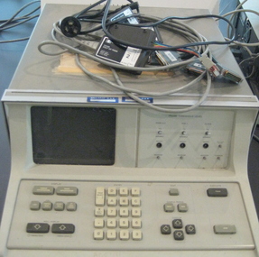
Equipment - Computer - Logic Analyzer, Hewlett Packard, Logic Analyzer 1615a
The Logic Analyser was purchased by the Ballarat College of Advanced Education Physics Department in the early 1980s. At the time it was a state of the art piece of test equipment used for fault finding and programming diagnostics for 8 bit computers. It was later used by the Electrical Engineers, after Physics merged with Engineering in the mid 1990s. The device monitored the 16 bit Address buss and 8 bit Data buss of an 8 bit computer. This device continually samples the 24 bits simultaneously and looks for a preset pattern. When the pattern is matched the logic analyser continues for a set number of steps thus allowing an operator to examine the data and address information both leading up to and after an event. This was particularly useful for diagnosing unusual programming and hardware errors. Logic analyzers are used in debugging and troubleshooting in mini- and microcomputers. The HP analyzers collect information through 24 (1615A) or 32 (1610B) inputs leads, connected to the computer's address, data and/or control lines. The logic state flow is shown on a display in a number of traces, a single data line or an appropriate combination of data lines providing a trigger signal. Captured data can be stored for detailed analysis. (http://http://www.science.uva.nl/museum/hp1610.php)Grey Analog computer. Includes keys and small screen.computer, logic analyzer, physics -
 Chiltern Athenaeum Trust
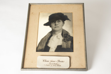
Photograph
Clara Jane Matthews was born in 1870 as the eldest daughter of Robert Matthews. She married William Frederick Busse on the 5th of December, 1894 at St Columb’s church, Hawthorn. Clara and her husband lived on Main Street in Chiltern, and her husband was a Clerk of Courts in Chiltern and Wodonga throughout his life. Clara and William also owned a 640 acre farm called Clairedale Park, four miles (6.5km) outside of Barnawartha. They had both crops and sheep on the property, and adopted innovative farming practices. It appears that Clara was heavily involved in the farm business, as she is listed as a purchaser of sheep in multiple stock reports between 1914 and 1918. This is very unusual for the era, as women were not generally involved in stock markets, especially if her husband was still alive. Clara’s husband’s work at the court likely meant that he wasn’t able to travel to the markets in order to purchase stock. Clara’s taking the reigns in this manner was highly unusual, and signals just how strong of a woman she must have been. Clara Busse died in Chiltern in 1968, when she was 98 years old. She is also the mother of Wilfred C Busse, who was an author and a member of the Chiltern Athenaeum. This photograph is of a woman who lived most of her life in Chiltern, and undoubtedly contributed to the community of the town within her 98 years. She will most likely be remembered as the wife of William Frederic Busse, Clerk of Petty Sessions, or as the mother or Wilfred Clarence Busse, author and barrister. Although the records of her time almost entirely connect her with the men of her life, her father, husband and then her son, some digging can reveal that she was an entire person of her own, who broke norms of her time and is worthy of being remembered for her own sake.Black and white rectangular photograph printed on matte photographic paper mounted on board in a textured metallic frameObverse: Clara Jane Busse / (nee Mathews) / Mother of W. C. Busse / clara jane busse, clara busse, c j busse, busse, women in agriculture, remarkable women, 20th century women, women's history, working women, wilfred busse, wilfred clarence busse -
 Forests Commission Retired Personnel Association (FCRPA)
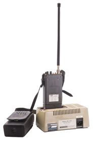
Portable UHF Radio - Sawtron / Kyodo, c 1980s
After the 1939 bushfires, the Forests Commission invested heavily in a radically new communications network. After suffering some inevitable delays due to the War, radio VL3AA switched into full operation in October 1945 proudly beaming out 200 watts across the State. But by today’s standards, the technology was primitive and the reception poor unless the user was on a high point somewhere. The radio signal was "line-of-sight" and bounced between fire towers and relay transmitters across the mountains back to the District offices. Rapid improvements in technology led to various models of bulky handheld portables with heavy batteries that always seemed to go flat. In fact, batteries were a constant impediment at bushfires. The more secure and versatile State Mobile Radio (SMR) digital trunk system came into operation in about 1995. Upgraded Tait Radios were purchased in 2014 after recommendations of the 2009 Bushfires Royal Commission. But it was the convergence of separate technologies such as 4G mobile phones, high-capacity and light-weight lithium batteries, Wi-Fi, the ever-expanding internet, cloud data storage, digital cameras, GPS, personal organisers and hundreds of supporting Apps into powerful smartphones and tablets which revolutionised bushfire communications from the mid-2000s.Portable UHF Radio with leather carrying case and strap. Charging station. Kyodo Model KC-1109 MOYHU Whitfieldbushfire, radios, forests commission victoria (fcv) -
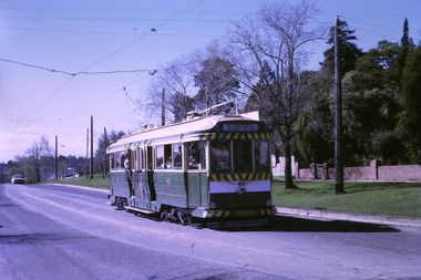
 Ballarat Tramway Museum
Slide - Set of 9, Warren Doubleday, Ballarat - last weekday of full operations, 20/8/1971
Photos taken on the last weekday of full operations by the SECV in Ballarat prior to the first closure of the Victoria St line on 22/8/1971. 1 - trams 33, 13, 30, and 12 in the City loop. Has the Dickins food store, Thomas Jewellers, Gear Chemist, Patersons stores in the view. 2 - tram 37 running a Special passing the trams above in the City Loop. Also has the Hartley's and the T& G buildings in the view. 3 - tram 27 descending the Lydiard St hill about to pass the Titanic Bandstand. 4 - tram 35 turns from Sturt St into Lydiard St north with the Town Hall in the background. 5 - tram 27, Victoria St inbound in Wendouree Parade near Haddon St. Has the tram stop shelter in the view. 6 - tram 39 climbing the Lydiard St North hill. 7 - tram 32 in bound in Sturt St west passing a 40mph speed limit sign. 8 - trams 21 and 34 crossing at the Grant St loop on the Mt Pleasant line. 9 - tram 37 inbound in Lydiard St North with the Ballarat Station building in the background and the signal gantry.Yields information about the last full week day of SEC Tramway operations in Ballarat and has a strong association with the archivist. Set of 9 Kodachrome colour slides - cardboard mountsHave the photographer's slide numbers written on them.trams, tramways, closure, sturt st, lydiard st, tram 13, tram 30, tram 12, tram 37, tram 43 -
 Bendigo Historical Society Inc.
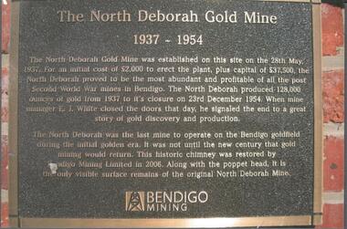
Photograph - NORTH DEBORAH GOLD MINE BENDIGO MINING PLAQUE
Metal plaque, gold writing, erected at the site of the former North Deborah Gold Mine when the brick chimney was restored by Bendigo Mining NL. The plaque reads: 'The North Deborah Gold Mine, 1937-1954. The North Deborah Gold mine was established on this site on the 28th May 1937. For an initial cost of 2,000 pounds to erect the plant, plus capital of 37,500 pounds, the North Debnorah proved to be the most abundant and profitable of all the post Second War mines in Bendigo. The North Deborah produced 128,000 ounces of gold from 1937 to its closure on 23rd December 1954. When mine manager E.J. White closed the doors that day he signaled the end to a great story of gold discovery and production. The North Deborah was the last mine to operate on the Bendigo goldfield during the initial golden era. It was not until the new century that gold mining would return. This historic chimney was restored by Bendigo Mining Limited in 2006. Along with the poppet head. It is the only visible surface remains of the original North Deborah Mine.' The mine site is situated off Breen Street in Golden Square.Kay MacGregor 2012bendigo, mining, north deborah mining company -
 National Vietnam Veterans Museum (NVVM)
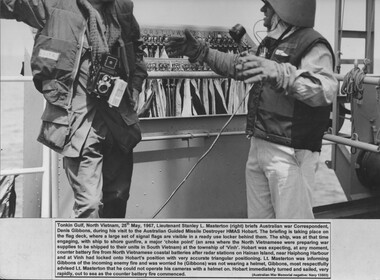
Photograph, Briefing Denis Gibbons
A black and white photograph of Tonkin Gulf, North Vietnam 25th May 1967 Lt Stanley L Masterton briefs Australian War Correspondent, Denis Gibbons, during his visit to the Australian Guided Missile Destroyer HMAS Hobart. the briefing is taking place on the flag deck, where a large set of signal flags are visible in a ready use locker behind them. the ship, was at that time engaging, with ship to shore gunfire, a major "choke point" (an area where the North Vietnamese were preparing war supplies to be shipped to their units in South Vietnam) at the township of "Vinh". Hobart was expecting, at any moment, counted battery fire from North Vietnamese coastal batteries after radar stations on Hainan Island, Near Haiphong Harbour and at Vinh had locked onto Horart's position with very accurate triangular positioning. Lt Masterton was informing Gibbons of the incoming enemy fire and was worried he (Gibbons) was not wearing a helment, gibbons, most respectfully advised Lt Masterton that he could not operate his cameras with a helmet on. Hobart immediately turned and saled, very rapidly, out to sea as the counter battery fire commencedAustralian War memorial negative: Navy 13503photograph, hmas hobart, lt stanley l masterton, denis gibbons, vinh, hainan island, haiphong harbour, gibbons collection catalogue -
 Flagstaff Hill Maritime Museum and Village
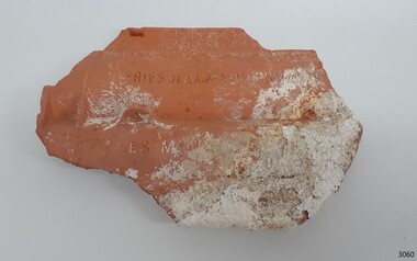
Ceramic - Roof Tile, Circa 1914
The Italian barque Antares was an iron three-masted sailing clipper built in 1888 by Russell & Co of Port Glasgow originally named the “Sutlej” and renamed in 1907 the “Antares” when sold to the Semider Bros of Genoa Italy. The vessel left Marseilles on the 18th of December 1913 with its master captain Gazedo destined for Mullaly & Byrne of Melbourne with a cargo of roof tiles but failed to arrive. The wreckage was found near the Bay of Islands twenty-two miles east of Warrnambool after a body had washed ashore. Some of the timbers washed up were charred by fire, and a small boat's stern board with the name "Sutlej" led to the identification of the wreck as Antares which had been reported missing. According to later reports, the Antares wrecking was overshadowed by war news at the time. A young local boy had remarked that the Germans had arrived off the coast as he had seen them firing off shells and rockets, but his story was passed off as a joke. These rockets were most likely the distress signals from the stricken ship. The Italian barque/clipper Antares was sometime later reported as overdue. The wreck of the ship was later found at the base of a cliff at the Bay of Islands near Warrnambool in November 1914, there were no survivors.The Antares is significant as it was a sail trader carrying an international inbound cargo during the early part of the 20th century. It is part of the Great Ocean Road Historic Shipwreck Trail and as such is registered as a protected wreck in the Victorian Heritage Database VHS S34 .Roof tile; clay terracotta roof tile. Inscriptions are impressed into the clay. It was recovered from the wreck of the Antares. ”- E R I E S DE LA MEDITERRANEE” “ … T S – MI-LES BOU- R …..” SYMBOL [Sideways crown or tree (could be TULLERIES DE LA MEDITERRANEE)]flagstaff hill, warrnambool, flagstaff hill maritime museum, maritime museum, shipwreck coast, flagstaff hill maritime village, great ocean road, roofing tile, building materials, antares, peterborough, 1914 shipwreck, sutlej, antares rock., bay of islands, terracotta tile, clipper -
 Puffing Billy Railway
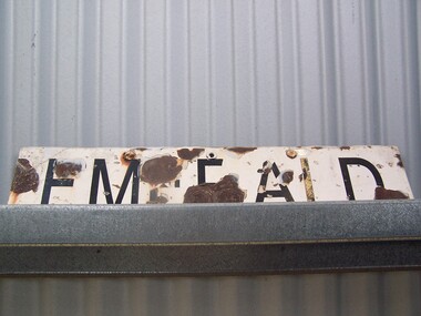
Emerald Station Sign
Station Sign - Emerald Emerald Station is situated on the Puffing Billy Railway in Victoria, Australia. It was opened with the Railway on 18 December 1900 and comprised a platform track and a loop siding. A passing loop was added between the two a few years later. There was also a spur siding off the Down end of No. 3 Road. Two standard 12 ft by 20 ft timber portable station buildings with a Van Goods Shed between (all adjoining) were provided on the platform and a Goods Shed on the No. 3 Road loop siding. Other buildings included Tea Rooms, lamp room and toilets along with a cattle race and loading bank. The station building was later reduced in length by one of the portables which housed the General and Ladies' waiting rooms. Emerald today remains very similar to the early days, but has had other Roads added into a Carriage Workshops, a turntable and storage sidings. Also, a Signal and Telegraph Branch depot in the form of a large Goods Shed and a multi-purpose yard building in the form of a Locomotive Depot administration building have been added. During 2009, the station building underwent stage one of an internal restoration to its former glory. ref: https://en.wikipedia.org/wiki/Emerald_railway_station,_Victoria photos at http://www.vicrailstations.com/Gembrook/Emerald/Emerald.html Historic - Victorian Railways Station sign used at Emerald Station Station Sign - Emerald Metal rectangle Station Name Sign with white enamel back ground and black lettersEmeraldstation sign, puffing billy, emerald station -
 Ballarat Tramway Museum
Photograph - Digital image Set of 9, Tony Smith, 19/09/1971 12:00:00 AM
Yields information about Ballarat Tramways and trams prior to the closure of the tramway system.Set of 9 digital images of Ballarat trams prior to closure, scanned from original slides by Tony Smith, 1971 prior to closure of the system. This set of slides appears to be the last day of operations - 19/9/1971 .1 - 40 south bound in Lydiard St Nth, at the Gregory St Loop. .2 - 40 after passing through the loop .3 - 42, north bound in Lydiard St. North at Macarthur St. .4 - 42 southbound at the Railway station level crossing with the Kennedy Murray Pty Ltd General Carriers building at the station yard in the background. .5 - 42 southbound in Lydiard St North after crossing the railway - taken from the signal box (B) with Reids Palace in the background and the Provincial Hotel. .6 - 35 northbound after passing through the level crossing. .7 - bogie tram crossing the tracks with Ballarat Railway Station in the background. .8 - bogie tram entering the double track section in Lydiard St with Reids Palace in the background. Note the new bus stop bay. .9 - 35 and another bogie in Sturt St, with the Town Hall, Golden Star Chinese Cafe and Georges Fish & Chip shop in the background.trams, tramways, lydiard st nth, gregory st, level crossings, ballarat railway station, sturt st, closure, tram 40, tram 42, tram 35 -
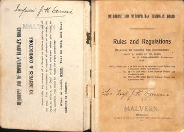 Melbourne Tram Museum
Book, Melbourne & Metropolitan Tramways Board (MMTB), "Melbourne and Metropolitan Tramways Board - Rules, Regulations", 1924
Book - dark grey Rexene covers, with title - "Melbourne and Metropolitan Tramways Board - Rules, Regulations". Two sections, stapled and bound within heavy card covers, 80 pages with a typed index pasted inside rear covers, printed by Sands & McDougall, Melbourne. Authorised by W. O. Strangward Secretary 1923 and printed 1924. On first page, has number "6246" stamped onto the page. Provides the Rules and Regulations of the Board concerning Accidents, fire, general instructions, signals, uniforms, staff working, special instructions to Motormen and Conductors, tickets, safety for both Cable and Electric tramways. By-Law No. 5 provided on pages 76 to 80. On page 80 has the Seal of the Board and those who signed the document - Alex Cameron Chairman, Thos. O'L Reynolds Member and W. O. Strangward Secretary. Inside rear cover is a 12 page typed index to the rules in broken into sections for each letter of the alphabet - pages for M to O missing. Extract re Staff and ticket rules added 19-12-16 - see image i7. 2nd copy added 18-01-2022 Images revised - scanned in two parts. Copy No. 18812nd copy has "Inspector J H Cowrie" written on the inside front cover, 1st page and inside rear cover. Stamped "Malvern" in two locationstrams, tramways, mmtb, melbourne, cable trams, rules, regulations, safeworking -
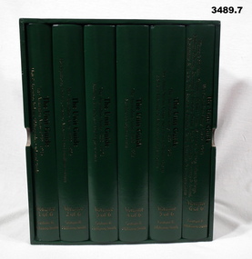 Bendigo Military Museum
Book - BOOKS, BOXED SET, Graham R McKenzie - Smith, The Unit Guide, 2018
.1) Box open, cardboard, dark green buckram, white paper lining, gold print on sides. .2) - .7) Hard cover book, cardboard, dark green buckram with gold print on front cover & spine. Pages are plain, cut, white, black print, black & white illustrations. .2) Volume 1 of 6. Unit & Location Indexes / Bibliography, Orders of Battle. 483 pages. .3) Volume 2 of 6. Headquarters, Infantry, Cavalry / Armoured & Intelligence Units. 605 pages. .4) Volume 3 of 6. Artillery, Air Defence and Engineer Units. 626 pages. .5) Volume 4 of 6. Medical and Signal Units. Box of 6 books. The Unit Guide / The Australian Army / 1939 - 1945. 654 pages .6) Volume 5 of 6. Aust Army Service Corps, Aust Army Ordnance Corps and Aust Electrical & Mechanical Engineer Units. 706 pages. .7) Volume 6 of 6. Womens Services / Volunteer Defence Corps / War Graves, Survey, Labour, Salvage / Military Policing / Recruiting & Training / Dental, Bath & Laundry / Veterinary & Animal / Movements & Transit / Pay, Records & Printing, Postal / Amenities & Canteens Units. 568 pages. books- military history, unit guide -
 Flagstaff Hill Maritime Museum and Village
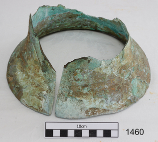
Bell, Before 1837
This remnant of a ships bell was recovered from the wreck site of the CHILDREN by Flagstaff Hill Divers on 1 October 1973. (Diving identification number S.M24/10-73, Accession number 24). The artefact had lain in the ocean off Childers Cove since the vessel’s disastrous sinking there on 15 January 1839. Other similarly high value metallic objects raised from the site, and now in the Flagstaff Hill collection, are the ship’s signal cannon (1963), and the ship’s anchor (1974). A ship’s bell was normally struck by the lookout at the foreward part of a vessel, following orders (“Strike the bell”) from the officer of the watch at the helm, or as a warning signal of danger ahead. Its main function was to keep the crew aware of time. Each 24 hour period was divided into 4 hour work-shifts, or watches, and each of these was divided into 8 half hours, or glasses (each half hour being determined by the time it took between each turn of the ship’s hourglass). The six watches were the first watch from 8pm to midnight, the second or middle watch from midnight to 4am, the third or morning watch from 4 to 8am, the fourth of forenoon watch from 8am to midday, the fifth or noon watch from midday to 4pm, and the sixth or dog watch from 4 to 8pm. Within each watch the first half hour would end with one bell, the second with two bells, the third with three bells, and so on until their work-shift ended with the ringing of eight bells. The CHILDREN left Launceston on 11 January 1839 and immediately struck heavy weather. By the evening of 15 January Captain Browne had been continuously on duty for 4 days and needed sleep, his First Mate (T. Gay) was incapacitated with seasickness, and the task of command was given to the Second Mate (W. Wentworth). At two bells into the first watch, or 9 o’clock that night, the captain went below. Two hours later, at six bells into the first watch, or 11 o’clock that night, the lookout cried “Breakers close ahead”. Within a minute the ship struck the rocks at the entrance of Childers Cove. Within twenty minutes the huge seas had taken her stern, three masts and much of her weatherside, leaving survivors clinging to the forecastle. Within two hours the wreck had completely disappeared. If anyone could have rung the bell by then, it would have been to strike two bells into the middle-watch, or one o’clock on the morning of 16 January. An 1859 Victorian Register of Wrecks from 1835 to 1858 remarks the CHILDREN “Ran ashore through an error in the reckoning and a bad lookout [and] Became a total wreck”. 22 passengers and crew survived the tragedy, but 16 lives were lost, including the captain and second mate, and 8 children. The shipwreck of the CHILDREN is of State significance ― Victorian Heritage Register S116A part of a brass ship’s bell, recovered from the wreck of the CHILDREN. The upper part, or dome of the bell, has corroded away, leaving the lower portion, or mouth of the bell, largely intact. However this lower surviving portion has been severed vertically with a clear (saw?) cut, leaving a regular 1cm gap down one side of the bell. It is an evocative relic, attractively aged on the seafloor, bearing layers of aqua-marine verdigris and white limestone accretion on a dull bronze surface. There is no visible ship’s name on the bell. flagstaff hill, warrnambool, shipwrecked coast, flagstaff hill maritime museum, maritime museum, shipwreck coast, flagstaff hill maritime village, great ocean road, the children, bell, ships bell, childers cove, henty brothers, james henty & co, sea-watches, nautical time, james henty & co, bell from the children -
 Glen Eira Historical Society
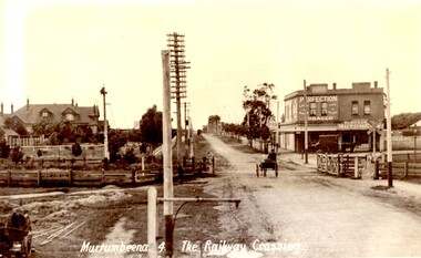
Article - MURRUMBEENA ROAD RAILWAY CROSSING
This file contains eleven items: 10 original photographs and 1 newspaper cutting. 1/A black and white photograph titled in the format of the shot ‘Murrumbeena. 4. The Railway Crossing’, date unknown, estimated to be 1905. Donated by the Hermes Studio on 19/11/1980. 2/A black and white photograph with a white border of the signal box at Murrumbeena Station by R.P Dunbar dated 16/03/1979 with a handwritten description on the back. 3/A black and white photograph with a white border of the interior of the Murrumbeena Train Station Signal box with a man identified as Michael sitting, taken by R.P Dunbar dated 17/03/1979 with a handwritten description on the back. 4/A black and white photograph with a white border of the removal the boom gates at Murrumbeena Train Station railway crossing. Taken by R.P Dunbar printed 28/04/1979, which includes a handwritten description on the back. 5/A black and white photograph with a white border of the removal of the boom gates taken by R.P Dunbar dated 29/04/1979, with a handwritten description on the back. 6/A black and white photograph with a white border of Murrumbeena Road Crossing during the removal of the boom gates taken by R.P Dunbar printed 29/04/1979. This includes a hand written description on the back. 7/A black and white photograph with a white border of the Murrumbeena Road Railway Crossing during the removal of the boom games dated 29/04/1979, taken by R.P Dunbar, with a hand written description of the photograph on the back. 8/A black and white photograph with a white border of Murrumbeena Road Crossing during the removal of the boom gates dated 29/04/1979 taken by R.P Dunbar with a handwritten description on the back. 9/A black and white photograph with a white border of Murrumbeena Road Railway Crossing with a new boom barrier replacing the boom gates, taken by R.P Dunbar dated 29/04/1979. Including a handwritten description on the back. 10/A black and white photograph with a white border of Murrumbeena Railway Station, Murrumbeena Road with the replacement boom barriers in place, taken by R.P Dunbar dated 29/04/1979. Including a hand written description on the back. 11/A newspaper article titled ‘Boom gates to create road Chaos’ written by Adam Carey from ‘The Age’ dated 29/11/2011. This includes a coloured photograph of the Murrumbeena Road Level Crossing taken by Michael Clayton Jones, and a map of the train line and level crossing between Carnegie Station and Hughesdale Station. The article makes educated predictions based on VicRoads Studies of future implications on road traffic unless more level crossings are removed. In particular the Dandenong corridor and Murrumbeena Road crossings are identified as high priority on the list of potential crossings which may have to be removed. Additionally the article discusses options the government has in addressing the dilemma, and the opinion of a Carnegie pharmacist Gerald Galatis whose business is near the level crossing on Koornang Road.transport, railway crossing, koornang road, railways, level crossing, gates, trains, road crossing, transport establishments, signal boxes, murrumbeena railway station, dunbar r.p., murrumbeena road, carnegie station, railway lines, railway buildings, road traffic, galatis gerald, construction sites, poath road, neerim road, hermes studio -
 Bendigo Military Museum
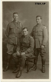
Postcard - POSTCARDS, PHOTOGRAPHIC WW1, Edgar Dawson collection : Battalion comrades
This six-postcard group is the second in a series of records of items in the collection of Edgar Dawson DCM. Dawson was the Regimental Sergeant Major of 57th Battalion, AIF. The 57th had a company of men largely from Bendigo and Eaglehawk. These postcards are from his personal album. Many are annotated in Dawson's hand with explanatory notes on the subject. Refer to Cat No 893 for his service details. Items originally in album cat. no. 207P Service details available through the NAA. Collection of six black and white postcards: 1. Photographic portrait from left William George Saville 4182, Alexander Pollock 3587 57th Btn, and unidentified trooper, possible 4th Light Horse Regiment. 2. Photographic portrait of Light Horse trooper. 3. Photographic portrait of William Tamlyn Curnow, 5078, 57th Btn 4. Photographic portrait of "Jim", 5. Photographic portrait of Septimus Fletcher, 4485, 57th Btn 6. Photographic portrait of Robert Gamble, 4644, 57th Btn 2. Card is addressed to "1904 L.Cpl W.W. Martin, D Cpy 57th Batt". Martin was 2150, KIA 26th September 1917. 3. On front "Sincerely, W. T. Curnow". On verso, "To Hec, from his old pal Curnow Sgt" 'Hec' was Dawson's nickname. 4. On front "Yours sincerely Jim". On verso, card addressed "350 Pte Melen, R. C., 15th Field Ambulance, via Manners St Maryborough Victoria" The 15th Field Ambulance Cpy, supported the 57th and other battalions of the 15th Brigade. 5. On verso "This is an Eaglehawk boy Septimus Fletcher, he came over with me and was with us a long time, but is on Division now" 6. On verso "This is our signal Cpl wearing his military medal for keeping communication at Bullecourt". Gamble won the MM for his actions 13th May 1917.57th battalion, postcards, album dawson dcm, edgar dawson dcm -
 The Beechworth Burke Museum
Photograph, Unknown
The A1 Gold Mine is located north of Woods Point, near Jamieson, in the Upper Goulburn region of Victoria. Gold was discovered at the A1 site in 1861 and mining operations began in 1864. The A1 Mine Settlement refers to a small township known variously as Castle Reef, Castle Point, and Raspberry Creek, which developed in the 1860s around mining industry centred on a crushing machine that worked the three gold reefs in the area. Historically, the name "A1"referred to the high quality of gold found in the quartz reefs at depths of at least two thousand feet. Along with the Morning Star mine at Woods Point, the A1 gold mine produced almost sixty percent of Victoria's gold output in the 1950s to 1970s and continued operating until 1992 when it went into administration. Operations at the site were revived in 2016 and the A1 Mine is now considered one of Victoria's premier gold mines. The A1 mine is part of the extensive and prospective Lachlan Fold Belt, a north-west trending belt of tightly folded Early Devonian sedimentary rocks extending from New South Wales to Victoria. Mineralisation is hosted within or immediately adjacent to diorite dykes. Contemporary development of the 'Queens Lode' at the A1 mine signals a move from high-grade, narrow vein airleg mining into larger scale, mechanical mining designed to increase ore production volume. This original, undated photograph of the A1 Mine appears to depict an area or phase of disuse or abandonment. The aged and humble appearance of the cottage suggests association with the historical A1 Mine Settlement, therefore the image may have been taken prior to the 1950s-1970s revival period in which the A1 mine is known to have produced high gold yields. The photograph contributes to our understanding of the A1 Gold Mine's impact on the landscape and the social, environmental impacts of mining on communities and may be compared with others in the Burke Museum's extensive collection of mining photographs to deepen our understanding of mining in the Jamieson area.Black and white rectangular photograph printed on photographic paperReverse: 5577 / A1 Mine / Near Jamieson / Vic. /burke museum, beechworth museum, beechworth, gold fields, gold rush, victorian gold rush, mining tunnels, gold ming history, colonial australia, australian gold rushes, mining technology, beechworth historic district, indigo gold trail, indigo shire, upper goulburn shire, jamieson, woods point-walhalla goldfield, a1 gold mine, victorian high country, modern mining methods, orogenic gold province, gold mineralisation, devonian, dykes -
 Flagstaff Hill Maritime Museum and Village
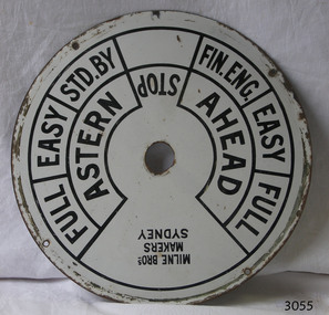
Equipment - Ships' Telegraph section, Milne Brothers, Copper and Brass Works, Early-to mid-20th century
This Engine Room section of a ship's telegraph system was part of the equipment of the Ports and Harbour ship the SS Rip. The vessel serviced and maintained the lights and buoys at Port Phillip Bay and Queenscliffe. The SS Rip was possibly the former gunboat "Albert". The ship’s communication system that was used from the late 19th century to early-to-mid-20th-century is called an Engine Order Telegraph (E.O.T.) or ship’s telegraph. The system has two parts, the Bridge Section and the Engine Room Section. The Bridge Section is usually mounted on top of a pedestal, and the Engine Room Section is often attached to a vertical surface. The standard commands printed or stamped onto the dial are the directions of AHEAD and ASTERN, and the speeds of STOP, FULL, EASY, STD. BY. and FIN. ENG. The ship’s pilot on the Bridge of a vessel sends his Orders for speed and direction to the to the Engine Room with the E.O.T. He moves the lever or levers, depending on the number of engines the ship has, to change the indicator on the Bridge Section’s dial to point in the new direction and speed of travel. This change causes the Orders to be duplicated on the Engine Room Section’s dial and a bell to signal the change simultaneously. The engineer then adjusts the ship’s engines and steering equipment to follow the pilot’s Order. The manufacturer, Mulne Bros., was a copper and brass works at 166 Sussex Street Sydney, in December 1892, and previously from 1870 at 128 to 130 Sussex Street. The company made and sold a wide range of equipment including machinery and gauges for the Railways.The Engine Room section is significant for being part of the communications system on the ship SS Rip, owned by Melbourne's Ports & Harbours department and used to service and maintain the navigation signals of Port Phillip Bay and at Queenscliffe in the mid-20th century. The dial is an example of marine equipment made in Australia and used for the safety of Victorian vessels. It is also significant for being made by an early Australian manufacturer, Milne Brothers of Sydney.Engine Room Section of a ship’s telegraph or Engine Order Telegraph (E.O.T.). The round metal dial has inscriptions stamped around the edges. The inscriptions are nautical terms for direction and speed and include the maker’s details. The dial was made by Milne Bros. of Sydney. It was part of the equipment on the "SS Rip" in Victoria.Black paint around dial: "MILNE BROS. / MAKERS / SYDNEY" "FULL EASY STD. BY " "FIN ENG. EASY FULL" ""ASTERN" "STOP" "AHEAD"flagstaff hill, warrnambool, maritime museum, maritime village, great ocean road, shipwreck coast, marine technology, marine communications, engine order telegraph, e.o.t., ship’s telegraph, bridge section, engine room section, ship’s engine telegraph section, marine telegraph, milne bros., milne brothers, sydney, copper and brass works, ports & harbours ship, ss rip, gunboat albert, service ship, maintenance ship -
 Kiewa Valley Historical Society
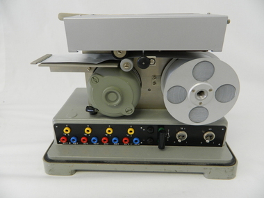
Timer Favag, Circa 1950
This Favag Timer apparatus was a part of the first electronic control system -(1960's), in Victoria), which worked using telephone stepping selectors to convey a change in voltage providing a regulated pulse from the control centre(Mount Beauty) to the remote Power Stations opening and closing (stop/start) of various devices at the Power Station and a return signal confirmed the action taken. Testing of this unit was carried out using a "dummy" device at the remote Power Station so as not to disrupt the power plant's operation. This timer was one of many electrical apparatus connected to the large SEC Victoria Hydro Scheme's electrical power producing generators. These generators are powered by the hydro force of "stored" water at a higher altitude. The establishment of both the NSW and Victorian Hydro Schemes was achieved from the early 1900's to the 1960's. At this point in time the need for additional power sources to quench both an industrial and domestic demand for electricity was purely an economic and not and environmental (carbon reduction) factor. This hydro scheme was instigated by "the Government of the day" as a bold move and was the major force of the World War II refugee and "technical" workforce,inclusion of skilled and unskilled, migration into the Australian environment. Although this mass "invasion" of workers with families was thought of in some circles as intrusive, the expansion of population post war years and its integration into the Australian rural sector, produced the multi- lingual multi-cultural diversity of later years.This Favag Timer was one of the crucial pieces of equipment that made it possible for the Mount Beauty Terminal Station to control the operations of these Power Stations; McKay, Clover, West Kiewa Power Stations and the Dederang Terminal Station.This aluminium and anodised "FAVAG" (pulse) timer is fastened to a base structure which comes with its own metal cover that is fastened by two metal hooks. From the top of these hooks runs a thick leather "carry" strap.The instrument, itself, a small "micro motor" at one end tape feeding spool on the other. Aluminium metal structures offer a preventative barrier against any electronic spikes from static electricity sources. There are two toggle switches to the bottom right hand side and twelve coloured "pin" connection points.There is a sliding access sleeve which exposes a circuit board.with various leads fastened on each side. In front of one of this slide are two "screw in" fuses, spare fuses are in a small envelope taped above. Circuit diagrams are etched white on black background on the top face of the main structure. At the base of the back section is a two pronged input terminal. There is a fine black rubber layer (cushioning) for the mian top cover.On the cover fastened with two rivets "FAVAG" underneath in small print "Fabrique d'appareils electriques S.A." underneathe "NEUCHATEL-SUISSE". on one end is a "STATE ELECTRICITY COMMISSION OF VICTORIA" metal label screwed on.The back label has manufacturers' type and model number.sec vic kiewa hydro scheme, alternate energy supplies, alpine population growth -
 4th/19th Prince of Wales's Light Horse Regiment Unit History Room
Medal
Title Peace of 1919 medalet issued to Australian schoolchildren Object type Medalet Place made Australia: Victoria, Melbourne Date made 1919 Summary Designed by C Douglas Richardson, 'The Peace of 1919' medalet was issued by the Defence Department to school children throughout Australia to commemorate the signing of the Versailles Peace Treaty in 1919. The medals were originally suspended from a narrow piece of red, white and blue striped cotton ribbon. This medalet is associated with one of the children of Lance Corporal Giles Daniel, 1st AIF. Born in Ballarat, western Victoria on 16 December 1870, Giles Felix Daniel moved to Oakleigh, Victoria aged 15. A member of the Victorian permanent forces, he served as a corporal (regimental number 8) with the First Victorian Mounted Infantry Company, part of the first Victorian Contingent to the war in South Africa in 1899. This unit was one of the first Australian formations to see action during the Boer War. It was largely drawn from serving members of the Victorian forces. Demoted to private following a Court Martial on 19 November 1900, Daniel returned to Australia in December of the same year. During the First World War, he was again one of the first to enlist, joining the AIF on 19 August 1914, and becoming Lance Corporal number 32 with the First Divisional Signals Company. He served with this unit during the Gallipoli campaign and until his return to Australia on 11 April 1916. Silver-plated brass Circular medalet with a plain edge and integral suspension loop. The obverse features a symbolic female figure of Peace, holding a sword and standing on a plinth marked 'PEACE 1919'. Behind her flies a dove, and at her left and right feet are two figures freed from their shackles. The reverse features a central panel surrounded by laurel leaves, surmounted by the King's Crown with the word 'VICTORY' over the rays of the rising sun. A sailor and a digger stand at ease on either side of the panel on which is cast 'THE / TRIUMPH / OF / LIBERTY / AND / JUSTICE'. Below the leaves is a very small panel with the words 'THE PEACE OF 1919' and the manufacturer's name.peace medal 1919 -
 Flagstaff Hill Maritime Museum and Village
Functional object - Porthole Frame, Russell & Co, 1888
This portion of the porthole frame was part of the fittings of the Antares. The Italian barque “Antares” was an iron three-masted sailing ship built in 1888 by Russell & Co of Port Glasgow. The ship was originally named the “Sutlej” but was renamed the “Antares” in 1907 when sold to the Semider Bros of Genoa, Italy, where it was registered. The vessel left Marseilles on the 18th of December 1913 with its master Captain Gazedo destined for Mullaly & Byrne of Melbourne with a cargo of roofing tiles but failed to arrive. The wreckage was found near the Bay of Islands, twenty-two miles east of Warrnambool, after a body had washed ashore. Some of the timbers washed up were charred by fire, and a small boat's stern board with the name "Sutlej" led to the identification of the wreck as Antares, which had been reported missing. According to later reports, the Antares wrecking was overshadowed by war news at the time. A young local boy had remarked that the Germans had arrived off the coast as he had seen them firing off shells and rockets, but his story was passed off as a joke. These rockets were most likely the distress signals from the stricken ship. The Italian barque, clipper, Antares was sometime later reported as overdue. The wreck of the ship was later found at the base of a cliff at the Bay of Islands near Warrnambool in November 1914; there were no survivors.The Antares is significant as it was a sail trader carrying international inbound cargo during the early part of the 20th century. It is part of the Great Ocean Road Historic Shipwreck Trail and as such is registered as a protected wreck in the Victorian Heritage Database VHS S34 .Porthole frame section, brass, large part corroded away. Hing is still visible on the end. The underside is shaped to allow the fitting of the glass. Recovered from the wreck of the Antares. Noneflagstaff hill, warrnambool, shipwrecked-coast, flagstaff-hill, flagstaff-hill-maritime-museum, maritime-museum, shipwreck-coast, flagstaff-hill-maritime-village, antares, tall ship, sailing ship, peterborough, phillip le couteur, peter mathieson, constable stainsbury, sutlej, antares rock., bay of islands, porthole, ship fitting, 1914 shipwreck, porthole frame -
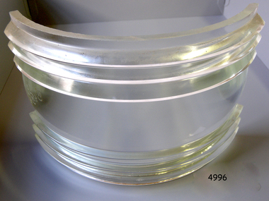 Flagstaff Hill Maritime Museum and Village
Functional object - Fresnel Glass Lens, Early 20th century
A Fresnel lens is a type of composite compact lens developed by the French physicist Augustin-Jean Fresnel (1788–1827) for use primarily in lighthouses. Made from high-quality glass Fresnel lenses were used originally in lighthouses and later for many other applications They were later being used for automobile headlamps, brake, parking, and turn signal lenses, and many other applications. Fresnel lenses used in lighthouses were considered state of the art from the late 19th through to the middle of the 20th century. The subject item is a Fresnel replacement lens used in a ships navigation light. For lighthouses, these lenses have now been replaced with much less expensive and more durable aerobeacons, which themselves often contain plastic Fresnel lenses. The lens design allows the construction of lenses of large aperture and short focal length without the mass and volume of material that would be required by a lens of conventional design. A Fresnel lens can be made much thinner than a comparable conventional lens, in some cases taking the form of a flat sheet. The simpler dioptric (purely refractive) form of the lens was first proposed by Count Buffon and independently reinvented by Fresnel. The catadioptric form of the lens, entirely invented by Fresnel, has outer elements that use total internal reflection as well as refraction; it can capture more oblique light from a light source making the light visible from greater distances.The subject item at this time cannot be associated with a historical event, person or place, provenance is unknown, the item is a replacement for a ships navigation light and it is believed to have been produced before 1950.Fresnel glass replacement lens for a navigation side lamp of a ship. W.T.G (S) and 10x7 S.STR.ENGL.125warrnambool, flagstaff-hill, flagstaff-hill-maritime-museum, maritime-museum, shipwreck-coast, flagstaff-hill-maritime-village, fresnel lens, maritime light, ships navigation light, augustin-jean fresnel, lighthouse lenses, lighthouse, navigation, warning light -
 Flagstaff Hill Maritime Museum and Village
Ceramic - Roof Tile, Circa 1914
This portion of terracotta roof tile was salvaged from the wreck of the Antares by Flagstaff Hill diver, Peter Ronald. It has letters, numbers and symbols impressed into the clay by the manufacturer. The Italian barque Antares was an iron three-masted sailing clipper built in 1888 by Russell & Co of Port Glasgow originally named the “Sutlej” and renamed in 1907 the “Antares” when sold to the Semider Bros of Genoa Italy. The vessel left Marseilles on the 18th of December 1913 with its master captain Gazedo destined for Mullaly & Byrne of Melbourne with a cargo of roof tiles but failed to arrive. The wreckage was found near the Bay of Islands twenty-two miles east of Warrnambool after a body had washed ashore. Some of the timbers washed up were charred by fire, and a small boat's stern board with the name "Sutlej" led to the identification of the wreck as Antares which had been reported missing. According to later reports, the Antares wrecking was overshadowed by war news at the time. A young local boy had remarked that the Germans had arrived off the coast as he had seen them firing off shells and rockets, but his story was passed off as a joke. These rockets were most likely the distress signals from the stricken ship. The Italian barque/clipper Antares was sometime later reported as overdue. The wreck of the ship was later found at the base of a cliff at the Bay of Islands near Warrnambool in November 1914, there were no survivors.This tile is significant in its association with the wreck of Antares and is registered as a Shipwreck Artefact A/2. This tile is significant for its association with the sailing ship Antares, one of the last of the 'tall ships' to be lost along the southwest coast of Victoria, and the only wreck that took the lives of all people on board. The significance is recognised by its listing on the Victorian Heritage Register VHS S34. The Antares is significant as a sail trader carrying international inbound cargo. It is part of the Great Ocean Road Historic Shipwreck Trail.Roof tile; terracotta clay tile shaped for fitting together with other tiles. Inscriptions are impressed into the clay. It was recovered from the wreck of the Antares. Impressed text:”- E R I E S DE LA MEDITERRANEE” “ … T S – MI-LES BOU- R …..” Impressed symbol: (Sideways crown or tree) (could be TULLERIES DE LA MEDITERRANEE)flagstaff hill, warrnambool, flagstaff hill maritime museum, maritime museum, shipwreck coast, flagstaff hill maritime village, great ocean road, roofing tile, building materials, antares, peterborough, 1914 shipwreck, sutlej, antares rock., bay of islands, terracotta tile, clipper, roof tile, building material -
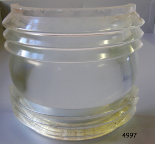 Flagstaff Hill Maritime Museum and Village
Functional object - Fresnel Glass Lens, Early 20th century
A Fresnel lens is a type of composite compact lens developed by the French physicist Augustin-Jean Fresnel (1788–1827) for use primarily in lighthouses. Made from high-quality glass Fresnel lenses were used originally in lighthouses and later for many other applications They were later being used for automobile headlamps, brake, parking, and turn signal lenses, and many other applications. Fresnel lenses used in lighthouses were considered state of the art from the late 19th through to the middle of the 20th century. The subject item is a Fresnel replacement lens used in a ships navigation light. For lighthouses, these lenses have now been replaced with much less expensive and more durable aerobeacons, which themselves often contain plastic Fresnel lenses. The lens design allows the construction of lenses of large aperture and short focal length without the mass and volume of material that would be required by a lens of conventional design. A Fresnel lens can be made much thinner than a comparable conventional lens, in some cases taking the form of a flat sheet. The simpler dioptric (purely refractive) form of the lens was first proposed by Count Buffon and independently reinvented by Fresnel. The catadioptric form of the lens, entirely invented by Fresnel, has outer elements that use total internal reflection as well as refraction; it can capture more oblique light from a light source making the light visible from greater distances.The subject item at this time cannot be associated with a historical event, person or place, provenance is unknown, the item is a replacement for a ships navigation light and it is believed to have been produced before 1950.Fresnel glass replacement lens for a navigation lamp of a ship. None warrnambool, flagstaff-hill, flagstaff-hill-maritime-museum, maritime-museum, shipwreck-coast, flagstaff-hill-maritime-village, fresnel lens, maritime light, ships navigation light, augustin-jean fresnel, lighthouse lenses, lighthouse, navigation, warning light -
 Flagstaff Hill Maritime Museum and Village
Functional object - Fresnel Glass Lens, Early 20th century
A Fresnel lens is a type of composite compact lens developed by the French physicist Augustin-Jean Fresnel (1788–1827) for use primarily in lighthouses. Made from high-quality glass Fresnel lenses were used originally in lighthouses and later for many other applications They were later being used for automobile headlamps, brake, parking, and turn signal lenses, and many other applications. Fresnel lenses used in lighthouses were considered state of the art from the late 19th through to the middle of the 20th century. The subject item is a Fresnel replacement lens used in a ships navigation light. For lighthouses, these lenses have now been replaced with much less expensive and more durable aerobeacons, which themselves often contain plastic Fresnel lenses. The lens design allows the construction of lenses of large aperture and short focal length without the mass and volume of material that would be required by a lens of conventional design. A Fresnel lens can be made much thinner than a comparable conventional lens, in some cases taking the form of a flat sheet. The simpler dioptric (purely refractive) form of the lens was first proposed by Count Buffon and independently reinvented by Fresnel. The catadioptric form of the lens, entirely invented by Fresnel, has outer elements that use total internal reflection as well as refraction; it can capture more oblique light from a light source making the light visible from greater distances.The subject item at this time cannot be associated with a historical event, person or place, provenance is unknown, the item is a replacement for a ships navigation light and it is believed to have been produced before 1950.Fresnel glass replacement lens for a navigation mast headlamp of a ship. Nonewarrnambool, flagstaff-hill, flagstaff-hill-maritime-museum, maritime-museum, shipwreck-coast, flagstaff-hill-maritime-village, fresnel lens, maritime light, ships navigation light, augustin-jean fresnel, lighthouse lenses, lighthouse, navigation, warning light -
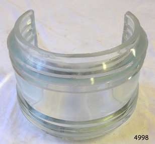
 Flagstaff Hill Maritime Museum and Village
Functional object - Fresnel Glass Lens, Early 20th century
A Fresnel lens is a type of composite compact lens developed by the French physicist Augustin-Jean Fresnel (1788–1827) for use primarily in lighthouses. Made from high-quality glass Fresnel lenses were used originally in lighthouses and later for many other applications They were later being used for automobile headlamps, brake, parking, and turn signal lenses, and many other applications. Fresnel lenses used in lighthouses were considered state of the art from the late 19th through to the middle of the 20th century. The subject item is a Fresnel replacement lens used in a ships navigation light. For lighthouses, these lenses have now been replaced with much less expensive and more durable aerobeacons, which themselves often contain plastic Fresnel lenses. The lens design allows the construction of lenses of large aperture and short focal length without the mass and volume of material that would be required by a lens of conventional design. A Fresnel lens can be made much thinner than a comparable conventional lens, in some cases taking the form of a flat sheet. The simpler dioptric (purely refractive) form of the lens was first proposed by Count Buffon and independently reinvented by Fresnel. The catadioptric form of the lens, entirely invented by Fresnel, has outer elements that use total internal reflection as well as refraction; it can capture more oblique light from a light source making the light visible from greater distances.The subject item at this time cannot be associated with a historical event, person or place, provenance is unknown, the item is a replacement for a ships navigation light and it is believed to have been produced before 1950.Fresnel round glass masthead replacement lens for a navigation lamp of a ship. Nonewarrnambool, flagstaff-hill, flagstaff-hill-maritime-museum, maritime-museum, shipwreck-coast, flagstaff-hill-maritime-village, fresnel lens, maritime light, ships navigation light, augustin-jean fresnel, lighthouse lenses, lighthouse, navigation, warning light -
 Flagstaff Hill Maritime Museum and Village
Functional object - Fresnel Glass Lens, Early 20th century
A Fresnel lens is a type of composite compact lens developed by the French physicist Augustin-Jean Fresnel (1788–1827) for use primarily in lighthouses. Made from high-quality glass Fresnel lenses were used originally in lighthouses and later for many other applications They were later being used for automobile headlamps, brake, parking, and turn signal lenses, and many other applications. Fresnel lenses used in lighthouses were considered state of the art from the late 19th through to the middle of the 20th century. The subject item is a Fresnel replacement lens used in a ships navigation light. For lighthouses, these lenses have now been replaced with much less expensive and more durable aerobeacons, which themselves often contain plastic Fresnel lenses. The lens design allows the construction of lenses of large aperture and short focal length without the mass and volume of material that would be required by a lens of conventional design. A Fresnel lens can be made much thinner than a comparable conventional lens, in some cases taking the form of a flat sheet. The simpler dioptric (purely refractive) form of the lens was first proposed by Count Buffon and independently reinvented by Fresnel. The catadioptric form of the lens, entirely invented by Fresnel, has outer elements that use total internal reflection as well as refraction; it can capture more oblique light from a light source making the light visible from greater distances.The subject item at this time cannot be associated with a historical event, person or place, provenance is unknown, the item is a replacement for a ships navigation light and it is believed to have been produced before 1950.Fresnel glass lens for a ships masthead navigation lamp. Nonewarrnambool, flagstaff-hill, flagstaff-hill-maritime-museum, maritime-museum, shipwreck-coast, flagstaff-hill-maritime-village, fresnel lens, maritime light, ships navigation light, augustin-jean fresnel, lighthouse lenses, lighthouse, navigation, warning light -
 Flagstaff Hill Maritime Museum and Village
Functional object - Fresnel Glass Lens, Early 20th century
A Fresnel lens is a type of composite compact lens developed by the French physicist Augustin-Jean Fresnel (1788–1827) for use primarily in lighthouses. Made from high-quality glass Fresnel lenses were used originally in lighthouses and later for many other applications They were later being used for automobile headlamps, brake, parking, and turn signal lenses, and many other applications. Fresnel lenses used in lighthouses were considered state of the art from the late 19th through to the middle of the 20th century. The subject item is a Fresnel replacement lens used in a ships navigation light. For lighthouses, these lenses have now been replaced with much less expensive and more durable aerobeacons, which themselves often contain plastic Fresnel lenses. The lens design allows the construction of lenses of large aperture and short focal length without the mass and volume of material that would be required by a lens of conventional design. A Fresnel lens can be made much thinner than a comparable conventional lens, in some cases taking the form of a flat sheet. The simpler dioptric (purely refractive) form of the lens was first proposed by Count Buffon and independently reinvented by Fresnel. The catadioptric form of the lens, entirely invented by Fresnel, has outer elements that use total internal reflection as well as refraction; it can capture more oblique light from a light source making the light visible from greater distances.The subject item at this time cannot be associated with a historical event, person or place, provenance is unknown, the item is a replacement for a ships navigation light and it is believed to have been produced before 1950.Fresnel glass replacement lens for a navigation side lamp of a ship. Nonewarrnambool, flagstaff-hill, flagstaff-hill-maritime-museum, maritime-museum, shipwreck-coast, flagstaff-hill-maritime-village, fresnel lens, maritime light, ships navigation light, augustin-jean fresnel, lighthouse lenses, lighthouse, navigation, warning light -
 National Wool Museum
Sculpture - Bollard, Jan Mitchell, The Lost Bollards, 1999
Geelong is famous for its bollards. Created by local artist Jan Mitchell, the colourful bollards spot the foreshore, representing a fascinating and fun chronicle of the city’s past. Few people know that Mitchell planned for a flock of sheep to be part of her public art project. The wool industry is an important part of Geelong’s history, so Mitchell thought what better than a flock of sheep to welcome people to the city. The flock (and a Shepard) were to be placed out on the Melbourne-Geelong highway, near Lara, to welcome travellers to the city. The sheep would then be scattered along the road as a wayfinding signal to bring people to Geelong. When traffic authorities heard the plan for bollard sheep along the road, they squashed the project as a potential distraction for drivers. Another flock was also suggested for the hills of the eastern gardens, overlooking the bay. This was also disapproved; so Mitchell only ever partially completed four sheep bollards. The bollards are remnants of Jan Mitchell’s flock of sheep. The sheep also show the evolution of one of Geelong’s most iconic art installations. From the first sheep showing the raw timber of the old Yarra Street pier, to the sheep without a face, through to the completed sheep, it is possible to trace Mitchell’s process in the preparation of the bollards. The lost bollards form part of the National Wool Museum’s unique collection. The first bollard is the least complete, still in its original timber colour. From the central cylindrical shape, an additional wedge protrudes. This unpainted wedge forms what would have been the face of the sheep, with an ear present on either side that would have been painted white. Presently they are a bare metal. No legs are present on this bollard. The second and third bollard are completed to a similar level. They have a central cylindrical shape with an additional wedge protruding from the front of the timber. This wedge forms what would have been the face of the sheep, with an ear present on either side. The face and ears have been painted white but the finer details such as the eyes have not been added. These bollards bodies have also been painted white and have their legs attached. The legs are thin metal cylinders, approximately 50mm in diameter and 500mm long. The fourth bollard Is complete. It has the same central cylindrical shape with an additional wedge protruding from the front of the timber. This wedge forms the completed face of the sheep, with an ear present on either side that has been painted white. The face also features completed painted eyes. This bollard has its legs attached. The legs are thin metal cylinders, approximately 50mm in diameter and 500mm long. geelong, bollards, geelong's bollards, jan mitchell -
Queenscliffe Maritime Museum
Domestic object - China crockery recovered from wreck of Light of the age
Subsequent to the wrecking of the Light of the Age marine concretions and corrosion products formed a cement capping over the cargo, stabilising and protecting it. The site of the Light of the Age was found by divers in late 1960s, and soon became a popular diving site. Huge amounts of intact crockery were removed from the wreck by boatloads of divers, including distinctive brown glazed teapots with legs (one diving author named it 'the Teapot Wreck' (Denmead, 1973: 78-82), 'Greek Key' patterned transferware, Cooper & Wood Portobello black glass three piece bottles, and sauce, preserve and condiment bottles often with contents (gooseberries, raspberries, olives) and seals intact. Larger items including a signal cannon and an anchor were removed from the site, while divers seeking souvenirs commonly used cold chisels to chip objects free of the concretion 'cap' which had stabilised and protected the remaining cargo for so long. In 1982 this situation was drastically changed when someone used explosives to further break concretions. However the charge was too powerful resulting in the site's complete destruction and the remaining items to become scattered and broken. Abraded and worn ceramic objects washed up on the beach are invariably collected by beachgoers, including fragments of crockery, figurines and animal figures used for 19th century household decoration and toys. The Light of the Age is archaeologically significant as the wreck of an international immigrant ship with an inward bound cargo. It is historically significant for its association with both the Black Ball and White Star Lines which carried thousands of immigrants to Australia. Built in 1855 and lost on 16 January 1868 now lies at Point Lonsdale Beach, half a mile west from Point Lonsdale, Port Phillip Heads.01- 1 shallow bowl, 02- 1 sweet bowl, 03- 1 willow pattern service dish, 04- 2 ladle cups [no handles], 05 06- 2 egg cups, 07- 2 bread and butter plates, 08- 1 condiment bowl lidWedgwood deep saucer; Pearl stone china, Ribbon, Wedgewood Willow Pattern service dish, Staffordshire Stone China, Fenton, No10shipwrecks, salvage, crockery, light of the age, clippers -
 Melton City Libraries
Newspaper, Melton Fire Station, 1974, 1975
In 1975 the Melton Fire Station opened in McKenzie Street. In the 1950s with the introduction two-way HF and later VHF very high frequency radio sets. Melton Rural Fire Brigade was part of the Bacchus Marsh Group. Radio sets where located in the Melton Fire Truck, and in the house of the Barrie family at Ferris Road. This was an ideal location to observe a 360 degree view in all directions when smoke appeared on the horizon. An antenna was erected beside the house. The set OX 7 was located in the kitchen and monitored 24 hours by the family. When an electrical fire occurred at the junction of the electricity to the house there was time to radio the fire station and summons the men working in the paddocks, thus saving the house from possible destruction. With the introduction of UHF – ultra high frequency Vinten Radios the signal was clearer and static and interference lessened and radio traffic became easier to read, and reduced noise levels in the household. In 1974 when the family moved to First Avenue, another antenna and a small building were erected adjacent to the residence and used to house the equipment, maps. Radio traffic consisted of regular schedule times and communication with adjoining groups of brigades such as Bacchus Marsh, Mt Macedon and Little River Groups. Many of the brigade and group base radios were situated in private residences and operated primarily by fire fighters wives who held the position of Communications Officer, either registered as a brigade member or informally.Regional News Gazette article about the construction of a new fire station in Melton and an Express article with brigade members at the opening of the station.emergency services