Showing 4549 items matching "the avenue"
-
 Ringwood and District Historical Society
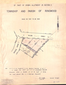
Document - Plan of Subdivision, Part of Crown Allotment 25 Section E, Township and Parish of Ringwood - 1961
Map showing residential allotments numbered 1, 2, 3 and 4, on Wilson Street and Braeside Avenue, Ringwood East, Victoria.Signed and dated 1/12/1961. Rubber stamped Kirkpatrick & Webber, Licensed Surveyors, Civil Engineers & Town Planners, 225 Maroondah Highway, Ringwood, Telephone 870-0321. Ref 3438C. "Note: Lot 4 is to be transferred to the Registered Proprietor of Lot 2 on Lodged Plan 23477 and is to be consolidated therewith." Map also includes handwritten Estate Agent notations. -
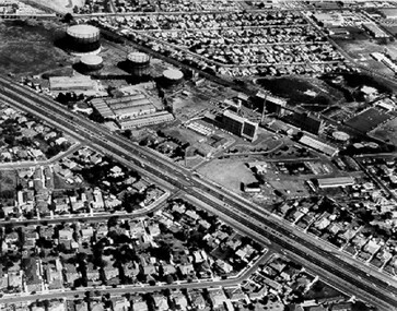 City of Kingston
Photograph - Black and white, c. 1970
The Highett Gas Works were a landmark along the Nepean Highway for many years. With the cessation of the gasification of coal and the introduction of natural gas to Victoria, the gas holders were demolished and the Sir William Fry Reserve was developed on the southern end of the site. The Gas and Fuel redeveloped the northern end of the site with modern offices and laboratories for the organisation's scientific services. At this time, the chimney and retort house were retained.The Highett Gasworks had its beginning in 1939 operated by the Central Brighton and Moorabbin Gas Co Ltd. The company had expanded its gas production facilities to Highett where it had purchased 45 acres of land adjacent to the Melbourne-Frankston railway line. The first gasholder was erected on the Highett site in 1927 and connected with high pressure mains to the Brighton Gas Works. In 1939 the building program including gasometers, the vertical retort house and coal store was completed and gas making commenced. Its area of supply covered approximately 70 square miles and included the municipalities of Brighton, Sandringham, Moorabbin, Mordialloc, Chelsea and part of Dandenong. The Gas and Fuel Corporation eventually took over operations and with the disaggregation and privatisation of the organisation, the site was eventually closed c. 2002.Black and white aerial photograph featuring the Highett Gas Works with gasholders and retort house. In the top right-hand corner, a former Highett Primary School on Graham Road can be viewed. Photograph includes Bay Road, Royal Avenue, Princess Avenue and Jackson Road (Highett) and Alfred, Turner and Sandford Streets (Moorabbin).Handwritten in black ink: [indecipherable] in a circle Handwritten in red ink: 70% Four velcro display adhesivesgasification of coal, gas and fuel corporation of victoria, gasholders, highett, moorabbin, utilities -
 Greensborough Historical Society
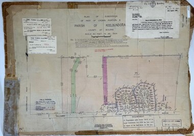
Poster - Planning Document, City of Heidelberg et al, Subdivision Plan # H 41 - Crown portion 8, Parish of Keelbundoora - Yallambie, and Crown Portion 9, Parish of Keelbundoora, 1922-1967
Planning Document: Subdivision Plan # H 41 Side 1, Crown portion 8, Parish of Keelbundoora - Yallambie Road, Allima Avenue, Koolya Court, Ekam Court (Jennings Estate). Side 2: Crown Portion 9, Parish of Keelbundoora consist of 5 small subdivision sheets: 1. Somers Avenue, Stewart Terrace, Toubay Street and Railway Place (no date); 2. Somers Avenue, Maxwell Street, Greensborough Road, 1924; 3. Heidelberg Avenue, Golf Avenue, St Andrews Avenue (no date); 4. Birdwood Avenue, May Street (no date); 5. Strathallan Road 1924.An example of hard copy subdivision plans from the Greensborough area. Mainly from the Shire of Diamond Valley era (1964-1994).Plan (2 sided) mounted on heavy card. Stamped and handwritten Council permissions, dates and other details.subdivision plans, city of heidelberg, yallambie, macleod, greensborough -
 Sunshine and District Historical Society Incorporated
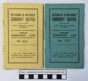
Membership Cards (1946), Sunshine & District Community Hospital, 30/09/1946
The hospital in King Edward Avenue Sunshine was originally known as St Andrew's Hospital and it was run by the Sisters Carruthers who in 1946 decided to retire. The hospital became the Sunshine & District Community Hospital on 15 September 1946. In the First Annual Report for the period 15 September 1946 to 30 June 1947, it is stated that of the 413 patients admitted 37.8% were members and 62.2% non members, and that the hospital was "...responsible for hospital attention under benefits to approximately 2000 residents." Just what the exact benefits were is unknown. Did members receive cheaper treatment, cheaper pharmaceuticals, guaranteed hospital bed, or something else? If anybody can provide the information it would be greatly appreciated. The 1946 cards show that L.W. Noble of Morris Street, Sunshine had a Single Membership which cost 26 shillings ($2.60) per annum, and that J.H.F Noble of the same address had a Double Membership which cost 39 shillings ($3.90) per annum. The cards were issued when payments for the first 4 weeks of membership were made, which were 2 shillings for Single and 3 shillings for Double. The stickers inside provide a record of continuing membership payments.These two cards indicate that membership of the Sunshine & District Community Hospital was a way of receiving Treatment or Membership benefits. This type of membership of a hospital appears to be a forerunner to the present day memberships provided by the various Hospital Benefits Associations. The cards also provide information about the cost of being a member of the Sunshine & District Community Hospital in 1946, and how the membership payments were recorded.The membership cards are actually small booklets with the Single Membership Card being Yellow coloured and the Double Membership Card being Blue coloured.Single Membership Card No. 983 / Double Membership Card No. 297 / Sunshine & District Community Hospital (Incorporated) / King Edward Avenue Sunshine / N.B.--This Card Must be submitted when requiring Treatment or Membership Benefitshospital membership card, sunshine & district community hospital, leslie noble, l.w. noble, j.h.f. noble, 94 morris street sunshine, king edward avenue sunshine, 30 september 1946, no. 983, no. 297, membership cards (1946) -
 Lakes Entrance Historical Society
Photograph - Barkes Avenue Lakes Entrance Victoria, M Holding, 2006
Colour photograph of R S L Anzac site in Barkes Avenue showing small brick building and cleared grounds enclosed by security fence site of earlier guesthouse Lakes Entrance Victoria. Also a colour photograph of Telstra building enclosed by security fence and shrubs Barkes Avenue 04283.1 size 10 x 15 cmbusinesses, township, roads and streets -
 Phillip Island and District Historical Society Inc.
Photograph, 1960
Donated by Jack JennerBlack & White photograph of shop buildings with Baker's shop on corner of Chapel Street & thompson Avenue. Pine trees and buildings beside and in the background.On back: "About 1960"phillip island bakery, cowes shop buildings, phillip island, jack jenner -
 Ringwood and District Historical Society
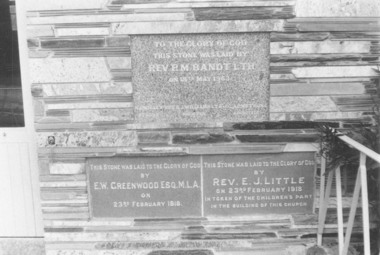
Photograph, Foundation plaques at the Methodist Church in Greenwood Avenue, Ringwood in 1973, 1973
Foundation plaques at the Methodist Church in Greenwood Avenue in 1973 +Additional Keywords: Rev RM Brandt / EW Greenwood / Rev EJ LittleWritten on back of photograph, "22/7/73 Meth. Church C/R Greenwood Av. 2 bot. (bottom) stones are from old church same site." Plaque laid by Rev RM Brandt on 18th May 1963, plaque laid by EW Greenwood MLA on 23rd February 1918 and third one laid by Rev EJ Little on 23rd February 1918. -
 Ringwood and District Historical Society
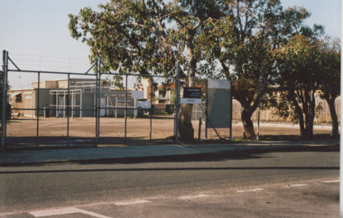
Photograph, Aerial view showing East Ringwood oval, Mount Dandenong Road, and Civic Centre, Braeside Avenue/Maroondah Hwy, c.1970
Aerial view showing East Ringwood oval, Mount Dandenong Road, and Civic Centre, Braeside Avenue/Maroondah Hwy, c.1970. -
 University of Melbourne, Burnley Campus Archives
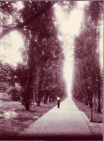
Photograph - Black and white or sepia print, Fitzroy Gardens, Unknown
Probably Fitzroy Gardens according to Georgina Whitehead who was writing a book on Public Gardens of Melbourne City Council, 1991.Black and white/sepia photograph of an avenue of Poplar trees in a Public Garden. A man standing in the middle of a wide path. Some iron fencing.avenue, poplar trees, fitzroy gardens, georgina whitehead, public gardens, melbourne city council -
 Whitehorse Historical Society Inc.
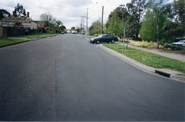
Photograph, Victoria Street, Mitcham, 1/10/2000 12:00:00 AM
Coloured photograph of of Victoria Street looking east. Car is exiting from multi storey car park in Edward Street into Victoria Avenue.victoria street, mitcham -
 Whitehorse Historical Society Inc.
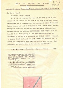
Document, Drainage of, 30/01/1937 12:00:00 AM
Notice from Shire of Blackburn and Mitcham to Doris Gorsuch, Vernal Avenue, Mitcham requiring access for forming a drain, 30 January 1937.Notice from Shire of Blackburn and Mitcham to Doris Gorsuch, Vernal Avenue, Mitcham requiring access for forming a drain, 30 January 1937.Notice from Shire of Blackburn and Mitcham to Doris Gorsuch, Vernal Avenue, Mitcham requiring access for forming a drain, 30 January 1937.shire of blackburn and mitcham, gorsuch, doris, drainage, vernal avenue, mitcham -
 Whitehorse Historical Society Inc.
Photograph, Turner Home in Salisbury Ave Blackburn, 1957
Collected at a Heritage Week Workshop at Blackburn Library on 5th October 2009.Black & white photograph Turner home at 27 Salisbury Ave Blackburn showing view looking from Middleborough Road to Salisbury Avenue.salisbury avenue blackburn no 27, 1950's house -
 Bendigo Historical Society Inc.
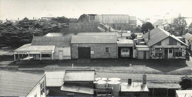
Administrative record - Aileen and John Ellison Collection: Correspondence
BHS CollectionA series of letters and meeting notes between the Shire of Marong and Mr. E.J. Ellison in regards of work to be done in Archer Street and Jacks Avenuelocal government, 1970, engineering -
 Kew Historical Society Inc
Slide - 'Tarring', Ruyton Girls' School, 1979
One of a group of slides taken by members of the Society of built heritage in Kew in 1979-80. The selection of subject matter reflects the priorities of the period. The colour of some slides has degraded.The slides represent a snapshot in time of built architecture in Kew, much of which has changed in the forty-plus period since they were created. 35mm colour transparency (slide) of 'Tarring' on the corner of Wellington Street and Selbourne Avenue; now part of Ruyton. The photo was developed in May 1979.ruyton girls' school, tarring, schools -- kew (vic.) -
 Kew Historical Society Inc
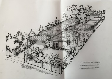
Drawing - Property Illustration, Margaret Picken, 7 Studley Avenue, Kew, 1996
After training as a Cartographic Draftsman within the mining industry, I worked as a property illustrator for real estate firms in the eastern suburbs of Melbourne for 22 years from 1983. I initially photographed houses with a Polaroid camera and made a 'thumbnail' sketch while there. The photos were used to scale off a sketch in pencil and then that sketch was overlaid with drafting film and the 'pen and ink' completed. The pens I used were the Rotring ‘Rapidigraph’ drafting pens. The ink was also made by Rotring (German).The film was ‘Rapidraw’, polyester drafting film, double matte. It takes a very fine line and doesn’t bleed. As well as house sketches, there were often floor plans and site plans ordered. Aerial sketches were ordered when the property needed an overall view. (Margaret Picken, 2020)This drawing is one of a series created by Margaret Picken for a number of real estate agents in Melbourne between 1983 and 2005. Each work is signed and dated by the artist.Gift of Margaret Picken, 2020Residence at 7 Studley Avenue, Kew, designed by the architect Ernest Fooks. The pen and ink property illustration was made by Margaret Picken in 1996.7 STUDLEY AVE., KEW / MARGARET PICKEN ~96 / WOODARDS ~ HAWTHORNartist -- margaret picken 1950-, 7 studley avenue - kew (vic), ernest fooks (architect), property illustrations -- kew (vic.) -
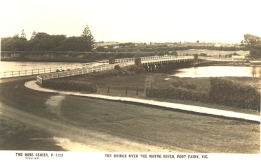
 Port Fairy Historical Society Museum and Archives
Postcard, The Rose Series / The Rose Stereographs, The Bridge over Moyne River, Port Fairy Vic
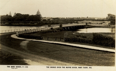
Black and white Photograph of the Moyne river road bridge with the botanical gardens in the left background and some huts built possibly on Hughes AvenueThe Rose Series P.1123 copyright.- The Bridge over the Moyne River Port Fairy Vic.moyne bridge, hughes avenue, gipps street, river, dunes, botanical gardens -
 Port Fairy Historical Society Museum and Archives
Postcard, The Rose Series / The Rose Stereographs, The Bridge over Moyne River, Port Fairy Vic
Black and white Photograph of the bridge over the Moyne river with the Botanical Gardens on the left in the background and also some huts on Hughes Avenue in the backgroundThe Rose Series P. 1123 copyright- The Bridge over the Moyne River Port Fairy Vic.moyne bridge circa 1930, moyne river, bridge, river, botanical gardens -
 Canterbury History Group
Pamphlet - Mont Albert Park, Camberwell
Copy of the pamphlet for subdivision of Mont Albert Park, includes Mangarra Road, Malaca Road, Gwinda Avenue, Irilbarra Road and Canterbury Roadcanterbury, canterbury road, gwenda avenue, irilbarra road, mangarra road, malaca road, mont albert park, land subdivision -
Canterbury History Group
Ephemera - Golden Mile Award winner, 1/03/2011 12:00:00 AM
Real estate advertisement from the Weekly Review for the auction on 19 March of 7a Alexandra Avenue, Canterbury.Incudes coloured photographs of the interior and exterior.canterbury, alexandra avenue, golden mile, townhouses, mannerheim> phillip, master> brian lee, hia townhouse of the year, stairs -
Canterbury History Group
Ephemera - Timeless elegance in the Golden Mile, 1/02/2011 12:00:00 AM
Real estate advertisement from the Weekly Review for the auction of 33 Alexandra Avenue Canterbury c1920. Includes coloured photographs of the interior and exteriorcanterbury, alexandra avenue, golden mile, swimming pools -
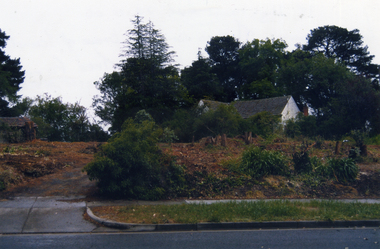 Whitehorse Historical Society Inc.
Photograph, Highland Avenue Mitcham, No.38
Three coloured photographs of the clearing of 38 Highland Avenue, Mitcham in 2006. This is the last piece of land that was originally part of Cherry Tree Farmcherry tree farm, mitcham, highland avenue, no.38, farming -
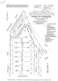 Ringwood and District Historical Society
Document - Subdivision Plan, LP12308 Crown Allotment 14C and Part of Crown Allotment 14A Parish of Ringwood, County of Mornington Vol 5378 Fol 511 - Circa 1927
LANDATA Land Victoria 4-sheet plan printout dated 2009.Sheet 1 includes Canterbury Road, Heathmont Road, Dickasons Road and Bennett Avenue, Heathmont. Additional markings include PC353066. Sheet 2 includes Heathmont Road, Bennett Avenue and Orchid Street, Heathmont. Additional markings include PS326369 and SP24567. Sheet 3 includes Dickasons Road and Bennett Avenue, Heathmont. Additional markings include LP46776, SP28005 and PS335189. Sheet 4 includes Dickasons Road, Bennett Avenue and Orchid Street, Heathmont. Additional markings include SP25998, SP31080, SP31780, SP25968, SP25969 and LP46475. -
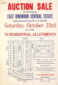 Ringwood and District Historical Society
Flyer, Land Auction Sale Advertisement, East Ringwood Central Estate - 1948
See Victorian Collections reference 5125 for subsequent Central Estate East Ringwood subdivision flyer.Single sided land auction sale advertisement for residential allotments.Auction Sale on the property under instructions from Mr. F.A. Salter. Subdivision includes Dublin Road, Knaith Road, Talofa Avenue, Russet Road, and Shasta Avenue. Agent - C.E. Carter & Son, Main Street, Ringwood. WU 6024. -
 Ringwood and District Historical Society
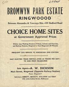
Flyer, Bromwyn Park Estate, Ringwood - 1946 - Avertising Brochures and Map
Two pages of subdivision features, services and locationSubdivision plan includes Alexandra Road, Marwarra Street, Tooronga Road, Hilary Grove, Morcom Avenue. -
 Ringwood and District Historical Society
Photographs, 1979-80 MMBW pipe line project at Hubbard Reserve, North Ringwood � First hole west of bore hole at 39 Burlock Avenue
Part of a 43-photo record of the MMBW�s engineering feat in drilling a 12 inch pipe line up to 40 feet deep through rock hardened by volcanic action associated with geological fault that occurs along the line. The work took place from October 1979 to May 1980 on the southern boundary of Hubbard Reserve, North Ringwood. The collection was presented to the Ringwood Historical Research Group by J Clarke on 9th June 1980.E561 N9 Feb 1980 A43 First hole west of bore hole at 39 Burlock Avenue -
 Whitehorse Historical Society Inc.
Painting - Framed oil painting, 1953
Looking East near Springvale Road Daniel Robertson ClayworksOil painting of Nunawading Railway station and clayworks.Railway Nunawading by J. B. Bryce 1953 and J. Bingley 22 Victoria Avenue, Canterbury 2816.daniel robertson, nunawading station -
 Ringwood RSL Sub-Branch
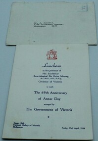
Document, Invitation to Luncheon, Friday 13th April 1984
Envelope and printed signed menuMr J Russell, 5/29 Salisbury Avenue, Laburnum. 3130. 69th Anniversary of Anzac day. -
 Kew Historical Society Inc
Photograph - Electric tram line construction in Cotham Road, Kew, E.J. Dower, 1913
One of a series of photographs, taken by Edgar James Dower in the second decade of the twentieth century. Born and raised in Olinda, his family later moved to Surrey Hills. He worked as an adult as a clerk in the city office of the Metropolitan Gas Company, and in his role as a 'collector', he was able to photograph scenes including the construction of tramlines and associated buildings in Kew, Hawthorn, Camberwell and Surrey Hills. Later he established a real estate agency with his brother - the E.J. Dower Real Estate Agency, Dandenong Office.The image is an historically significant record of the development of transport infrastructure which was used to connect Victorians in the first two decades of the twentieth century. This development resulted from increases in population and the consequent extension of Melbourne's suburbs. The photographs, both individually and collectively, richly detail the labour of workers and the tools and machinery used to create and extend Melbourne's tram network in the years preceding and during World War 1.Digital copy of an original mounted photograph depicting construction of a new electric tramline in Cotham Road, Kew. The photo shows workers with an early steamroller.Annotated verso: "Preparing for electric trams / Cotham Road Kew / Taken near Barrington Avenue / 1913"theme --- travelling by tram, theme -- connecting victorians by transport and communications, cotham road -- kew (vic.), trams -- kew (vic.) -
 Phillip Island and District Historical Society Inc.
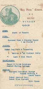
Document, Bayview Dinner Menu, 23/09/1932
Bay View Guesthouse was located on The Esplanade between Thompson Avenue and Warley Avenue, Cowes, Phillip Island Typed menu for dinner on 23/9/1932 at "Bay View", guesthouse, Cowes. Small round photo of a koala on the Menu.Above the koala - Welcome to "Bay View". Below: "I hope you'll enjoy your stay." Followed by the menu of Soup: Fish: Joints: Vegetables: Sweets:bay view guest house, bay view cowes phillip island, guesthouses cowes phillip island, j west, dinner menu -
 Bendigo Historical Society Inc.
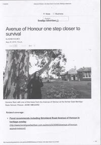
Photograph - 2015 Bendigo East State School Newspaper Article
The sheet of photocopied A4 size paper is of a newspaper article from the Bendigo Advertiser dated August 24, 2015, titled 'Avenue of Honour one step closer to survival by Adam Holmes. The photograph shows Gemma Starr with one of the trees from the Avenue of Honour at the former East Bendigo State School. photographer is Jodie Wiegard. Gemma Starr Collectionbendigo east state school, bendigo schools, gemma starr collection, school avenue of honour, gemma starr, adam holmes, jodie wiegard