Showing 15145 items matching "view"
-
 Mission to Seafarers Victoria
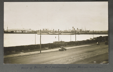
Photograph - Photograph, Sepia, View of Piers, Port Melbourne from Mission windows, Early 20th C
This image appears to have been taken from the second storey of the Mission to Seamen, on Beach Rd Esplanade, Port Melbourne circa 1912 - 1920. One of several images on loose album pages.An early image taken from the building established in Port Melbourne initially in the mid 19th C and operating up to the 1930s until replaced by a modern deco building in 1936. Shows examples of vintage cars.Small Landscape B and W image of ships moored alongside a pier in distance and small early car in foreground on unsealed road travelling left to right. Handwritten descriptive inscription is written underneath on an album page.port melbourne, mission to seamen building, port melbourne pier, fan album -
 Mission to Seafarers Victoria
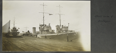
Photograph - Photograph, Sepia, Close View of the Destroyer, 5-9 November 1928
The HMAS Australia arrived in Port Melbourne on Monday 5 November 1928 and let Friday 9 November for Adelaide and was open to the public from the 5th.fan album, destroyers, port melbourne, station pier -
 Lorne Historical Society
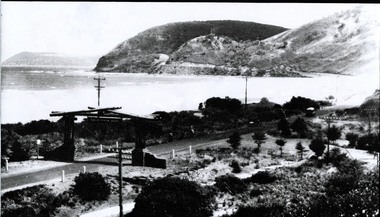
Photograph, Eastern View - The Memorial Archway, 1939
-
 Lorne Historical Society
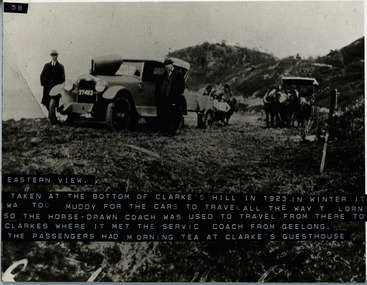
Photograph, Great Ocean Road, Eastern View at bottom of Clarke's hill 1923
Photoof a car with passengers. In winter it was too muddy for passengers in cars to travel all the way to Lorne so a horse drawn coach was used to travel to Clarke's where it met the service coach from Geelong. The passengers had tea at Clarkes Guest HousePhotograph of car, passengers and horse drawn coach. Inscribed "taken from the bottom of Clarke's Hill in 1923" In winter it was too muddy for cars to travel all the way to Lorne so the horse drawn coach was used to travel from there to Clarke's Hill where it met the service coach from Geelong. The passengers had tea at Clarke's Guesthousegreat ocean road, m1923 clarkes guest house, coach. winter transport -
 Lorne Historical Society
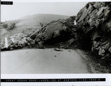
Photograph, Landslide at Devil's Elbow, Eastern View
Photography of landslide at Devil's Elbow on the Great Ocean Road circa 1940'sg.o.r; devil's-elbow-landslide; landslide-1940's; -
 Koroit & District Historical Society
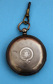
Pocket Watch, Front view
pocket, watch -
 Mission to Seafarers Victoria
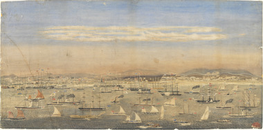
Print - Reproduction, Wilbraham Frederick Evelyn Liardet, View of the North Shore, Port of Melbourne, 1862
Liardet, W. F. E. (Wilbraham Frederick Evelyn), 1799-1878 depicts the busy port of Melbourne showing many types of ships and the Bethel Church built in 1860 on the Custom House land. The church replaced the Bethel ship which sank in February 1860.This watercolour along with the Francois Cogne print from 1863, "Sandridge from Hobson's Bay, and the engraving "A Bird's-eye View Of Melbourne From Sandridge" dating from 1882, is a rare depiction fo the Bethel church. In 1887, the church was demolished to erect the building still standing on the corner of Nott Street and Beach Road.wilbraham liardet, sandridge, port, ships, port melbourne, hobsons bay, bethel church, reverend kerr johnston, 1812-1887, missions to seamen, 1862, customs house -
 Greensborough Historical Society
Photograph - Digital Image, View of Valley Buildings, Greensborough 1970s, 1970s
Photograph of the Valley Buildings, Main Street Greensborough, as seen from the rail line. Shows Connie Burkett's hair salon.Digital copy of black and white photograph. Cropped from item6660.trains, main street greensborough, connie burkett -
 Greensborough Historical Society
Article, Journal, Jane Rizzetti, Banyule Homestead Subdivision: a personal view, by Janine Rizzetti, 2014_10
Account of community concerns about development of the Banyule Homestead, and a photograph of the Homestead.2p. photocopy of article in History News, Issue 374, Oct/Nov 2014banyule homestead -
 Glenelg Shire Council Cultural Collection
Textile - Tapestry, Portlands Fibre Group, Women's View On Peace, 1987
International Year of Peace TapestryTapestry depicting three outlines of doves, with depictions within their outlined shape of stars, flowers, and two sets of (depicted in white and brown) holding wheat and corn. The background is composed of rainbow colours arranged in horizontal strips, with red at the top and indigo at the base.textile, international year of peace, tapestry, wool, weave -
 Glenelg Shire Council Cultural Collection
Sculpture - Bas-relief, Untitled (Modern Portland Port View), n.d
Commissioned by State Bank to produce 5 copper bas-reliefs for 73 Percy Street, Portland. Spoke with Miss Betty Vivian (Member of the Portland Historical Society) re Portland's history. Commonwealth Bank stored objects in Melbourne (c.1991). Negotiations between Portland Historical Society and Commonwealth Bank of Australia led to gift of works to People of Portland. Stored at Council depot c.1998, retrieved for Maritime Discovery Centre display.Copper bas-relief. Depicting of port with 14 large silos and a large domed shed in background. On horizon line is a wharf with a ship berthed. In foreground left is a pier stump with wood nailed to it, and leaning on it is a large anchor with a rope tied to it. In foreground left is a beach area, diminishing rapidly toward port in background.Front: (no inscriptions) Back: (unknown)sculpture, bas-relief, copper, port of portland, portland harbour -
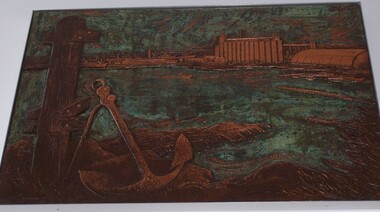
 Greensborough Historical Society
Photograph - Digital image, View from Greensborough Lower Oval, 1935c
Photograph of the Greensborough Lower Oval in Main Street Greensborough opposite St Helena Road. The village of Greensborough can be seen In the background.An early view of Greensborough.Digital copy of black and white photograph.greensborough, lower oval greensborough -
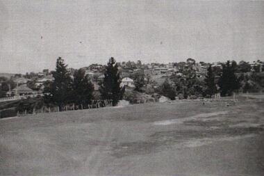
 Greensborough Historical Society
Photograph - Digital image, View from Greensborough station, 1920c
Photograph of men with horse-drawn coach in the vicinity of Greensborough station, early 20th century.Digital copy of black and white photograph.greensborough station -
![Photograph - Digital image, Loyola Seminary 1 [aerial view] 1934, 1934_](/media/collectors/4f729f5697f83e03086015b8/items/54b9e7f82162f10918709419/item-media/54b9e8272162f109187096d4/item-fit-380x285.jpg) Greensborough Historical Society
Greensborough Historical SocietyPhotograph - Digital image, Loyola Seminary 1 [aerial view] 1934, 1934_
Part of a collection of photographs of the Jesuit Seminary in Grimshaw Street Watsonia. Opened in 1934, this was a house of formation and study for the Society of Jesus. Loyola College (established 1980), now occupies the site and purchased the original building in 2002.Digital copy of black and white photograph.loyola seminary watsonia, loyola college -
![Photograph - Digital image, Loyola Seminary 7 [Aerial view with Surrounding Area] 1934, 1934_](/media/collectors/4f729f5697f83e03086015b8/items/54b9eba92162f1091870c075/item-media/54b9ebf22162f1091870c374/item-fit-380x285.jpg) Greensborough Historical Society
Greensborough Historical SocietyPhotograph - Digital image, Loyola Seminary 7 [Aerial view with Surrounding Area] 1934, 1934_
Part of a collection of photographs of the Jesuit Seminary in Grimshaw Street Watsonia. Opened in 1934, this was a house of formation and study for the Society of Jesus. Loyola College (established 1980), now occupies the site and purchased the original building in 2002.Digital copy of black and white photograph.loyola seminary watsonia, loyola college -
![Photograph - Digital image, John McLaughlin's home in Fairy Hill South Morang [distant view], 1910c](/media/collectors/4f729f5697f83e03086015b8/items/54bccb6e2162f10b905d311a/item-media/54bccb9e2162f10b905d3410/item-fit-380x285.jpg) Greensborough Historical Society
Greensborough Historical SocietyPhotograph - Digital image, John McLaughlin's home in Fairy Hill South Morang [distant view], 1910c
Part of a collection of photographs copied from the late Shirley Fraser (nee Black), also descendant of the McLaughlin and Whatmough family. This photograph shows John McLaughlin's home Fairy Hill in South Morang.Digital copy of black and white photograph.shirley fraser, john mclaughlin, fairy hill -
 Greensborough Historical Society
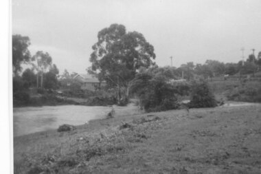
Photograph - Digital Image, Plenty River in flood 1972, view at the Rand Street Crossing, 1972_
Plenty River in flood at the Rand Street Crossing. There were two major floods in Greensborough at the time, 1972 and 1974. Poulter Reserve was created after the 1972 flood and had to be re-established following the 1974 flood.Digital copy of black and white photograph.plenty river, floods -
 Greensborough Historical Society
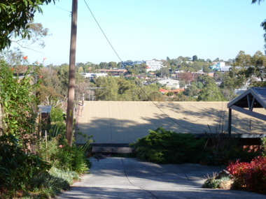
Photograph - Digital image, View of Greensborough from Delfin Crescent, 02/05/2013
This photograph of Greensborough was taken from Delfin Crescent in 2013 to show changes over 40 years, based on Ron Reynold’s sketches in the 1973 publication “Greensborough and Greenhills” published by Cypress Books. Delphin Crescent [previously known as Medhurst Street] was created about 1970 in association with the Delfin Building Company. It was at this time also, that major works on Diamond Creek Road raised the level of the road facilitating the connection of Delfin Crescent with Diamond Creek Road. [Note: 'Medhurst Street was only listed on planning maps pre 1950 when the 'street' had no residents or development.]Digital copy of colour photograph.greensborough and greenhills -
![Photograph - Digital image, Willis Vale [side view], 1950c](/media/collectors/4f729f5697f83e03086015b8/items/5502a2592162f11024c32328/item-media/5502a2852162f11024c3268d/item-fit-380x285.jpg) Greensborough Historical Society
Greensborough Historical SocietyPhotograph - Digital image, Willis Vale [side view], 1950c
Willis Vale: House built by Edward Maygar, Robert Whatmough lived there mid 19th century and later sold to Partington family. It was located on the Plenty River at Partington's Flat Greensborough. Land use included farming and orchards. The derelict Willis Vale house was vandalized in 1964 and destroyed when a fire originating from North Plenty Gorge - Kurrak Road - was lit by two teenage boys and made its way several kilometres down to Partington's Flat Greensborough. This photo was taken after the Partington's moved house in 1947. across the river where Alan built their new Alwyn house that had access to electricity. Home of the Partington family Home of the Partington familyDigital copy of black and white photograph.willis vale, partington, whatmough, maygar -
![Photograph - Digital Image, 16 Poulter Avenue [exterior, side view], 21/05/2014](/media/collectors/4f729f5697f83e03086015b8/items/550906f72162f1199c25606f/item-media/550907382162f1199c256504/item-fit-380x285.jpg) Greensborough Historical Society
Greensborough Historical SocietyPhotograph - Digital Image, 16 Poulter Avenue [exterior, side view], 21/05/2014
Built in the 1930s, this property has been restored.Digital copy of colour photograph.poulter avenue -
 Greensborough Historical Society
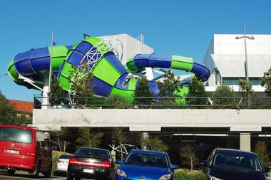
Photograph - Digital image, Marilyn Smith, Watermarc: View of slide from carpark, 19/08/2015
Taken in 2015 this photograph shows the outside of the waterslide at Watermarc.Digital copy of colour photograph.watermarc -
 Greensborough Historical Society
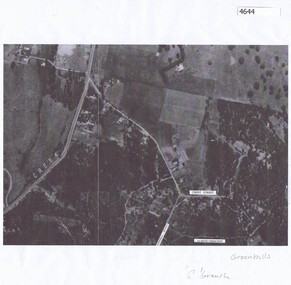
Aerial Photograph, Flintoff land - View from above, 1945_
Section of the 1945 Greensborough aerial survey, focusing on the land belonging to the Flintoff familyPhotocopy of section of 1945 aerial survey of Greensborough area"Flintoff land to west of Diamond Creek Rd" written in pencil on backflintoff family, aerial photograph -
 Greensborough Historical Society
Aerial Photograph, Greenhills Aerial View, 1945_
Section from the 1945 aerial survey of Greensborough, including part of Diamond Creek Road, Greenhill Road, Crest Street and Albion Crescent.Photocopy of part of 1945 aerial survey. Some streets have been marked.greenhills -
 Greensborough Historical Society
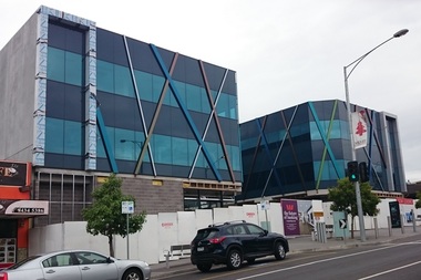
Photograph - Digital image, Marilyn Smith, 78 Main Street Construction - Front View, 18/01/2016
Development on Main Street Greensborough (front), January 2016. Shows the changing streetscape of Main Street.Digital copy of colour photographmain street greensborough -
 Greensborough Historical Society
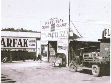
Photograph - Digital Image, Stubley Garage - external view, 1946_
Stubley Garage 1946. The Stubley Group began in 1946 when Purcell Stubley purchased a site with petrol bowsers in Main Street from 'Snowy' Jessop. In 1948 Purcell began building the new Stubley Motors, working round the old site to keep the business operating. It was completed in 1951.Digital copy of black and white photographpurcell stubley, stubley motors, stubley group greensborough -
 Greensborough Historical Society
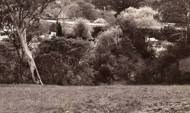
Photograph - Digital image, Jan Lewis, View From Flintoff Street Swing Bridge to the Sondemeyer's House in Briar Hill circa 1958, 1958c
From Flintoff Street swing bridge to Sondemeyer's circa 1958 Digital copy of black and white photographflintoff street, sondemeyers hill -
 Greensborough Historical Society
Photograph - Digital image, Jan Lewis, View from Sondemeyer's House overlooking the Greensborough Tea Gardens and bridge circa 1958, 1958c
From Sondemeyer's overlooking Tea Gardens and bridge circa 1958Digital copy of black and white photographsondemeyers hill -
 Greensborough Historical Society
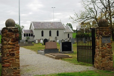
Photograph - Digital image, Marilyn Smith, St Katherine's Church St Helena: View of Church through entrance gates, 29/05/2015
St Katherine's Church St Helena dates from 1858. The Church was built by Major Anthony Beale in memory of his wife Katherine Rose Beale. This photograph shows the Church through the entrance gates.Digital copy of colour photographst katherines church st helena, anthony beale -
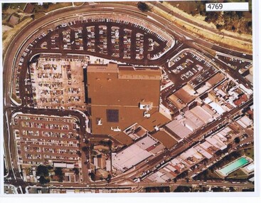 Greensborough Historical Society
Aerial Photograph, Greensborough Plaza Aerial View, 1979c
Early aerial photograph of Greensborough Plaza, 1970.Colour photocopy of aerial survey, laminatedgreensborough plaza -
 Glenelg Shire Council Cultural Collection
Photograph, View across North Portland to Bridgewater Bay, 1968
Port of Portland Authority archives.Front: (no inscriptions) Back: LOOKING ACROSS NORTH PORTLAND TOWARDS BRIDGEWATER BAY JULY. 1968port of portland, bridgewater bay, wool stores