Showing 9343 items matching "warrandyte"
-
 Ringwood and District Historical Society
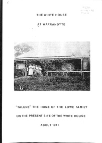
Book, The White House At Warrandyte, 1988
The first known residents were Mr and Mrs Walter Pretty and their family who moved there in 1856. Mr William Collins took out a miner's right in 1886 and Mr and Mrs Frank Lowe bought the freehold when the site was auctioned in 1930.History of families associated with the property originally leased on a miner's right near the corner of Yarra Street and Cemetery Road circa 1850s, and later had a frontage to the Main Road with access from to Taroona Avenue. -
 Ringwood and District Historical Society
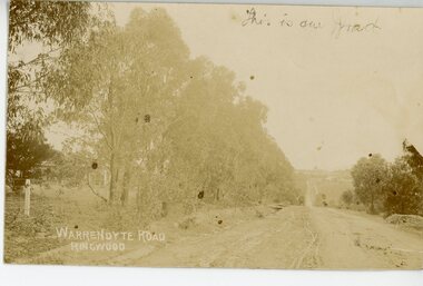
Photograph/Postcard, Warrandyte Road, Ringwood Circa 1900's
Sepia photograph/post card"Written on back of Post Card" Writings from a Cousin -
 Eltham District Historical Society Inc
Photograph, Fay Bridge, Former Glynn's Dairy Farm, Glynns Road, North Warrandyte, 31 August 2018
Glynn’s farm Originally Section 7, Parish of Nillumbik marked Aborigine Reserve in 1866 Crown Allotment 8, Section 7, Parish of Nillumbik, County of Evelyn, Certificate of Title Volume 4095, Folio 818.835, approx. 93 acres purchased by Joseph Panton in 1881 for £1/acre and known as Panton’s Point. By 1924 owned by S.S. Sergeant and called Riverswood. Sergeant commissioned Edna Walling to design the garden. In September 1929 the property was sold at auction by Mortgagee’s sale. Described as well built, brick, tile roof, Attic Villa containing downstairs 7 good rooms, bath, scullery, inside lavatory, etc. Upstairs 2 bedrooms and sleep out. Outbuildings compromising of brick and weatherboard wash house, stables, workshop, feed room, cow bails, large G.I. Hay shed, etc In January 1931 Riverswood property was proclaimed a sanctuary for native game for the entire year. A private swing bridge crossed the river at Pound Bend was known as Pearson’s bridge after C.W.K. Pearson who bought Riverswood in the early 1930s. The bridge was swept away in the December 1934 floods. Riverswood was sold by C.W.K. Pearson at auction on 25 November 1936. Described as a beautiful farm home of 93 acres and over one mile of River Yarra frontage, modern brick residence, lovely garden, rich river flat pastures, model poultry farm. The fine brick home was destroyed on Black Friday (13 Jan.) 1939. It was still a ruin when the Evelyn Evans purchased Waikowhane above Riverswood in 1940. The Glynn family purchased the Riverswood property in 1941 from Robert and Emily Hannon. Their son Kenneth Patrick Glynn inherited the property and he set about clearing the land during WW2 selling wood. Prior to marriage, Kenneth was living alone on the farm in a house he had built from whatever was available. He used the bluestone foundations from the original fine brick home. He met and married Honora Elizabeth Drew in early 1945 and their daughter Anna grew up on the farm. It was compulsorily acquired by the Board of Works in 1976 who then rented the house out in the 1980s. The property was transferred to Melbourne Parks and Waterways in 1996. Waikowhane was a pretty timber house built on top of the hill on 50 acres above Riverswood by retired nurse Jessie MacBeth. (This would be at the intersection of Glynns Road and Overbank Road where the big water tank is now situated on what was once James Orford’s property.) It was also destroyed Black Friday and she rebuilt it from the plans living in a caravan on site supervising the build. It was almost complete when she died May 1939. The property was bought by Evelyn Evans (a city girl) and her estranged husband in 1940. She had two sons, one only 9 months old at the time. It was a timber house with no power or water connected. The Ewen Cameron family bought Waikowhane in 1957. They had to evacuate when the 1961 bushfires swept through. The house was saved by Matcham Skipper. It was demolished by Melbourne Water in the 1990s when they acquired it.fay bridge collection, 2018-08-31, glynn's, glynn's dairy farm, glynns road, north warrandyte, parks victoria, ruins, riverswood, kenneth patrick glynn -
 Eltham District Historical Society Inc
Album - Photograph, J.A. McDonald, Research-Warrandyte Road, Sep. 1958
Between Blooms Road and Sloans Hill Primed – April 1956Record of various Shire of Eltham infrastructure works undertaken during the period of 1952-1962 involving bridge and road reconstruction projects, sometimes with Eltham Shire Council Project Reference numbers quoted. It was during this period that a number of significant improvements were made to roads and new bridges constructed within the shire that remain in place as of present day (2022). In many situations, the photos provide a tangible visible record of infrastructure that existed throughout the early days of the Shire. The album was put together by or under the direction of the Shire Engineer, J.A. McDonald.infrastructure, shire of eltham, bridge construction, road construction, 1956-04, research-warrandyte road -
 Eltham District Historical Society Inc
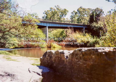
Photograph - Colour Print, Warrandyte Bridge over Yarra River, c.1987
Boundary for the Shire of Eltham and now Shire of Nillumbikwarrandyte bridge, yarra river -
 Eltham District Historical Society Inc
Book, D. Pendavingh, Yarra River Trail Plan 1989: Banksia Street to Warrandyte, 1989
Also contains a loose A3 mylar plan inserted - Depart of Planning and Urban Growth, Heidelberg; Main Yarra Trail; Warringal Parklands and Banyule Flats, Detail Plan and Locality Plan -
 Eltham District Historical Society Inc
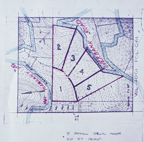
Slide - Photograph, Eltham Shire Council, Proposed subdivision of five approximately equal areas of 5 acres, Vol. 4061, Fol. 061, Overbank Road, North Warrandyte, 1969
35mm colour positive transparency blue Agfacolour Service plastic mountD4, 55341, Peck subdivision, Mount Pleasant Road, 4 August 1969infrastructure, map, planning, subdivison lots, overbank road, mount pleasant road, north warrandyte -
 Eltham District Historical Society Inc
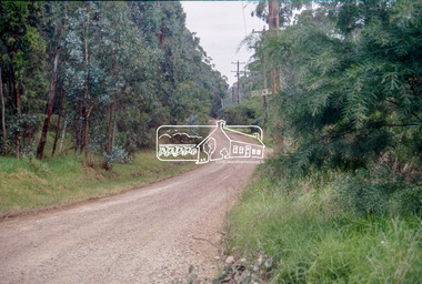
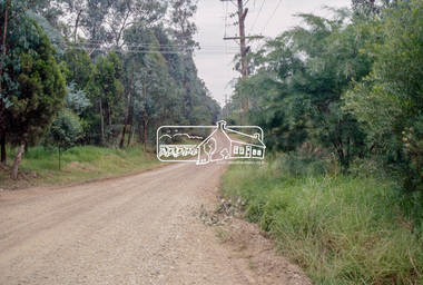
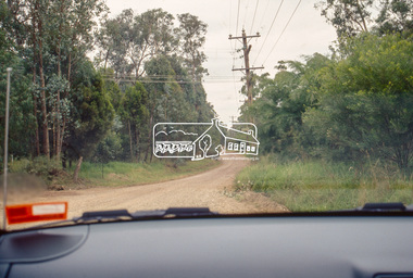
Photograph (Item) - Negative, Jocelyn Zepter-Trevor, Main Road at Research-Warrandyte Road, Research, 1988
Jocelyn Zepter-Trevor 1988 Entrant No. 69 Ref: Series 34, Item 24 The images in this record were not selected for inclusion. SHIRE OF ELTHAM COMMUNITY PHOTOGRAPHIC SURVEY Photography is an artform which many of us practice, sometimes purely for artistic pursuit, sometimes to record the people and events in our lives. In 1988, as part of a local Bicentennial project, the Shire of Eltham conducted the Eltham Community Photographic Survey. Up to 100 entries were to be selected by a panel of photographers for entry into the Eltham Photographic Survey Exhibition. Entries had to be submitted by May 13, 1988. Entrants whose images were selected for the exhibition were contacted and requested to further submit an entry form providing entrant’s name, area of residence, age, and proposed captions. These details were then used to produce labels for the exhibition mounts. Where negatives had not been supplied, these were requested to support the display of printed enlargements mounted on 10” x 8” cardboard. The mounted prints were made available post exhibition for sale at $8.50 each for colour prints and $7.00 for B&W prints. Residents in the Shire were invited to collect a free roll of film and take a photograph of what they either liked or did not like about the area. A total of 160 entrants submitted multiple entries for the exhibition. Of those selected for exhibition, entrants ranged in age from 9 to 70 years. All custom colour and black and white printing for the exhibition was completed by Wattle Studios of Eltham. The Eltham Photographic Survey was jointly auspiced by the Shire of Eltham and Wattle Studios, of 953 Main Road, Eltham. The project was greatly assisted by: • David McRitchie, Media Studies Lecturer Victoria College, Rusden Campus. • Ian and Annette Toohill of Wattle Studios • Tracy Naughton, Eltham Community Arts Officer • Neville Emerson Pty. Ltd. • Superior Press, Eltham • Kodak Australasia Pty. Ltd. • Agfa Gevaert Ltd. • Townsend Colourtech Pty. Ltd. • The Australian Bicentennial Authority • Eleanor Bowers, Secretary, Eltham Arts Council The exhibition was placed on display in the Woolworths Arcade, Eltham between Monday June 6th and Saturday June 11, 1988. It was also intended to hold the exhibition at a venue in the Shire’s North Riding from Monday, June 20 to Friday June 24. It was then displayed at the Were Street Theatre, Montmorency from Friday, June 24 to Thursday, July 7. Series 34: Eltham Community Photographic Survey 1988 - Prints & Documentation Series consists of 117 photographs of Shire scenes taken by members of the community. Items I - 41 are larger photographs mounted on card, which were exhibited. Items 42 - 117 are unmounted copies, alternative takes and other entries. Corresponding negatives contained in Series 35: Eltham Community Photographic Survey 1988 – Negatives which consists of 267 colour and B&W negatives and one colour slide of Shire scenes taken by members of the community. The negatives are arranged by the entrant number of the photographer. The Eltham Community Photographic Survey collection is significant to the local community as it was curated by the local community - ordinary people of all ages - representing what they liked and did not like in the area where they lived. It represents an unfiltered representation of the Shire of Eltham as it was in 1988. It also represents one of many projects as part of the national programme of events and celebrations to commemorate the bicentenary. It is a time capsule of life in the 1980s of this urban and rural municipality in Melbourne's north. shire of eltham archives, bicentennial project, eltham community photographic survey, film - agfa xr 100 i, jocelyn zepter-trevor, scan - 35mm negative, series 35, main road, research (vic.), research-warrandyte road -
 Eltham District Historical Society Inc
Photograph, Fay Bridge, Freesias near junction of Glynn's Road and Overbank Road, Norh Warrandyte, n.d
fay bridge collection, freesias, glynns road, laughing waters, overbank roiad -
 Eltham District Historical Society Inc
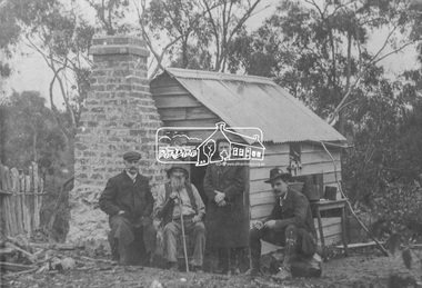
Photograph, Tom Allen in 'Uncle Tom's Cabin'. Wallaby Park, Warrandyte Road
Tom is the old man seated Source: Mrs. E.M. Jackson, Pigeon Bank, Kangaroo Ground.This photo forms part of a collection of photographs gathered by the Shire of Eltham for their centenary project book,"Pioneers and Painters: 100 years of the Shire of Eltham" by Alan Marshall (1971). The collection of over 500 images is held in partnership between Eltham District Historical Society and Yarra Plenty Regional Library (Eltham Library) and is now formally known as the 'The Shire of Eltham Pioneers Photograph Collection.' It is significant in being the first community sourced collection representing the places and people of the Shire's first one hundred years.Digital imagekangaroo ground, sepp, shire of eltham pioneers photograph collection, tom allen, wallaby park, warrandyte road -
 Eltham District Historical Society Inc
Slide - Photograph, Stony Creek Road, North Warrandyte, c.1993
35mm colour positive transparency Mount - Black and Whiteinfrastructure, roads, doleen road, north warrandyte, stony creek road -
 Eltham District Historical Society Inc
Slide - Photograph, Stony Creek Road, North Warrandyte, c.1993
35mm colour positive transparency Mount - Black and Whiteinfrastructure, roads, doleen road, north warrandyte, stony creek road -
 Eltham District Historical Society Inc
Slide - Photograph, Stony Creek Road, North Warrandyte, c.1993
35mm colour positive transparency Mount - Black and Whiteinfrastructure, roads, doleen road, north warrandyte, stony creek road -
 Eltham District Historical Society Inc
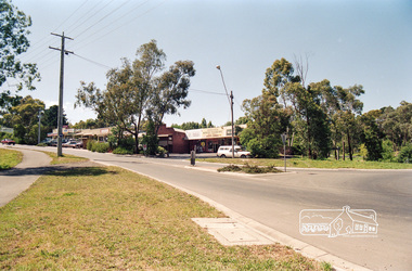
Photograph, Research Shops looking southeast from intersection of Main Road and Research Warrandyte Road, c.1992, 1992c
Roll of 35mm colour negative film, 7 strips Fuji 100main road, research (vic.), research warrandyte road -
 Eltham District Historical Society Inc
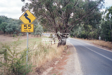
Photograph, Looking south along Kangaroo Ground-Warrandyte Road just east of Heidelberg-Kinglake Road, Kangaroo Ground, c.1989, 1989
Roll of 35mm colour negative film, 5 strips Kodak GA100 5095infrastructure, kangaroo ground, kangaroo ground-warrandyte road, streets -
 Eltham District Historical Society Inc
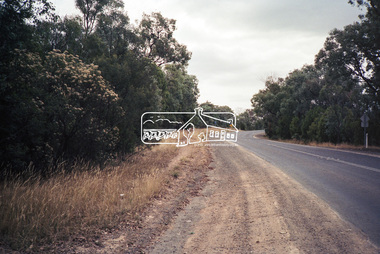
Photograph, Looking northwest along Kangaroo Ground-Warrandyte Road, Kangaroo Ground, c.1989, 1989
Roll of 35mm colour negative film, 5 strips Kodak GA100 5095infrastructure, kangaroo ground, kangaroo ground-warrandyte road, streets -
 Eltham District Historical Society Inc
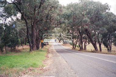
Photograph, Looking northwest along Kangaroo Ground-Warrandyte Road, Kangaroo Ground, c.1989, 1989
Roll of 35mm colour negative film, 5 strips Kodak GA100 5095infrastructure, kangaroo ground, kangaroo ground-warrandyte road, streets -
 Eltham District Historical Society Inc
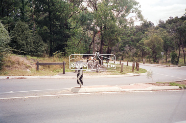
Photograph, Looking west along Main Road at intersection with Research-Warrandyte Road, Research, c.1989, 1989
Roll of 35mm colour negative film, 5 strips Kodak GA100 5095infrastructure, main road, research (vic.), research-warrandyte road, streets -
 Eltham District Historical Society Inc
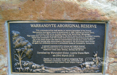
Photograph, Commemorative plaque on rock, Warrandyte Aboriginal Reserve, unveiled 23 March 2013
Colour photograph2013, plaques, warrandyte aboriginal reserve -
 Eltham District Historical Society Inc
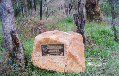
Photograph, Commemorative plaque on rock, Warrandyte Aboriginal Reserve, unveiled 23 March 2013
Colour photograph2013, plaques, warrandyte aboriginal reserve -
 Eltham District Historical Society Inc
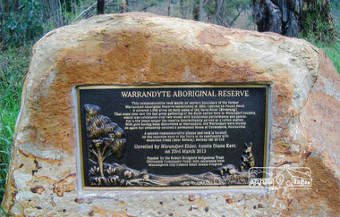
Photograph, Commemorative plaque on rock, Warrandyte Aboriginal Reserve, unveiled 23 March 2013
Colour photograph2013, plaques, warrandyte aboriginal reserve -
 Eltham District Historical Society Inc
Photograph, Believed to be an Alistair Knox designed mudbrick home, 145 Kangaroo Ground-Warrandyte Road; 2002, 2002
Eight colour photographshouses, mudbrick -
 Ringwood and District Historical Society
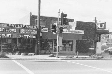
Photograph, North Ringwood Shopping Centre pedestrian crossing, Warrandyte Road, North Ringwood, near Dickson Crescent - July, 1981
Black and white photograph of shops. Pedestrian lights and crossing outside shops. -
 Ringwood and District Historical Society
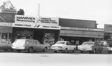
Photograph, North Ringwood Shopping Centre, Warrandyte Road, North Ringwood - July 1981
Written on back of photograph, "The Family Chemist, North Ringwood Shopping Centre". -
 Ringwood and District Historical Society
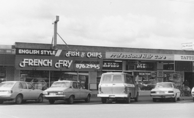
Photograph, North Ringwood Shopping Centre, Warrandyte Road, North Ringwood - July 1981
Written on back of photograph, "1-7-81. Norman's Hardware, North Ringwood Shopping Centre". -
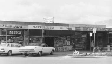
 Ringwood and District Historical Society
Photograph, North Ringwood Shopping Centre, Warrandyte Road, North Ringwood - July 1981
Written on back of photograph, "1-7-81. North Ringwood Shopping Centre". -
 Ringwood and District Historical Society
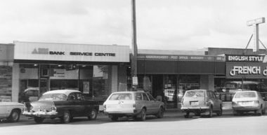
Photograph, North Ringwood Shopping Centre, Warrandyte Road, North Ringwood, including North Ringwood Post Office Agency - July 1981
Written on back of photograph, "1-7-81. The Post Office, North Ringwood Shopping Centre". -
 Ringwood and District Historical Society
Photograph, North Ringwood Shopping Centre, Warrandyte Road, North Ringwood, including Green's Newsagency - July 1981
Written on back of photograph,"1-7-81. Greens Newsagency, North Ringwood Shopping Centre". -
 Ringwood and District Historical Society
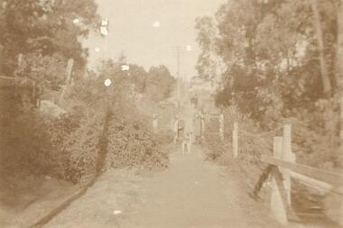
Photograph, Ringwood foot bridge, west side of Warrandyte Rd. 1919
Written on back of card, "Ringwood foot bridge, 1919". -
 Ringwood and District Historical Society
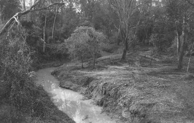
Photograph, Mullum Creek looking east from bridge in Warrandyte Road Ringwood. St. Paul's extreme left, 1972
Typed below photograph, "Mullum Creek looking east. St. Paul's extreme left, 1972".