Showing 123697 items matching "main-road"
-
 Ringwood and District Historical Society
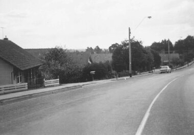
Photograph, South side of Bedford Road, Ringwood East, taken from outside shops on the corner of Illoura Avenue - 1/9/1974
Written on back of photograph, "Bedford Rd. looking at south side towards east from outside shops cnr. Illoura Ave. (As in brochure)" -
 Ringwood and District Historical Society
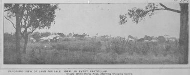
Photograph, Image used for land sale promotion of Pratt's Junction Estate opposite Mount Dandenong Road, Ringwood - 24/11/1923
Catalogue card reads, "Pratt's Junction Estate - 24/11/1923, 86 lots". -
 Ringwood and District Historical Society
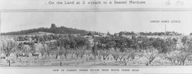
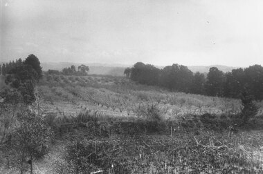
Photograph, Image used for land auction promotion of Garden Homes Estate between Mullum Mullum Road, Ringwood and Mullum Mullum Creek - 20/10/1923 , later developed to include The Centreway, Wattle Crescent, and Reserve Crescent, Ringwood
Black and white photograph of picture from subdivisional brochure. Picture shows orchard in foreground with a hill towards background. Treed area in the middle with a few houses scattered amongst them. To right of picture is printed, "Garden Homes Estate" with an arrow pointing to land. Printed above picture, "On the Land at 3 o'clock in a Seated Marquee. Typed below picture, "View of Gard -
 Ringwood and District Historical Society
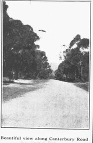
Photograph, Image used for land sale promotion of Coleman's Heathmont Estate, looking east along Canterbury Road, Heathmont. Sale 15/12/1923 by Public Auction
Catalogue card reads, "Coleman's Heathmont Estate - 1923. Sale 15/12/1923." -
 Ringwood and District Historical Society
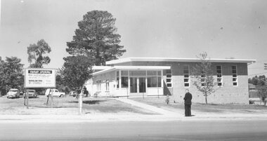
Photograph, Salvation Army Hall, Wantirna Road Ringwood, 1965
Black and white photograph of church with man standing outside. Sign stating, "Grand Opening" out front.Written on backing sheet, "Feb. 1965. Sal. Army Hall" -
 Ringwood and District Historical Society
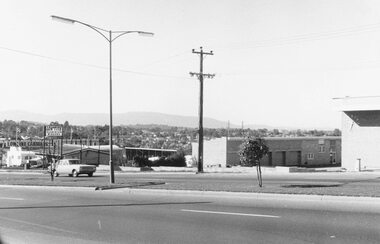
Photograph, Maroondah Highway West, Ringwood- 1969. Looking east from Heatherdale Road
Black and white photographWritten on back of photograph: "May, 1969" -
 Ringwood and District Historical Society
Photograph, View towards library in Warrandyte Road being built, across creek. c.1969. Two photographs
Written on back of photograph, "View towards library being built, across creek." -
 Ringwood and District Historical Society
Photograph, Library being built in Warrandyte Road opposite Eastland prior to opening in 1970
Written on back of photograph, "Library being built". -
 Ringwood and District Historical Society
Photograph, Two photos of Panfield Estate, owned by Vic Hunter sold by Miles & Co. - view from Panfield Avenue looking to Mullum Road, c.1963-65
Two photos - various inscriptions. "This (first) photo is RHS partner of V15" "Panfield Estate 1960. Panfield Ave. to Mullum Rd." "1965. Panfield Estate owned by Vic Hunter sold by Miles & Co." and second photo has written below photograph,"This photo is LHS partner of V11". Written on backing sheet,"Panfield Estate looking to Mullum Rd, 1963". -
 Ringwood and District Historical Society
Photograph, Godbehear's orchard in Warrandyte Road North Ringwood, prior to subdivision. (undated)
Typed below photograph, "Godbehear's orchard prior to subdivision". -
 Ringwood and District Historical Society
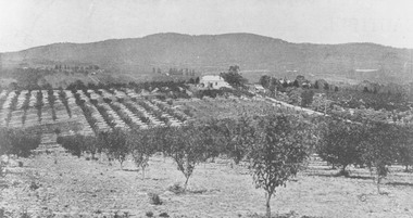
Photograph, View from Canterbury Road/Balfour Avenue area overlooking Martell's orchard, Heathmont, 1929
Black and white photograph of orchard. House in middle range, mountains in background. Photograph appears to be reproduced from subdivisional brochure. Note inserted in sleeve reads, "It has been pointed out that the mountains are to the east and the view is looking south. This therefore is not a 'straight' photograph. House still exists in Eden Avenue at October, 1996".(3 copies).Typed below photograph, "Panoramic view taken on the estate". "View overlooking Martell's orchard, Heathmont, 1929". Taken from corner Canterbury Rd. and Balfour Ave. looking south. Dandenong Creek just beyond house. Washusen Rd. on right". Written on back of one of the copies, "Heathmont Station Estate 1922". "Station Street, Lisgoold St. Canterbury Rd. Vivienne Cres. Balfour Ave." -
 Ringwood and District Historical Society
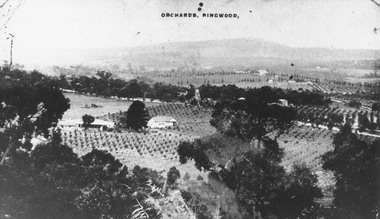
Photograph, View of Ringwood from Loughnans Hill. Pollards tank stand (centre) is on south side of Warrandyte Road. (Later location of Lauriston Crt.)
Black and white photograph looking down on orchards. House in centre of photograph, mountains in background. (3 copies)Written on back of one photograph, "Pollards tank stand" (centre) -
 Ringwood and District Historical Society
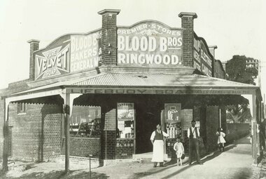
Photograph, Blood Bros. store in Bedford Road, Ringwood, opposite Greenwood St. 1921
Typed below photograph, "Blood Bros. store in Bedford Rd. opposite end Greenwood St. 1921". -
 Ringwood and District Historical Society
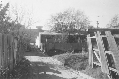
Photograph, Laneway between Adelaide Street and Warrandyte Road, looking towards S.E. Dickens supermarket on the corner of Civic Place. Ringwood, 1962
Black and white photograph of laneway. Dilapidated paling fences either side in foreground.On reverse of one photo: "Laneway from opp. Civic Pl. in Adelaide St to W'dyte Rd. 1962. Ringwood Historical Research Group" -
 Ringwood and District Historical Society
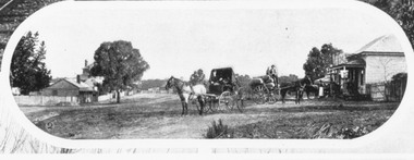
Photograph, Mount Dandenong Road, Ringwood. Blood's store on right, Club Hotel behind tree, Cornell's store on left. c.1900-1910
Written on backing sheet, "Blood's store on right, Club Hotel behind tree, Cornell's store on left". -
 Ringwood and District Historical Society
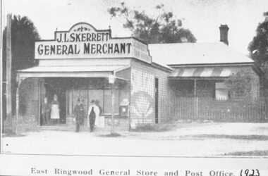
Photograph, Skerrett's Store and Post Office, 1923. Diagonally opposite from Club Hotel in Mount Dandenong Road
Catalogue card reads, "Skerrett's Store and Post Office, 1923. Diagonally opposite from Club Hotel." -
 Ringwood and District Historical Society
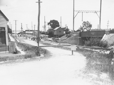
Photograph, Subway construction at Warrandyte Road, Ringwood 1923. Taken from Pitt St
Typed below photograph, "Making Warrandyte Rd. subway 1923. Taken from Pitt St." -
 Ringwood and District Historical Society
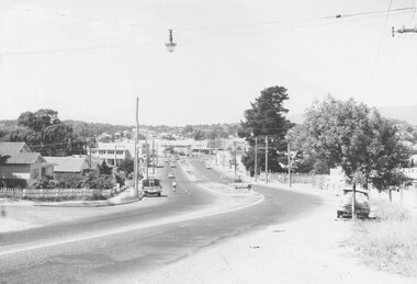
Photograph, Maroondah Highway West, Ringwood- 1960. Looking east from Heatherdale Road
Black and white photographWritten on back of photograph: "Maroondah Highway coming into Ringwood, 1960". -
 Ringwood and District Historical Society
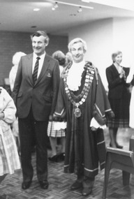
Photograph, City of Ringwood Chief Executive, Mr. Alan Robertson (left), and Mayor Cr. Bill Wilkins attending the opening of "Lionsbrae" aged care facility, Everard Road Ringwood East - 17/11/1985
Black and white photograph Mr. Alan Robertson (left), Mayor Cr. Bill Wilkins. Partly obscured Cr. Betty Milton. -
 Ringwood and District Historical Society
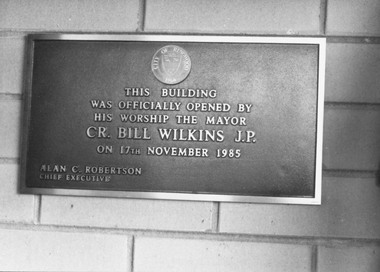
Photograph, Foundation stone at "Lionsbrae" aged care facility, Everard Road Ringwood East - 17/11/1985
Catalogue card reads, 'Foundation stone at "Lionsbrae", 17/11/1985'."This building was officially opened by His Worship The Mayor Cr. Bill Wilkins J.P. on 17th November 1985 - Alan C. Robertson Chief Executive" -
 Ringwood and District Historical Society
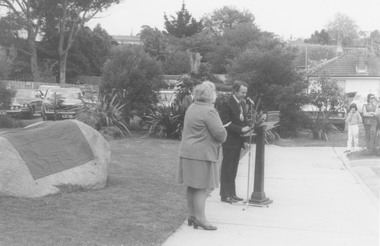
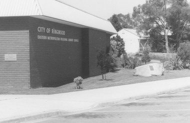
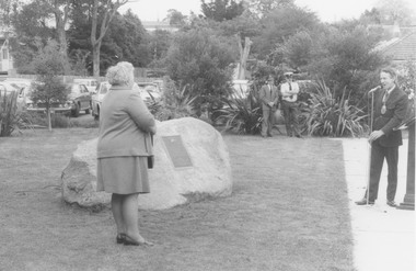
Photograph, Plaque unveiling at Ringwood Eastern Metropolitan Regional Library, Warrandyte Road, Ringwood on 26/10/1974, marking the Golden Jubilee of Ringwood's severance from Lilydale. Mrs. E Pullin, Ringwood Historical Group President (left), and Mayor, Cr. Stan Morris
Catalogue card reads, 'Library. Unveiling stone outside library to commemorate Matthew Flinders explorers and early graves of settlers, 1970'. Back of photograph reads, 'Unveiling of plaque, 1970. Cr. Stan Norris and E. Pullin'. -
 Ringwood and District Historical Society
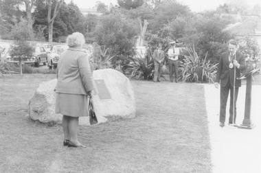
Photograph, Plaque unveiling at Ringwood Eastern Metropolitan Regional Library, Warrandyte Road, Ringwood on 26/10/1974, marking the Golden Jubilee of Ringwood's severance from Lilydale
Catalogue card reads, 'Library - unveiling stone outside library to commemorate Matthew Flinders explorers and early graves of settlers, 1970'. Written on back of photograph, '1970 - Rock and plaque, Cr. Stan Morris, Mayor'. -
 Ringwood and District Historical Society
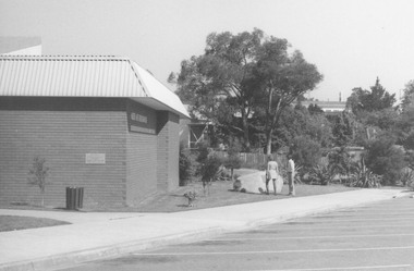
Photograph, Plaque unveiling at Ringwood Eastern Metropolitan Regional Library, Warrandyte Road, Ringwood on 26/10/1974, marking the Golden Jubilee of Ringwood's severance from Lilydale
Catalogue card reads, 'Library unveiling stone outside library to commemorate Matthew Flinders explorers and early graves of settler, 1970'. Written on back of photograph, 'Library 1970'. -
 Ringwood and District Historical Society
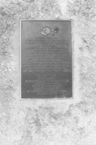
Photograph, Plaque unveiling at Ringwood Eastern Metropolitan Regional Library, Warrandyte Road, Ringwood on 26/10/1974, marking the Golden Jubilee of Ringwood's severance from Lilydale
Written on back of photograph, 'Plaque and rock 1970. Ringwood Library'. Catalogue card reads, 'Library - Unveiling stone outside library to commemorate Matthew Flinders, explorers and early graves of settlers, 1970.' -
 Ringwood and District Historical Society
Photograph, Plaque unveiled at Ringwood Eastern Metropolitan Regional Library, Warrandyte Road, Ringwood on 26/10/1974, marking the Golden Jubilee of Ringwood's severance from Lilydale
Written on back of photograph, 'Plaque, 1970'. -
 Ringwood and District Historical Society
Photograph, Plaque unveiling at Ringwood Eastern Metropolitan Regional Library, Warrandyte Road, Ringwood on 26/10/1974, marking the Golden Jubilee of Ringwood's severance from Lilydale. Mrs. E Pullin, Ringwood Historical Group President (left), and Mayor, Cr. Stan Morris
Written on catalogue card, 'Library. Unveiling stone outside library to commemorate Matthew Flinders explorers and early graves of settlers, 1970.' Written on back of photograph, 'Mayor Cr. Stan Morris dedication rock plaque outside library 1970'. -
 Ringwood and District Historical Society
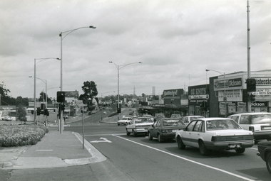
Photographs, Ringwood shops along Maroondah Hwy from Ringwood St to Warrandyte Road in 1997
491_001 - east of Melbourne St 491_002 - Melbourne St, showing old library at end 491_003 - shops 491_004 - old State Bank -
 Ringwood and District Historical Society
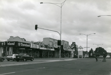
Photographs, Looking wes along Maroondah Hwy, Ringwood corner of Wantirna Road in 1997
-
 Ringwood and District Historical Society
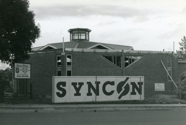
Photographs, Redevelopment of Ringwood Salvation Citidel, Wantirna road, in 1997
-
 Ringwood and District Historical Society
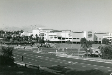
Photographs, Eastland in 1997, corner of Warrandyte Road and Ringwood Bypass
Showing City of Ringwood Bowling Club being demolished