Showing 50188 items matching " coat-of-arms"
-
 Wangaratta RSL Sub Branch
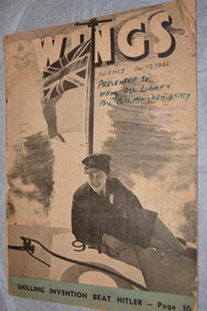
Magazine - RAAF Magazine, Directorate of Public Relations RAAF, WINGS, 12/12/1944
... Directorate of Public Relations RAAF ...Official RAAF Magazine issued fortnightly during WW2 between April 1943 to March 1946In publication since 1942, Wings delivers an informative and entertaining collation of Australia's proud aviation history, the latest aerospace research and technology, aviation industry and military news, encouragement for our junior leaders and engagement with the veteran community.Grey and white magazine with photograph of WREN on a boat at sea.Vol 4 No 5 Dec. 12, 1944 wings, raaf, magazine, ww2 -
![Map, Liquidator's sale, 1896. [Woolpack Estate, Bacchus Marsh]](/media/collectors/5e461d8021ea67224c82f2a1/items/6779ee97032b72846b5995f2/item-media/6779ef33032b72846b599b30/item-fit-380x285.jpg) Bacchus Marsh & District Historical Society
Bacchus Marsh & District Historical SocietyMap, Liquidator's sale, 1896. [Woolpack Estate, Bacchus Marsh]
... Shire of Bacchus Marsh ...The Woolpack Estate was an area of land owned by various landowners in the Bacchus Marsh area since the early Colonial period of the 1840s. The area was located on the eastern side of the Bacchus Marsh township about 7 kilometers from the town. The Lerderderg River ran through part of the land and so did the Melbourne to Ballarat Road. The historic Woolpack Inn associated with James Crook was also located on this land. By 1896 150 acres of this land was under the control of liquidators for the Federal Bank of Australasia who instructed that the land be sub-divided and sold in lots by public auction. A successful sale was held on 24 June 1896. Most of the blocks of land were sold for higher than expected prices and most of the buyers were people from the town and district of Bacchus Marsh. The map includes various details about the land which is described on the map as an "important sale of rich alluvial irrigable flat land in the Bacchus Marsh Valley, and other properties". The auction was conducted by the local agents W. Anderson and Bence in conjunction with Pearce Brothers also of Bacchus Marsh.A single page paper map showing a plan of 150 acres of land from the Woolpack Estate to be sold in various lots in June 1896. Also shown on the map are lots for sale at Robinson's Farm on Coimadai Creek and allotments near Bacchus Marsh railway station, including lots on Government Road (East Maddingley Road), View Street and Government Road (Parwan Road). No scale provided. The map is pasted into a bound volume containing 76 maps or plans in total. High resolution digital image stored on BMDHS computer network. land sales bacchus marsh, bacchus marsh victoria maps, woolpack estate bacchus marsh victoria -
 Bacchus Marsh & District Historical Society
Map, Bacchus Marsh Tuesday 23rd Oct. 1888, Lodge & Dunn's Paddocks 1888. Business and Mansion Sites
... Shire of Bacchus Marsh ...This map was created as a plan for an auction of land close to the Bacchus Marsh Railway Station. The auction took place on 23 October 1888. 102 allotments of land from an area known as Lodge and Dunn's paddocks was offered for sale. The auction was conducted by auctioneers based in Melbourne and was advertised in Melbourne newspapers as well as in the Bacchus Marsh Express newspaper. The auction plan contains a range of details including the selling agents, Munro and Baillieu; W.P. Lockhart; and John Turner, all of Melbourne, deposit terms for purchases, price of railway passes for a return trip from Melbourne to Bacchus Marsh of 1 shilling, and a description of the land as having 'magnificent views and perfect drainage'. A single page paper map showing allotments of land for sale along the Parwan Road in Maddingley. The map is pasted into a bound volume containing 76 maps or plans in total. High resolution digital image stored on BMDHS computer network. At bottom on left side: 'Harston & Co. Lith, Melb.'land sales bacchus marsh, land sales maddingley, bacchus marsh victoria maps, maddingley victoria maps -
 Bacchus Marsh & District Historical Society
Map, Bacchus Marsh Suburban Allotments Parwan Road Lodge & Dunn's Paddocks 1888
... Shire of Bacchus Marsh ...This map was created as a plan for an auction of land close to the Bacchus Marsh Railway Station. The auction took place on 23 October 1888. 102 allotments of land from an area known as Lodge and Dunn's paddocks was offered for sale. A single page paper map showing allotments of land for sale along the Parwan Road in Maddingley. The map is pasted into a bound volume containing 76 maps or plans in total. High resolution digital image stored on BMDHS computer network. land sales bacchus marsh, land sales maddingley, bacchus marsh victoria maps, maddingley victoria maps -
 Linton and District Historical Society Inc
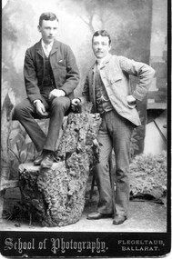
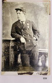
Photograph, School of Photography Flegeltaub, Ballarat, Richard and Thomas Kennedy
... School of Photography Flegeltaub, Ballarat ...Sepia photograph of two young men wearing suits, one seated on tall object with left arm resting in knee, right arm resting on left, the other with fob chain, standing, leaning right arm on object, left arm crooked onto waist."Richard (born c1864, married Catherine Honora O'Beirne on 7.4.1890) and Thomas Kennedy, taken while they lived at Fingal Park and managed it with the help of 2 sisters. The Family were still in Portland. Richard (Dick) was secretary with our Mother and organiser of the very first concert at Linton. Proceeds were in aid of a church organ which I believe is still there. HB Mrs Barry"richard kennedy, thomas kennedy, fingal park, catherine o'beirne -
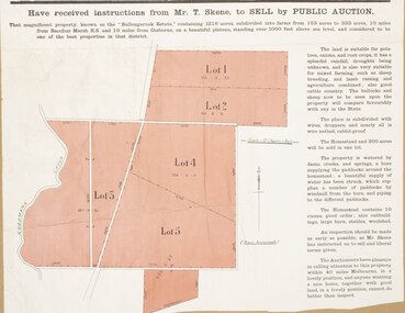
 Bacchus Marsh & District Historical Society
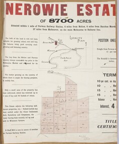
Map, Nerowie Estate Land Sale 1910
... Shire of Bacchus Marsh ...The Nerowie Estate was a large rural property of 8,700 acres (3520 hectares) near the locality of Parwan only a few kilometers east of Bacchus Marsh. It had once formed a large part of the land owned by the pioneering Staughton family.A single page paper map showing the land offered for sale from the Nerowie Estate at Parwan near Bacchus Marsh in 1910. The map is pasted into a bound volume containing 76 maps or plans in total. High resolution digital image stored on BMDHS computer network. nerowie estate parwan, land sales parwan, land sales bacchus marsh, staughton family bacchus marsh -
 Eltham District Historical Society Inc
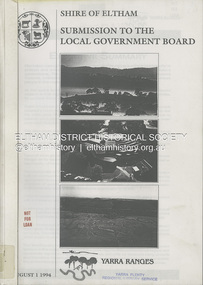
Book, Shire of Eltham, Submission to the Local Government Board: Yarra Ranges, 1 August 1994
... Shire of Eltham ...A restructure proposal by the Shire of Eltham, named the municipality of Yarra Ranges, reflects a strategic focus. It has natural boundaries and a strong sense of place built on communities of interest. Prepared in consultation with the community and neigbouring municipalities of Diamond Valley and Heidelberg. Contents include: Principles for change, rationale for the proposal, mergers and other restructure proposals. Appendices include: community consultation, Metropolitan Green Wedge Strategy, Constituent Council Benchmark, external refernce benchmark - Moreland, communities of interest, conservation and landcare groups, social profile, key financial management strategies and more.54 pages, 11 Appendicesnon-fictionA restructure proposal by the Shire of Eltham, named the municipality of Yarra Ranges, reflects a strategic focus. It has natural boundaries and a strong sense of place built on communities of interest. Prepared in consultation with the community and neigbouring municipalities of Diamond Valley and Heidelberg. Contents include: Principles for change, rationale for the proposal, mergers and other restructure proposals. Appendices include: community consultation, Metropolitan Green Wedge Strategy, Constituent Council Benchmark, external refernce benchmark - Moreland, communities of interest, conservation and landcare groups, social profile, key financial management strategies and more.local government, municipal restructuring, council amalgamation -
 Bendigo Military Museum
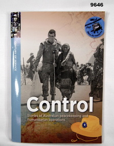
Book - NARRATIVES, PEACEKEEPING, Johanna Butler, "CONTROL", 2019
... Australian Government Department of Veteran Affairs ...From front cover; "CONTROL" "Stories of Australian peacekeeping and humanitarian operations". Part of "The Century of Service series".Soft Cover Book. Cover - cardboard, white and pale blue print on front and back. Illustrated front montage, black and white photograph of soldier in uniform assisting a civilian, above colour map and yellow hat. Back montage in colour and black and white three photographs and two maps and cloth shoulder insignia. 52 pages - cut, plain, white coloured paper. Illustrated, colour and black and white photographs, maps, sketches and newspaper cuttings. Pictorial type book. End papers - illustrated. Spine fastened with two metal staples.publication, book, peacekeeping and operations -
 Flagstaff Hill Maritime Museum and Village
Photograph - Portrait, late 19th century
... Photographic Society of Victoria ...This photograph is of Tom Pearce, one of only 2 survivors from the shipwreck LOCH ARD. Loch Ard was bound for Melbourne in 1878 loaded with passengers and cargo when it ran into a rocky reef at the base of Mutton Bird Island, near Port Campbell. Of the 54 crew members and passengers on board, only two survived: an apprentice, Tom Pearce and a young woman passenger, Eva Carmichael, who lost all of her family in the tragedy. Coleman Jacobs composed the music “The Young Hero Schottische” and dedicated it, by permission, to Mr. Thomas R. (Tom) Pearce. The sheet music was published in 1878 by the Messieurs Roberts, professors of dancing etc. Melbourne. It was on sale for 3/- (3 shillings) and in aid of the “LOCH ARD” fund. [This is Coleman Jacobs’ only surviving musical work Coleman Jacobs, accomplished pianist, musical performer, singer, composer, professor of music and music teacher, was born in 1827 and died on 4 July 1885, aged 58 years. Coleman Jacobs was buried in the Melbourne Cemetery (grave 461, Church of England section).] The wreck of Loch Ard still lies at the base of Mutton Bird Island and much of the cargo has been salvaged. Some was washed up into what is now known as Loch Ard Gorge following the shipwreck. Cargo and artefacts have also been illegally salvaged over many years before protective legislation was introduced. The photograph is significant for its association with the wreck of the Loch Ard. This wreck has been protected as a Historic Shipwreck since 11 March 1982, under the Commonwealth Historic Shipwrecks Act (1976) Flagstaff Hill’s collection of artefacts from Loch Ard is significant for being one of the largest collections of artefacts from this shipwreck in Victoria. It is significant for its association with the shipwreck, which is on the Victorian Heritage Register. The collection is significant because of the relationship between the objects, as together they have a high potential to interpret the story of the Loch Ard. The Loch Ard collection is archaeologically significant as the remains of a large international passenger and cargo ship. The Loch Ard collection is historically significant for representing aspects of Victoria’s shipping history and its potential to interpret sub-theme 1.5 of Victoria’s Framework of Historical Themes (living with natural processes). The collection is also historically significant for its association with the Loch Ard, which was one of the worst and best known shipwrecks in Victoria’s history. The Loch Ard collection meets the following criteria for assessment: Criterion A: Importance to the course, or pattern, of Victoria’s cultural history. Criterion B: Possession of uncommon, rare or endangered aspects of Victoria’s cultural history. Criterion C: Potential to yield information that will contribute to an understanding of Victoria’s cultural history. Photograph of Mr Tom Pearce dressed in a uniform with a medal pinned on it. Standing with his arm resting on a masonry pillar. Reverse has piece of tape centre top and bottom. Also has printed maker’s information. Printed by the Photographic Society of Victoria, Melbourne.Printed green text “PHOTOGRAPHIC / SOCIETY OF VICTORIA / MELBOURNE / REGISTERED COPYRIGHT / JULY 24th 1878” and “NONE ARE GENUINE UNLESS WITH / SIGNATURES THUS” and “PRESIDENT / VICE PRESIDENT / SECRETARY” flagstaff hill, warrnambool, shipwrecked coast, flagstaff hill maritime museum, maritime museum, shipwreck coast, flagstaff hill maritime village, loch ard shipwreck, tom pearce, thomas r pearce, eva carmichael, mutton bird island, loch ard survivor, loch ard hero, coleman jacobs, the young hero schottische, photograph of tom pearce -
 Bacchus Marsh & District Historical Society
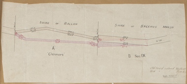
Map, Road plan deviation near Glenmore
... Shire of Bacchus Marsh ...This plan shows a proposed deviation in the road near Glenmore. This is likely to have been the Bacchus Marsh to Ballan road. The precise date of the plan has not been established. Proposed deviations to the road near Glenmore appear in reports in the Bacchus Marsh Express newspaper through many decades, especially in the 1870s and 1880s. Glenmore is located 19 kilometers west of Bacchus Marsh.A single page paper map showing a plan for a road deviation near Glenmore Station. Scale 5 chains to 1 inch. Date of production unknown. Circa 1860s-1890s. The map is pasted into a bound volume containing 76 maps or plans in total. High resolution digital image stored on BMDHS computer network. Old road colored Yellow, New road colored Pinkroad plans, road construction, glenmore victoria maps -
 Bacchus Marsh & District Historical Society
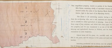
Map, Pentland Hills Estate Land Sale 1904
... Shire of Bacchus Marsh ...The Pentland Hills Estate property shown in this auction plan was put up for sale in 1904. It was a deceased estate sale. The property had been owned by Peter Grant who died in 1899. Peter Grant had worked and farmed in the Myrniong area for many years and had also been a Councillor on the Bacchus Marsh Shire for a number of terms. A property sales report in the Express newspaper recorded that the land for sale comprised 500 acres of the old Pentland Hills Estate. It was subdivided into three lots, all of which were sold at good prices. Lot l, 212 acres was sold to Messrs Thomas and Robert Lidgett of Myrniong, at £11/15/ per acre, lot 2, 200 acres, to Mr David Robertson, of Bacchus Marsh, at £9 17/0 per acre, and lot 3, 38 acres, was sold to Mr James Norton, jun at £11 per acre. A single page paper map showing a portions of land available for sale from the Pentland Hills Estate near Bacchus Marsh.The name of the seller, Mrs Grant, can seen handwritten on this map and the buyers of the three portions for sale, Lidgett lot 1, Robertson lot 2 and Morton lot 3. Parts of the text are missing along the edges due to tearing or excessive trimming of the edges. The map is pasted into a bound volume containing 76 maps or plans in total. High resolution digital image stored on BMDHS computer network. Handwritten: Mrs Grant, Myrniong, Executrix in the deceased Estate of Mr. Peter Grant to sell by public auction.land sales, pentland hills maps, myrniong area land sales, pentland hills estate -
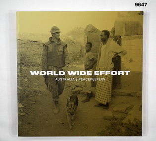 Bendigo Military Museum
Book - NARRATIVES, PEACEKEEPING, Dr Ian Hodges, "WORLD WIDE EFFORT/AUSTRALIA'S PEACEKEEPERS", 2022
... Australian Government Department of Veteran Affairs ...Soft cover book.. Cover - cardboard, white colour print on front, spine and back. Illustrated, front black and white photograph of soldier with dog and two civilians on yellow colour background. 126 pages, cut, plain, white colour paper. Illustrated, pictorial section. Pags 20 to 123. Colour and black and white photographs. front and end papers - illustrated.publication, book, peace keepers, pictorial -
 Bacchus Marsh & District Historical Society
Map, Bullengarook Estate Property Sale. 1911
... Shire of Bacchus Marsh ...Bullengarook is a locality located 19 kilometers north of Bacchus Marsh. Pastoral leases for European colonists were granted to people for this area from around the 1840s.The Bullengarook Estate was part of these early pastoral holdings. By the 1900s the property had been owned by the Skene family for a number of years. In early 1911 the property then consisting of 300 acres and the homestead upon it was offered for sale in one lot. It appears however that the sale of the property did not go through in 1911. It was later leased by Thomas Skene to a Mr Coutts in 1915 and ultimately and at a later stage the property was sold by the Skene family.A single page paper map showing land allotments for sale from the Bullengarook Estate. The map is pasted into a bound volume containing 76 maps or plans in total. High resolution digital image stored on BMDHS computer network. land sales bacchus marsh, bullengarook land sales, bullengarook estate, bullengarook vic history -
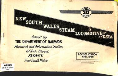 Victorian Railway History Library
Book, New South Wales Department of Railways, New South Wales Steam Locomotive Data, 1966
... New South Wales Department of Railways ...Data on steam locomotives of the New South Wales Railway in April 1966.p.50.non-fictionData on steam locomotives of the New South Wales Railway in April 1966.railroad operations - new south wales - history, locomotives - new south wales - history -
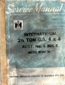 National Vietnam Veterans Museum (NVVM)
Manual - l, National Harvester Co. of Aust, Service Manual: International 2.5 Ton GS 4x4: Aust. No.1 MK4 With Winch
... National Harvester Co. of Aust. ...A blue and white coloured cardboard covr with black and white details on the front. At the top in white reads Service Manual with the Intetantional logo under this. Down at the bottom of the cover in black reads International Harvester Company of Australia Pty. Ltd. The manual is held together with tape.international truck cargo f1, service manual -
 University of Melbourne, Burnley Campus Archives
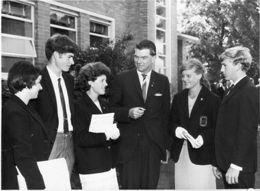
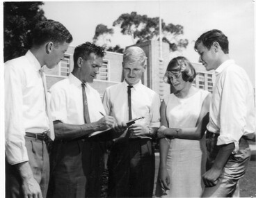
Photograph - Black and white print, Publicity Branch Victorian Department of Agriculture, Graduation Day Mid 1960's, 1970-1980
... Publicity Branch Victorian Department of Agriculture ...2 very similar black and white photographs. 5 students wearing blazers, with a man (Dept. of Agriculture?) standing in front of the Administration Building. It appears to be Graduation Day.On reverse, "Photograph by Publicity Branch Victorian Department Of Agriculture Ref. No. D826A and B."students, blazers, administration building, graduation day, publicity, dept of agriculture -
 University of Melbourne, Burnley Campus Archives
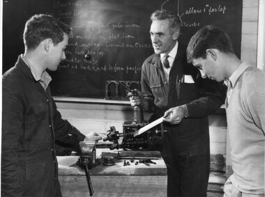
Photograph - Black and white print, Publicity Branch Victorian Department of Agriculture, Mechanics Class, 1960-1970
... Publicity Branch Victorian Department of Agriculture ...Black and white photograph. George Grumont and 2 male students in the old Engineering Workshop. Writing on a blackboard in the background.On reverse, "Photograph by Publicity Branch Victorian Department Of Agriculture Ref. No. D.162.E."george grumont, students, engineering workshop, students in class, publicity, dept of agriculture -
 Bacchus Marsh & District Historical Society
Map, Main Road and Gell Street Allotments
... Shire of Bacchus Marsh ...This map shows allotments of land along Gell Street Bacchus Marsh running between Main Road (now called Main Street) and Lerderderg Street. The total area of the map encompasses Main Road, Church Street, Lerderderg Street and Gell Street. 36 allotments of land are shown. Three allotments which connect to Main Road are shaded in pink. The date of the map has not been established but the National Bank building erected in 1865 near the Border Inn is indicated which indicates that the map dates from after 1865. Reports in the Bacchus Marsh Express newspaper on 5 March 1870, page 2, column 6 announced building lots in Gell Street had been withdrawn from sale by the agent J.E. Crook. Later reports in the Express on 1 November 1873, page 2, column 2 advertised 14 allotments of land in Gell Street for sale. Single page map showing allotments of land along the Main Road (Main Street) and Gell Street areas of Bacchus Marsh. Part of a set of maps which are pasted into a bound volume containing 76 maps or plans in total. High resolution digital image stored on BMDHS computer network. bacchus marsh victoria maps, gell street land allotments, main street land allotments -
 Bacchus Marsh & District Historical Society
Map, Gaynor Street Area Land Sales, Maddingley, 1888
... Shire of Bacchus Marsh ...This map was produced for a major sale of land in the Maddingley area of Bacchus Marsh in 1888. The sale was conducted by two firms from Melbourne, Carney and Kelly 12 Swanston Street Melbourne. and 'Richardson, Kerr & Co. 40 Flinders Lane Melbourne. 136 blocks were for sale.A single page paper map showing land allotments for sale in the Maddingley area of Bacchus Marsh. Locations shown include Gaynor Street, Maddingley Road South, Parwan Road, Mitchem Street, Typpynge Street, Finn Street and East Maddingley Road. . The map is pasted into a bound volume containing 76 maps or plans in total. High resolution digital image stored on BMDHS computer network. bacchus marsh victoria maps, maddingley victoria maps, land use, maddingley victoria history, land sales bacchus marsh, land sales maddingley -
 Bacchus Marsh & District Historical Society
Map, Gaynor Street Land Sales, Maddingley, circa 1880s-1890s
... Shire of Bacchus Marsh ...This map was produced for a major sale of land in the Maddingley area of Bacchus Marsh. The precise date of the sale has not been determined. Features present on the map such as the Bacchus Marsh Railway Station indicate the land sale must have taken place some time after 1887 when the Railway Station opened. A single page paper map showing land allotments for sale in the Maddingley area of Bacchus Marsh. Locations shown include Gaynor Street, Maddingley Road South, Parwan Road, Mitchem Street, Typpynge Street, Finn Street and East Maddingley Road. . The map is pasted into a bound volume containing 76 maps or plans in total. High resolution digital image stored on BMDHS computer network. bacchus marsh victoria maps, maddingley victoria maps, land use, maddingley victoria history, land sales bacchus marsh, land sales maddingley -
 Bacchus Marsh & District Historical Society
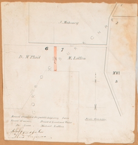
Map, Land required for a public highway near Rowsley, Victoria. Circa 1880s
... Shire of Bacchus Marsh ...This map indicates portions of land in the Parish of Gorrockburkchap near Rowsley which was required for construction of a road. The land required was leased to a Michael Laffan. Other blocks of land nearby owned or leased by D. McPhail and J. Mahoney are also indicated on the map. The date of the map is not known. However newspaper reports in the Bacchus Marsh Express on the 18 March 1882, page 3, column 3 mention land occupied by McPhail and Laffan near Rowsley in connection to the construction of a public road.Single page map showing land occupied by farmers D. McPhail and Michael Laffan which was required for a public highway. Scale 6 chains to inch. Part of a set of maps which are pasted into a bound volume containing 76 maps or plans in total. High resolution digital image stored on BMDHS computer network. Signed by Shire Engineer, W.E. Standfieldrowsley victoria maps -
 Bacchus Marsh & District Historical Society
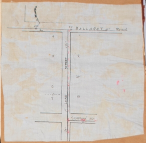
Map, Lord Street, Bacchus Marsh. Undated
... Shire of Bacchus Marsh ...A small single page map showing the line of Lord Street Bacchus Marsh between Ballarat Road (Main Street) and Simpson Street. Part of a set of maps which are pasted into a bound volume containing 76 maps or plans in total. High resolution digital image stored on BMDHS computer network. bacchus marsh victoria maps, lord street bacchus marsh maps -
 Bacchus Marsh & District Historical Society
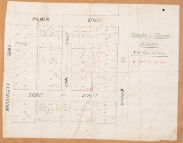
Map, Bacchus Marsh Estate sold 30th June 1888 and sold 28 December 1895
... Shire of Bacchus Marsh ...Blocks of land in this area of Bacchus Marsh were sold in lots between 1888 and the late 1890s. This map shows sales made in 1888 and 1895.Single page map showing allotments of land bounded by Pilmer Street, Graham Street, Sydney Street and Maddingley Road (Grant Street) in Bacchus Marsh.The area is dissected by Como Street down the central area. 43 blocks of land are shown with the names of buyers or sellers in 1888 written in black in. Buyers or sellers for December 1895 are written in red ink. Part of a set of maps which are pasted into a bound volume containing 76 maps or plans in total. High resolution digital image stored on BMDHS computer network. bacchus marsh victoria maps, land sales bacchus marsh, pilmer street bacchus marsh, graham street bacchus marsh, sydney street bacchus marsh, como street bacchus marsh, maddingley road bacchus marsh, grant street bacchus marsh -
 University of Melbourne, Burnley Campus Archives
Photograph - Black and white print, Publicity Branch Victorian Department of Agriculture, Students in Outside Class, c. 1965
... Publicity Branch Victorian Department of Agriculture ...Black and white photograoh. 4 students gathered around Bill Nicholls (Field Superintendent) who is holding a clipboard. Administration building in the background. On reverse, "Photograph by Publicity Branch Victorian Department Of Agriculture Ref. No. D.477.A."students, bill nicholls, field superintendent, w.j. nicholls, outside class, dept of agriculture, publicity -
 University of Melbourne, Burnley Campus Archives
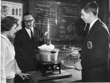
Photograph - Black and white print, Publicity Branch Victorian Department of Agriculture, Laboratory Class, c. 1962
... Publicity Branch Victorian Department of Agriculture ...Black and white photograph. A.J. Farrance (Biological Sciences, holding a test tube)with 2 students in the Laboratory. Writing on blackboard in the background.On reverse, "Photograph by Publicity Branch Victorian Department Of Agriculture Ref. No. D.162.B."a.j. farrance, biological sciences, students, laboratory, students in class, publicity, dept of agriculture -
 University of Melbourne, Burnley Campus Archives
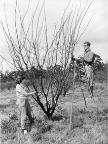
Photograph - Black and white print, Publicity Branch Victorian Department of Agriculture, Students Pruning Fruit Trees, 1960-1970
... Publicity Branch Victorian Department of Agriculture ...Black and white photograph. 2 students pruning a fruit tree with secateurs. One on a metal ladder.On reverse, "Photograph by Publicity Branch Victorian Department Of Agriculture Ref. No. c.1695H."students, pruning, fruit trees, orchard, secateurs, ladder, publicity, dept of agriculture -
 Clunes Museum
Book, DEPARTMENT OF VETERAN'S AFFAIRS, SNAPSHOTS - AUSTRALIANS IN WAR AND CONFLICT, 2024
... DEPARTMENT OF VETERAN'S AFFAIRS ...AUSTRALIA'S SERVICE HISTORY IS MUCH MORE THAN A SERIES OF MILITARY EVENTS. IT IS A RICH TAPESTRY OF PERSONAL STORIES TO TELL AND RETELL...SOFT COVER BOOK WITH VARIOUS WAR RELATED IMAGES OF SERVICE PEOPLE IN MONTAGE, CENTRAL IMAGE IS OF A CAMERA LENS 60 PAGESnon-fictionAUSTRALIA'S SERVICE HISTORY IS MUCH MORE THAN A SERIES OF MILITARY EVENTS. IT IS A RICH TAPESTRY OF PERSONAL STORIES TO TELL AND RETELL...australian war and conflict, australian defence services personnell -
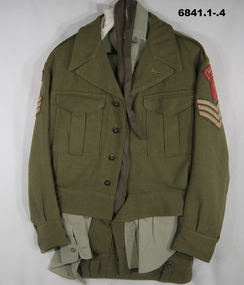 Bendigo Military Museum
Uniform - BATTLE DRESS, ARMY, 1953 - 1970
... Department of Defence ...1. Battle Dress Jacket. Wool Khaki. It has Sgts Stripes, on each shoulder are cloth badges. 3 Div and Northern Victorian Rgt. The jacket has two breast pockets and a purpose made cloth belt. 2. Trousers Battle dress. Wool, khaki. Fly held shut with five buttons. Brown buttons hold belt loops. 3. Shirt, polyester. light Khaki. Long sleeve. Two breast pockets held shut with brown buttons. 4. Tie, light brown. 5. Hat, Khaki fur felt. It has a silver hat badge of 38 Battn - Motto HONOREM CUSTODITE.Inside shirt collar has letters. “R.W” written in ink. Written in texta, inside leather band is: - “Atkinson 2794820”38 bn, post ww2, cmf, passchendaele barracks trust -
Port Melbourne Historical & Preservation Society
Negative - All England Eleven Hotel, Melbourne and Metropoltan Board of Works, 1950
... Melbourne and Metropoltan Board of Works ...2 oblong negatives of the "All England Eleven Hotel"built environment - commercial, business and traders - hotels, all england eleven hotel -
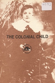 Ringwood and District Historical Society
Book, The Colonial Child, 1979
... Royal Historical Society of Victoria ...Booklet documenting some aspects of life of Australian children in the 19th century comprising papers presented at the 8th Biennial Conference of the Royal Historical Society of Victoria in Melbourne, 12-13 October 1979.