Showing 200 items matching " bendigo agricultural society"
-
 Bendigo Historical Society Inc.
Map - CAMPBELL COLLECTION: BENDIGO AND DISTRICT MAPS
Map. Sedgwick. Parishes of Strathfieldsaye, Lyell and Sedgwick. Scale 20 chains to 1 inch. (number 359 in map cupboard 1)map, bendigo, agricultural lands -
Bendigo Historical Society Inc.
Map - CAMPBELL COLLECTION: BENDIGO AND DISTRICT MAPS
Map. Eppalock, Sedgwick and Strathfieldsaye, scale 20 chains to 1 inch. Road to Bendigo 13 1/2 miles at top right of map, Longlea Railway Station 5 1/2 miles, Bendigo 11 miles, Strathfieldsaye 5 miles on left of map. Total area 3972 acres. Prepared in W.P.B. from Assessment Plan and Parish Plans. H.A. Darby 14-6-29.H.A.Darbymap, bendigo, agricultural lands -
Bendigo Historical Society Inc.
Map - CAMPBELL COLLECTION: BENDIGO AND DISTRICT MAPS
Map. Ellesmere, Parish of Ellesmere. Scale 20 chains to 1 inch. Total area 3926 acres. Prepared in W.P.B. from A and P plans. (number 354 in map cupboard 1)map, bendigo, agricultural lands -
Bendigo Historical Society Inc.
Map - CAMPBELL COLLECTION: BENDIGO AND DISTRICT MAPS, 8-2-29
Map. Bagshot, Parishes of Wellsford, Ellesmere and Bagshot. Scale 20 chains to 1 inch. Total area 5037 acres. Prepared in W.P.B. from A.C.l. and D.B. Plans, W.J. Galbraith, 8-2-29 (number 353 in map cupboard 1)W.J.Galbraithmap, bendigo, agricultural lands -
Bendigo Historical Society Inc.
Map - CAMPBELL COLLECTION: BENDIGO AND DISTRICT MAPS, 12-2-29
Map. Axedale, Parishes of Ellesmere and Axedale. Scale 20 chains to 1 inch. To the west is Wellsford. Total area 4156 acres. Prepared in W.P.B. from A and P plans by W.J. Galbraith 12-2-29. (number 352 in map cupboard 1)W.J.Galbraithmap, bendigo, agricultural lands -
Bendigo Historical Society Inc.
Map - CAMPBELL COLLECTION: BENDIGO AND DISTRICT MAPS
Map. Lyell, Parishes of Sedgwick, Eppalock and Lyell. Scale 20 chains to 1 inch. (number 348 in map cupboard 1)map, bendigo, agricultural lands -
 Bendigo Historical Society Inc.
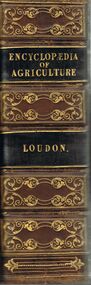
Book - AN ENCYCLOPAEDIA OF AGRICULTURE
A hard covered copy of 'Encyclopaedia of Agriculture.' Compiled by J. C. Loudon. 4th edition. London. Longman, Orme, Brown, Green and Longmans. Pasternoster-Raw, 1839. 1378 p. (ill.) Various items have been pasted in on the inside page.J.C. Loudonbooks, technical, agriculture, books, agriculture, reference, encyclopaedias, horticulture, animals, farming -
 Bendigo Historical Society Inc.
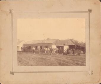
Photograph - GENERAL SMITH & AGRICULTURAL IMPLEMENT MAKER
Sepia photograph mounted on fawn board. Vertical board building and skillion. Two gable roof - open end under one gable. Large double doors (painted) under other gable. Small doors and windows with lift up shutters along side. Vehicles, wheels and 8 men in front of building. Small painted weatherboard building to L. Sign on front of building. Inscriptions: in image - 'Watkin Walker? & Treacy General Smith and Agricultural Implement Maker'.buildings, commercial -
 Bendigo Historical Society Inc.
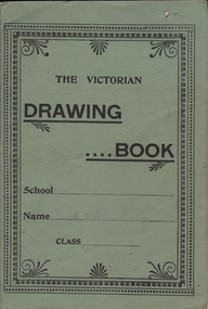
Document - BUSH COLLECTION: AGRICULTURAL SOCIETY ART ENTRY, 1911
Entry into Maffra Agricultural Society (Show) - Class Q Art Section 15 No. 3. A 'Victorian Drawing Book' entered by Merle Bush ( M. I.?. B in pencil on cover) - 12 pages of school drawing. Under 16 years. Agricultural Society entry card is inside front cover.person, individual, bush collection - personal -
 Bendigo Historical Society Inc.
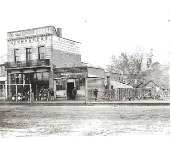
Photograph - H & C. HOLMES: IRONMONGERS, 1860's
Black and white photo, reprint of Batchelder photo. Two storey brick building ' Holmes' cast in concrete parapet. Iron lace trim on balcony. Holmes Ironmonger, Agricultural Implements, oils, paints and paper hangings painted on side. Building in McCrae Sreet. Small weatherboard building with ' Bendigo Rifle Gallery - W. Callaghan. Brooms, pans, pans in front of shop boardwalk, Ploughs to right of photo. 4 male figures present.Batchelderbuildings, commercial, h & c. holmes, ironmongers -
 Bendigo Historical Society Inc.
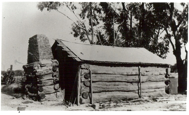
Photograph - BURNT GULLY PHOTOS, 1924
Burnt Gully - possibly near Woodvale. a. Black and white photo: men standing behind, alongside bagged grain. Steam farm engine on RH side. Written on rear of photo: threshing team at lunch engine Ruston Procter steam. 8 horse power, single cylinder, working pressure 75 lbs per square inch. 80 revs per minte. Fly wheel 6 feet in diameter. b. Pilcher's thresher on Robert Riley's farm, Burnt Gully. Bullock drivers Bill Pilcher, Paddy Mulcair. Bullock drawn threshing machine, large group of men standing alongside and to rear of machine. Two men standing on top of thresher. Steam traction engine on far left of photo. c. Pioneer log cabin Burnt Gully, the home of the Grafton family, demolished about 1930. Hut of slab construction, with corruated iron roof over timber slats. Chimney of logs and slabs topped with bricks on LH side of house. Steam farm machine in background on LH side.unknownagriculture, farm, grafton familyh, robert riley, bill pilcher, paddy mulcair, burnt gully. -
 Bendigo Historical Society Inc.
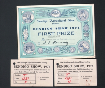
Document - FIRST PRIZE CERTIFICATE, 1974
Certificate and entry tickets: Certificate awarded to F. T. Kennedy for entry in Photography, for 'landscape or marine' Certificate is pale green, with darker green border. Certificate belongs to item 1175 a. Photo by F.T. Kennedy.document, certificate, f.t. kennedy, bendigo agricultural show -
 Bendigo Historical Society Inc.
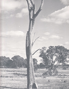
Photograph - AGRICULTURAL SCENE, 1960-70's
Black and white photo: Landscape view of farming land, with large dead tree in centre foreground. Sheep are grazing in paddocks, stand of eucalypts in background of photo. Picture was exhibited in Bendigo Agricultural Show, 1974. Photo is accompanied by First Prize Certificate, Bendigo Show 1974.F. T. Kennedyplace, landscape view, agricultural -
 Bendigo Historical Society Inc.
Book - PASTORAL SETTLEMENT IN NORTHERN VICTORIA - VOL 1. THE COLIBAN DISTRICT, 1979
Pastoral Settlement in Northern Victoria, volume 1, the Coliban District. 353 pages with illustrations, photographs and maps.J.O. Randellhistory, agriculture, northern victoria - coliban, farming, agriculture, pastoral settlement, stations, runs -
 Bendigo Historical Society Inc.
Book - THE PASTORAL PATTERSONS, 1977
The Pastoral Pattersons - 236 pages with illustrations and photographs and pull out maps. History of the Patterson family in pastoral life. Myles Patterson arrived in Hobart in 1822. First edition limited copies 775. Signed by J.O. Randell, copy number 325.J.O. Randellbiography, family, patterson, patterson, myles patterson, farming, agriculture -
 Bendigo Historical Society Inc.
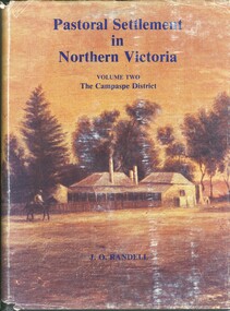
Book - PASTORAL SETTLEMENT IN NORTHERN VICTORIA VOLUME TWO CAMPASPE DISTRICT
Book: PASTORAL SETTLEMENT IN NORTHERN VICTORIA VOLUME TWO CAMPASPE DISTRICT - 602 pages with photos, illustrations, and pull out maps. History of stations and runs in the region.J.O. Randellhistory, agriculture, northern victoria - campaspe, farming, pastoral life, farming life, northern victoria. agriculture -
 Bendigo Historical Society Inc.
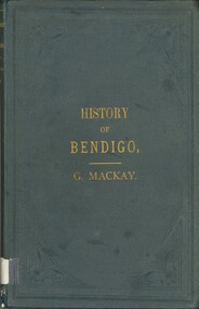
Book - HISTORY OF BENDIGO, 1891
History of Bendigo. Has a panorama included of Pall Mall Bendigo in 1891. General history of Bendigo from gold discovery to the present day, (1891). Mining development, Politics, and matters municipal. Other chapters contain information in relation to Water Supply, Journalism, Public Institutions, the Churches, Amusements, Agriculture, and Viticulture, and lastly Local Industries.George Mackaybendigo, history, city history, mining, politics, municipal, water supply, journalism, public institutions, churches, amusements, agriculture, viticulture, and local industries. -
 Bendigo Historical Society Inc.
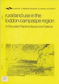
Book - RURAL LAND USE IN THE LODDON-CAMPASPE REGION, 1976
RURAL LAND USE IN THE LODDON-CAMPASPE REGION - a discussion paper on issues and options. 30 pages, with maps.Loddon-Campaspe regional planning authoritybook, rural, land use, loddon campaspe, rural, land use, agriculture -
 Bendigo Historical Society Inc.
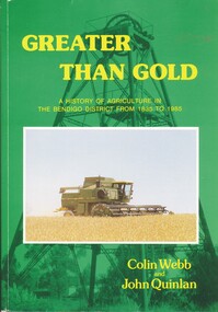
Book - GREATER THAN GOLD, 1985
Greater Than Gold. A History of Agriculture in The Bendigo District from 1835 to 1985. Includes photos of people, things and places.Colin Webb and John Quinlanbendigo, industry, agriculture. -
 Bendigo Historical Society Inc.
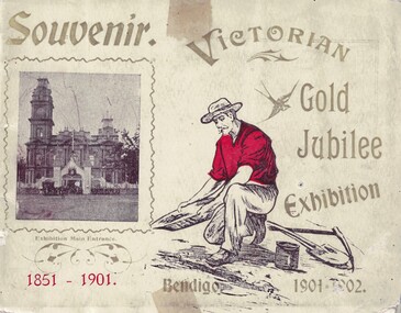
Souvenir - Views of Bendigo, 1902
The Victorian Gold Jubilee Exhibition, held at Bendigo from 13 November 1901 to 14 May 1902. The courts were numbered from one, or had titles like “Machinery”, “Agricultural”, “Naval & Military Court” and “Art”. The female visitors to the Exhibition were able to view exhibits deemed suitable for the fairer sex and located within their own “Women’s Court”. There were exhibits such as “Parasols & Umbrellas”, cotton and haberdashery from Manchester and Staffordshire, “Corsets & Embroideries” from Paris. The most valuable exhibits were mining machinery such as Taylor Horsfield’s £850 “Air Compressor & Rock Borer”. “Bohemian Glassware” brought down from Sydney was valued at £600. The profits from this Exhibition were used to fund the sculpture known as the Gold Monument, which still gazes along Pall Mall (from the McCrae Street end). The Exhibition’s Cash Book shows payments, which totalled £1160, were made to then up and coming sculptor C.D.Richardson. Recently a City of Greater Bendigo staff member used both these volumes to write a detailed report about this monument, for Heritage Victoria.Carol Holsworth Collection: Small book Souvenir, 29 pages plus cover; each page. has a photo of the exhibit. Exhibition was held on the site of the present Bendigo Library between Hargreaves St and Lyttleton Terrace. * 8662.1a Victorian Gold Jubilee Exhibition - Front Cover: Printed 'Souvenir', 'Bendigo 1901-1902'; a photo of the Entrance to the exhibition beside the Town Hall. * 8662.1b Victorian Gold Jubilee Exhibition - Inside Front Cover - Page 1 of 29. Portraits of Exhibition President S.H. Cowen esq.; and G.V. Allen esc., General Secretary. Photos by W.H. Robinson publisher. Printed by T. Cambridge, Market Square Bendigo. * 8662.1c Victorian Gold Jubilee Exhibition - Page 1 of 29 The Governor General at the Exhibition. Photo of the crowd, police, trooper and horse drawn vehicles. * 8662.1d Victorian Gold Jubilee Exhibition - Page 2 of 29 Procession Passing the Fountain, Pall Mall. The crowd and horse drawn vehicles. *8662.1e Victorian Gold Jubilee Exhibition - Page 3 of 29 James Martin and Co's Exhibit. James Martin & Co was an Australian engineering company which progressed from making agricultural equipment to making railway locomotives. * 8662.1f Victorian Gold Jubilee Exhibition - Page 4 of 29 Old Pioneers. Elderly gentlemen on foot and carriage - at the Bendigo Railway Station. * 8662.1g Victorian Gold Jubilee Exhibition - Page 5 of 29 Robert Harper and Company's Exhibit. From Trove - The Brisbane Courier 25 Aug 1891: One of the best known firms in the Southern hemisphere is Messrs. Robert Harper and Co , tea importers, coffee, rice, and spice merchants and manufacturers Then productions circle this continent, and every thrifty housewife is familiar with their Empire tens, their Star' brand of goods, then oatmeal, wheatmeal, and other breakfast table luxuries The headquarters of the firm are placed at Port Melbourne, and the manufactory there occupies over an acre of ground, while the mills at Sydney and Adelaide are as great in proportion It is eight cars since the firm opened business in this colony. The step was taken with much confidence, the principals the firm being quite attracted. * 8662.1h Victorian Gold Jubilee Exhibition - Page 6 of 29 The Electric Tram * 8662.1i Victorian Gold Jubilee Exhibition - Page 7 of 29 G. Weymouth Proprietary Ltd. The business of G. Weymouth & Co was founded in 1898 by George Andrew Philip Weymouth, who began operating from a small workshop on City Road, South Melbourne (opposite Princes Bridge). An early advertisement describes the firm's activities at this time as being 'makers of dynamos, (electric) motors, x-ray apparatus and electrical instruments, &c' together with 'repairs to every class of electrical work'. * 8662.1j Victorian Gold Jubilee Exhibition - Page 8 of 29 The Exhibition Fernery * 8662.1k Victorian Gold Jubilee Exhibition - Page 9 of 29 Cohn Bros'. Exhibit. In 1857 at the height of the gold rush, with people pouring into Central Victoria from all over the world, three brothers from Denmark – Moritz, Julius and Jacob Cohn – founded a small cordial factory in the booming town of Bendigo. They went on to build an empire and, through introducing lager, which is served cold, to the country, changed the drinking preferences of Australians. * 8662.1l Victorian Gold Jubilee Exhibition - Page 10 of 29 Ornamental Lake in the Exhibition Grounds * 8662.1m Victorian Gold Jubilee Exhibition - Page 11 of 29 Australian Explosives and Chemical Co.'s Exhibit. The Australian Explosives and Chemical Company began manufacturing explosives in Melbourne's outskirts (the area now known as Deer Park) in 1875. In 1897 the Company was purchased by Nobel, forming Nobel (Australasia) Ltd. * 8662.1n Victorian Gold Jubilee Exhibition - Page 12 of 29 Tasmanian Court * 8662.1o Victorian Gold Jubilee Exhibition - Page 13 of 29 N. Guthridge's Limited Exhibit. Guthridge sold a variety of mining supplies and equipment; also 'Rackarock' which was used to fill the mining drill holes before blasting. * 8662.1p Victorian Gold Jubilee Exhibition - Page 14 of 29 Navel and Military Court (LARGE File) * 8662.1q Victorian Gold Jubilee Exhibition - Page 15 of 29 Women's Court * 8662.1r Victorian Gold Jubilee Exhibition - Page 16 of 29 T. J. Connelly and Co's Exhibit. T.J. Connelly an American immigrant came to the Bendigo goldfields where he later established Connelly’s Tin Shop on the corner of High and Forest Streets 1853. Connelly was named after Thomas Jefferson the famous statesman who wrote much of the American Declaration of Independence in 1776 and became the third United States President. Connelly, along with other prominent citizens of the time established Bendigo’s first Fire Brigade, Mechanics Institute. * 8662.1s Victorian Gold Jubilee Exhibition - Page 17 of 29 The Potter's Wheel * 8662.1t Victorian Gold Jubilee Exhibition - Page 18 of 29 G. D. Guthrie and Co.'s Exhibit. In 1863 the Bendigo Pottery was set up by Guthrie. * 8662.1u Victorian Gold Jubilee Exhibition - Page 19 of 29 The Ladies' Committee * 8662.1v Victorian Gold Jubilee Exhibition - Page 20 of 29 J. Kitchen and Sons Exhibit. In Port Melbourne since the 1850s they made such products as Velvet Soap and Electrine Candles from the tallow and other animal fats from the nearby slaughter yards. In recent decades the company has become Kitchen & Lever then Unilever and most recently Unichema. * 8662.1w Victorian Gold Jubilee Exhibition - Page 21 1of 29 The Executive Committee * 8662.1x Victorian Gold Jubilee Exhibition - Page 22 of 29 Taylor Horsfield Exhibit. The most valuable exhibits were mining machinery such as Taylor Horsfield’s £850 “Air Compressor & Rock Borer” * 8662.1y Victorian Gold Jubilee Exhibition - Page 23 of 29 A Peep at the Education Department 8662.1z Victorian Gold Jubilee Exhibition - Page 24 of 29 John Danks and Co's Exhibit. John Danks & Son was a major manufacturing company in Melbourne, Victoria and Sydney, New South Wales. * 8662.1aa Victorian Gold Jubilee Exhibition - Page 25 of 29 Glance at the Agricultural Department's Court * 8662.1bb Victorian Gold Jubilee Exhibition - Page 26 of 29 T. York's Exhibit. Thomas York was an instrument repairer and brass instrument maker that resided in Melbourne in the late 19th to the early 20th century. While old newspaper advertisements suggested he repaired all instruments, it appears the focus of his business were military and brass band instruments. (BrassandWoodWind.com) * 8662.1cc Victorian Gold Jubilee Exhibition - Page 27 of 29 T. McPherson and Son's Exhibit. Possibly monumental masons. * 8662.1dd Victorian Gold Jubilee Exhibition - Page 28 of 29 T. Lewis and Whitty's Exhibit - Inside Back Cover. Lewis & Whitty were prominent boot blacking manufacturers as well as a number of other chemical products such as “Odourbane" disinfectant. * 8662.1ee Victorian Gold Jubilee Exhibition - Page 29 of 29 Singer Manufacturing Coy's Exhibithistory, bendigo, victorian gold jubilee exhibition bendigo, carol holsworth collection -
 Bendigo Historical Society Inc.
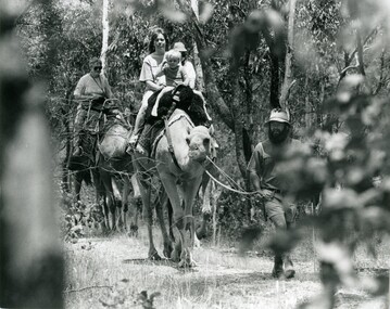
Photograph - SEDGWICK CAMEL FARM
Black and white photo of Paul Robinson leads a party of fours on a trek trough bush at Sedgwick camel farm.agriculture, farm, camel farm -
 Bendigo Historical Society Inc.
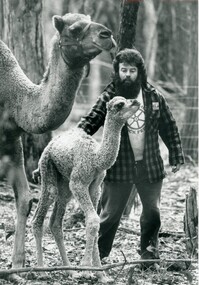
Photograph - SEDGWICK CAMEL FARM
Black and white photo of Paul Robinson with a camel calf and a camel at the Sedgwick camel farm.agriculture, farm, camel farm -
 Bendigo Historical Society Inc.
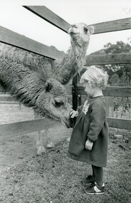
Photograph - SEDGWICK CAMEL FARM
Black and white photo of a young girl patting a camel with another camel looking on at Sedgwick camel farm.agriculture, farm, camel farm -
 Bendigo Historical Society Inc.
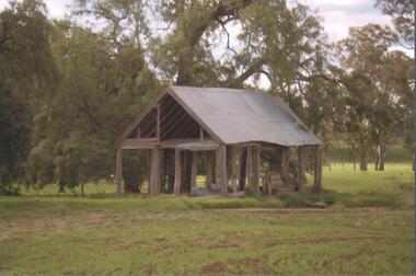
Photograph - BENDIGO HISTORICAL SOCIETY COLLECTION: KENNEDY'S OLD STABLE BUILDING , BARNADOWN
Colour photograph of Kennedy's old stables, Barnadown, situated near the Burke and Wills Memorial site. Shed has timber uprights and iron roof, no cladding on the walls. Large trees behind. Property is situated near the Campaspe River.agriculture, farm, kennedy's woolshed -
 Bendigo Historical Society Inc.
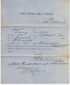
Document - CONNELLY, TATCHELL, DUNLOP COLLECTION: LEGAL PAPERS, 1886
Documents. Connelly, Tatchell & Dunlop - Legal Papers. 1 - 1886 - Letter from Jenkins & Barger, General Blacksmiths, Horse-Shoers & Agricultural Implement Makers, Leichardt and Bridgewater re McClean. 2 - 1886 - Letter from D Hughes re Adams & Maxwell?. 3 - 1886 - Letter from Crawford W H, 28;7 Clarence St, Sydney. 4 - 1886 - Post Office Telegraph from Portland re McKay. 5 - 1886 - Letter from The London Chartered Bank of Australia re Barwick J. 6 - 1886 - Letter from Bray R J, 19 Lily Street, Sandhurst re his cousin Bray Thomas, deceased. 7 - 1886 - Letter from Inglewood - Gooding. 8 - 1886 - Letter from Registrar of Titles re Gooding.cottage, miners, connelly, tatchell & dunlop, jenkins & barger, mcclean, hughes d, adams, maxwell, crawford w h, mckay, the london chartered bank o australia, barwick j, bray r j, bray thomas, gooding, register of titles -
 Bendigo Historical Society Inc.
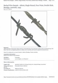
Document - ABBOTT COLLECTION: ABBOTT BARBED WIRE, 1943
Web page retrieved from the Museum of Victoria website, with a picture of Barbed wire sample - Abbott, Single Strand, Four Point, Double Kink, Bendigo , Australia, 1943Museum Victoriatopic, farming, barbed wire, agriculture, barbed wire, fencing, fencing wire, industrial design, innovations, h.a. abbott -
 Bendigo Historical Society Inc.
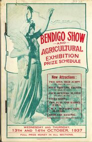
Book - BENDIGO SHOW AND AGRICULTURAL EXHIBITION PRIZE SCHEDULE, 1937
Bendigo Show and Agricultural Exhibition prize schedule 1937, 120 pages with black and white photographs and advertisements, printed by Cambridge Press.book, bendigo, bendigo organisations & businesses, bendigo-businesses-agriculture -
 Bendigo Historical Society Inc.
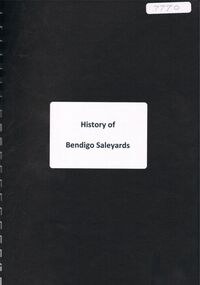
Document - ''HISTORY OF BENDIGO SALEYARDS''
''History of Bendigo Saleyards''. This document is comprised of a paper titled 'Going, Going, Gone'' and as a history of the saleyards, appears to have been written /authorized by Mr John Quinlan (Convenor, Historical Field Day Committee, Department of Agriculture) see covering letter from C C Campbell, City Engineer. Covers history from 1861; reference to abattoirs on site; railway spur; Country Roads Board; Wellsford Forest site; Marong site. Other part of document is a list of various dates with short description of activity for that year from 1861 to September 1984 - this list is by M (Malcolm) Styles of City Engineers Department. Reference to Bendigo East Bowling Club; Bendigo East Swimming Pool.Mr John Quinlanbendigo, business, bendigo saleyards, mr a.m. lloyd, bendigo east bowling club, bendigo east swimming pool. -
 Bendigo Historical Society Inc.
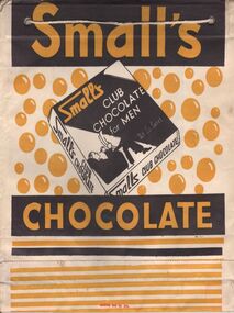
Ephemera - SHOWBAGS COLLECTION: SMALL'S CHOCOLATE SHOWBAG
Small's Chocolate Showbag. One side yellow, black and white writing, at the centre a chocolate box with a picture of a man sitting on a chair with a newspaper and the words small's club chocolate for men - Not so sweet. On the other side the same picture but the writing is in yellow, red and white.business, retail, advertising, business advertising usually found at agricultural shows and other promotional activities. -
 Bendigo Historical Society Inc.
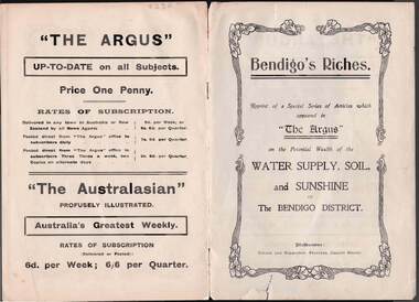
Document - BENDIGO'S RICHES, THE ARGUS PUBLICATION
Fifteen page cream coloured booklet published circa 1910 by 'The Argus' titled 'Bendigo's Riches', donated by Kevin Moulynox. Front cover shows 'Bendigo's Riches -reprint of a Special series of articles which appeared in 'The Argus 'on the potential wealth of water supply, soil, and sunshine of the Bendigo district . Comment is made about the potential of Tomato cultivationbendigo, history, agriculture