Showing 231 items matching " bendigo agriculture "
-
 Bendigo Historical Society Inc.
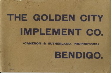
Book - ERROL BOVAIRD COLLECTION: THE GOLDEN CITY IMPLEMENT CO
Small book with brown cover and dark blue printing. Printed by Cambridge Press, Bendigo. Contains photos or drawings of scarifiers, points, tynes, disc cultivators, duplicate parts for disc cultivator, spike roller, drag harrows, drag harrows with harrow cart, mould board ploughs, circular coulters, earth scoops, pulley chain yokes, swings and pipe bars, leveller and smoother, delver and crowder, buck scraper, land louvre grader, stock troughs and windmill parts. Description and sizes of are included. Windmill parts and disc cultivator parts have catalogue numbers.john bovaird collection - the golden city implement co, cameron & sutherland, agricultural implements, cambridge press -
 Bendigo Historical Society Inc.
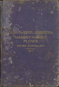
Book - ERROL BOVAIRD COLLECTION: AUSTRALASIAN UNIVERSAL MASSEY HARRIS PLOWS EXTRA PARTS LIST 1923
... Bendigo Historical Society Inc. Bendigo Historical Society ...Book with dark blue cloth cover, gold printing on the front and pinkish red edges to the pages. Australasian Edition, Universal List of Extra Parts for Repairs for Ploughs, Scufflers, Land Packers, Rollers, Barrows, &c. Published in 1923. Massey-Harris Co., Limited Toronto, Canada, and Melbourne, Australia. Book has illustrations of the different plough, etc. and description of part. There are plates with drawings of parts and numbers and illustrations of bolts, cotters and nuts, etc.rural industry, agriculture - cultivation, massey-harris plows, john bovaird collection - australasian universal massey-harris plows extra parts list 1923, massey-harris co limited -
 Bendigo Historical Society Inc.
Map - CAMPBELL COLLECTION: BENDIGO AND DISTRICT MAPS, 11-4-29
... Bendigo agricultural lands W.J.Galbraith Map. Huntly, Parishes ...Map. Huntly, Parishes of Huntly Nerring and Neilborough. Scale 20 chains to 1 inch. Total area 4738 acres. Eaglehawk. Prepared in W.J.B. from A. and C.L. Plans by W.J.Galbraith 11-4-29. (number 396 in map cupboard 1)W.J.Galbraithmap, bendigo, agricultural lands -
Bendigo Historical Society Inc.
Map - CAMPBELL COLLECTION: BENDIGO AND DISTRICT MAPS, 14-6-29
... Bendigo agricultural lands W.J.Galbraith Map. Terricks, Parish ...Map. Terricks, Parish of Terrick Terrick West, scale 20 chains to 1 inch, total area 6318 acres, prepared in W.P.B. from Assessment and Parish Plans by W.J.G. 14-6-29. (number 388 in map cupboard 1)W.J.Galbraithmap, bendigo, agricultural lands -
Bendigo Historical Society Inc.
Map - CAMPBELL COLLECTION: BENDIGO AND DISTRICT MAPS, 18-6 29
... Bendigo agricultural lands H.A.Darby Map. Longlea, Parishes ...Map. Longlea, Parishes of Axedale and Eppalock, scale 20 chains to 1 inch, total area 2372 acres. Prepared from Assessment Plan and Parish Plan by H.A. Darby18-6-29., Wondong, Heathcote and Sandhurst line (Railway). (number 386 in map cupboard 1)H.A.Darbymap, bendigo, agricultural lands -
Bendigo Historical Society Inc.
Map - CAMPBELL COLLECTION: BENDIGO AND DISTRICT MAPS, 23-4-29
... Bendigo agricultural lands G.W.Latimer Map. Whirrakee, Parish ...Map. Whirrakee, Parish of Whirrakee, Total area 4419 acres, scale 20 chains to 1 inch. Unused water race in centre of map. Eucalypt Oil Distillery, bottom of map. Prepared in W.P.B. from Assessor's Plan and Parish Plan. G.W.Latimer 23-4-29. (number 385 in map cupboard 1)G.W.Latimermap, bendigo, agricultural lands -
Bendigo Historical Society Inc.
Map - CAMPBELL COLLECTION: BENDIGO AND DISTRICT MAPS, 9-4-29
... Bendigo agricultural lands W.J.Galbraith Map. Campaspe, Parish ...Map. Campaspe, Parish of Kimbolton, Scale 20 chains to 1 inch. Total area 4117 acres, Campaspe River, Prepared in W.P.B. by W.J.Galbraith from Parish and Assessment Plans. (number 384 in map cupboard 1)W.J.Galbraithmap, bendigo, agricultural lands -
Bendigo Historical Society Inc.
Map - CAMPBELL COLLECTION: BENDIGO AND DISTRICT MAPS, 12-2-29
... Bendigo agricultural lands W.J.Galbraith Map. Axedale, Parish ...Map. Axedale, Parish of Ellesmere and Axedale, Total area 4156 acres, Prepared in W.P.B. from A. and P. Plans by W.J. Galbraith 12-2-29. (number 383 in map cupboard 1)W.J.Galbraithmap, bendigo, agricultural lands -
Bendigo Historical Society Inc.
Map - CAMPBELL COLLECTION: BENDIGO AND DISTRICT MAPS, 8-2-29
... Bendigo agricultural lands .W.J.Galbraith Map. Bagshot, Parishes ...Map. Bagshot, Parishes of Wellsford, Ellesmere, and Bagshot. Huntly 4 miles, Fosterville 3 miles. Total area 5037 acres, Prepared in W.P.B. from A.C.L and D.B. Plans, by W.J.Galbraith 8-2-29. (number 382 in map cupboard 1).W.J.Galbraithmap, bendigo, agricultural lands -
Bendigo Historical Society Inc.
Map - CAMPBELL COLLECTION: BENDIGO AND DISTRICT MAPS, 30-1-29
... Bendigo agricultural lands W.J.Galbraith Map. Ellesmere, Parish ...Map. Ellesmere, Parish of Ellesmere, scale 20 chains to 1 inch. Total area 3926 acres. Prepared in W.P.B. from A. and P. Plans, by W.J. Galbraith, 30-1-29, to Bendigo along Fosterville. (number 381 in map cupboard 1)W.J.Galbraithmap, bendigo, agricultural lands -
Bendigo Historical Society Inc.
Map - CAMPBELL COLLECTION: BENDIGO AND DISTRICT MAPS
... Bendigo agricultural lands Map. Ascot, Parishes of Huntly ...Map. Ascot, Parishes of Huntly, Sandhurst and Wellsford. Scale 20 chains to 1 inch. Total area 2818 acres. To Bendigo 4 1/2 miles, to Epsom 3/4 mile, Huntly 3/4 mile. Prepared in W.P.B. from Assessment Plans and Parish Plans. (number 380 in map cupboard 1)map, bendigo, agricultural lands -
Bendigo Historical Society Inc.
Map - CAMPBELL COLLECTION: BENDIGO AND DISTRICT MAPS, 15-2-29
... Bendigo agricultural lands W.J.Galbraith Map. Nerring, Parish ...Map. Nerring, Parish of Nerring, scale 20 chains to 1 inch. Prepared in W.P.B. from A. and P. Plans by W.J. Galbraith. 15-2-29. (number 379 in map cupboard 1)W.J.Galbraithmap, bendigo, agricultural lands -
Bendigo Historical Society Inc.
Map - CAMPBELL COLLECTION: BENDIGO & DISTRICT MAPS, 14-6-29
... Bendigo agricultural lands H.A.Darby Map. Eppalock, Sedgwick ...Map. Eppalock, Sedgwick and Strathfieldsaye. Scale 20 chains to 1 inch. Total area 3972 acres. Prepared in W.P.B. from Assessment Plan and Parish Plans. H.A. Darby. (number 378 in map cupboard 1)H.A.Darbymap, bendigo, agricultural lands -
Bendigo Historical Society Inc.
Map - CAMPBELL COLLECTION: BENDIGO & DISTRICT MAPS, 16-5-29
... Bendigo agricultural lands W.J.Galbraith Map. Egerton, Parishes ...Map. Egerton, Parishes of Egerton and Whirrakee, scale 20 chains to 1 inch. Total area 5401 acres. Prepared in W.P.B. from A. and C.L. Plans by W.J. Galbraith (number 376 in map cupboard 1)W.J.Galbraithmap, bendigo, agricultural lands -
Bendigo Historical Society Inc.
Map - CAMPBELL COLLECTION: BENDIGO & DISTRICT MAPS
... Bendigo agricultural lands Map. Lockwood, Parishes of Lockwood ...Map. Lockwood, Parishes of Lockwood and Shelbourne. Scale 20 chains to 1 inch.Total area 4405 acres. Bullock Creek to the right, Spring Creek at Centre. Newbridge is 11 miles N E, To Marong, Bendigo Lockwood roads are on the left. (number 375 in map cupboard 1)map, bendigo, agricultural lands -
Bendigo Historical Society Inc.
Map - CAMPBELL COLLECTION: BENDIGO & DISTRICT MAPS, 5-4-28
... Bendigo agricultural lands W.J.Galbraith Map. Sedgwick, Parishes ...Map. Sedgwick, Parishes of Strathfieldsaye, Lyell and Sedgwick. Scale 20 chains to 1 inch.Total area 5372 acres. Prepared in W.P.B. from C.l. and A. Plans by W.J. Galbraith. (number 374 in map cupboard 1)W.J.Galbraithmap, bendigo, agricultural lands -
Bendigo Historical Society Inc.
Map - CAMPBELL COLLECTION: BENDIGO AND DISTRICT MAPS
... Bendigo agricultural lands Map. Sedgwick. Continuation of 10104.13 ...Map. Sedgwick. Continuation of 10104.13. (number 360 in map cupboard 1)map, bendigo, agricultural lands -
Bendigo Historical Society Inc.
Map - CAMPBELL COLLECTION: BENDIGO AND DISTRICT MAPS
... Bendigo agricultural lands Map. Sedgwick. Parishes ...Map. Sedgwick. Parishes of Strathfieldsaye, Lyell and Sedgwick. Scale 20 chains to 1 inch. (number 359 in map cupboard 1)map, bendigo, agricultural lands -
Bendigo Historical Society Inc.
Map - CAMPBELL COLLECTION: BENDIGO AND DISTRICT MAPS
... Bendigo agricultural lands H.A.Darby Map. Eppalock, Sedgwick ...Map. Eppalock, Sedgwick and Strathfieldsaye, scale 20 chains to 1 inch. Road to Bendigo 13 1/2 miles at top right of map, Longlea Railway Station 5 1/2 miles, Bendigo 11 miles, Strathfieldsaye 5 miles on left of map. Total area 3972 acres. Prepared in W.P.B. from Assessment Plan and Parish Plans. H.A. Darby 14-6-29.H.A.Darbymap, bendigo, agricultural lands -
Bendigo Historical Society Inc.
Map - CAMPBELL COLLECTION: BENDIGO AND DISTRICT MAPS
... Bendigo agricultural lands Map. Ellesmere, Parish of Ellesmere ...Map. Ellesmere, Parish of Ellesmere. Scale 20 chains to 1 inch. Total area 3926 acres. Prepared in W.P.B. from A and P plans. (number 354 in map cupboard 1)map, bendigo, agricultural lands -
Bendigo Historical Society Inc.
Map - CAMPBELL COLLECTION: BENDIGO AND DISTRICT MAPS, 8-2-29
... Bendigo agricultural lands W.J.Galbraith Map. Bagshot, Parishes ...Map. Bagshot, Parishes of Wellsford, Ellesmere and Bagshot. Scale 20 chains to 1 inch. Total area 5037 acres. Prepared in W.P.B. from A.C.l. and D.B. Plans, W.J. Galbraith, 8-2-29 (number 353 in map cupboard 1)W.J.Galbraithmap, bendigo, agricultural lands -
Bendigo Historical Society Inc.
Map - CAMPBELL COLLECTION: BENDIGO AND DISTRICT MAPS, 12-2-29
... Bendigo agricultural lands W.J.Galbraith Map. Axedale, Parishes ...Map. Axedale, Parishes of Ellesmere and Axedale. Scale 20 chains to 1 inch. To the west is Wellsford. Total area 4156 acres. Prepared in W.P.B. from A and P plans by W.J. Galbraith 12-2-29. (number 352 in map cupboard 1)W.J.Galbraithmap, bendigo, agricultural lands -
Bendigo Historical Society Inc.
Map - CAMPBELL COLLECTION: BENDIGO AND DISTRICT MAPS
... Bendigo agricultural lands Map. Lyell, Parishes of Sedgwick ...Map. Lyell, Parishes of Sedgwick, Eppalock and Lyell. Scale 20 chains to 1 inch. (number 348 in map cupboard 1)map, bendigo, agricultural lands -
 Bendigo Historical Society Inc.
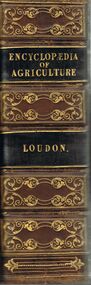
Book - AN ENCYCLOPAEDIA OF AGRICULTURE
... Bendigo Historical Society Inc. Bendigo Historical Society ...A hard covered copy of 'Encyclopaedia of Agriculture.' Compiled by J. C. Loudon. 4th edition. London. Longman, Orme, Brown, Green and Longmans. Pasternoster-Raw, 1839. 1378 p. (ill.) Various items have been pasted in on the inside page.J.C. Loudonbooks, technical, agriculture, books, agriculture, reference, encyclopaedias, horticulture, animals, farming -
 Bendigo Historical Society Inc.
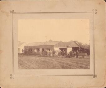
Photograph - GENERAL SMITH & AGRICULTURAL IMPLEMENT MAKER
Sepia photograph mounted on fawn board. Vertical board building and skillion. Two gable roof - open end under one gable. Large double doors (painted) under other gable. Small doors and windows with lift up shutters along side. Vehicles, wheels and 8 men in front of building. Small painted weatherboard building to L. Sign on front of building. Inscriptions: in image - 'Watkin Walker? & Treacy General Smith and Agricultural Implement Maker'.buildings, commercial -
 Bendigo Historical Society Inc.
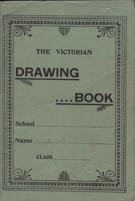
Document - BUSH COLLECTION: AGRICULTURAL SOCIETY ART ENTRY, 1911
Entry into Maffra Agricultural Society (Show) - Class Q Art Section 15 No. 3. A 'Victorian Drawing Book' entered by Merle Bush ( M. I.?. B in pencil on cover) - 12 pages of school drawing. Under 16 years. Agricultural Society entry card is inside front cover.person, individual, bush collection - personal -
 Bendigo Historical Society Inc.
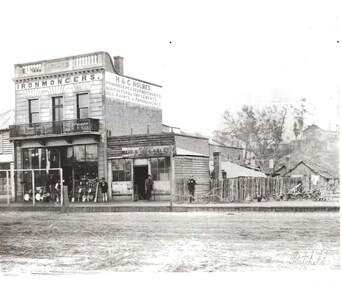
Photograph - H & C. HOLMES: IRONMONGERS, 1860's
Black and white photo, reprint of Batchelder photo. Two storey brick building ' Holmes' cast in concrete parapet. Iron lace trim on balcony. Holmes Ironmonger, Agricultural Implements, oils, paints and paper hangings painted on side. Building in McCrae Sreet. Small weatherboard building with ' Bendigo Rifle Gallery - W. Callaghan. Brooms, pans, pans in front of shop boardwalk, Ploughs to right of photo. 4 male figures present.Batchelderbuildings, commercial, h & c. holmes, ironmongers -
 Bendigo Historical Society Inc.
Photograph - BURNT GULLY PHOTOS, 1924
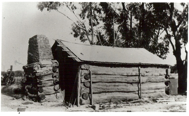
... Bendigo Historical Society Inc. Bendigo Historical Society ...Burnt Gully - possibly near Woodvale. a. Black and white photo: men standing behind, alongside bagged grain. Steam farm engine on RH side. Written on rear of photo: threshing team at lunch engine Ruston Procter steam. 8 horse power, single cylinder, working pressure 75 lbs per square inch. 80 revs per minte. Fly wheel 6 feet in diameter. b. Pilcher's thresher on Robert Riley's farm, Burnt Gully. Bullock drivers Bill Pilcher, Paddy Mulcair. Bullock drawn threshing machine, large group of men standing alongside and to rear of machine. Two men standing on top of thresher. Steam traction engine on far left of photo. c. Pioneer log cabin Burnt Gully, the home of the Grafton family, demolished about 1930. Hut of slab construction, with corruated iron roof over timber slats. Chimney of logs and slabs topped with bricks on LH side of house. Steam farm machine in background on LH side.unknownagriculture, farm, grafton familyh, robert riley, bill pilcher, paddy mulcair, burnt gully. -
 Bendigo Historical Society Inc.
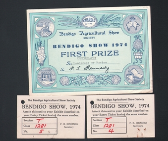
Document - FIRST PRIZE CERTIFICATE, 1974
... DOCUMENT Certificate f.t. kennedy Bendigo Agricultural Show ...Certificate and entry tickets: Certificate awarded to F. T. Kennedy for entry in Photography, for 'landscape or marine' Certificate is pale green, with darker green border. Certificate belongs to item 1175 a. Photo by F.T. Kennedy.document, certificate, f.t. kennedy, bendigo agricultural show -
 Bendigo Historical Society Inc.
Book - PASTORAL SETTLEMENT IN NORTHERN VICTORIA - VOL 1. THE COLIBAN DISTRICT, 1979
... Bendigo Historical Society Inc. Bendigo Historical Society ...Pastoral Settlement in Northern Victoria, volume 1, the Coliban District. 353 pages with illustrations, photographs and maps.J.O. Randellhistory, agriculture, northern victoria - coliban, farming, agriculture, pastoral settlement, stations, runs