Showing 706 items matching " burwood rd"
-
 Deaf Children Australia
Book, Register of Pupils
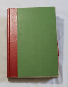
... , admitted to Princess Elizabeth Kindergarten for the Deaf (Elgar Rd..., admitted to Princess Elizabeth Kindergarten for the Deaf (Elgar Rd ...As children were admitted to Victorian Deaf and Dumb Institution, The Victorian School for Deaf Children and Deaf Children Australia, their details were recorded and they were given a registration number. Information included Medical Information.The Registers document where children came from, their family details and medical information, all relating to the time they were admitted and reflect the society of the time.Light green fabric with red tape over spine bound book containing specially printed pages with handwritten entries and an alphabetical index notebook attached to back cover. Contains register of pupils of Victorian School for Deaf Children, from 1970 to 1973, admitted to Princess Elizabeth Kindergarten for the Deaf (Elgar Rd, Burwood). Each entry is a full open two pages. The alphabetical index notes their Admission (?) number from 1993 to 2181Spine: "REGISTER OF PUPILS" in gold lettering "1993-2181/YEARS 1970 - 1973" handwritten in inkdeaf children australia, deaf education, register of pupils -
 Deaf Children Australia
Book, Register of Pupils
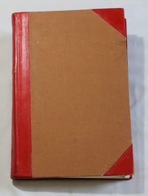
... to Princess Elizabeth Kindergarten for the Deaf (Elgar Rd, Burwood... Kindergarten for the Deaf (Elgar Rd, Burwood). Each entry is a full ...As children were admitted to Victorian Deaf and Dumb Institution, The Victorian School for Deaf Children and Deaf Children Australia, their details were recorded and they were given a registration number. Information included Medical Information.The Registers document where children came from, their family details and medical information, all relating to the time they were admitted and reflect the society of the time.Brown fabric with red leather over spine and on front and back cover corners, bound book containing specially printed pages with handwritten entries and an alphabetical index notebook attached toinside back cover. Contains register of pupils of Victorian School for Deaf Children, from 1973 to 1978, admitted to Princess Elizabeth Kindergarten for the Deaf (Elgar Rd, Burwood). Each entry is a full open two pages. The alphabetical index notes their Admission (?) number from 2182 to 2451Spine: "2182/to/2451" "1973/to/1977" handwritten in ink. Stamping on edge of red leather.deaf children australia, deaf education, register of pupils -
 Melbourne Tram Museum
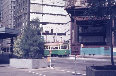
Album - Robert Thomson Slide Collection, "Melbourne 1970 - 1979"
... St Burwood Rd Jct, tram 9 - "Special" RT280 Riversdale Rd... St Burwood Rd Jct, tram 9 - "Special" RT280 Riversdale Rd ...Photo - see pdf file for further information. Number Brief Description RT264 Elizabeth St, at Bourke St, with the construction of the State Savings Bank building (State Bank Galleria) underway. Bourke St Mall also under construction, Note tram warning Sign, tram 1065 - "West Maribyrnong" - route 57 RT265 St Kilda Road, tram 778 - "City" -route 59 RT266 St Kilda Road, tram 569 - "East Malvern Darling Road" -route 3 & tram 819 - "Glen Iris" - route 6 RT267 Swanston St, tram 538 - "City" - route 2A RT268 St Kilda Junction, tram 924 - "City" - route 5 RT269 St Kilda jct, tram 280 - "St Kilda Beach" - route 15 RT270 St Kilda Road, tram 507 - "City" - route 72 RT271 Nicholson St Gertrude St - tram7 - "East Preston Tyler St" - route 88 RT272 West Coburg, tram 778 - "Domain Rd" - route 55 RT273 Wests Road, tram 750 - "Moonee Ponds" - route 22 RT274 St Kilda Rd, tram 8 - "Special" RT275 Nicholson St Victoria Pde, tram 10W - "Special" RT276 L Class Queens way, "City" - route 54 RT277 Bourke St at Spring St, tram 998 - "East Coburg" - route 88 RT278 Nicholson St MMTB Bus, bus 562 - "Garden City via Port Melb" - route 2 RT279 Church St Burwood Rd Jct, tram 9 - "Special" RT280 Riversdale Rd at Camberwell Depot - "Burwood" - route 74 RT281 Balaclava Junction - tram 819 - "Kew Cotham Rd" - route 69 RT282 East Brunswick Terminus, tram 4 - "City Spencer St" - route 96 RT283 Peel St - tram 927 - "Special" RT284 East Brighton Terminus - tram 563 & tram 926 - "City" - route 64 RT285 Dandenong Rd Hawthorn Rd, tram 346 - route 64 RT286 Bourke St at Spring St, tram 34 - "North Fitzroy Park St" - route 97 RT287 Route 69 Terminus St Kilda - tram 369 - "Kew Cotham rd" - route 69 RT288 Route 78 Terminus St Kilda, tram 498 - "North Richmond" - route 78 RT289 Track relay, Fitzroy St, St Kilda RT290 Fitzroy St, St Kilda Demonstrates the work of Robert Thomson in photography, collection and/or production of slidesAssembled album in a black presentation folder of 27 colour slides, collected or produced by Robert Thomson. All photographs have been scanned and placed on the Museum's G drive. A list of all photographs with details has been compiled. melbourne, tramways, trams, track construction, elizabeth st -
 Eltham District Historical Society Inc
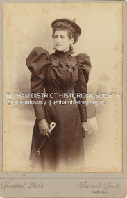
Photograph - Cabinet Photograph, Rowland Chubb, Possibly Isabella Roberts, c.1900
Isabella Roberts, also known as Bella married Albert Key in 1902 Cabinet Photo Rowland Chubb Photographer, Burwood Road, Auburn Operated from Burwood Road between 1898-1900Inscribed on back in pencil ? Bella Keybella key, isabella key (nee roberts), isabella roberts, rowland chubb photographer burwood road auburn, pam thoonen (nee ingram) collection -
 Eltham District Historical Society Inc
Folder, City of Whitehorse, 2001
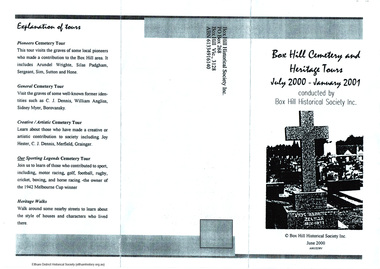
Collection of brochures relating to Box Hill, including Box Hill Artists' Camp , Box Hill cemetery (2001), Box Hill Historical Society and Burwood Primary School (1989).5 Pages HG Booklet 48harry gilham collection, burwood, box hill -
 Eltham District Historical Society Inc
Photograph, George Coop, Elgin Street railway overpass, Hawthorn, c.1962, 1962
Looking southwest towards the Burwood Road overpass on the Camberwell line. GC took this photograph as he liked the laciness of the bridge supports. It is GC's assumption that shortly after the Granville disaster in NSW (18 January 1977) where a train derailment wiped out the bridge supports causing the bridge to collapse and crush the train, that bridges of this kind were replaced to have a single arch bridge structure and that the opportunity was taken when the third line went out the Camberwell, Box Hill, Lilydale lines. There are now three lines there. Back then there used to be the old line coming from Hawthorn to Kew across Barkers Road behind Xavier College and into what is now the VicRoads building in the heart of Kew and a single carriage train like the shuttle service between Eltham and Hurstbridge operated on this line.Digital TIFF file Scan of 35mm Ilford FP3 black and white transparency458m, burwood road, camberwell line, elgin road, hawthorn, lilydale line, overpass, red rattler, tait train, -
 Eltham District Historical Society Inc
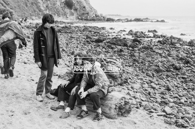
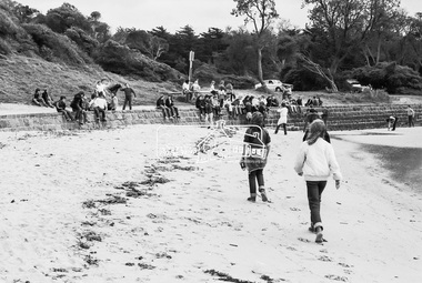
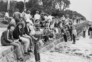
Photograph, George Coop, Sunnyside Beach, Mount Eliza, c.August 1983, 1983
Possibly an excursion or school camp for Year 8 or 9 students from Nunawading High School to the seaside at Mount Eliza. Nunawading High School opened on Canterbury Road (near Mahoneys Road) in 1955. Enrolments grew rapidly and by 1969 there were over 1,100 students, making it one of the largest schools in the state. In 1989 it was merged with Burwood Heights High and Blackburn South High to become a junior campus of Forest Hills Secondary College. However, the junior campuses were closed in 1997, and the former Nunawading High was bulldozed to make way for a housing estate. "Lost Schools of the 1990s", Learning from the Past, http://learningfromthepast.com.au/lost-schools-of-the-1990s/ George Coop was a teacher of art, craft, wood working and graphics at Nunawading High School until it merged into Forest Hills Secondary College at which point he retired.Digital TIFF file Scan of 35mm Kodak Safety 5062 black and white transparencymount eliza, nunawading high school, sunnyside beach -
 Eltham District Historical Society Inc
Photograph, George Coop, Sunnyside Beach, Mount Eliza, c.August 1983, 1983
Possibly an excursion or school camp for Year 8 or 9 students from Nunawading High School to the seaside at Mount Eliza Nunawading High School opened on Canterbury Road (near Mahoneys Road) in 1955. Enrolments grew rapidly and by 1969 there were over 1,100 students, making it one of the largest schools in the state. In 1989 it was merged with Burwood Heights High and Blackburn South High to become a junior campus of Forest Hills Secondary College. However, the junior campuses were closed in 1997, and the former Nunawading High was bulldozed to make way for a housing estate. "Lost Schools of the 1990s", Learning from the Past, http://learningfromthepast.com.au/lost-schools-of-the-1990s/ George Coop was a teacher of art, craft, wood working and graphics at Nunawading High School until it merged into Forest Hills Secondary College at which point he retired.Digital TIFF file Scan of 35mm Kodak Safety 5062 black and white transparencymount eliza, nunawading high school, sunnyside beach -
 Eltham District Historical Society Inc
Photograph, George Coop, Sunnyside Beach, Mount Eliza, c.August 1983, 1983
Possibly an excursion or school camp for Year 8 or 9 students from Nunawading High School to the seaside at Mount Eliza Nunawading High School opened on Canterbury Road (near Mahoneys Road) in 1955. Enrolments grew rapidly and by 1969 there were over 1,100 students, making it one of the largest schools in the state. In 1989 it was merged with Burwood Heights High and Blackburn South High to become a junior campus of Forest Hills Secondary College. However, the junior campuses were closed in 1997, and the former Nunawading High was bulldozed to make way for a housing estate. "Lost Schools of the 1990s", Learning from the Past, http://learningfromthepast.com.au/lost-schools-of-the-1990s/ George Coop was a teacher of art, craft, wood working and graphics at Nunawading High School until it merged into Forest Hills Secondary College at which point he retired.Digital TIFF file Scan of 35mm Kodak Safety 5062 black and white transparencymount eliza, nunawading high school -
 Eltham District Historical Society Inc
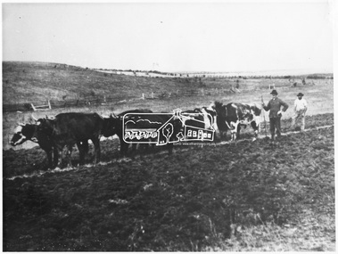
Photograph, Bullock Team on Ellis's Farm, Kangaroo Ground
Source: Mrs. F.B. Nansen, 8 Roslyn Street, BurwoodThis photo forms part of a collection of photographs gathered by the Shire of Eltham for their centenary project book,"Pioneers and Painters: 100 years of the Shire of Eltham" by Alan Marshall (1971). The collection of over 500 images is held in partnership between Eltham District Historical Society and Yarra Plenty Regional Library (Eltham Library) and is now formally known as the 'The Shire of Eltham Pioneers Photograph Collection.' It is significant in being the first community sourced collection representing the places and people of the Shire's first one hundred years.Digital imagesepp, shire of eltham pioneers photograph collection, kangaroo ground, ellis farm, bullock team -
 Eltham District Historical Society Inc
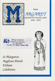
Book, Jenny Heath, Saint Margaret, Queen of Scotland; a history of Saint Margaret and Saint Margaret's Anglican Church, Eltham written and edited by Jenny Heath, 1994c
Includes information of Saint Margaret, Early days of Saint Margaret's Eltham, The Years between, kneelers, and brief descriptions of other churches with Saint Margaret connections including: Saint Margaret's Anglican Church Mildura, Saint Margaret's Anglican Church Caulfield, Burwood Presbyterian Church, Saint Margaret's Catholic Church and School Maribyrnong, Saint Margaret's Primary School and Catholic Church Keon Park and Saint Margaret's Catholic Parish East Geelong.Paperbackchurches, st margarets anglican church, st margarets church, eltham, st margaret -
 Eltham District Historical Society Inc
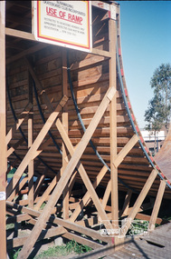
Photograph, Nunawading Skateboard Club ramp, c.1985, 1985c
Now the Vermont South Skateboard Ramp, cnr Burwood Highway and Morack Road.Roll of 35mm colour negative film, 2 stripsFuji 100nunawading skateboard club, skate park, vermont south skateboard ramp -
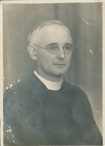 Uniting Church Archives - Synod of Victoria
Photograph
James Douglas Northey (1890 - 1975) was born in Adelaide. He attended Adelaide University and Parkin College. Ordained in 1916 at Kensington Gardens, S.A. Appointed: Luhrs Rd. Evandale S.A. 1917 - 1921, Victor Harbor 1921 - 1929, Canterbury Vic. 1929 - 1939, Principal of the Congregational College of Victoria 1940 - 1960. Pastoral oversight Burwood 1945 - 1951, East Preston 1952 - 1960, Northcote 1958, South St. Kilda 1962 - 1967. B & W head and shoulders studio portrait of the Rev. J.D. Northeyjames douglas northey, principal congregational college of victoria -
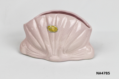 Whitehorse Historical Society Inc.
Decorative object - vase
... in 1936 at 109 Highbury Rd. Burwood. In1962-1966 it was located ...Lane's pottery was established in Burwood in 1936 at 109 Highbury Rd. Burwood. In1962-1966 it was located at327 Warrigal Rd. Burwood. The company was known as Lane, Kemp, Willis Potteries p/l, but was trading under Lanes Potteries in 1940. The company produced household pottery including lamp bases and artware vases.Pink shell shaped vase. Yellow and silver paper sticker on front. 213 on base of vase.Lane Potteries Burwood Victoria. Sticker 213ornaments, ceramics -
 Whitehorse Historical Society Inc.
Document, Horticultural Heritage Advice, 1/11/2002 12:00:00 AM
A list of significant trees.A list of significant trees at 5 Longland Rd, Heatherdale, 449 Springvale Road, Forest Hill, 129 Mount Pleasant Road, Forest Hill and 347 Blackburn Road, Burwood East including aerial photographs by Francine Gilfedder & Associates.A list of significant trees. heritage studies, horticulture, longland road, heatherdale no. 5, springvale road, forest hill no. 449, mount pleasant road, forest hill no. 129, blackburn road, burwood east no 347, gilfedder francine -
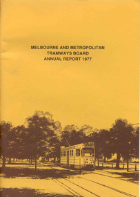 Ballarat Tramway Museum
Document - Report, Melbourne and Metropolitan Tramways Board (MMTB), MMTB Annual Reports 1977 to 1979, 1977 to 1979
Three copies of the Annual report of the MMTB for the years end 1977 to 1979. 3952.1 - "MMTB Annual Report 1977", brown card cover with a drawing of Z24 on the front cover, 24 pages, white paper, giving details of the MMTB Board, Officers, Introduction, Financial, Engineering, Industrial, Balance sheet, Summary of Income and Expenditure, Schedule of Debentures and Inscribed stock, auditors report, Schedule of tram and bus routes, and record of annual traffic receipts, passengers etc.. Photos include Z's in Bourke ST, after a heavy storm, new Volvo bus, display/advertising tram, Dandenong Rd, Route map board and Cathy Pacific advertisement. Printed by McCarron Bird. 3952.2 - "MMTB Annual Report 1978", gloss cover with a photo of Z18 in Wellington Parade on the front cover, 24 pages, white paper, giving details of the MMTB Board, Officers, Introduction, Financial, Engineering, Industrial, historical highlights, Balance sheet, Summary of Income and Expenditure, Schedule of Debentures and Inscribed stock, auditors report, Service Statistics, Schedule of tram and bus routes, and on inside back cover, route map. On back cover is a photo of Z20 in Wellington Parade. Photos include bus lane on Eastern Freeway, construction of Burwood Extension, first tram to Warragul Road, opening of Burwood tramway (1916), Volvo bus Bell St, upgraded computer installation, Volvo bus chassis, Z class bogie. Printed by McCarron Bird. 3952.3 - "MMTB Annual Report 1978-79", gloss card cover with a photo of Z 116 on the front cover, 24 pages, white paper, giving details of the MMTB Board, Officers, Introduction, Financial, Engineering, Industrial, historical highlights, Balance sheet, Summary of Income and Expenditure, Schedule of Debentures and Inscribed stock, auditors report, Service Statistics, Schedule of tram and bus routes, and on inside back cover, route map. On back cover is a photo of Z73, Nicholson St, Fitzroy. Photos include first tram on Burwood Extension, Volvo bus Westgate freeway, K. J. Brennan, map of Bundoora extension, Box Hill tram, V214, vintage trams day 1979, MAN Bus, Swanston St at dusk and montage of painted W2's. Printed by McCarron Bird.trams, tramways, mmtb, melbourne, annual reports, operations, trackwork -
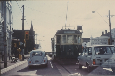 Ballarat Tramway Museum
Photograph - Colour Print, Clive Gibson, 1960's
Yields information about a Melbourne tramcar that was to be later collected by the Museum, when it was operating in Melbourne.Colour print of MMTB W3 661 in Glenferrie Road, at intersection with Burwood Road, Hawthorn 1960's? Photo Clive Gibson. Tram does not have a destination box - possibly being transferred to Preston or another depot. Has the Oscar Prowse building in the background. Printed on Kodak Paper.On rear in ink "On behalf of Clive M Gibson & Ron Scholten"trams, tramways, w class trams, glenferrie rd, tram 661 -
 Kew Historical Society Inc
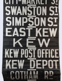
Functional object - Destination Roll, Melbourne & Metropolitan Tramways Board, 1960s
... / Wattle Park - Warragul Rd / Wattle Park - Elgar Rd / City... / Wattle Park - Elgar Rd / City / Burwood / Hartwell / Bowen St ...In an era predating the computerisation of equipment on public transport, where trams in Melbourne were driven by drivers and conductors sold fares, destinations were shown at the front and rear of the tram within a glazed box. A driver adjusted the roll to select each new trip destination. Given the length of rolls, in this case approximately nine metres, this could be a time consuming process. In addition to the named destination roll, each tram included a separate roll listing the route numbers.The roll was purchased at a Leski Auction in Armadale as part of a large group of tramways memorabilia including tram 'rolls' from New South Wales, Victoria, South Australia and Tasmania. The auction house described the collection as "The collection of destination blinds or rolls that forms the core of the Railways Trams & Buses Section (Lots 655 – 732) is the best we have ever offered and represents a life-time of collecting by an Adelaide enthusiast, now deceased." Melbourne & Metropolitan Tramways Board Tramways Destination Roll. Black and white paint on linen roll. Forty-eight named destinations including four depots - Camberwell, Hanna Street, Hawthorn, Kew. Multiple destinations in what is now the City of Boroondara (Kew, Hawthorn and Camberwell); including East Kew, Kew, Kew Post Office, Kew Depot, and Cotham Road.Named destinations beginning to end: “Olympic Park / Special / Football / Racecourse / Richmond / Burnley / Riversdale / Wattle Park - Warragul Rd / Wattle Park - Elgar Rd / City / Burwood / Hartwell / Bowen St / Camberwell Depot / Camberwell Jucn / Leura Grove / Gardener / Glenferrie Rd / Chapel St / St Kilda Rd / Camberwell / City / Lonsdale St / University / City via William St / Domain Rd / Hanna St Depot / South Melb & St Kilda Beach / Prahran / North Richmond / Windsor / Hawthorn Depot / Hawthorn / Spencer St / Toorak Rd / Swan & Church St Cnr / North Balwyn / City Flinders & Spencer Sts Corner / City - Market St / Swanston St / Simpson St / East Kew / Kew / Kew Post Office / Kew Depot / Cotham Rd / Malv Tn Hall"melbourne & metropolitan tramways board -
 Kew Historical Society Inc
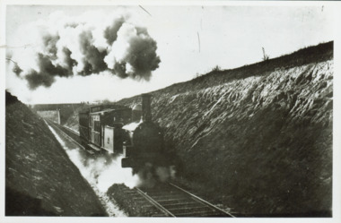
Photograph - Train coming up grade beyond Barnsbury Rd, Deepdene 1905
The Outer Circle Railway was opened in stages in 1890 and 1891, as a steam-era suburban railway line. It traversed much of the modern City of Boroondara, including the suburbs of (from north to south) Kew East, Camberwell, Burwood, Ashburton, and Malvern East. At its longest, it ran from Fairfield station, on what is today the Hurstbridge line, to Oakleigh station, on the current Pakenham and Cranbourne lines.Steam train in a cutting on the Outer Circle Railway line. Exhibition enlargement donated by Stewart West from an original owned by Miss Foley.trains, outer circle railway -
 Kew Historical Society Inc
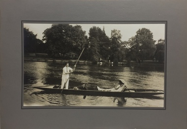
Photograph - John Duncan Brownlee and friends, Yarra River, The Artorium, 1920s
This mounted and framed photograph of a group of friends punting on the River Yarra has a number of historic and artistic associations. The photograph is primarily important as an informal photograph of the Australian baritone John Donald Mackenzie Brownlee (1900-1969), whose international career at the world's major opera houses from 1927 until his retirement in 1958 included singing at Melba's Covent Garden farewell in 1926, to recordings in the 1930s of a major series of Mozart operas in Glyndebourne Festival productions, conducted by Fritz Busch. Brownlee, born in Geelong, won the gold medal as champion vocalist at the South Street competitions in Ballarat in 1921. Moving to Paris in 1923 he began study with the French baritone, Dinh Gilly, making his operatic debut at the Trianon Lyrique in Montmartre in 1926. The most significant periods of his operatic career were with the Paris Opera from 1927 to 1936, and at the Metropolitan Opera from 1937 to 1957. After his move to Paris in 1923, he is recorded as revisiting Australia in 1928 as a member of the Melba-Williamson Company, and 24 years later in 1952. The photograph of Brownlee and the Gardners in a punt on the Yarra, while putatively dated to 1925, must be from earlier in the 1920s before his move to Paris, or later during the Melba-Williamson Company season. Before his move to Paris in 1923, Brownlee had lived in Belmont Avenue, Kew, where he must have developed a friendship with the Gardners. The photograph has additional artistic significance as it was produced at 'The Artorium', James Beament's design studio next to the Hawthorn Town Hall at 362 Burwood Road. With a home at 33 Uvadale Road (designed by Eric Nicholls, who managed the architectural practice of Walter Burley and Marion Mahony Grifffin from 1924 to 1932), Beament painted a number of significant murals for the Griffin practice, including those at the Capitol Theatre in Melbourne.A photograph of recreational activities on the River Yarra. The photograph is historically significant as a professionally produced photograph of the Australian operatic baritone John Brownlee, either before his move to Paris in 1923, or in 1928 during the Melba-Williamson Company operatic tour of Australia. The photograph has additional aesthetic significance as it was produced in James Beament's Hawthorn Studio - The Artorium - at 362 Burwood Road, next to the Hawthorn Town Hall.Framed photograph of John Duncan Brownlee, the Australian tenor, with Enid Gardner and friend in a punt on the Yarra River. Brownlee was born in Geelong but before his move to Paris in 1923, he lived for a period in Belmont Avenue, Kew. Three labels on reverse. 1. "John Duncan Brownlee, Operatic Star, originally of Geelong later resident of Kew at Belmont Av, on the pole. Also in the punt - Edith Gardner a friend. The Gardners lived on the east corner of Edgevale Rd. & Cotham. Approx. 1925." 2. "This picture is the property of Kew Historical Society 1/4/79". 3. Tel. Hawthorn 842 THE ARTORIUM ...."john brownlee (tenor), punting, recreation - yarra river (kew), james beament, the artorium -- 362 burwood road -- hawthorn (vic.) -
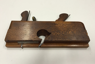 Kew Historical Society Inc
Tool, J Buck, Moulding Plane, 1/2" Rebate with scriber & depth adjust, 19th Century
In woodworking, a moulding plane is a specialised plane used for making the complex shapes found in wooden mouldings. Traditionally, moulding planes were blocks of wear resistant hardwood, often beech or maple, which were worked to the shape of the intended moulding. The blade, or iron was likewise formed to the intended moulding profile and secured in the body of the plane with a wooden wedge. A traditional cabinetmakers shop might have many, perhaps hundreds, of moulding planes for the full range of work to be performed.Bertie Robert Edgar Greenwood was born c. 1880/81 and died aged 82 in Hawthorn in 1963. His father and possibly his grandfather were also carpenters. Bertie’s work as a cabinetmaker required precise planing to give lovely edges and other elaborate decorations. The major item in the tool collection is Bertie’s wooden box, which houses 45 different moulding planes. Later in his life, he used these skills extensively when he worked as a patternmaker for a plastering company. Bertie worked through his seventies, retiring when he lost a finger. The tool collection was donated to the Kew Historical Society by Bertie’s granddaughter, Pamela Webster Bloom, a former resident of Kew.Plane - Wooden Moulding, Beechwood & Metal, 1/2" Rebate with scriber & depth adjust, J Buck 91 Waterloo Rd London. Stamped ‘4/8’. Also stamped with owner name ‘G. Greenwood’, with ‘G’ subsequently over-stamped with ‘B’. Later engraved number ‘15’ added on entering the collection in 2010.woodworking tools, moulding planes, bertie greenwood, carpentry, burwood road — hawthorn (vic.) -
 Royal District Nursing Service (now known as Bolton Clarke)
Photograph - Photograph, black and white, Barry Sutton, 1974
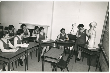
Sr. Pat (Paddy) Rowley is the Principal Nurse Educator at RDNS and is giving a lecture to RDNS Sisters in the Education Department at 452 St. Kilda Rd, Melbourne. She is wearing the RDNS summer uniform of a white short sleeve blouse under a royal blue V neck tunic style frock with the RDNS insignia on the upper left.Education was an integral part of Melbourne District Nursing Society (MDNS), from its inception in 1885, later, in 1966, called Royal District Nursing Service, (RDNS). From 1885, only Trained Nurses (Nurses), through the Hospital training system, were employed by the Society, and on visits to patients they taught the necessity of hygiene and cleanliness, as well as the need for a good diet, to bring about good health. Doctor’s lectures were later given at the MDNS home to instruct patients and their families on prevention of disease. Education to patients continued throughout the years regarding health care and the use of equipment in the home. In 1961, Education programs commenced at MDNS with Trained nurses (Sisters) receiving In-service education. Sr. Pat (Paddy) Rowley was a leader in In-service Education and established the RDNS Department of Community Nursing Education in 1962. Staff could also apply for scholarships to further their education outside of RDNS. Many of their senior Sisters received Postgraduate diplomas from the College of Nursing in Community Health Nursing, Education, and Administration, and several travelled overseas visiting nursing organizations viewing their public health and District nursing systems. At RDNS many programs were run, including: a Post Basic Course, Cardiac Rehabilitation Nursing, Haematology/Oncology Nursing, Palliative Care program, Diabetic Stabilization Program, Leg Ulcer Management Program, Wound Care Specialist Program, HIV/AIDS Nursing Care, Cystic Fibrosis Home Support, Veterans Home Care Program, Breast Cancer Support Program, Continence Management Program, Stomal Therapy Program, In-Home Lactation Support Program and the Homeless Persons Program. RDNS Sisters attended several hospitals to observe and learn special care needed to some patients, e.g. to the Austin Hospital to learn the care required for paraplegic and quadriplegic patients at home, and to Mount Royal Hospital to observe the care of patients in the Rehabilitation ward. A Community Nursing Education Program was extended to student nurses from hospitals and to other nursing organizations. These Education programs kept the RDNS Sisters abreast of new techniques, such as changes in technology for e.g. new testing methods in detecting glucose levels in Diabetic patients. Sr. Nan Deakin obtained a Post Basic Certificate in Psychiatric Nursing and included this area in her Education lectures. Sr. Daphne Geldard specialized in the area of Alzheimer’s disease and Dementia. These Sisters visited patients in District areas with the regular RDNS Sister when required. Every member of staff, both professional and non professional staff, received regular education in the Education Department. In 1980, a Home Health Aide pilot study, funded by the Federal Government, the Brotherhood of St. Laurence and RDNS, with the program written and taught by Sr. Rowley, was evaluated as successful, and Home Health Aides were employed and worked in RDNS Centres under the supervision of the RDNS Sisters. This black and white photograph shows Royal District Nursing Service (RDNS) Sister Pat (Paddy) Rowley and seventeen (some partly hidden), Royal District Nursing Service (RDNS) Sisters. The bulk of the photograph shows the front view of three rows of RDNS Sisters sitting at tables which have books and sheets of paper on them. The Sisters are wearing a variety of day clothes. In the right foreground of the Photograph is a table containing papers, and standing to its right, facing the group, is the back view of Sr. Rowley, who has short dark hair and glasses. She has her left hand on a sheet of paper on the table. She is wearing her RDNS uniform of a white short sleeve blouse under a dark tunic style frock. In the rear of the photograph a brick fireplace can be seen with some books and a vase of flowers on the mantelpiece. On the right is a long curtain, some lockers and an open wooden door with glass panel. Some of the Sisters named are:- Ann Greenwood, Judy Peter, Ethel Fullarton, Barbara Lovell, Shirley Lewis, Jane Ball..Barry Sutton Stamp. Quote LY 68royal district nursing service (1966-2017), rdns, rdns education, sister ethel fullerton, sister barbara lovell, sister shirley lewis, sister jane ball, sister pat (paddy) rowley, sister ann greenwood, sister judy peter -
 Royal District Nursing Service (now known as Bolton Clarke)
Photograph - Photograph, black and white, Barry Sutton, 1973
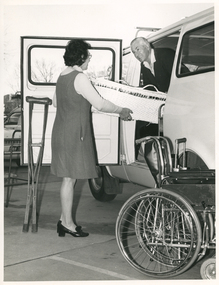
The photograph is taken in the car park at Royal District Nursing Service ( RDNS) Headquarters, 452 St. Kilda Rd, Melbourne. Sr. Harris is assisting to load the bassinet and the other nursing equipment into the RDNS Van for Mr. Pincher to deliver to the appropriate RDNS Centre or to patient's homes. In 1971 the Commission shop donated a Van to Royal District Nursing Service (RDNS), to be used by the Maintenance crew for delivery of equipment and transporting goods and documents between RDNS Centres and Headquarters. It was also used for transporting Maintenance staff, and the equipment they required, to do maintenance work at RDNS Centres as needed. The Commission Van was kept at the RDNS Service Centre at Chessell Street, South Melbourne. From the founding of the Melbourne District Nursing Society (MDNS), in 1885, known as the Royal District Nursing Service (RDNS) from 1966, equipment was loaned and demonstrated to patients, and their family members, to enable them to care for their loved ones in their home. In the 1970s RDNS employed a Physiotherapist who taught RDNS staff the correct transferring techniques, including the use of a hoist when this became available. RDNS staff taught and used these techniques in patient’s homes to undertake safe transfer of the patient and to reduce physical strain on RDNS Sisters and family members. Each RDNS Centre had a room or shed where equipment for loan was kept, and Headquarters also kept additional equipment which could be transported to Centres as required.On the left of the black and white photograph is Royal District Nursing (RDNS), Sister Betty Harris, who is standing side-on in front of the open door of a white Van. She wears glasses, has dark curled hair, and is smiling, as she has her arms outstretched with her right hand under a white bassinet as she passes it to Mr. Pincher who is standing in and leaning out of the opening of the Van. Mr. Pincher has wavy light colour hair and is smiling at Sr. Harris as he is holding the other end of the bassinet. He is wearing a dark cardigan over a white shirt. On the far left of the photograph, part of an RDNS car is seen and in front of this part of a walking frame. A pair of wooden crutches lean against the open Van door and a wheelchair and a 4 pronged stick are to the right of Sr. Harris. Behind them part of the Van with part of a window in its upper area are seen. Sr. Harris is wearing her RDNS uniform of a light grey skivvie under a darker V neck tunic style frock.rdns, royal district nursing service, rdns equipment, rdns uniform, sister betty harris, mr pincher -
 Royal District Nursing Service (now known as Bolton Clarke)
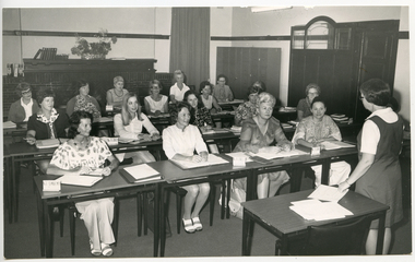
Photograph - Photograph, black and white, Barry Sutton, 14.09.1972
This black and white photograph shows a group of RDNS Sisters who are part of the Post Basic Community Nursing Course. They are receiving education from Sr. Pat (Paddy) Rowley, RDNS Principal Nurse Educator. The session is being held in the Education Department at the Royal District Nursing Service Headquarters, 452 St. Kilda Rd, Melbourne.The RDNS winter uniform worn is a blue/grey skivvie under a blue/grey V neck tunic style herringbone winter material frock.Melbourne District Nursing Service ran its first Post-Basic Course for community nurses in 1962. Sisters attended the course for 12 weeks. The course ran annually until the mid 1990s. Education was an integral part of Melbourne District Nursing Society (MDNS), from its inception in 1885, later, in 1966, called Royal District Nursing Service, (RDNS). From 1885, only Trained nurses (Nurses) through the Hospital training system, were employed by the Society, and on visits to patients they taught the necessity of hygiene and cleanliness, as well as the need for a good diet, to bring about good health. Doctor’s lectures were later given at the MDNS home to instruct patients and their families on prevention of disease. Education to patients continued throughout the years regarding health care and the use of equipment in the home. In 1961, Education programs commenced at MDNS with their Trained nurses (Sisters) receiving In-service education. Sr. Pat (Paddy) Rowley was a leader in In-service Education and established the RDNS Department of Community Nursing Education in 1962. Staff could also apply for scholarships to further their education outside of RDNS. Many of their senior Sisters received Postgraduate diplomas from the College of Nursing in Community Health Nursing, Education, and Administration, and several travelled overseas visiting nursing organizations viewing their public health and District nursing systems. At RDNS many programs were run, including: a Post Basic Course, Cardiac Rehabilitation Nursing, Haematology/Oncology Nursing, Palliative Care program, Diabetic Stabilization Program, Leg Ulcer Management Program, Wound Care Specialist Program, HIV/AIDS Nursing Care, Cystic Fibrosis Home Support, Veterans Home Care Program, Breast Cancer Support Program, Continence Management Program, Stomal Therapy Program, In-Home Lactation Support Program and the Homeless Persons Program. RDNS staff attended several hospitals to observe and learn special care needed to some patients, e.g. to the Austin Hospital to learn the care required for paraplegic and quadriplegic patients at home, and to Mount Royal Hospital to observe the care of patients in the Rehabilitation ward. A Community Nursing Education Program was extended to student nurses from hospitals and to other nursing organizations. These Education programs kept the RDNS Sisters abreast of new techniques, such as changes in technology for e.g. new testing methods in detecting glucose levels in Diabetic patients. Sr. Nan Deakin obtained a Post Basic Certificate in Psychiatric Nursing and included this area in her Education lectures. Sr. Daphne Geldard specialized in the area of Alzheimer’s disease and Dementia. These Sisters visited patients in District areas with the regular RDNS Sister when required. Every member of staff, both professional and non professional staff, received regular education in the Education Department. In 1980, a Home Health Aide pilot study, funded by the Federal Government, the Brotherhood of St. Laurence and RDNS, with the program written and taught by Sr. Rowley, was evaluated as successful, and Home Health Aides were employed and worked in RDNS Centres under the supervision of RDNS Sisters. This black and white photograph is of a group of seven Royal District Nursing Service (RDNS) Sisters sitting in a semi-circle in two rows at single small two shelf tables. There are open white paged books or papers on each table and some of the Sisters have pens in their hands. The Sister sitting in the front far right is Sr. Affleck, who has dark short curly hair. The other Sisters have dark short hair in various styles. Further right in the photograph stands Sr. Rowley, who has dark short hair and is wearing glasses. She has her left hand supporting a torso of an anatomical model which is sitting on a table slightly to her left. She and the Sisters are looking at the vertebrae down the spine of the model. Another empty table is in front of the semi-circle and it sits in the centre foreground of the photograph. In the rear between Sr. Affleck and Sr. Rowley, a piece of equipment stands on a table. To the right of the photograph part of a large blackboard can be seen. The Sisters are wearing light grey skivvies under a darker V neck tunic style frock with the RDNS insignia on its upper left.Photographers stamp. Quote No. LD 8rdns education, rdns uniform, royal district nursing service, sister pat (paddy) rowley, sister margaret affleck -
The 5th/6th Battalion Royal Victoria Regiment Historical Collection
Domestic object - Goblet wine - small white * 40, Stokes
... Collection 202 Burwood Rd Hawthorn melbourne Used for dining ...Used for dining in nightsGoblet - silver plated inscribed Sgts Mess HQ 3 DIV. Diameter 57Sgts Mess HQ 3 DIV