Showing 3431 items
matching distances
-
 Stawell Historical Society Inc
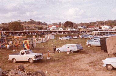
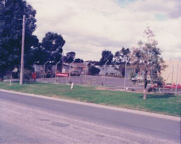
Slide, Ian McCann, Stawell Show
view across the oval at the stawell show, various cars in mid distance stawell show -
 Stawell Historical Society Inc
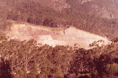
Slide, Ian McCann, The Dam Wall, 1965
Colour Slide/ showing the rock wall of the dam in the distance over trees.lake bellfield -
 Stawell Historical Society Inc
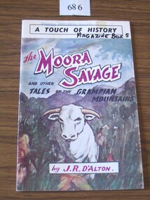
Book, J. R. D'Alton, The Moora Savage & other Tales of the Grampians Mountains by John R D'Alton, 1964
Cardboard cover with colored drawing of a white bull in bushland with mountains in the distanceA Touch of History. The Moora Savage and other Tales of the Grampian Mountains by J.R. D'Altonstawell -
 Ballarat Heritage Services
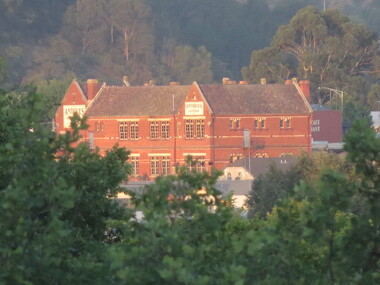
Photograph - Colour photograph, Former Humffray Street Primary School From Armstrong Street South, Ballarat, 2016, 07/02/2016
Photographs of the Former Humffray Street Primary School taken from a distance. school, education, humffray street primary school -
 Robin Boyd Foundation
Slide, Robin Boyd, 1956-1957
Robin Boyd developed a close friendship with the founder of the Bauhaus in Weimar Germany, Walter Gropius, who had moved to the USA in the 1930s. Through this connection, Boyd was invited to be the Massachusetts Institute of Technology (MIT) Bemis Professor at the School in the North American academic year 1956-7. Robin and Patricia Boyd, with their youngest daughter Suzy, were based in Cambridge, Massachusetts for the year. Boyd gave some lectures at MIT and he was also invited to give lectures at many other universities, allowing him to travel widely within the USA, especially on the East Coast. This gave him the opportunity to meet architects like Frank Lloyd Wright, Eero Saarinen, Paul Rudolph and many others, and visit the offices of Skidmore, Owings and Merrill, and places like Taliesin and the General Motors Technical Center Detroit. On the way home, the Boyds visited London, Berlin, Paris and Le Corbusier’s Ronchamp Chapel in France.Colour slide in a mount. Unknown location, USA. Patricia Boyd in the distanceMade in USA / 16mit bemis professorship, mit, robin boyd, slide -
 Mt Dandenong & District Historical Society Inc.
Photograph
The photograph is from the album of Ivy Child. It shows a homestead situated in a clearing at Kalorama in the late 1920s. Ivy May Child (1910 – 1989) was the daughter of Arthur Edward (Ted) Child (1878 – 1964) and Ethel May Madden (1888 – 1970). Ted Child was the son of Matthew Francis Child (1839 – 1933) and Martha Jeeves (1857 – 1926). He was the grandson of one of the early pioneers Francis Child. Ivy grew up on the family property on Childs Road and took many photographs. Most of these are glued into her photo album. The album covered the years from c1927 – 1932. Ivy married Henry William Burgess (1906 – 1968) in 1944. The photographs remain in their original state in the album with individual copies made. Sepia photograph with two large trees in the foreground framing a building in the distance.ivy child, kalorama, homestead -
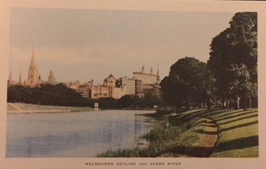 Kew Historical Society Inc
Postcard, Nucolorview Productions, Melbourne Skyline and Yarra River
One of a number of 'real photo' and commercial postcards created by or owned by members of the Christian and Washfold families of Kew. The postcards are part of a larger collection of photographs, postcards and publications donated to the collection in May 2021.Coloured matte postcard with skyline including State Theatre (Forum) in distance.postcards -- melbourne, yarra river, christian-washfold collection -
 Port Melbourne Historical & Preservation Society
Photograph - Swallow & Ariell and Stokes Street, Port Melbourne, Janet and Allen Walsh, Swallow and Ariell, 1973
Shot in 1973 with particular interest in architectureStokes St South West, Swallow and Ariell. Rotunda in distance. 1973 Identified and dated on back in inkbuilt environment - commercial, built environment - industrial, stokes street, band rotunda -
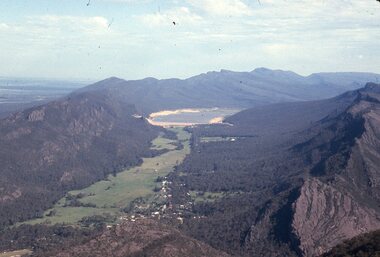 Stawell Historical Society Inc
Slide, Ian McCann, Aerial View of Lake Belfield in the distance, 1960's
Colour Slide: Aerial View of Grampians Valley with lake Bellfield in the distancegrampians, lake bellfield -
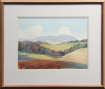 Federation University Art Collection
Painting - Watercolour, David Alexander, 'Mt Buninyong in Autumn' by David Alexander, 2001, 2001
Gift of Dr David Alexander, 2013Framed watercolour by David Alexander showing a landscape with Mount Buninyong in the distance. LRS 'D. Alexander'01art, artist, david alexander, watercolour, buninyong, mount buninyong, available -
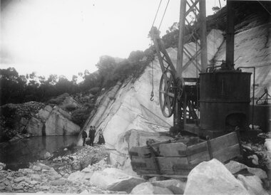 Stawell Historical Society Inc
Photograph, Picknickers outing at Heatherlie Quarry in the Mt Difficult Area, c 1914 -18
Picnic outing at Heatherlie Quarry Mt Difficult Area. Machinery near a rock pool. Three men and a ladyBlack and White Photgraph in a quarry with machinery in foreground and a group of people of in the distance.stawell grampians industry -
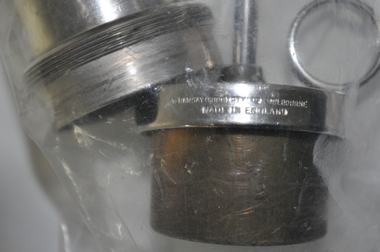 Kiewa Valley Historical Society
Aural Syringe with Nozzle
This medical / hospital instrument was used in the Tawonga District General Hospital which was built in the 1950s specifically for the increase in population due to the Kiewa Hydro Scheme.Historical: Shows the development of scientific hospital equipment. Provenance: Used in the Tawonga District General Hospital which was remote and therefore required good equipment. Good condition and good interpretation capacity.3 stainless steel parts in a sealed clear plastic bag. Used for an ear wash. 1. large hollow cylinder each end embossed with lines for something to be screwed on. 2. Plunger that fits inside cylinder & could screw on. 3. Top with a nozzle that screws on the other end.2. ?? / Made in England. Rod is marked with 4 inscriptions equal distance apart - measurements.hospital equipment. medical equipment. tawonga. mt beauty. aural syringe. ear. -
 Eltham District Historical Society Inc
Photograph, Main Road, Eltham South, near Eltham Park, flooded by the Diamond Creek, 30 Nov. 1934
Near Eltham Park (now known as Eltham Lower Park), floodwaters from the Diamond Creek cut off the Main road into Eltham at Bremner’s Flats (present day Wingrove Park). In the distance, left of centre, is Mr. Montieth's Ford Wagonette stranded in the floodwater near Wingrove Cottage. “On the Lower Eltham Reserve the water was nearly five feet deep across the reserve and over a mile along the road. All the week-end shops are surrounded. For over 40 years flood waters have not reached this unprecedented level.” - Advertiser, Friday November 30, 1934, p7 "Whilst we were at the shop a "tidal" wave occured . There used to be a Mr. Monteith who ran a Model T Ford bus from the Eltham Railway Station down the main street. The bus would hold seven, six seated in the back, 3 aside a seventh standing on the step on the middle of the back hanging on to two small hand rails. The bus was caught by the flood and was abandoned not far from our shop in the paddocks towards the Higher Elementary School. It was there for days and after the flood waters receded, Mr. Monteith, after removing all the mud and debris gave the engine one turn with the handle and it started first time! So the story goes! " (Doug Orford Reminiscences, 2004) The 1934 flood of the Diamond Creek and Yarra River is the highest recorded flooding in the district and set the standard for the current planning flood plain level.Black and white photograph showing the floodwater from Diamond Creek across Main Road in 1934. Left of centre shows Mr. Montieth's Ford Wagonette in the floodwater in the distancefloods, main road, eltham south, diamond creek (creek), wingrove cottage, wingrove park, bus services, bremner's flat, eltham park, ford wagonette, mr. montieth, floodwater, reminscences -
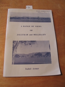 Stawell Historical Society Inc
Book, Isabel Armer, A Range of Views of Jallukar and Bellellen by Isabel Armer, 1996
History of the Jallukar and Bellellen areasGrey card cover with tow Photographs. The Top photo a panorama of a range of Mountains in the distance. the lower photo of a house and shed in the middle distance. The Title is between the two photos, the author is below the lower photo.A RANGE OF VIEWS OF JALLUKAR and BELLELLEN. Isabel Armerstawell -
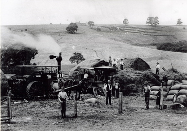 Sunbury Family History and Heritage Society Inc.
Photograph, The Nook
The photograph was taken in The Nook. Terence O'Brien rented the land from Goonawarra from the 1890s to 1905 where he grew cereal crops. The terraces on the hillside were built to grow vines when the property was one of the first vineyards in the area. The men in the image are from L-R: Mr. Heath in the white cutter owned the chaff cutter, John Leyden with hand on fence, Michael Dillon, Terence O'Brien and Phil Ratile are on top of the haystack, Andy Burke standing with hand on hip.The growing and harvesting of cereal crops was an important agricultural industry in the early days of Sunbury's settlement by both the Indigenous People and Europeans.A non-digital photograph black and white photograph of eleven men gathering hay with the aid of a steam traction engine in a wide open valley. A hillside in the distance has been terraced and there is a house on the hill in the distance.the nook, terence o'brien, andy burke, mr. heath, michael dillon, philratile, goonawarra, vineyards -
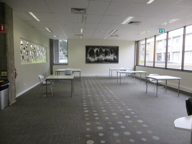 Federation University Historical Collection
Photograph, E.J. Barker Library prepared for Pre Covid19 Lockdown Social Distancing, 2020
The day after these photographs were taken Victoria when into lockdown to prevent the spread of Covid19.Colour photographs of the E.J. Barker Library prepared for Pre Covid19 Lockdown Social Distancing in March 2020. One in two pieces of furniture was removed so a distance of 1.5 metres could be maintained between people. covid19, oandemic, e.j. barker library., mount helen library, social distancing -
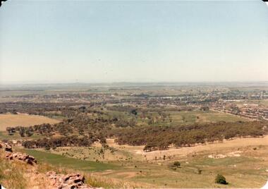 Hume City Civic Collection
Photograph, early 1980s
The Headland Estate housing development began in the early 1980s. It was situated west of Sunbury and was bounded by Elizabeth Drive, Reservoir Road, Phillip Drive and Stewart's Lane.A coloured landscape photograph with rounded corners of a view of Sunbury overlooking the Headland Estate before its development. There is a rocky outcrop on the LHS of the photograph and a lightly timbered area in the middle distance. Sunbury can be seen in the distance.headland estate, mt. holden, sunbury township, george evans collection -
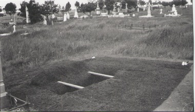 Sunbury Family History and Heritage Society Inc.
Photograph
The older fenced-off grave without a headstone is that of Cornelius Ford who had a private funeral when he was buried in Sunbury Cemetery on 7 December 1908, aged seventy-one. He is buried in Section H, plots 1 - 4. The registrar was McMahon and the undertaker was Trask. Cornelius Trask conducted a butcher's business in Brook Street and O'Shanassy Street. He also worked for some time as a publican at the Ball Court Hotel. He was also known as Gus.A non-digital black and white photograph of a recently dug grave in readiness for an internment. A short distance from the recently dug grave is a fenced-off grave without a headstone. There are a number of graves with headstones in the middle distance.ford, cornelius., sunbury cemetery -
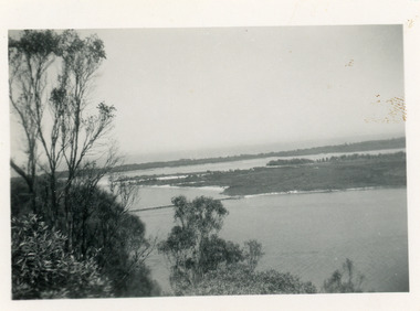 Lakes Entrance Historical Society
Photograph - Snake Island, 1950c
Also two other copies 7 x 11Black and white photograph showing eastern end of Rigby Island, Snake Island, and dunes at Lakes Entrance, Victoria. Reeves River below, foreground bushes, Hopetoun Channel in middle distance, Bass Strait in distance. waterways, topography, islands -
4th/19th Prince of Wales's Light Horse Regiment Unit History Room
Book, Modern Printing Pty Ltd, Signals Training Vol II Part II 1937 - Supplement, 1936
A hard covered book dealing with skip distances of short wave signals, with graphs.signals, short wave, skip distances -
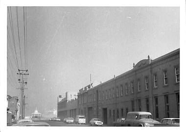
 Bendigo Historical Society Inc.
Photograph - CASTLEMAINE GAS COMPANY COLLECTION: PHOTO GAS AND FUEL SITE
Photo of Gas and fuel site taken from a distance. The Car park and a building.business, retail, gas and fuel -
Tatura Irrigation & Wartime Camps Museum
Photograph - copy, Dean Clark, copy 1989
Managers residence occupied by Mr and Mrs J. Lowry.Black and white photograph of north view of managers residence, Dhurringile Mansion in distance.On back: Nth view managers residence, Dhurringile Mansiondhurringile mansion, managers residence, lowry -
Numurkah & District Historical Society
Photograph - Photo of village & countryside
Black & White photo of a village taken from a distance, and showing surrounding countryside -
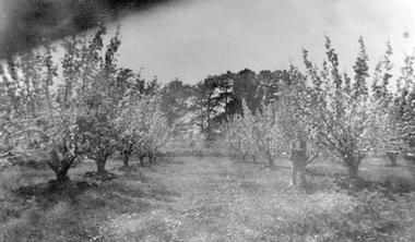 Stawell Historical Society Inc
Photograph, Cox’s Orchard in the Spring Pomonal
Cox’s Fruit trees in Orchard at Springtime Pomonal. A person is standing beside one of the fruit trees.Fruit trees in flower with man standing among trees. Pine trees in distance.Fruit trees in Springtime.stawell -
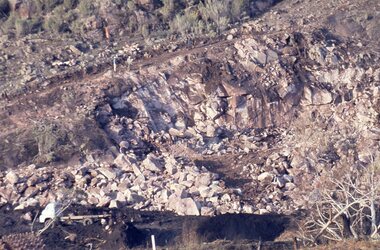 Stawell Historical Society Inc
Slide, Ian McCann, Constructing Lake Bellfield
Rocks to be moved during construction og Lake Bellfield, with two men in distancelake bellfield -
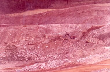 Stawell Historical Society Inc
Slide, Ian McCann, Lake Bellfield under constuction, 1965
Colour Slide. Showing lake Bellfied under constuction with steam shovel in the distance.lake bellfield -
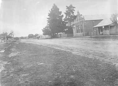 Stawell Historical Society Inc
Photograph, Main Street of Great Western 1920's
Taken at Great WesternShowing Great Western Hall and Harris House looking North. Shop in distance.streetscape -
 Kew Historical Society Inc
Photograph, Marnie McLeod, Floods of the River Yarra at Kew, 1916
The donation was accompanied by the following letter from the donor: "Hi. I found these in with family photos. Taken by family as Mamie McLeod was living in Fellows Street, Kew, so would be near there. Retain (or discard) as you see fit." [Donor's name and address withheld from public view]. To gain an insight into the flood levels at Kew, it is worth reading newspaper accounts of the event. The Age published an article - Valuable Gardens Destroyed at Kew - on 25 September 1916: "VALUABLE GARDENS DESTROYED AT KEW. From the heights of Studley Park, Kew, a splendid view of the flood waters can be obtained, and yesterday afternoon, despite continuous rain, crowds of citizens assembled there to witness the spectacle. There is a vast stretch of water some 300 or 400 yards broad, above the foot bridge connecting Gipps-street, Collingwood, and Studley Park. The river is only about 3 feet from the top of the embankment connecting with the ramp of the bridge on the Studiey Park side. When the upper llood waters come down it is almost a certainty that tne embankment will be submerged and the bridge rendered impassible. Below the bridge the waters again stretch out, and have submerged all the low-lying land on the Collingwood side and invaded the back premises ot the Kodak Co., Phoenix Biscuit Factory, a tannery adjoining thereto, the Shamrock Brewery, and Chinese gardens in the vicinity. At Walmer-street-bridge, at the end of Studley Park, the low-lying land on the Kew side is covered with water to the depth of many feet. Tlie land in question is owned in a great part by Mr Frank Lavers who haa gone in for intense culture on a pretty liberal scale on both the slopes of the hill and on the river flat. On the latter he is cultivating many acres of asparagus, and has at a considerable cost spent three years in preparing the ground and installing an irrigation system, reticulated from the Yan Yean water supply. This year the asparagus was put down, and the plants were in a promising condition. Tlie flood waters are now flowing fast over the land. The crop is ruined, and three years' work and expenditure destroyed. Mr. Laver's private residence fortunately is high above flood level, but two houses he owns off Young-street have been flooded out. Having been warned in time, the tenants removed their furniture hefore the water came down to Mr. Laver's residence, where they themselves have been given accommodation in the meantime. All the river flats in East Kew are under water. One or two low-lying houses have been flooded. Chipperfield's boat shed at Willsmere is nearly covered, and some Chinese gardens in the vicinity are several feet under water."This, and the other three photographs donated of floods in Kew are believed to be the earliest in the collection. Together with our original MMBW River Yarra map showing flood levels, these items, when compared allow researchers to gain a visual perspective of the extent of the flood in 1916. Black and white photograph of flooded trees in Kew with rising dry ground in distance.Inscription on reverse in pencil: "Flood River Yarra Kew Vic"river yarra, kew, floods 1916 -
 Port Melbourne Historical & Preservation Society
Photograph - Swallow & Ariell and Stokes Street, Port Melbourne, Janet and Allen Walsh, 1973
Shot in 1973 with particular interest in architectureStokes St South West, Swallow and Ariell and more. Rotunda in distance. 1973 Identified and dated on back in inkbuilt environment - commercial, built environment - industrial, stokes street, band rotunda, swallow & ariell ltd -
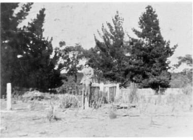 Linton and District Historical Society Inc
Photograph, Eva Simper
Black and white photograph of a woman wearing a hat sitting on top of a fence in distance."Eva Simper sitting on top of fence near well at Simpers old home site"eva simper