Showing 144 items
matching geographical society
-
 National Vietnam Veterans Museum (NVVM)
Film - Film, DVD, National Geographic: Vietnam's unseen war, pictures from the other side
... from the other side Film Film, DVD National Geographic Society ...Photos and film taken by Tim Page in the Vietnam Warvietnam war, 1961 -1975, war photography -
 Koo Wee Rup Swamp Historical Society
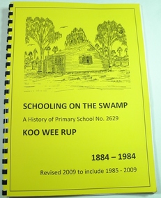
Book, Koo Wee Rup Primary School, Schooling On The Swamp, November 2009
History of Koo Wee Rup Primary School. Includes information about other schools (past and present) in Koo Wee Rup Swamp area : Bayles, Caldermeade, Cardinia, Catani, Cora Lynn, Dalmore East, Iona, Island Road, Koo Wee Rup North, Koo Wee Rup South, Heath Hill, Lang Lang, Protectors Plains, Modella, Tooradin, Tooradin North, Yannathan, Yannathan South. School Centenary History updated and expanded for 125 anniversary of Koo Wee Rup Primary School (1884-2009) Includes brief account of geography of Koo Wee Rup Swamp, and local indigenous people.A history of Primary School No. 2629, Koo Wee Rup : 1884 - 2009 (Revised for school 125th. anniversary - November 2009) compiled by Don Jewell. 62 pages, A4, plastic spring binding.koo wee rup primary school, centenary history -
 Bendigo Historical Society Inc.
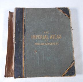
Book - Atlas, The Imperial Atlas of Modern Geography, 1860
Publisher Walter Graham Blackie (1816-1906) began as a letterpress operator, printer and publisher. He married Marion Brodie 16/4/1846. In 185, his successful business in Glasgow, employed 60 men and 40 boys.The Imperial Atlas of Modern Geography published in London by Blackie and Son, Warwick Square, E.C.; Glasgow and Edinburgh in 1860 MDCCCLX. The atlas includes an extensive series of maps embracing the most recent discoveries and the latest political divisions of territory in all parts of the world compiled and engraved from the most authentic sources. world maps, index -
 Bendigo Historical Society Inc.
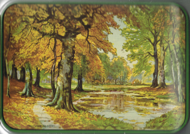
Photograph - LYDIA COLLECTION COLLECTION; LIFE IN OTHER LANDS
A green tin with a pictures of trees on the lid. The words 'Autumn Glory' are also written on the lid - 1. Series 1 - 12 'Life in other Lands.' A set of six photographs in each envelope. From pictures painted by E .S. Hardy. The All-British Picture Company Ltd., The Sunday School Union, 57/59 Ludgate Hill. London, E.C.4. 2. One envelope containing beautiful coloured reproductions of the paintings by E. Stuart Hardy. Titled 'Early Saints of History.' A.B. Shaw & Co., Ltd. 3, Creed Lane, Ludgate Hill, London, E.C.4. 3. Four black and white postcard size photographs of the process of making Guinness in a plain envelope.place, tin, lydia chancellor collection, collection, tin, photograph, photo, photos, photographs, guinness manufacturing, history, early saints of history, saints, st. columba, st. patrick, caedmon, st. augustine, st. benedict, st. francis, life in other lands, china, japan, africa, eskimos, inuits, south seas, india, geography, person, people, e. s. hardy, art, artwork, painting, place, societies -
 Bendigo Historical Society Inc.
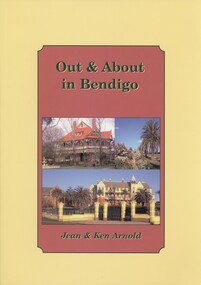
Book - OUT & ABOUT IN BENDIGO, 2007
Out & About in Bendigo. History of Bendigo and District. Plaques, monuments and head stones. Photographs. ISBN:978 1 875 342 69 3. Inscriptions: Ken Arnold December 2007.Ken & Jean Arnoldbendigo, history, bendigo, bendigo and district, plaques monuments headstones poppet heads fortuna geographical centre of victoria memorials -
Bendigo Historical Society Inc.
Map - VICTORIA, Circa 1926
Map: Map showing Counties, including Railway lines and Geographic features. Compiled and engraved at the Department of Lands and Survey Melbourne, Revised October 1926 ( number 184 in Map Cupboard 1)map, victoria, counties, counties of victoria, geographic features -
 Bendigo Historical Society Inc.
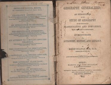
Book - HARRIS COLLECTION: GEOGRAPHY GENERALIZED
Book, 382 pages, brown board cover: ' Geography Generalized or an Introduction to the Study of Geography on the principles of classification and comparison with many illustrations through maps and illustrations' On front page in black pen ' Jonathan William Harris 1886' and ' Australia' written twice in same. Over page 'Jonathan W. Harris, his uncle. A gift from P.J. Murphy, 34 Little Oxford St., Collingwood. Jonathan W. Harris, August 26th, 1873' Published by Marcus and John Sullivan, 27 Marlborough Street, London. 1864Robert Sullivan, Barrister at Law.person, individual, jonathan harris, axedale -
Tatura Irrigation & Wartime Camps Museum
Book, Routledge Taylor and Francis Group, Fabrications, November 2016
Information about Prisoner of War and Internment Camp architecture and geography in the Pacific Carceral ArchipelagoWhite front cover with map. Pink and white spine and back coverThe Journal of the Society of Architectural Historians, Australia and New Zealand. In and Across the Pacificprisoner of war camps, internment camps, pacific carceral archipelago, anoma pieris, society of architectural historians, australia and new zealand -
 Wonthaggi & District Historical Society
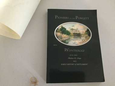
Book and Map, Barbara Moyle, Pioneers on tthe Powlett and at Wonthaggi 1878-1910, 2015
Book - families social histories, maps, photograps Map - block numbers town names physical / geographical featuresFarming and social history of pioneers of the Powlett River are prior to the establishment of the State Coal Mine at Wonthaggi. Significant land marks, buildings and photographs are included. Dark green cover with oval artists impression of Powlett river and bridge Associated map which covers the parishes plus key places of interestlPioneers on the Powlett and at Wonthaggi 1878-1910 Barbara R Moyle 2015 Early History of Settlement Map - Parish names, significant sitesfarming, pioneers of wonthaggi and district, wonthaggi families -
Stawell Historical Society Inc
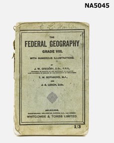
Book - School Book, The Austral Geography for class VI
Dulcie Baily Born Stawell 1919 Married Murris Trickey 1941 School Book Grade 6Blue Fabric, Card, paperDulcie Bailey PRICE 1/- The AUSTRAL GEOGRAPHY FOR CLASS VI. By J.W. Gregory D,Sc., F.R.S. ?? Professor of of Geology in teh University of Melbourne Melbourne Christchurch, Wellington, Durbin, ?? & London Whitcombe & Thomas Limited All Rights Reserved. J.W. Gregory D.Sc F.R.S. education, primary school -
 Stawell Historical Society Inc
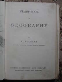
Book, A. Buckley, Class Book of Geography by A Buckley, 1888
Green Embossed Cover with cover framed by featuring stars in all corners surrounded by circles Title in centre. Clear tape on Spine.Hand written. To Ethel from Neil Feb 13th 1893. Ethel L (Struck though) Phillips State School 502 13 Feb 1893stawell education -
Koorie Heritage Trust
Book, Bader, Frances, Naming St. Kilda, 2007
Mentions the indigenous inhabitants of the area.i - vi; 214 P.; ports,; facs.; refs.; bib.; Mentions the indigenous inhabitants of the area. names, geographical -- victoria -- st. kilda. | st. kilda (vic.) -- name -- history. -
Koorie Heritage Trust
Book, Bulmer, John, Victorian Aborigines John Bulmer's Recollections 1855-1908, 1994
... Geographical Society of Australia."` xv, 98 p. : ill., map. figs ...Blurb: " John Bulmer began his missionary work in 1855, commencing a life dedicated to the Christianising of Victorian Aboriginal people at Yelta on the Murray, in the Wimmera and Monaro and at Lake Tyers in Gippsland. ...he recorded many of his recollections in thirteen papers, in correspondence with R. Brough Smyth and A. W. Howitt and in ... Royal Geographical Society of Australia."`xv, 98 p. : ill., map. figs.; tables; notes, word list; bib.;; 25 cm.Blurb: " John Bulmer began his missionary work in 1855, commencing a life dedicated to the Christianising of Victorian Aboriginal people at Yelta on the Murray, in the Wimmera and Monaro and at Lake Tyers in Gippsland. ...he recorded many of his recollections in thirteen papers, in correspondence with R. Brough Smyth and A. W. Howitt and in ... Royal Geographical Society of Australia."`bulmer, john, 1833-1913. | aboriginal australians -- missions -- victoria. | aboriginal australians -- victoria -- social life and customs. | aboriginal australians -- victoria -- social conditions. -
Whitehorse Historical Society Inc.
Document, Mountains District Police, 1991
History of Mountains District Police which comprises 2 geographical positions.History of Mountains District Police which comprises 2 geographical positions. Also includes history of Blackburn and Nunawading Police Stations.History of Mountains District Police which comprises 2 geographical positions. police, mountains district police, blackburn police station, nunawading police station -
Whitehorse Historical Society Inc.
Map, Nunawading Planning Scheme, 7/06/1994 12:00:00 AM
Local Section maps 1 - 4 with index. Geographical information system land Information Branch. Scale 1:10,000 Shows zoning under planning scheme.Local Section maps 1 - 4 with index. Geographical information system land Information Branch. Scale 1:10,000 Shows zoning under planning scheme.Local Section maps 1 - 4 with index. Geographical information system land Information Branch. Scale 1:10,000 Shows zoning under planning scheme.blackburn, blackburn north, blackburn south, forest hill, heatherdale, maps, nunawading, vermont, vermont south, town planning, burwood east, laburnum -
 Whitehorse Historical Society Inc.
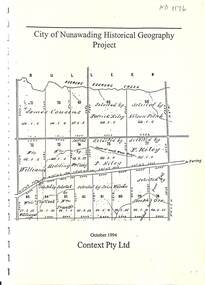
Document - Report, City of Nunawading Historical Geography Project, 1994
City of Nunawading Historical Geography Project : part of the City of Nunawading Heritage Awareness Study.A4 28 pages. City of Nunawading Historical Geography Project October 1994: part of the City of Nunawading Heritage Awareness Study. Consultants: Context Pty Ltd.City of Nunawading Historical Geography Project : part of the City of Nunawading Heritage Awareness Study.city of nunawading, environment, farming, clay, residential development -
Whitehorse Historical Society Inc.
Map, City of Nunawading Historical Geography Project
Periods covered 1834-1879. Early colonists to coming of railway, 1880-1918 Land boom, bust to WW1, 1919-1944 Part WW1 to end of WW2, 1945-present Post war suburban explosion - farming, clay industries,settlement.local history, heritage awareness study steering commitee, johnston chris, walker, vanessa, vosper, maria, kellaway, carlotta -
 Whitehorse Historical Society Inc.
Book - School textbook, The Federal Geography Grade VIII
UnknownExample of school textbook (C1950's?) undated.Comprehensive Grade VIII school textbook for Geography.E. C. Harristextbook, victorian, grade viii -
 Rutherglen Historical Society
Map, 1908
This is a map produced as part of a book entitled.. It is also stamped on the back in blue ink with an oval ring and the words North of England Institute. Newcastle. Mining & Meterolgical Faculty. Purchased on 23rd July 2017 by the Society after research by member Simon Killeen. Mining map of one of the first mines in Rutherglen area ( Chiltern West)Cream paper, black printing, rectangle with a drawingGeographical Survey of Victoria, Memoir, No6. Plate XX Plan of Underground Workings CHILTERN VALLEY CONSOLS MINE, RUTHERGLEN, PARISH OF CHILTERN WESTgold, rutherglen, mining, chiltern, underground mine map, geological survey, reef drives -
 Numurkah & District Historical Society
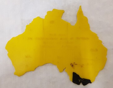
Equipment - Plastic stencil map/shape of Austalia
Yellow plastic stencil in the shape of Australia, states marked on the map, Victoria painted in blackState Savings Bank of Victoraeducation, school, geography, australia, stencil, drawing -
 Numurkah & District Historical Society
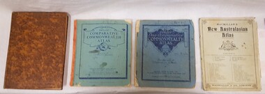
Book - School Atlases, Macmillan's New Australian Atlas / Phillip's New Comparitive Commonwealth Atlas (2) / The New Pictorial Atlas of the World
4 x World Atlas book. Cardboard covers & paper pagessee photoeducation, school, atlas, geography -
 Bendigo Historical Society Inc.
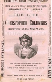
Book - LYDIA CHANCELLOR COLLECTION: THE LIFE OF CHRISTOPHER COLUMBUS
A book titled ' The Life of Christopher Columbus. Discoverer of the New World.' 'The Voyager, Astronomer, Geographer, whose genius widened the limits of the World to his own time and to subsequent ages.' Published London: Ward, Lock & Co., Salisbury Square, E.C. 369 - 383 pgs. This booklet is one of a series of 53 ' Ward & Lock's Penny Books for the People.' ' Biographical Series.' Price one penny. There are also advertisements of note.books, biography, christopher columbus, lydia chancellor, collection, history, explorers, famous people, astronomy, geography, exploration, christopher columbus, biographical series, biographies, ward & lock's penny books for the people, male, person individual, penny books, advertisements -
 Bendigo Historical Society Inc.
Book - Geographical dictionary
The Gazetteer presents an extensive a to z list of Victorian towns and villages, lakes, rivers and creeks, islands, bays, hills and mountains, runs and other localities and features. Entries include latitude and longitude, populations, proximity to other towns, local industries, coach and mail runs, hotels, churches and schools.Bailliere's Victorian Gazetteer and road guide containing the most recent and accurate information as to every place in the colony. Brown hardcover book, on the spine: Victorian Gazetteer with map 1865. The first and last pages are advertisements. The book has 442 pages listing every place in the colony. The map is not included. Compiled by Robert P. Whitworth. Published by Bailliere, Regent Street Unreadable name on first page and the name of F. Houston in blue pen on first page geographic dictionary, colony of victoria -
 Bendigo Historical Society Inc.
Slide - Bendigo College of Advanced Education - Landscaping, about 1986
Bendigo TAFE is a regional provider of vocational education, training and assessment services, located in northern and central Victoria, Australia. The institute has been in operation in various guises since 1854. The institute was known as the Loddon Campaspe Institute of TAFE from 1987 to 1990, Bendigo Regional Institute of TAFE (BRIT) from 1990 to 2009, before becoming Bendigo TAFE in 2009. Bendigo TAFE services a significant geographical area of approximately 25,000 square kilometres in central and northern Victoria, with a local population of 220,000. In May 2014, Bendigo TAFE announced that it would merge with the Melbourne-based Kangan Institute to form Bendigo Kangan Institute, however both institutes retain their existing branding.Bendigo College of Advanced Education (BCAE) early years - 24 slides of Landscaping at the new premises in Nolan Street Bendigo (Now the Bendigo Tertiary and Further Education (TAFE). history, bendigo, bendigo college of advanced education, bcae, landscaping, bendigo tafe -
 Bendigo Historical Society Inc.
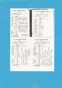
Document - GOLDEN SQUARE LAUREL STREET P.S. COLLECTION: EXAMINATION CARDS
Four white photocopy examination cards laminated upon blue cardboard and printed, SS 1189 , Golden Square, years 1941-42. Each outlines numbered marks out of ten for student named Elaine Rudd for subjects, Reading, Recitation, Spelling, Writing, Composition, English, Arithmetic A-B-C-D, History, Geography, Handwork, Art. B Rutherford and F Baggaley signatures. Written note states, 'Position; 3rd in class of 45. Excellent result. Elaine has done good work all the year. She seems to be very interested in her school work. Initialled FB.bendigo, institutions, golden square primary school -
 Bendigo Historical Society Inc.
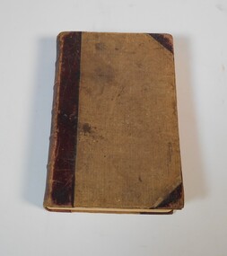
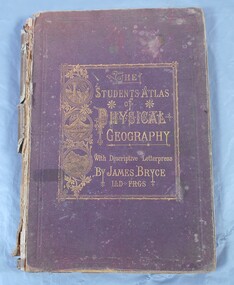
Book - Atlas of Physical Geography
The student's atlas of physical geography consisting of twenty maps, constructed and engraved by Edward Weller F.R.G.S. with descriptive letterpress by James Bryce L.L.D F.R.G.S. Published by William Collins, Sons & Company, London, Glasgow and Edinburgh 1871. Brown cover with the title of the book in gold letters. to the left of the title, also in gold, three circles with different pictures inside. the first of two boats on the sea, a volcanic eruption and a mountain peak.On first page in pencil the name Carrie Van Damme.geography, atlas, 1871 -
 Bendigo Historical Society Inc.
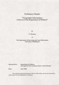
Document - FORTUNA COLLECTION: DOCUMENT
Document - titled : Preliminary Results 'Geographic Information: A Survey of the Department of Defence' Additional written information on title page reads: 'by P. Thwaites at The Deparment of Surveying and Land Information University of Melbourne. Sponsored by: Deparment of Defence (through the Post Graduate Study Award Scheme, Date: June 1988. ' Document is 17 single pages in length including a Contents page. -
 Kew Historical Society Inc
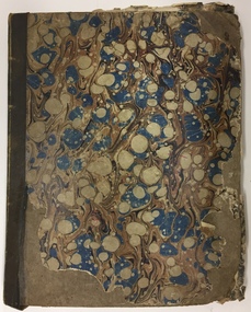
Album, Louisa G Thomas, Victorian Era Sketchbook, 1862
Louisa Thomas married Henry Gipps (1837-91)in 1863. They had six sons and two daughters. While Louisa and Henry Gipps were to die in Sussex, two of their sons, Frederick George De Visme Gipps (1867-1953) and Richard Brook Woodthorpe Gipps (c.1872-1946) migrated to Queensland, possibly bringing with them their mother’s sketchbook.The collection of artworks that are included in the sketchbook are often of outstanding aesthetic and artistic significance. In the variety of subject matter and the geographical places represented, it is historically significant as a document recording the postings of Colonel Henry Gipps, 9th Norfolk Regiment, and his wife Louisa to locations in the Mediterranean and West Asia. The large bound sketchbook has a marbled cover with blue binding. The name Louisa Goulburn Thomas and the date 1862 are faintly inscribed in pencil on the front page. However the book contains pen and ink and pencil drawings, watercolours, and photographs, which both predate and postdate 1862. The approximately 75 works are loose-leafed items and [currently] do not form a chronological, geographical or thematic sequence. Creators identified on some drawings and watercolours include Mary Julia Wilder Thomas, JFV Wright, ELG (Edward Louis de Bondell Gipps?), L Nicholson, Bertha Isadore Thomas, and HG (Henry Gipps?). Many of the works are signed and dated, and include rural landscapes and seascapes, archaeological sites, animal studies, and portraits. While most of the works were created in the British Isles, others are scenes of Venice, the Ionian Islands, Cape Town, Hong Kong and Japan. [A number of the ‘oriental’ paintings on silk were probably purchased from local artists.] The art works in the book are at various stages of completion and represent a diverse range of artistic skills. What may be the earliest work in the sketchbook is a drawing of three uniformed soldiers. An annotation on the reverse records that the drawing is of a Group of Soldiers after [Philipp Jakob] de Southerbourg 1830. The birth of Louisa Thomas' oldest son, William Henry Houston Meyrick Gipps (1864-1903) in Corfu perhaps explains why a number of scenes and items in the album are of the Ionian Islands. Louisa is probably the creator of a number of still life and botanical studies in the album. These range from floral studies to a bird’s nest. The painting of objects was to remain a socially ‘approved’ specialty of amateur and professional women artists into the 20th century. The complete contents of the album will be uploaded to accompany this record. Some items may be published separately on Victorian Collections, but will acknowledge their origins in the sketchbook."Louisa Goulburn Thomas / 1862"victorian sketchbooks, manuscripts - kew historical society, 9th norfolk regiment, rosemary (gipps) vaughan smith, vaughan-smith collection -
Kew Historical Society Inc
Archive (Series) - Subject File, Kew Historical Society, Histories of Kew, 1958
Various partiesReference, Research, InformationSecondary Values (KHS Imposed Order)Subject file containing short general histories of Kew, or geographic parts thereof, and timelines compiled by various individuals, some of who were members of the Kew Historical Society. Authors of content include Isaac Selby, Dorothy Rogers, Dione McIntyre and Graeme Lindsay. Other authors are not identified. Some of these histories were used on annual bus trips of the suburb during the Kew Festival. Notes on specific aspects of Kew’s history relate to early exploration, settlement in Cotham Road, the influence of the environment, northern and eastern Kew and Studley Park. The majority of these monographs remain unpublished texts. The file also contains summaries and or transcripts of talks given to the Society by Geoff Clarke (1975) and Allan Wakefield about their recollections of Kew’s history.kew (vic) - history, kew - early landowners, kew - environmental history, geoff clarke, allan wakefield, kew historical society - members, kew historical society - researchkew (vic) - history, kew - early landowners, kew - environmental history, geoff clarke, allan wakefield, kew historical society - members, kew historical society - research -
 Kew Historical Society Inc
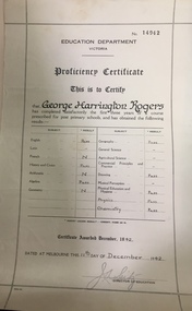
Certificate, Education Department (Victoria), Proficiency Certificate: George Harrington Rogers, 11/12/1942
This document was donated to the Kew Historical Society by John Rogers in 2015. Primary source for understanding the requirements of educational standards in Victoria in the 1940sEducation Department Victoria. Proficiency Certificate No.14942 This is to Certify that George Harrington Rogers has completed satisfactorily the first three years of a course prescribed for post primary school, and had obtained the following results. Pass - English, History and Civics, Algebra, Geography, Drawing, Physical Education and Hygiene, Physics, Chemistry. Certificate awarded 1942. Dated at Melbourne this 11th Day of December 1942. Signed Director of Education.certificates - education department victoria, proficiency certificates, george harrington rogers