Showing 296 items
matching geological survey.
-
 Bendigo Historical Society Inc.
Map - FORTUNA HUSTLER'S MINE - LONGITUDINAL SECTION OF THE FORTUNA HUSTLER'S MINE
... Geological Survey of Victoria... ton and some geographical features. Geological Survey... Section of the Fortuna Hustler's Mine Geological Survey ...Longitudinal Section of the Fortuna Hustler's Mine on the Hustler's Line of Reef, Bendigo. Bulletin No 33, Plate No IV. Shows poppet legs at the surface level, Datum Line 750 feet above Sea Level, levels and their depths, the amount of gold per ton and some geographical features. Geological Survey of Victoria emblem and signed by H A Whitelaw, Underground Survey Office, Bendigo. Note - Plates 4, 8, 13, 20, 26 & 31 form a Longitudinal Section from Fortuna Hustler's to Hustler's Consols Mine. mining, parish map, fortuna hustler's mine, longitudinal section of the fortuna hustler's mine, geological survey of victoria, h a whitelaw, underground survey office bendigo, hustler's line of reef, hustler's consols mine -
 Bendigo Historical Society Inc.
Map - HUSTLER'S REEF & HUSTLER'S REEF NO 1 MINES - PLAN OF THE HUSTLER'S REEF & HUSTLER'S REEF NO 1 MINES
... Geological Survey of Victoria... in relation to the shaft. Geological Survey of Victoria emblem... Mines Geological Survey of Victoria Underground Survey Office ...Plan of the Hustler's Reef & Hustler's Reef No 1 Mines on the Hustler's Line of Reefs Bulletin No 33, Plate No XV. Plan shows the two mines with depth of levels, geological features and levels in relation to the shaft. Geological Survey of Victoria emblem and signed by H A Whitelaw, Underground Survey Office Bendigo, September 1913. Note - The Lease Boundaries shown on this plan are only in their approximate relative positions to Nos 13, Intermediate and 14 Levels of the Hustler's Reef No 1 workings, and Nos 15, 16 and 17 Levels of the Hustler's Reef workings.mining, parish map, hustler's reef & hustler's reef no 1 mines, geological survey of victoria, underground survey office bendigo, h a whitelaw, hustler's line of reefs -
 Bendigo Historical Society Inc.
Map - HUSTLER'S REEF NO 1 MINE - TRANSVERSE SECTION OF THE HUSTLER'S REEF NO 1 MINE
... Geological Survey of Victoria... encountered. Geological Survey of Victoria emblem H Herman, Director... of Reefs Geological Survey of Victoria Underground Survey Office ...Map of a transverse Section of the Hustler's Reef No 1 Mine on the hustler's Line of Reefs Bulletin No 33, Plate No XXI. Map shows poppet legs at 801.07 feet above Sea Level and drawing of shaft with the different levels. Also shown are geological features and stone encountered. Geological Survey of Victoria emblem H Herman, Director, W Dickson, Secretary of Mines and The Hon. J. Drysdale Brown MLC Minister of Mines. Signed by H S Whitelaw, Underground Survey Office Bendigo, September 1913. This item has not been scanned or photographed.mining, parish map, hustler's reef no 1 mine, hustler's line of reefs, geological survey of victoria, underground survey office bendigo, h s whitelaw, h herman, w dickson, the hon j drysdale brown -
 Bendigo Historical Society Inc.
Map - HUSTLER'S ROYAL RESERVE NO 2 (PARK SHAFT.) - TRANSVERSE SECTION OF THE HUSTLER'S ROYAL RESERVE NO 2
... Geological Survey of Victoria... encountered including lava and geological features. Geological Survey....) H S Whitelaw Underground Survey Office Bendigo Geological ...Transverse section of the Hustler's Royal Reserve, No 2 (Park Shaft.) on the Hustler's Line of Reef. Bulletin No 33, Plate No IX. Section shows poppet legs and sill of shaft at 755.70 ft above sea level, depth of levels, type of stone encountered including lava and geological features. Geological Survey of Victoria emblem and beneath it H. Herman, Director, W. Dickson, Secretary of Mines and The Hon. J. Drysdale Brown MLC Minister of Mines and signed by H S Whitelaw, Underground Survey Office, Bendigo September 1913.mining, parish map, hustler's royal reserve no 2 (park shaft.), h s whitelaw, underground survey office bendigo, geological survey of victoria, h herman, w dickson, the hon j drysdale brown mlc, hustler's line of reef -
 The Beechworth Burke Museum
Geological specimen - Basalt, Unknown
... Geological survey / [illegible] /... Geological survey / [illegible] / A smaller than hand sized rock ...Basalt is a common igneous rock that composes most of the Earth's surface and can be found on the Moon and other rocky planets of the Solar System. It is generally composed minerals such as calcic plagioclase, clinopyroxene and iron ore which form grains that are indistinguishable to the naked eye. It can be dark grey or black in colouring and sometimes may contain holes left by gas bubbles. Most of the Earth's basalt was produced in environments such as oceanic divergent boundaries, oceanic hotspots, and mantle plumes and hotspots beneath continents. Basalt is commonly used in construction where it is crushed and used for multiple purposes such as concrete aggregate, road base, or railroad ballast. Thin slabs of basalt can also be cut and used for floor tiles, stone monuments, and building veneer. This particular specimen was excavated from Talbot in Victoria, which was a small gold mining town established in 1852. As basalt is a common rock, it is not specific to Talbot. However, this specimen can be assumed to be of the Cainozoic age due to previous geomorphic surveys of the area. This particular type of Basalt was used mainly for roads due to the durability of the rock.Basalt holds significance due to the continued use of the rock from historic until present times. The rock has been utilised for many types of construction and is still used for the same purposes today. Basalt also has significance to the Earth and other rocky planets of the Solar System as it makes up most of the planet's surface. This specimen is part of a larger collection of geological and mineral specimens collected from around Australia (and some parts of the world) and donated to the Burke Museum between 1868-1880. A large percentage of these specimens were collected in Victoria as part of the Geological Survey of Victoria that begun in 1852 (in response to the Gold Rush) to study and map the geology of Victoria. Collecting geological specimens was an important part of mapping and understanding the scientific makeup of the earth. Many of these specimens were sent to research and collecting organisations across Australia, including the Burke Museum, to educate and encourage further study.A smaller than hand sized rock specimen which is dark grey in colour with small holes and white deposits across its surface.Geological survey / [illegible] /burke museum, beechworth, geological specimen, geology, basalt, basalt specemin, indigo shire, talbot, cainozoic, igneous rock -
 Bendigo Historical Society Inc.
Map - COMET MINE - LONGITUDINAL SECTION COMET MINE
... Geological Survey of Victoria... Geological Survey of Victoria Longitudinal section of the Comet Mine ...Longitudinal section of the Comet Mine on the Hustler's Line of Reef Bulletin No 33, Plate No XXVI signed by H. S. Whitelaw, Underground Survey Office Bendigo, September 1913. Map shows datum lines, depths of levels, approximate boundaries and references to other plans. Note - Plates 4, 8, 13, 20, 26 and 31 form a Longitudinal Section from Fortuna Hustler's to Hustler's Consols Mine. Geological Survey of Victoriamining, parish map, hustler's line of reef, longitudinal section of comet mine bulletin no 33 plate no xxvi, h s whitelaw -
 Bendigo Historical Society Inc.
Map - COMET MINE - TRANSVERSE SECTION COMET MINE
... Geological Survey of Victoria... Geological Survey of Victoria Transverse section of the Comet Mine ...Transverse section of the Comet Mine on the Hustler's Line of Reef Bulletin No 33, Plate No XXV signed by H. A. Whitdon, Underground Survey Office Bendigo September,1913. Map shows depth of the different levels, the type of stone and shaft about 2020 deep. A number of smaller drawings on the side. Reference explaining the different types of stone, etc. Geological Survey of Victoriamining, hustler's line of reefs, transverse section of comet mine bulletin no 33 plate no xxv, lightning hill line of reef -
 Bendigo Historical Society Inc.
Map - COMET MINE - PLAN OF COMET MINE
... Geological Survey of Victoria... Geological Survey of Victoria Plan of the Comet Mine on the Hustler's ...Plan of the Comet Mine on the Hustler's Line of Reefs Bulletin No 33, Plate No XXIII. Map shows depths, Lightning Hill Anticline, Hustler's Anticline and approximate Lease Boundary. Signed by H. S. Whitelaw, Underground Survey Office Bendigo, September 1913. United Hustler's & Redan Co and Hustler's Reef Co also named on map. Geological Survey of Victoriamining, hustler's line of reefs, comet line plan belletin no 33 plate no xxiii, lightning hill anticline, hustler's anticline, united hustler's & redan co, hustler's reef co, h s whitelaw -
 Bendigo Historical Society Inc.
Map - COMET MINE - PLAN OF COMET MINE
... Geological Survey of Victoria... Bulletin No 33 Plate No XXIV Geological Survey of Victoria Plan ...Plan of the Comet Mine on the Hustler's Line of Reefs Bulletin No 33, Plate No XXIV signed by H S Whitelaw, Underground Survey Office Bendigo, September 1913. Upper and Lower Levels and approximate boundaries shown. Depths shown.Geological Survey of Victoriamining, parish map, hustler's line of reefs, comet mine plan bulletin no 33 plate no xxiv -
 Federation University Historical Collection
Map - Plan, Ballarat Deep Leads and Mines, 1992, 1992
... Geological Survey - Gold Deposits in Victoria... of the Geological Survey of Victoria mines database, references and geology... Survey of Victoria mines database, references and geology ...This is Bulletin No. 62: Deep Lead Gold Deposits in Victoria. Map No.6 Ballarat Sheet 1 of 2 The map shows geology, topography and information on mines in the following areas: one large map of the Ballarat area with five enlargements for: Sago Hill District; Scarsdale District; Pitfield Plains District; Berringa Gold Field and Rokewood District. Ballarat Mines and Deep Leads Report No.94 (Finlay and Douglas,1992) provides a summary of the Geological Survey of Victoria mines database, references and geology for most of the mines on this map. Geology Compilation: simplified from earlier Departmental mapping with minor field checking by E.N.M. Plier-Malone. Very large rectangular sheet of paper with seven coloured maps of various sizes and a small green rectangle on the bottom rhs with a map of Victoria superimposed over a poppet head. this rectangle includes information of the other maps shown. The background for these maps is white. Also includes tables of names of mine companies, name of shafts and gold production.gold mines of australia, gold mines of victoria, gold mines- ballarat and district, gold mines pitfield plains district, gold mines scarsdale district, gold mines berringa gold field, gold mines rokewood district, gold mines sago hill district, map - gold mines, map - gold mines in victoria, ballarat, pitfield, scarsdale, berringa, rokewood, sago hill, deep lead gold deposits in victoria, geological survey - gold deposits in victoria, mining, gold deposits in victoria, gold mines in victoria, rokewook, pitfield plains -
 The Beechworth Burke Museum
Geological specimen - Slice Dendrites on Sandstone, Unknown
... Geological Survey of Victoria... by Alfred Selwyn in 1868 as part of the Geological Survey... by Alfred Selwyn in 1868 as part of the Geological Survey ...Dendrites are deposits of black minerals, typically manganese oxides that precipitated from water seeping through fractures in fine-grain rocks like a sandstone or limestone. Dendrites are much less regular than plant fossils and lacks vein structures. The manganese cryztallizes through the process called 'supercooling'. Some samples of dendrites occur in volcanic rocks in the Lilydale district, east of Melbourne. Sandstones are made of tiny sand grains that may have been deposited in the sea and later formed together. Most sandstones are made of quartz which are chemically-resistant minerals. This particular specimen was donated by Alfred Selwyn in 1868 as part of the Geological Survey of Victoria. It is connected to the original 1875 catalogue on Geological Specimen with number 189 'Quartz Crystals_Quartz Crystals (two are polished)'Dendrites on sandstones This specimen is an important contribution to the geological history of Victoria, as well as its links to the 1868 Geological Survey of Victoria. This specimen is part of larger collection of significant geological specimens in the Burke Museum that was collected from around the world between 1868-1880. A large percentage of these specimens were collection as part of the Geological Survey of Victoria 1852-1974. The Geological Survey of Victoria was an organisation founded in response to the Victorian gold rush to explore the geological and mineral resources and to record a detailed map of the state. It was headed by British geologist, Alfred Richard Cecil Selwyn (1824-1902), who was responsible for issuing over 60 geological maps during his 17 years as director. These maps were all hand-drawn and coloured and became the benchmark for accuracy for geological mapping. Collecting geological specimens was an important part of mapping and understanding the scientific makeup of the earth. Many of these specimens were sent to research and collecting organisations across Australia, including the Burke Museum, to educate and encourage further study. A hand-sized slice of light brown sandstone with dendrites formed from crystallized manganese oxide.Existing label: Not sure what / 'Slica dondrites' / means. / Sample is sandstone and original label / identifies it as from / the Grampians near Stawell. / C. Willman / 15/4/21 Other label: [illegible] / stone [ illegible] / from Grampians Stawell / 1894 /geological specimen, geology, geology collection, burke museum, beechworth, dendrites, sandstones, quartz, lilydale district, geological survey of victoria, grampians, victoria rocks, minerals, rocks, manganese oxides, alfred selwyn -
 Bendigo Historical Society Inc.
Map - HUSTLER'S REEF & HUSTLER'S REEF NO 1 MINES - PLAN OF THE HUSTLER'S REEF & HUSTLER'S REEF NO 1 MINES
... Geological Survey of Victoria..., Bendigo, September 1913. Geological Survey of Victoria emblem. ... Co. H A Whitelaw Underground Survey Office Bendigo Geological ...Plan of the Hustler's Reef & Hustler's Reef No 1 Mines on the Hustler's Line of Reefs, Bendigo Bulletin No 33, Plate No XIV. No 8 connecting No 10 (Hustler's Reef), No 11 connecting No 13 (Hustler's Reef), No 13 (Hustler's Reef No 1) connecting No 15 (Hustler's Reef) and No 10 Hustler's Reef No 1 rise to Comet Mine. Map shows different levels in relation to the two shafts, the lines of the Hustler's Line of Reefs and the Lightning Hill Line of Reefs, the approximate Boundary of Lease and the Comet Co., the adjoining lease. Table on the left shows the levels and their depths of the two mines. Signed by H A Whitelaw, Underground Survey Office, Bendigo, September 1913. Geological Survey of Victoria emblem. mining, parish map, hustler's reef & hustler's reef no 1 mines, hustler's line of reefs lightning hill line of reefs, comet co., h a whitelaw, underground survey office bendigo, geological survey of victoria -
 Bendigo Historical Society Inc.
Map - GREAT EXTENDED HUSTLER'S MINE - TRANSVERSE SECTION OF THE GREAT EXTENDED HUSTLER'S MINE
... Geological Survey of Victoria... drawing of sections of the crosscuts, Geological Survey... Mr Craven Geological Survey of Victoria Underground Survey ...Transverse Section of the Great Extended Hustler's Mine on the Hustler's Line of Reef. Bulletin No 33, Plate No XII. Shows Poppet legs at the surface and Sill of Shaft at 788.99 feet above Sea Level, Cross Cuts and their depths, stone and geographical features encountered and their references and a number of enlarged drawing of sections of the crosscuts, Geological Survey of Victoria emblem and signed by H A Whitelaw, Underground Survey Office Bendigo, September 1913. The depths of crosscuts to No 21 were taken from plans of surveys by Mr. Walker and Mr. Craven, noted under Reference. Another note: This Saddle Reef is sketched from Mr. Walker's plan. Dividends amounting to 360,000 pounds were obtained from it. mining, parish map, great extended hustler's mine, transverse section of the great extended hustler's mine, old shaft, mr walker, mr craven, geological survey of victoria, underground survey office bendigo, h a whitelaw -
 Bendigo Historical Society Inc.
Map - UNITED HUSTLER'S & REDAN & K. K. MINES - PLAN OF THE UNITED HUSTLER'S & REDAN & K. K. MINES
... Geological Survey of Victoria... to Hustler's Consols Mine. Geological Survey of Victoria emblem... Geological Survey of Victoria H S Whitelaw Underground Survey Office ...Plan of the United Hustler's & Redan & K. K. Mines Bulletin No 33 Plate No XXXI. Shows depth of levels, Probable positions of reefs and natural surface with the poppet legs at the two shafts. Sill of shaft of the K. K. Mine 773.56 ft above Sea Level and sill of shaft of the United Hustler's & Redan Mine 745.62 above Sea Level. Also mentioned is the average amount of gold obtained per ton. Note on the top of page - Plates 4, 8, 13, 20, 26 & 31 form a Longitudinal Section from Fortuna Hustler's to Hustler's Consols Mine. Geological Survey of Victoria emblem and signed by H S Whitelaw, Underground Survey Office, Bendigo, September 1913. mining, parish map, united hustler's & redan & k. k. mines, geological survey of victoria, h s whitelaw, underground survey office bendigo -
 Bendigo Historical Society Inc.
Document - HUSTLERS REEF - PLANS & SECTIONS TO ACCOMPANY BULLETIN NO 33
... Geological Survey of Victoria... Geological Survey of Victoria 1914. Written on the back: Lightning... Bulletin No 33 Geological Survey of Victoria Department of Mines ...Pink page pasted onto cream card titled Plans and Sections to accompany Bulletin No 33. Hustler's Line of Reef, Bendigo by H S Whitelaw, by Authority: Albert J. Mullett, Government Printer, Melbourne. Plate No 1 to No 34. Mines mentioned: Fortuna Hustler's Mine, Hustler's Royal Reserve No 2 Mine, Hustler's Royal Reserve Mine Park Shaft, Great Extended Hustler's Mine, Hustler's Reef and Hustler's Reef No 1 Mines, Hustler's Reef Mine, Comet Mine, United Hustler's and Redan Mine, K. K. Mine, Hustler's Consols Mine, Fortuna Hustler's Mine. Department of Mines Geological Survey of Victoria 1914. Written on the back: Lightning Hill area to Summer Hill.document, hustlers reef, plans & sections to accompany bulletin no 33, geological survey of victoria, department of mines, hustler's line of reef, h s whitelaw, fortuna hustler's mine, hustler's royal reserve no 2 mine, hustler's royal reserve mine park shaft, great extended hustler's mine, hustler's reef mine, hustler's reef no 1 mine, comet mine, united hustler's mine, redan mine, k k mine, hustler's consols mine, fortuna hustler's mine, hustler's consols mine, albert j mullett, government printer melbourne -
 Bendigo Historical Society Inc.
Map - GREAT EXTENDED HUSTLER'S MINE - LONGITUDINAL SECTION OF THE GREAT EXTENDED HUSTLER'S MINE
... Geological Survey of Victoria... mentioned. Geological Survey of Victoria emblem and signed by H... of gold mined mentioned. Geological Survey of Victoria emblem ...Longitudinal Section of the Great Extended Hustler's Mine on the Hustler's Line of Reefs. Bulletin No 33, Plate No XIII. Map shows the Hustler's Tribute, 2 Old Shafts, Great Extended Hustler's Shaft, Latham & Watson's Shaft and Ironbark Gully. Datum Line 750 feet above Sea Level. Poppet Legs on the surface and Sill of Shaft 788.99 feet above Sea Level. Levels and their depths are shown and some geographical features. Some amounts of gold mined mentioned. Geological Survey of Victoria emblem and signed by H A Whitelaw, Underground Survey Office Bendigo, September 1913. Note - Plates 4, 8, 13,20, 26 & 31 form a Longitudinal Section from Fortuna Hustlers to Hustler's Consols Mine. mining, parish map, great extended hustler's mine, geological survey of victoria, underground survey office bendigo, h a whitelaw, hustler's tribute, old shaft, great extended hustler's shaft, latham & watson's shaft, ironbark gully -
 The Beechworth Burke Museum
Geological specimen - Kaolin, unknown
... Geological Survey of Victoria... of the Geological Survey of Victoria. This survey helped map and study... as part of the Geological Survey of Victoria. This survey helped ...Kaolin is also known as china clay. This specimen came from Dunolly, Victoria and was donated to the Museum in 1868 as part of the Geological Survey of Victoria. This survey helped map and study the geology of Victoria. In Victoria, Kaolin is particularly used as a filler and coating material in paper manufacture. It can also be used in paints, ceramics, rubbers and plastics. There are many kaolin deposits in Victoria but many of these have been mined out and there is not much Kaolin left. Rocks that have a high amount of Kaolinite and it can be formed through the decomposition of other materials. There are two types of Kaolin; hard and soft kaolin. Soft kaolin's are coarse but have a soapy texture. It can also break easily. The hard kaolins have an earthly texture and are finer grained. This means that they are harder to break, unlike the soft kaolin. Hard kaolin's are formed by flocculation in salt water, a process that in basic terms, bonds particles together. Kaolin is a common material in Victoria and that is why it is significant. While this specimen was mined in Dunolly, Victoria Kaolin can also be found Pittong, Pakenham, Bulla, Hallam and Ballarat as well as many other places throughout Victoria. This specimen represents the presence of Kaolin deposits in this region of Australia. It is also significant because Kaolin has many uses and is largely beneficial to many manufacturing processes in Victoria. This specimen is part of a larger collection of geological and mineral specimens collected from around Australia (and some parts of the world) and donated to the Burke Museum between 1868-1880. A large percentage of these specimens were collected in Victoria as part of the Geological Survey of Victoria that begun in 1852 (in response to the Gold Rush) to study and map the geology of Victoria. Collecting geological specimens was an important part of mapping and understanding the scientific makeup of the earth. Many of these specimens were sent to research and collecting organisations across Australia, including the Burke Museum, to educate and encourage further study.Two pieces of Kaolinite mineral with shades of white and graygeological specimen, geology, geology collection, burke museum, beechworth, kaolin, china clay, dunolly, geological survey of victoria, kaolinite, victoria, mining, mining deposits, geology of victoria, australia, filler, coating material, paper manufacture, paint, ceramics, rubbers, plastics, decomposition, materials, soft kaolin, hard kaolin, flocculation, particles, salt water -
 Bendigo Historical Society Inc.
Map - HUSTLER'S ROYAL RESERVE NO 2 MINE - PLAN OF THE HUSTLER'S ROYAL RESERVE NO 2 MINE
... Geological Survey of Victoria... School and Continuation School. Geological Survey of Victoria... School. Geological Survey of Victoria emblem. H. Herman Director ...Plan of the Hustler's Royal Reserve No 2 Mine Bulletin No 33, Plate No V. Plan shows the Hustler's Royal Reserve No 2 (Main Shaft), Hustler's Royal Reserve No 2 (Park Shaft.), the Royal Hustler's, the Imperial Hustler's and the Extended Hustler's Freehold on the Hustler's Line of Reefs. Also mentioned is the Lightning Hill Line of Reefs. Map shows some of the levels, approximate boundary of lease and the boundary of Lease No 8892 and 8897. There are also street names and the locations of jail, lagoons, Post Office, Rosalind Park and the State School, High School and Continuation School. Geological Survey of Victoria emblem. H. Herman Director, W. Dickson, Secretary of Mines and The Hon. J. Drysdale Brown MLC, Minister of Mines. Signed by zh Whitdan, Underground Survey Office, Bendigo, September 1913.mining, parish map, hustler's royal reserve no 2 mine, royal hustler's, imperial hustler's, extended hustler's freehold, geological survey of victoria, h herman, w dickson, the hon j drysdale brown, h whitdan, hustler's line of reefs, lightning hill line of reefs -
 Bendigo Historical Society Inc.
Map - HUSTLER'S ROYAL RESERVE NO 2 CO. - LONGITUDINAL SECTION OF THE HUSTLER'S ROYAL RESERVE NO 2 CO
... Geological Survey of Victoria... yield in oz. of gold. Geological Survey of Victoria emblem. H... Extended Geological Survey of Victoria Underground Survey Office ...Longitudinal Section of the Hustler's Royal Reserve No 2 Co. on the Hustler's Line of Reef Bulletin No 33, Plate No VIII. Note - Plates 4, 8, 13, 20, 26 & 31 form a Longitudinal Section from Fortuna Hustler's to Hustler's Consols Mine. Mines mentioned are the Hustler's Royal Reserve No 2 Main Shaft, Hustler's Royal Reserve No 2 Park Shaft, Royal Hustler's, Imperial Hustler's, Great Extended Hustler's Freehold and the Great Extended. Section shows depth of levels, datum lines and height of sill above sea level yield in oz. of gold. Geological Survey of Victoria emblem. H. Herman, Director, W. Dickson, Secretary for Mines and The Hon. J. Drysdale Brown MLC, Minister for Mines and signed by H S Whitelaw, Underground Survey Office Bendigo, September 1913. mining, parish map, hustler's royal reserve no 2, royal hustler's, imperial hustler's, great extended hustler's freehold, great extended, geological survey of victoria, underground survey office bendigo, h s whitelaw, h herman, w dickson, the hon j drysdale brown -
 The Beechworth Burke Museum
Geological specimen - Malachite in Conglomerate, Unknown
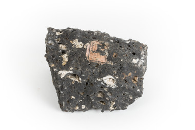
... geological survey... or in Victoria as part of programs of geological surveying undertaken... or in Victoria as part of programs of geological surveying undertaken ...Malachite is a green copper carbonate hydroxide mineral and was one of the first ores used to make copper metal. Malachite has been utilised as a gemstone and sculptural material in the past as its distinctive green color does not fade when exposed to light or after long periods of time. Malachite is formed at shallow depths in the ground, in the oxidizing zone above copper deposits. The material has also been used as a pigment for painting throughout history. Malachite is considered a rare gemstone in that the original deposits for the stones have been depleted leaving behind very few sources. In addition, the use of Malachite as gemstones and sculptural materials remains just as popular today as they were throughout history. It is quite common to cut the stone into beads for jewellery. The fact that Malachite has such a rich colour and one that does not fade with time or when exposed to light makes it particularly rare. Although there is no indication available of the locality from which the specimen was sourced, it is likely that the specimen was collected either in South Australia in the vicinity of the Burra Burra mines or in Victoria as part of programs of geological surveying undertaken in the Nineteenth and Twentieth centuries. This specimen is part of a larger collection of geological and mineral specimens collected from around Australia (and some parts of the world) and donated to the Burke Museum between 1868-1880. A large percentage of these specimens were collected in Victoria as part of the Geological Survey of Victoria that begun in 1852 (in response to the Gold Rush) to study and map the geology of Victoria. Collecting geological specimens was an important part of mapping and understanding the scientific makeup of the earth. Many of these specimens were sent to research and collecting organisations across Australia, including the Burke Museum, to educate and encourage further study.A solid hand-sized copper carbonate hydroxide mineral with quartz pebbles in red conglomorate matrix presenting shades of cream, brown and green.Existing label: Malachite / (green) in / conglomerate / (white quartz / pebbles / in red matrix /geological specimen, geology, geology collection, burke museum, beechworth, geological, indigo shire, malachite, malachite specimen, australian mines, mines, geological survey, conglomorate, matrix -
 The Beechworth Burke Museum
Geological specimen - North Queensland Agates, Unknown
... 1852 Geological Survey of Victoria... to the Geological Survey of Victoria. It was donated to the Museum in 1868... to the Geological Survey of Victoria. It was donated to the Museum in 1868 ...Agate occurs when amygdales (gas pockets) form in the upper levels of basaltic lava flows. If these pockets or bubbles are iniltrated by water bearing silica in solution, the fluid dries and hardens in layers, forming round or egg shaped nodules or geodes within the rocky matrix. Agate is formed of a silica mineral chalcedony similar to quartz. Although relatively common and semi-precious, agate has been prized since at least 1450 BC - an intricately carved agate seal was found in the 2015 excavation of a grave belonging to a Mycenaeum priest or warrior near Pylos in Greece. Agate is also used in jewellery and other decorative or ritual purposes due to its often striking appearance. These specimens originated in North Queensland, which contains noted agate-fossicking regions such as in the area surrounding Forsayth. They were collected in approximately 1852 as an adjunct to the Geological Survey of Victoria. It was donated to the Museum in 1868. Victoria and other regions of Australia were surveyed for sites of potential mineral wealth throughout the 19th Century. The identification of sites containing valuable commodities such as gold, iron ore and gemstones in a locality had the potential to shape the development and history of communities and industries in the area. The discovery of gold in Victoria, for instance, had a significant influence on the development of the area now known as 'the goldfields', including Beechworth; the city of Melbourne and Victoria as a whole. The specimens are significant as examples of surveying activity undertaken to assess and direct the development of the mineral resource industries in Victoria and Australia, as well as the movement to expand human knowledge of earth sciences such as mineralogy and geology in the nineteenth century. Two solid egg-sized pieces of peach/orange toned agate (a common semi-precious chalcedony, similar to quartz) with a striped pattern, embedded in a light and dark brown matrix. geological specimen, geology, geology collection, burke museum, beechworth, agate, north queensland agate, 1852 geological survey of victoria, l. hufer - donor, mineralogy, agate specimen, indigo shire -
 The Beechworth Burke Museum
Geological specimen - Sphalerite, Unknown
... geological survey..., in Broken Hill, NSW, as an adjunct to the Geological Survey..., in Broken Hill, NSW, as an adjunct to the Geological Survey ...Sphalerite or sphaelerite is named from the Greek word for 'treacherous' or 'deceiver' as specimens can vary widely in appearance, making them hard to visually identify. It is a zinc sulfide with the chemical composition (Zn,Fe)S, the most important ore of zinc. Specimens of sphalerite can contain iron as a substitute for up to 25% of the usual zinc present, as well as trace elements of gallium, cadmium, geranium and indium. Small amounts of arsenic and manganese may also be detected. Sphalerite is found in igneous, sedimentary and metamorphic rocks. It forms when carbonate rock encounters acidic, zinc-bearing fluid. It often forms in veins or in fissures of the existing rock, with colours and crystal shapes dependent on the composition of the the combining elements. It forms isometric crystal shapes including cubes, tetrahedrons, octahedrons, dodecahedrons. This specimen was collected in approximately 1852, in Broken Hill, NSW, as an adjunct to the Geological Survey of Victoria. It was donated to the Museum in 1868. Victoria and other regions of Australia were surveyed for sites of potential mineral wealth throughout the 19th Century. The identification of sites containing valuable commodities such as gold, iron ore and gemstones in a locality had the potential to shape the development and history of communities and industries in the area. The discovery of gold in Victoria, for instance, had a significant influence on the development of the area now known as 'the goldfields', including Beechworth; the city of Melbourne and Victoria as a whole.The specimen is significant as an examples of surveying activity undertaken to assess and direct the development of the mineral resource industries in Victoria and Australia, as well as the movement to expand human knowledge of earth sciences such as mineralogy and geology in the nineteenth century.A pipe-shaped specimen of sulfide-mineral zinc ore displaying patches of black, brown, beige and gold colouring. The main item has associated broken pieces. geological specimen, geology, geology collection, burke museum, beechworth, mineralogy, indigo shire, geological survey, sphalerite, sphaelerite, zinc ore, broken hill, nsw, victoria, galena, fluorite, chalcopyrite, lead, cadmium, gallium, germanium, indium, iron -
 Bendigo Historical Society Inc.
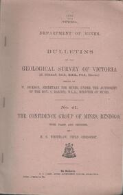
Book - MINING REPORTS - THE CONFIDENCE GROUP OF MINES BULLETIN NO 41
... Bulletins of the Geological Survey of Victoria...Light brown covered booklet 'Bulletins of the Geological... of Mines Bulletins of the Geological Survey of Victoria W Dickson ...Light brown covered booklet 'Bulletins of the Geological Survey of Victoria issued by W Dickson, Secretary for Mines, Under the Authority of the Hon. S Barnes M L A Minister of Mines. No 41 The Confidence Group of Mines, Bendigo with Plans and Sections by H S Whitelaw, Field Geologist, dated 1918. Mines mentioned are: Confidence Extended Mine, Confidence Tribute Company and the Central Windmill Hill Mine. Mentioned in the report are crushings and gold yield, details of levels, names of leases along the reef. Extracts from Mine Manager's Half-yearly Reports, 1878-1915 of tons crushed and gold yield. Plans and sections of the Confidence Extended Mine on the Garden Gully Line of Reefs are: Plate I General Plan of All Levels, Plans of Levels Plate No II, Plans of Levels Plate No III, Transverse Section Plate No IV, Longitudinal Section Plate No V, and Central Windmill Hill Mine Transverse Section Plate No VI. Plates signed by H S Whitelaw 17 & 18/6/16 and 20/7/16. Booklet if part of the Albert Richardson Collection. book, bendigo, mining reports, mining reports, the confidence group of mines bulletin no 41, confidence extended mine, confidence tribute company, central windmill hill mine, department of mines, bulletins of the geological survey of victoria, w dickson, the hon s barnes, h s whitelaw, h j green, mr robert eddy, mr w h cundy, j foster, c j thompson -
 The Beechworth Burke Museum
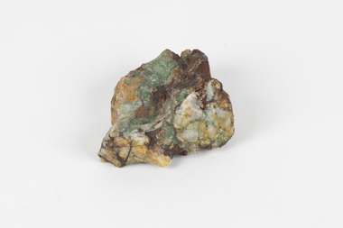
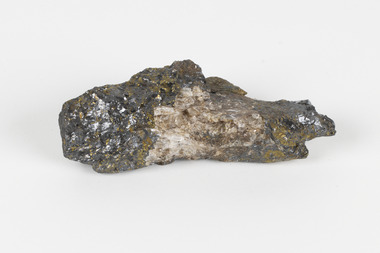
Geological specimen - Dolomite
... geological survey... as part of the Geological Survey of Victoria. It was donated... as part of the Geological Survey of Victoria. It was donated ...Dolomite is a mineral, calcium magnesium carbonate, with the chemical formula CaMg(CO3)2. It is a principle component of various rock types sometimes also referred to as dolomite, including dolostone, dolomitic marble and dolomitic limestone (according to the composition of each type). Dolomite rock is found in sedimentary basins throughout the world, comprising approximately 2% of the Earth's crust. It is formed when lime mud or limestone encounters groundwater containing magnesium. Dolomite can contain elements such as lead, zinc and copper. Dolomite and limestone are used in various construction, landscaping and agricultural processes. This specimen was donated to the Burke Museum in 1868 by Alfred Selwyn as part of the Geological Survey of Victoria. It was donated to the Museum in 1868. Victoria and other regions of Australia were surveyed for sites of potential mineral wealth throughout the 19th Century. The identification of sites containing valuable commodities such as gold, iron ore and gemstones in a locality had the potential to shape the development and history of communities and industries in the area. The discovery of gold in Victoria, for instance, had a significant influence on the development of the area now known as 'the goldfields', including Beechworth; the city of Melbourne and Victoria as a whole. Dolomite and limestone are mined at several locations in Victoria, including sites in the North-East of the state in Bindi and Limestone Creek. There are notable dolomite deposits in most Australian states. The dolomitised form of the mineral tends to come from older limestone deposits, formed during the palaeozoic era in marine settings, so this specimen may have come from a deposit located along a coastline in Victoria or another state. The specimen is significant as an example of surveying activity undertaken to assess and direct the development of the mineral resource industries in Victoria and Australia, as well as the movement to expand human knowledge of earth sciences such as mineralogy and geology in the nineteenth century. This specimen is part of a larger collection of geological and mineral specimens collected from around Australia (and some parts of the world) and donated to the Burke Museum between 1868-1880. A large percentage of these specimens were collected in Victoria as part of the Geological Survey of Victoria that begun in 1852 (in response to the Gold Rush) to study and map the geology of Victoria. Collecting geological specimens was an important part of mapping and understanding the scientific makeup of the earth. Many of these specimens were sent to research and collecting organisations across Australia, including the Burke Museum, to educate and encourage further study.Hand-sized piece of pale pink dolomite (calcium magnesium carbonate) with dark grey rim and hollowed centre. geological specimen, geology, geology collection, burke museum, beechworth, dolomite, mineralogy, geological survey, alfred selwyn, limestone, calcium magnesium carbonate -
Bendigo Historical Society Inc.
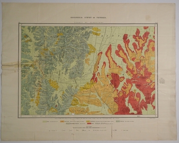
Map - GEOLOGICAL MAP OF BENDIGO GOLD FIELD
... of Geological Surveys, from surveys by H.S. Whitelaw, Fiield Geologist...H. Herman, Director of Geological Surveys, from surveys... of H. Herman, Director of Geological Surveys, from surveys ...Two framed laminated maps (a,b) of Bendigo goldfield reef lines, map (b) is a continuation of the reef lines in map (a). On map(a) written in black on top: 'Geological Map, Bendigo Gold Field', Scale of chains, anticlines, synclines, shafts, alluvial and contours marked. Map (b) is continuation of (a). Written on the bottom RH corner of map: 'Prepared in 1923 in the Bendigo Office Mines Department under the direction of H. Herman, Director of Geological Surveys, from surveys by H.S. Whitelaw, Fiield Geologist, assisted by E.S. Usher & J. J. Moore. Re-issued in 1936.'H. Herman, Director of Geological Surveys, from surveys by H.S. Whitelaw, Fiield Geologist, assisted by E.S. Usher & J. J. Moore. Re-issued in 1936.'bendigo, mining, geological map. -
 The Beechworth Burke Museum
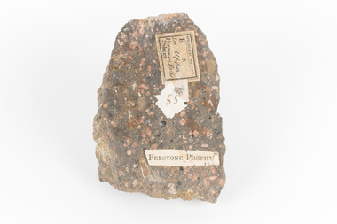
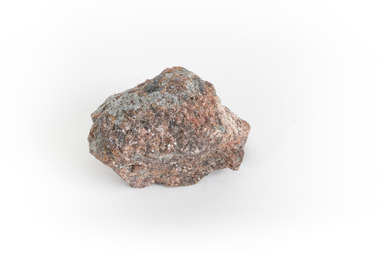
Geological specimen - Porphyritic Rhyodacite
... GEOLOGICAL SURVEY / R / S 55 FELSTONE PORPHY... collected in Victoria as part of the Geological Survey of Victoria ...This specimen was recovered from the Nigretta Falls (previously named the Upper Wannon Falls), Victoria. The falls are fed by the Wannon River that has its head waters in the Grampians mountains. Approx. 10km upstream of the Wannon Falls, Nigretta is a multi-channel segmented cascade of smaller drops and bounces guided by patterns of joints in a much older (Devonian) rhyolitic volcanic rock. Both the Wannon and Nigretta Falls are iconic landscape features, entrenched in the history and identity of the region. These falls are particularly rare as they are the product of volcanic activity, which is unique in the context of the Volcanic Plain of Victoria. Waterfalls of this capacity are generally associated with the Uplands areas of Victoria, rather than the edges of the Volcanic Plain. This specimen is part of a larger collection of geological and mineral specimens collected from around Australia (and some parts of the world) and donated to the Burke Museum between 1868-1880. A large percentage of these specimens were collected in Victoria as part of the Geological Survey of Victoria that begun in 1852 (in response to the Gold Rush) to study and map the geology of Victoria. Collecting geological specimens was an important part of mapping and understanding the scientific makeup of the earth. Many of these specimens were sent to research and collecting organisations across Australia, including the Burke Museum, to educate and encourage further study. A solid, dark grey mineral specimen with pale terracotta coloured inclusions. Rhyodacite is a volcanic rock intermediate in composition between dacite and rhyolite. Rhyodacites form from rapid cooling of lava relatively rich in silica and low in alkali metal oxides.GEOLOGICAL SURVEY / R / S 55 FELSTONE PORPHYburke museum, beechworth, indigo shire, beechworth museum, geological, geological specimen, porphyritic rhyodacite, lava, nigretta falls, upper wannon falls, dacite, rhyolite, volcanic geology -
 Bendigo Historical Society Inc.
Map - COUNTY OF GLADSTONE, November 1910
... Map: County of Gladstone, Geological survey of Victoria... Map: County of Gladstone, Geological survey of Victoria ...Map: County of Gladstone, Geological survey of Victoria. Geological mapmap, gladstone, geological, county of gladstone, geological map -
 Federation University Historical Collection
Book, Report on the Ballarat East Gold-Field, 1894 and Ballarat East Gold-Field, 1907, 1894
... Survey of Victoria and Professor of Geology at Melbourne... of the Geological Survey of Victoria. Photographs include Looking South... Survey of Victoria and Professor of Geology at Melbourne ...The Ballarat Ironworkers' and Polytechnic Association was at the Ballarat School of Mines. In 1907 J.W. Gregory Professor of Geology at Glasgow Univesity, Late Director of the geological Survey of Victoria and Professor of Geology at Melbourne University. W. Dickson was Secretary for Mines and Donald McLeod was the Minister of Mines. in 1894 Ernest Lidgey was the Assistant Geological Surveyor for the Victorian Department of Mines. A.W. Howitt was Secretary for Mines and Henry Foster was the Minister of Mines. Charcoal hard covered report on the Ballarat East Goldfield. The book combines two reports from the Victorian Department of Mines. The 1894 report is 52 pages and includes images and plans. The 1907 Report is number 4 in the Memoirs of the Geological Survey of Victoria. Photographs include Looking South from the Britannia Mullock Heap, View from Sovereign Hill, Golden Point gold discovery site.Stamped "Ballarat Ironworkers' Association School of Mines" Bookplate of the Ballarat Ironworkers' and Polytechnic Association. Written inside front cover: "S.J. Miller, 115 Ascot Street, Ballarat"ballarat ironworkers' and polytechnic association, ballarat school of mines, ironworkers, geology, mining, ballarat east, llanberris, victoria united mine, normanby, north woah hawp, bookplate, s.j. miller, library plate, golden point, gold discovery at golden point, new normanby mine, william baragwanath, new speedwell, britannia united, llanberris co, sulieman pasha, prince regent, dalzell-cum-prince regent, north prince extended, eastern star, f. gray, victoria united gold mine, sovereign hill mine, prince regent mine, britannia mine -
 The Beechworth Burke Museum
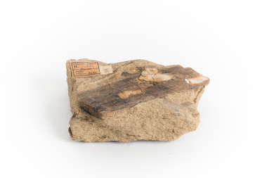
Geological specimen - Yellow Sandstone
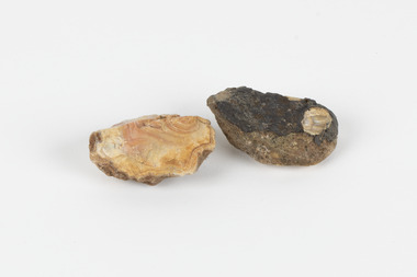
... Geological survey / R.... S 61 / Loc Bareboot Hills / Sheet... were collected in Victoria as part of the Geological Survey ...This specimen is from Barefoot Hills, Victoria. Sandstones are economically important as major reservoirs for both petroleum and water, as building materials, and as valuable sources of metallic ores. Most significantly, they are the single most useful sedimentary rock type for deciphering Earth history. This specimen is part of a larger collection of geological and mineral specimens collected from around Australia (and some parts of the world) and donated to the Burke Museum between 1868-1880. A large percentage of these specimens were collected in Victoria as part of the Geological Survey of Victoria that begun in 1852 (in response to the Gold Rush) to study and map the geology of Victoria. Collecting geological specimens was an important part of mapping and understanding the scientific makeup of the earth. Many of these specimens were sent to research and collecting organisations across Australia, including the Burke Museum, to educate and encourage further study.A sedimentary rock composed mostly of quartz sand. Sandstone is the second most common sedimentary rock after shale. Sandstones consist of sand-sized grains principally quartz, feldspar and rock fragments. The two major classes of sandstone are arenite and wacke. the colour of sandstone varies from grey, yellow, red and white reflecting the variation in mineral content and cement and is gritty to touch (like sandpaper).Geological survey / R.... S 61 / Loc Bareboot Hills / Sheet / 24SE / 94 /burke museum, beechworth, indigo shire, beechworth museum, geological, geological specimen, mineralogy, sandstone, yellow sandstone, victoria, barefoot hills -
 The Beechworth Burke Museum
Geological specimen - Loellingite in Rhodonite
... geological survey of victoria... collected in Victoria as part of the Geological Survey of Victoria ...Rhodonite is a reddish-pink manganese silicate material and often contains iron, magnesium and calcium. It is usually found in metamorphic rocks (rocks which have been altered by heat, pressure or chemical process). It can range in size from tiny to massive. Because of their composition they are not suitable for use in jewellery because they are hard enough. It is quite rare to find, though has been found in Australia, North America, South America and Europe.This specimen is part of a larger collection of geological and mineral specimens collected from around Australia (and some parts of the world) and donated to the Burke Museum between 1868-1880. A large percentage of these specimens were collected in Victoria as part of the Geological Survey of Victoria that begun in 1852 (in response to the Gold Rush) to study and map the geology of Victoria. Collecting geological specimens was an important part of mapping and understanding the scientific makeup of the earth. Many of these specimens were sent to research and collecting organisations across Australia, including the Burke Museum, to educate and encourage further study. This specimen is a palm shaped piece of loellingite within rhodonite. It is mostly reddish-pink coloured, with flecks of light and dark grey. Loellingite is a grey iron arsenide which often forms into crystal shapes. It is mostly found in mesothermal veins (caused by immense heat) with sulfides or in limestone. It is toxic when heated or struck. rhodonite, loellingite, burke museum, beechworth, geological survey of victoria