Showing 206 items
matching holloways
-
 Eltham District Historical Society Inc
Photograph, Liz Pidgeon, Heritage Excursion; The 1901 Eltham Railway Walk, 3 May 2014
Newsletter No. 216, May 2014 May Excursion – The 1901 Eltham Railway Walk The railway from Heidelberg to Eltham was opened in 1902. Over the previous year railway construction cut a curving swathe through Josiah Holloway’s 1851 Little Eltham subdivision. The survey plans for the railway show the owners and occupiers of land within Little Eltham affected by the railway alignment and for some distance each side. The plans show houses and other buildings but development at that time was rather sparse. Copies of these plans from the State Library of Victoria collection have been provided to the Society by Alan Sheehan. For our walk on 3rd May we intend to follow the railway from the Eltham Station to Ryans Road, which was the boundary of the adjoining Montmorency Farm. The return will be by way of nearby streets. Along the way we will discuss the details shown on the railway plans as well as more recent railway documents and photographs. At the conclusion and if time permits we can inspect the historical display at the Eltham Station. The walk is about 3 km in length and will take about 2.5 hours. It will start at 2 pm at the Eltham Railway Station car park (east/Main Road side) (Melway Ref. 21 J5).Born Digitalheritage excursion, activities, eltham district historical society, eltham railway station, eltham library, trestle bridge -
 Geoffrey Kaye Museum of Anaesthetic History
Equipment - Inhaler, Hewitt, George Barth & Co. Ltd, c. 1895
Sir Frederic W. Hewitt (1857-1916), an accomplished and well respected English anesthesiologist, was an expert in the function and use of the Clover Ether Inhaler. In 1901, Hewitt described his modification of the Clover Inhaler. Often referred to as the Hewitt Wide-Bore Inhaler, Dr. Hewitt introduced changes in order to make it easier to breathe through the device and improve the ventilation of oxygen and carbon dioxide. In 1901, Hewitt was recruited to anesthetize King Edward VII for emergency abdominal surgery. This was just a day or so before the new King was to be coronated. He recovered well, and Hewitt became the first anesthesiologist ever to be knighted. (Source: Wood Library Museum)Tall black round topped box with brass hooks at the sides and brass hinges at rear. There is a brown fabric handle on the top. The box has red padding inside the lid and red lining inside the base and sides. There is a round section in the base of the box for holding the round clear glass bottle for ether. There is also a ellipse-shaped metal inhaler on small metal base with a thin metal handle and pipe with bakelite plug attached via a small metal chain. A brown mask is made of brown leather and celluloid which is connected to the inhaler. There is a metal ether measure for pouring the ether.On notecard in box: (B) HEWITT'S INHALER 1895, MADE BY GEO. BARTH & CO LTD., ADVERTISED AS THE SOLE MAKERS OF THE INHALER AND RECOGNISED BY HEWITT IN HIS TEXT BOOK - ANAESTHETICS AND THEIR ADMINISTRATION - AS THE MAKER OF HIS INHALER. / GIVEN BY DR. E.S. HOLLOWAY IN 1951, WHO ACQUIRED MUCH OF HOWARD JONES' EQUIPMENT AFTER THE LATTER'S DEATH. Stamped on underside of glass bottle in a circle: WUBW [illegible] Blue sticker on inhaler: O.2.13. Printed on inhaler under handle: Geo Barth [illegible] / SOL [illegible] Printed on body of inhaler: Full Printed on body of inhaler: 1/2 Printed on inside of leather mask: F35hewitt, sir frederic, jones, howard, inhaler, geo. barth & co. ltd., ether -
 Eltham District Historical Society Inc
Photograph, Liz Pidgeon, Heritage Excursion; The 1901 Eltham Railway Walk, 3 May 2014
Football match at Eltham Central Park between Eltham and Heidelberg Newsletter No. 216, May 2014 May Excursion – The 1901 Eltham Railway Walk The railway from Heidelberg to Eltham was opened in 1902. Over the previous year railway construction cut a curving swathe through Josiah Holloway’s 1851 Little Eltham subdivision. The survey plans for the railway show the owners and occupiers of land within Little Eltham affected by the railway alignment and for some distance each side. The plans show houses and other buildings but development at that time was rather sparse. Copies of these plans from the State Library of Victoria collection have been provided to the Society by Alan Sheehan. For our walk on 3rd May we intend to follow the railway from the Eltham Station to Ryans Road, which was the boundary of the adjoining Montmorency Farm. The return will be by way of nearby streets. Along the way we will discuss the details shown on the railway plans as well as more recent railway documents and photographs. At the conclusion and if time permits we can inspect the historical display at the Eltham Station. The walk is about 3 km in length and will take about 2.5 hours. It will start at 2 pm at the Eltham Railway Station car park (east/Main Road side) (Melway Ref. 21 J5).Born Digitalheritage excursion, activities, eltham district historical society, eltham railway station, eltham library, trestle bridge, eltham central park, football -
 Eltham District Historical Society Inc
Photograph, Liz Pidgeon, Heritage Excursion; The 1901 Eltham Railway Walk, 3 May 2014
EDHS Member Doug Orford stands by a yarn bombing installation. ewsletter No. 216, May 2014 May Excursion – The 1901 Eltham Railway Walk The railway from Heidelberg to Eltham was opened in 1902. Over the previous year railway construction cut a curving swathe through Josiah Holloway’s 1851 Little Eltham subdivision. The survey plans for the railway show the owners and occupiers of land within Little Eltham affected by the railway alignment and for some distance each side. The plans show houses and other buildings but development at that time was rather sparse. Copies of these plans from the State Library of Victoria collection have been provided to the Society by Alan Sheehan. For our walk on 3rd May we intend to follow the railway from the Eltham Station to Ryans Road, which was the boundary of the adjoining Montmorency Farm. The return will be by way of nearby streets. Along the way we will discuss the details shown on the railway plans as well as more recent railway documents and photographs. At the conclusion and if time permits we can inspect the historical display at the Eltham Station. The walk is about 3 km in length and will take about 2.5 hours. It will start at 2 pm at the Eltham Railway Station car park (east/Main Road side) (Melway Ref. 21 J5).Born Digitalheritage excursion, activities, eltham district historical society, eltham railway station, eltham library, trestle bridge, yarn bombing, doug orford -
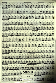 Federation University Historical Collection
Poster, Ballarat School of Mines Staff, 1995
The Ballarat School of Mines is a predecessor institution of Federation University Austraila.An A2 poster showing small black and white portraits of each staffmember at the Ballarat School of Mines. Names include: Curriculum Services - John Kemp, Roger McFarlane, Leanne Gingell, Sandra Glover, Doug Seymour. Human Resources - Ross Furness, Ian Pym, Jenny Gough, Julie Thomas. Planning/Marketing - Keith Boast, Simone Byrne Student Services - Brian Webber, Janet McGie, Jani White, Jan Harwood, Judy Mills, Kirsten Martin, Barrie Frith, Tania Gaunt, Pam Merrett, Heather Durrant, Jola Piskozub, Frances Ratcliffe, Ian Robinson, Merill Potter, Lorelli Huggins, Maureen Auchettl, Fiona Angus, Natalie Howard. Corporate Services - Graham Penhall, Phil Dixon, Ron Sutton, Ron Lucas, Robert Munt, Garry Christie, Don Lawless, Bernie Stevens, David Fithall, Rebeccah Parker, Craig Holloway. Ararat Campus - David Haddow, Kim Knight, Kevin Martin, Maureen Green, Ian Harris, Adrian McMillan, Frank Parker, Keith Akers. Rural Studies - Andrew Sullivan, Gary Lyttle, Ian Best, Graham Shearer, Malcolm Trainer, Ross Holton, Anthony Thake, Paul Norquay, John Harrison. ballarat school of mines, staff, ron wild, max palmer, heather durant, vl d'angri, alistair heighway, neville french -
 Bendigo Historical Society Inc.
Document - CONNELLY, TATCHELL, DUNLOP COLLECTION: LEGAL PAPERS, 1886
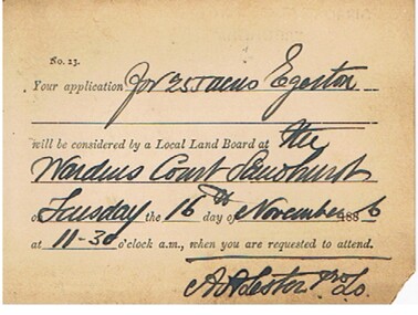
Documents. Connelly, Tatchell & Dunlop - Legal Papers. 1 - 1886 - Letter from Meudell George D re Holloway. Letterhead - Horrell & Meudell (R F Horrell & G D Meudell), Auditors, Secretaries and Accountants, 10 Market Buildings, William Street, Melbourne. 2 - 1886 - Post Office Telegraph 4 Nov 1886 for Merrifield S from Bruce T?, St Kilda asking, 'Where is Penders blackboy Pompey'. Reply from Merrifield mentions 'Pompey was remanded Melbourne on Friday last. Enquire at watch tower there.' Also mentions 'I don't know whether Mr Bruce is Pompey's friend or Caesars (Mr Penders)' on Attached handwritten note dated 4 Nov 1886. 3 - 1886 - Letter from Williams A M, Solicitor, 28 Queen Street, Melbourne re Bagot? V Budden 4 - 1886 - Post card to Suffern? Mr William James, Elmore from Lester A,A. Land Officer, re 255 acres, Egerton. Mentions Wardens Court, Sandhurst. 5 - 1886 - Letter from Drues W T, 19 Temple Court re A'Becketts fees. 6 - 1886 - Letter from Barrett Henry, Runnymede East.cottage, miners, connelly, tatchell & dunlop, meudell george d, holloway, horrell & meudell, merrifield s, bruce t?, penders, pompey, caesars, williams a m, bagot, budden, suffern mr william james, lester a a, drues w t, a'becketts, barrett henry -
 Eltham District Historical Society Inc
Photograph, View at Eltham, Vic, c.1924
Copy of possible Rose Stereograph Co. postcard “View at Eltham, Vic.”, c.1924 looking southwest from Main Road near York Street to Bridge Street and the original 1875 bridge across what is now the Alistair Knox Park The land in the foreground was first bought from the Crown by J.M. Holloway in 1851. The land was sub-divided and called "Little Eltham". Bridge Street was created as part of the sub-division. Most of the sub-division was residential lots but the creek valley was divided into lots for small farms. Council started to buy the land for the Eltham Town park in the early 1960s. The area was used as a garbage tip and filled above the flood plain of the creek. Development of the land for a park began in the early 1970s. The house on the right was owned for many years by the Hill family until Council bought it in the early 1960s. The house was built in the 1850s or 60s. The house on the left stood on what is now the southwest corner of Susan and Bridge Streets. The Braithwaite family was associated with this house. The double line of fencing in the foreground was a continuation of York Street to the creek. The Bridge Street bridge was built in 1875 and replaced in 1958. (Ref: Early view of Little Eltham; Byways of History by Colleen Ison, Publication unk, 24 August 1982) Reproduced on p61 of 'Pioneers & Painters' Date estimated on same as View at Hurstbridge featuring Wattle Valley EstateThis photo forms part of a collection of photographs gathered by the Shire of Eltham for their centenary project book,"Pioneers and Painters: 100 years of the Shire of Eltham" by Alan Marshall (1971). The collection of over 500 images is held in partnership between Eltham District Historical Society and Yarra Plenty Regional Library (Eltham Library) and is now formally known as the 'The Shire of Eltham Pioneers Photograph Collection.' It is significant in being the first community sourced collection representing the places and people of the Shire's first one hundred years.Digital image 120 format B&W negative Prints 17 x 25 cm and 10 x 15 cmsepp, shire of eltham pioneers photograph collection, eltham, bridge street, bridge, alistair knox park, braithwaite, bridge street bridge, eltham town park, hill family home, main road, pioneers and painters, york street -
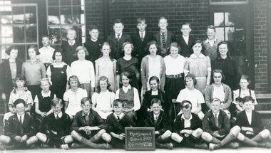 Ringwood and District Historical Society
Photograph, Ringwood State School - Class photograph- Grade 7 & 8, 1937
Black and white photograph - Grade 7 & 8, 1937"Attached to photograph" Back Row - L to R: Don Sorrenson, Bruce Williamson, Gus Horne, Jeff Lang, Ken Paternoster, Alan Mayers, ?, ?. 2nd Row -- L to R: Joyce Fraser, Josie Roberts, Vivienne Martin, Winnie Wilkins, Beulah Crouch, ?, Joyce Read, Fay Paternoster, Joyce Sanders, Betty Washusen. 3rd Row - L to R: Mary Stevenson, Elsie Beaumont, Hazel Payne, Dianne Holloway, Elsie Dawson, Helen Russell, Betty Baner, Nancy Izard, Maryb Beilby. Front Row - L to R: Ken Ansell, Frank Beaumont, Stan Beal, Peter McDonald, Rodney Dickson, Ray Minahan, Ron Mathews, Ian Jackson. Teacher: -
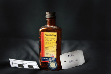 City of Moorabbin Historical Society (Operating the Box Cottage Museum)
Manufactured Glass, brown bottle 'Campholine', c1950
Sigma was founded by two Melbourne pharmacists in 1912, it has grown to become one of the key players in Australia’s pharmacy industry .Edwin Thomas Church (1864 – 1947) and Ernest Holloway Leete a prominent chemist and a member of the College of Pharmacy who had established his own pharmacy in 1897. The entrepreneurial Leete had been part of a move in 1904 among a group of commercially-minded chemists to put up proprietary preparations. 1913 - 1927 Initially, the fortunes of the Sigma enterprise relied on E. H. Leete ‘working from home’, and even as late as 1915 company address was in Claremont Avenue Malvern. Following the establishment of the business in 1912, the Sigma Company Limited was located at Flinders Lane, Melbourne. Sigma – Tromax, 1928 E.H. Leete after sixteen years, said he would not stand again as a director of the company because interests were also turning elsewhere. He was assisting another company as its agent in the motor trade. 1938 to1953 was characterised by steady growth for Sigma, accelerated by manufacturing opportunities during World War Two. Between 1975 and 1996 the company was transformed as it entered a period of both consolidation and rapid growth. The appointment, in 1996, of new Managing Director, George Savvides, marked a break from the past. Today Sigma is a leading full line wholesale and distribution business to pharmacy. Sigma is also the owner of some of Australia’s best known pharmacy brands in Amcal, Guardian and Amcal MaxA triangular shaped, brown glass, bottle with a metal screw top containing ‘Campholine’Front label : Campholine / Camphorated / Mineral Oil / CAUTION ! / Use strictly in accordance / with the directions / Adults : Rub briskly on parts affected . Infants ; Use gentle massage . / 20z. / TROMAX / SIGMA CO. Ltd. / MELBOURNE / Label Sticker : ROBERTSON OF ELSTERNWICK 1/ 8 pharmacy, medicines, campholine, glassware, bottles, moorabbin, bentleigh, cheltenham, melbourne, tromax-sigma co ltd, leete ernest, church edwin, sigma company pty ltd -
 Eltham District Historical Society Inc
Audio Recording, Audio Recording; 2018-06-13 Jim Connor and the history of the former Shire of Eltham office site, 13 Jun 2018
June Meeting (Newsletter No. 240, Jun. 2018) Prior to Shillinglaw Cottage (c1878-80) being relocated to where it is now operated as a popular cafe near the Eltham Library, it was within Josiah Holloway’s 1850s subdivision known as Little Eltham, which later became the centre of the first Eltham township. Originally a farmer’s cottage it is historically significant because it is one of the Shire’s oldest dwellings and a fine example of the work of the well-known pioneer builder George Stebbing. In 1964 the then Shire of Eltham purchased the Shillinglaw property with the intention of demolishing the cottage and constructing new Shire offices on the site. However extensive community action resulted in funds being raised to have the building saved and relocated further south to the Eltham Common, where it was joined by the Eltham Library 1994. New Shire offices opened in 1965, but following municipal restructure in 1994 these were demolished and the land sold to a developer, which precipitated a dramatic trail of community angst, threats of legal action, the sacking of a newly elected council and several unsuccessful development proposals, by subsequent councils. After all these years the vacant site there is still guarded by the three trees that were outside the front of the Shillinglaw Cottage. At our Society meeting on Wednesday 13th June 2018 Jim Connor will speak about the dramatic tale encompassing the history of the former Eltham Shire office site and the adjoining War Memorial Buildings complex, which are now being considered for sale or redevelopment by the current Nillumbik Shire Council.1:17:57 duration Digital MP3 File 27 MB audio recording, eltham district historical society, jim connor, meeting, shire of eltham office site, society meeting -
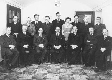 Ringwood and District Historical Society
Photograph, Ringwood Councillors and Staff - 1948 or 1949
Typed below photograph, "Ringwood Councillors and Staff - 1948" on one copy. Other copy lists those in photograph and dates the photograph as 1949. Inscription reads, "Ringwood Councillors & Staff, August, 1949. Front row L-R. Mr. A.F.B. Long (Town Clerk) Cr. F. Corr, Cr. B. Hubbard, Cr. H.C. Pearson (Mayor), Cr. E. Stewart, Cr. H.E. Parker, Cr. W. Wademan.Back Row - J. Proudley (Caretaker), L.C. Steeth (Ranger), S.R. Taylor (Health Inspector), G. Holloway (Clerk), A.C. Robertson (Eng. Asst.), Miss A. Goldie (Typist), C. Cox (Cadet Eng.), C. Merry (Building Inspector), F.R. Lucas (Engineer)" -
 City of Moorabbin Historical Society (Operating the Box Cottage Museum)
Photographs,x3 Colour Early Weatherboard Cottage Cheltenham c1880, 1981
Henry Dendy , a farmer from Sussex England, purchased 5,120 acres of land in the area of a 'Special Survey 1841' that extended from Brighton bayside North Road, East Boundary Rd to South Road. This area became known as Dendy's Brighton and as part of the sale 139 emigrant workers arrived in 1842 however Dendy was unable to find work and lodgings for these people. J.B.Were, financier took over the management of the 'Special Survey 1841' area and began to sell and lease allotments. 1850 the Squatter King brothers sold land south of Dendy's 'Special Survey 1841' to Josiah Holloway who sectioned it into 2 acre lots @ £10 each for market gardens - 'Two Acre Village' and Charles Whorral opened a small hotel - 'The Cheltenham Inn' on the main Road - Arthur's Seat Rd, later Point Nepean Rd, now Nepean Highway. Notable settlers who moved into the area were Keys, Charman, Bruton, Le Page, Fairlam, Meeres and 1862 saw the separation from Brighton and the formation of the Mooorabbin Roads Board District. .By 1879 1000settlers were living in 'Cheltenham' serviced by a Post Office with Bank, Mechanics Institute, State School No 84,Keys Hotel, Meeres Store, Sir Thomas Bent ensured the new Railway Line from Caulfield to Mordialloc went through his constituency of Cheltenham 1881 and this changed the development to the bayside area of Cheltenham away from the 'Two Acre Village ' side causing some dissention, However Cheltenham as whole prospered and this house in Pine St is typical of the cottages built c 1890- 1900 in the area. This weatherboard house c 1890-1900 in Pine St Cheltenham is typical of those built for early settler families. Photo taken 1981 by CMHS member 3 x Colour photographs of an early c 1900 weatherboard house in Pine St Cheltenham taken by CMHS member 1981Kodak Aug. 81 / Handwritten Pine St Cheltenhamkeys robert, holloway josiah, king brothers, smith j l; smith mary ann, stanley helen, chaff cutter, horse drawn carts, toll gates brighton, motor cars 1900, steam engines, early settlers, bentleigh, parish of moorabbin, city of moorabbin, county of bourke, moorabbin roads board, shire of moorabbin, henry dendy's special survey 1841, were j.b.; bent thomas, o'shannassy john, king richard, charman stephen, highett william, ormond francis, maynard dennis, market gardeners, vineyards, orchards -
 Eltham District Historical Society Inc
Photograph - Colour Print, Belle Vue, Livingstone Road, Eltham, c.2015
Belle Vue property in Livingstone Road, Eltham was once owned by Society member Jo McCormick. Jo was a valued member of our committee and dear friend of many of our members until her death in 2009. Belle Vue is the farmhouse of a property that is now a significant part of suburban Eltham, just a short distance north of the town centre. Originally purchased by pioneer Eltham farmer Henry Stooke, the present-day old farmhouse sits within an extensive suburban residential area. The history of the property is largely based on a heritage assessment prepared by consultant Lorraine Huddle for Nillumbik Shire Council. Additional information from our Society records reveals Belle Vue farm comprised about 56 ha (140 acres) extending northerly from the northern boundary of Holloway’s 1851 Little Eltham subdivision. On the present day map the southern boundary was just north of Elsa Court and Grove Street. The western boundary was the Diamond Creek and extended northerly to Main Road where it turns easterly towards Research. It was traversed by the main road to Kangaroo Ground and beyond and from 1912 by the railway to Hurstbridge. From 1895 the farm was owned by William Williams and his wife Mary Ann. In 1914 -15 they built a new house now known as Belle Vue. They sold the land in 1920 and residential subdivision began soon after that. Belle Vue remains today on a substantially subdivided and very much reduced size residential lot in Livingstone Road. The house and many old trees on the site were subject to a heritage overlay under the Nillumbik Planning Scheme. Despite that overlay, the development and subdivision of the original land resulted in most of the heritage listed trees being removed. belle vue, eltham, livingstone road -
 Eltham District Historical Society Inc
Slide - Photograph, Eltham Town Park, c.May 1988
In 1981 the Shire of Eltham Historical Society was asked by the Victorian Place Names Committee to comment on a proposal by the Shire of Eltham to assign names to parklands in Eltham as follows:- "Eltham Common" - the area between the municipal offices, Main Road, the Eltham railway -line, and Panther Place and containing Shillinglaw Cottage. The Shire has advised that this name has been used locally for the site since about 1975. "Alistair Knox Park" - the area bounded by the Eltham railway -line, Panther Place, Main Road, Bridge Street, and Susan Street, and through which flows the Diamond Creek. The area has been known locally as "Eltham Town Park" The proposed name "Alistair Knox Park" had created some local controversy with a number of reversals of the Council's decision and letters to the local paper both for and against the proposal. The society was reluctant to be drawn into this controversy particularly as there were known to be members with strong views both for and against the proposed name. The society appreciated the work done by Alistair Knox both in the formulation of the park concept and in its development but because of the controversy generated by the proposed naming and also because of the wide general use of the park by the public·, the name Eltham Town Park was felt more appropriate. The society noted that there was no outstanding historical associations with the land comprising the park which would warrant naming the park after any particular person, place or event. No objection was raised to the Eltham Common proposal as set-out above. The decision was made in the knowledge that Alistair Knox had been associated with the society over many years and was a prominent figure in the recent history of Eltham. He was regarded as a key figure in the environmental building movement and in particular was renowned for his use of mud bricks as a building material. He served as a councillor of the Shire of Eltham from 1971-1975, his final year as Shire President. It was during these years that the proposals to create the park in its present form were shaped and Alistair played a leading part in the decision to make it a landscaped passive recreational park rather than a sporting area. The parklands comprise a section of the Diamond Creek valley. The creek itself flows through the centre of the area which is overlooked by steep hills on each side. The parks form part of the land purchased from the Crown in 1851 by J.M. Holloway and then subdivided into allotments and called "Little Eltham". While most of the area was subdivided into residential lots the creek valley was subdivided into lots suitable for small farms. Some further subdivision took place over the years and the whole of the parks now comprises eight separate titles. A list of some of the former owners has been compiled but exhaustive research on all owners has not been carried out. The ownership of one parcel has been traced back to when it was purchased from Holloway by John Hicks Petty in 1874, long after it was subdivided. Other families owning land within the area over the years included Lyon, Rees, Clark, Waterfall, Carrucan, Graham, Hill and Morant. The character of the valley area has remained rural while development occurred on each side. Early photos show the area as orchard and grazing land. In 1901 the railway was constructed through the area resulting in the timber trestle bridge across the Diamond Creek. which is an important feature of the park landscape. A memorial obelisk to the Eltham servicemen killed in World War 1 was erected at the south eastern corner of the park. The site is now within the intersection of Main Road and Bridge Street and the memorial was shifted in the 1950s to the Eltham R.S.L. clubrooms. Following the financial failure of the local sub-branch, the memorial obelisk was again relocated to the Eltham War Memorial building precinct in 2011. During the early 1960's the Council started purchasing the land which now comprises the parks. In the late 1960's the area to the east of the Diamond Creek was used as a garbage tip and filled above the flood plain of the creek. When this area was filled the tip was transferred to the west side of the creek. From the early 1970's the area has been progressively developed as a park for passive recreation with ornamental lakes, extensive tree planting and landscaping. The character of the valley before the days of the tip has been recreated and this has earned a Landscape classification from the National Trust, an unusual honour for a man-made landscape. The parks are not only attractive in appearance. The large number of people using them, particularly at weekends and holidays is evidence of their popularity and the foresight and careful planning of local residents, Councillors and Council Staff. 35mm colour positive transparency (1 of 23) Mount - Kodak EktachromeProcess Date MAY 88Meltham, main road, alistair knox park, eltham town park -
 Eltham District Historical Society Inc
Photograph - Digital Photograph, Jim Connor, Edendale Farm Homestead, 11 December 2014
Edendale Farm is Nillumbik Shire Council's environment centre situated in Gastons Road, Eltham between the railway and the Diamond Creek. The homestead on the property was built in 1896 and is of historical significance, being the subject of a Heritage Overlay under the Nillumbik Planning Scheme. The Edendale property was originally part of an extensive land purchase in 1852 from the Crown by pioneer Eltham farmer Henry Stooke. He initially purchased 51 acres and later expanded his holdings by purchasing another three adjacent Crown allotments extending northerly from Josiah Holloway's Little Eltham subdivision. Despite clearing the land, Stooke did not build on this property, choosing to live on his property "Rosehill" at Lower Plenty. In 1896 Thomas Cool, Club Manager of the Victoria Coffee Palace in Melbourne purchased 7 acres of the original Stooke land and built the house now known as Edendale. Cool did not farm the land, instead using it as a gentleman’s residence, retiring to Eltham at weekends. In 1918 he purchased an additional 7 acres but in 1919 he sold the property. Later owners included J.W. Cox, the Gaston family and D. Mummery. In the 1980s the Eltham Shire Council purchased the site for use as a Council depot, but this use did not proceed. Subsequently, it was used as the Council pound. The Edendale Farm Pet Education and Retention Centre was established in the summer of 1988/1989 and was set up to replace the existing dog kennels with a high standard pet retention centre. The design style of the building was established to compliment the features of the existing house. It was equipped with 10 retention pens, a veterinary room and a pet education area where school children and other interested parties learnt about pet care procedures. It was later developed into a community farm and was run by an advisory committee and in 2000 it became an Environment Centre. In early 2006 an advisory committee was established for the development of a master plan for future development at Edendale Farm. The committee included Russell Yeoman, a former long-time shire planner and founding member of the Eltham District Historical Society. At the time of filming the Master Plan and future for Edendale was about continuing to develop Edendale as a centre of environment learning and looking at expanding displays and school program, running a lot more of life-long learning and workshops around sustainable living.jim connor collection, edendale community farm, edendale farm, eltham, gastons road