Showing 104 items
matching la trobe st
-
 Ballarat Heritage Services
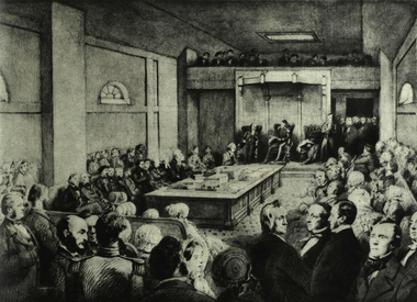
Photograph - Image, First Legislative Council of Victoria, 1851, 1851
Black and white image of the first Legislatie Council of Victoria on 03 November 1851. Leading citizens attended the inauguration by Governor La Trobe. The meeting was held at St Patrick's Hall, oOurke Street West, Melbourne. governor la trobe, parliament, legislative council of victoria -
 Melbourne Tram Museum
Postcard, La Trobe Collection, State Library of Victoria, Cable tram display at Box Hill, c1980
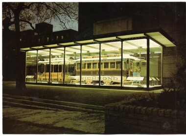
Postcard - black and white reproduction of a wall poster used by the Box Hill - Doncaster Tramway, includes sketch of Doncaster Tower, one of the tram cars and timetable. See Reg Item 699 and 198. Printed for the State Library of Victoria, by John Sands - Number PC11. Divided back, caption, printing information and bar code where a stamp would go. Robert Green advised by email 20-1-2018: "The tram in Russell Street was unveiled by the Premier, R J Hamer, on 1 May 1975. The ceremony was attended by F R Kirby, the Chairman of the M&MTB, and the Chairman (Judge Leckie) and Director (R H Fowler) of the Science Museum of Victoria." The tram was removed from the glass case when further development to the buildings occurred and temporarily relocated to Box Hill for the centenary of the Doncaster Tramway. 2nd copy of postcard - on rear - Has 33 cent stamp, postmarked for the Centenary of Cable Car Services, 11/11/1985 with a grip included and stamped "100 years of Melbourne trams carried on Commemorative official trip from Flinders St, Melbourne to Richmond Town Hall, November 11, 1985" in blue ink in the top left hand corner.trams, tramways, box hill, posters, timetables, doncaster, postcards, cable trams -
 Melbourne Tram Museum
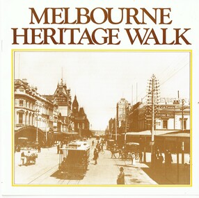
Pamphlet, Photo story Pty Ltd, "Melbourne Heritage Walk", 1985
Pamphlet or small book - 16 pages, centre stapled, printed in sepia colour - titled "Melbourne Heritage Walk" published for Victoria's 150th anniversary in 1985. Features a message from the Lord Mayor, map showing various walks and photographs of street scenes around the central Melbourne area along with heritage notes. Has a list of interesting places to visit. Related to a list of panels that had been provided at the time around the city. Published by Photo story Pty Ltd, Port Melbourne with photos from the RHSV, La Trobe Library, Mitchell Library and sponsored by the Australian Oil Industry.trams, tramways, melbourne, heritage, collins st, swanston st, bourke st, flinders st, russell st -
 Melbourne Tram Museum
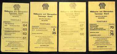
Ephemera - Timetables - MMTB trams - set of 8, Melbourne & Metropolitan Tramways Board (MMTB), 1976
Timetables - provide information on ticketing, fares, and timing points, with a description of the route and a map. Not all services had been allocated a route number at the time. 1 - East Brighton - City and via William St - routes 64, 65, 62 and 61 - July 1976 2 - Malvern (Burke Rd) to City and via Wiliam St - routes 5 and 35 - Oct. 1976 3 - Carnegie - City and via William St - routes 67, 37, and 66 - July 1976 4 - Wattle Parke - City and Camberwell depot - routes 70, 71 and 76 - Sept. 1976 5 - Kew - Cotham Road to St Kilda Beach - route 69 - August 1976 6 - East Preston - via Bourke or La Trobe, and East Brunswick - routes 88, 14, 89. 90, 96, 95, and 97 - Feb. 1976 7 - Toorak - City and via William St - routes 8 and 38 - August 1976 8 - St Kilda Beach and South Melbourne Beach and via William St - routes 15, 16, 53, 55, 1, 2 and 4 - Sept. 1976 Yields information about MMTB tram services during the 1970s. Set of 8 MMTB tram timetables - multifolded printed on yellow paper.timetable, mmtb, wattle park, east brighton, malvern, carnegie, kew, east brunswick, toorak, st kilda beach, south melbourne beach, route 64, route 65, route 62, route 61, roure 5, route 35, route 67, route 37, route 66, route 70, route 71, route 76, route 69, route 88, route 96, route 8, route 38, route 15, route 1, route 2, route 55, route 53 -
 Melbourne Tram Museum
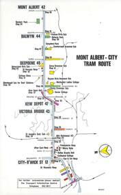
Map, Melbourne & Metropolitan Tramways Board (MMTB), Set of 15 tram route maps, 1977 to 1979
Series of 15 colour route maps for various tram lines or groups of tram lines for the MMTB. Some have the Transport Information Centre telephone printed on them, others have a label stuck on. Some are finished with a plastic laminate finish on either one or both sides. Show the major cross streets, parks, schools, other tram routes, major stop numbers and railway lines. Two copies of each held unless noted otherwise. .1 - Mont - Albert City - R11/77, shows routes 43. 47. 45. 44 .2 - Malvern, East Malvern, Carnegie and East Brighton Tram Routes (from St Kilda Junction) - R1/79 - shows routes 5, 3, 67, 66, 61, 62 and 64. .3 - Swanston St tram guide - R1/79 - lists all routes and route numbers that branch or cross Swanston St between Grattan St and St Kilda Junction. .4 - St Kilda Rd Tram Routes R12/77 - details South Melbourne Beach, route 1 and route 2 and St Kilda Beach routes 15, 16 and 55 otherwise shows were the various routes branch off St Kilda Road. Copy 1 has "P14909" in pencil in the bottom right hand corner. .5 - Kew - St Kilda Beach - R1/79 - Route 69. .6 - Footscray - Moonee Ponds - R3/81 - Route 82 .7 - Flinders St tram routes - R5/78 - North Balwyn, East Burwood, routes 48, 40, 41, Hartwell, 28, 74 and 75 .8 - William St tram routes - Route 55, 56 and 63 - South Melbourne Depot and Domain. copy 2 has "P14913" in bottom right hand corner. .9 - Toorak Camberwell and Glen Iris tram routes with Camberwell Junction and Malvern Town Hall, R1/79, routes 8, 7, 6, 72 and 73 shown. .10 - Swanston St tram routes - R12/77 - shows all the Swanston St routes, including East Coburg and Moreland. .11 - Bourke St tram routes - R4/77 - East Brunswick Blyth St and East Preston Tyler St and intermediate routes, routes 95, 96, 97, 90, 89 and 88. .12 - as for .11, dated 1/85, showing extension to La Trobe University - has Metropolitan Transit logo. Only 1 copy held. Also shows route 92 and 87. .13 - Batman Ave tram routes - R9/77 - Wattle Park, North Richmond and Prahran - routes 70, 71, 78 and 79. .14 - City route guide - R9/77 - showing all route numbers and destinations that passed through the CBD. .15 - Elizabeth St tram routes - R12/77 - Essendon Airport, West Maribyrnong, North Coburg lines, routes 50, 58, 60, 54, 57, 52. 49, 59, 18, 20 and 19. Copy 1 has "P14905" in pencil in bottom left hand corner.trams, tramways, maps, route guide, route numbers, routes, mont albert, route 43, route 47, route 45, route 44, route 42, malvern burke rd, east preston, carnegie, east brighton, south caulfield, route 5, route 3, route 67, route 62, route 64, route 66, glenhuntly tram depot, swanston st, st kilda rd, south melbourne beach, st kilda beach, route 1, route 2, route 15, route 16, route 55, kew- cotham road, route 69, route 79, route 82, footscray, moonee ponds, flinders st, north balwyn, kew, east burwood, burwood, hartwell, richmond, route 48, route 40, route 41, route 28, route 74, route 75, route 56, route 63, william st, west coburg, toorak, camberwell, glen iris, malvern town hall, route 72, route 73, route 7, route 8, bourke st, route 6, route 95, route 96, route 97, route 90, route 89, route 89, east preston, east brunswick, la trobe university, clifton hill, route 92, route 87, route 70, route 71, route 78, route 79, north richmond, prahran, wattle park, essendon airport, west maribyrnong, north coburg, route 50, route 58, route 60, route 54, route 57, route 52, route 49, route 59, route 18, route 20, route 19, batman ave -
 Melbourne Tram Museum
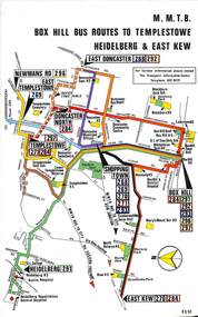
Map, Melbourne & Metropolitan Tramways Board (MMTB), Set of 8 bus route maps, 1977 to 1979
Series of colour route maps for various bus or groups of tram lines for the MMTB. Some have the Transport Information Centre telephone printed on them, others have a label stuck on. Some are finished with a plastic laminate finish on either one or both sides. Show the major cross streets, parks, schools, other tram routes, major stop numbers and railway lines. .1 - Box Hill bus routes to Templestowe - R38/82, Heidelberg and East Kew, includes Doncaster, Shoppingtown and Newmans Road. .2 - Clifton Hill - R2/79 - Elsternwick, Point Ormond and St Kilda Junction .3 - Footscray, Sunshine, Deer Park, Nth Altona, Fishermen's Bend, Highpoint and Williamstown Road - R2/79. .4 - Bulleen - City - Port Melbourne - Garden City Bus Route, including Kew, Collingwood - R6/78 .5 - City - Warrandyte and East Doncaster including Newmans Road, Templestowe, East Doncaster, Donvale, Shopping town, and Kew. R3/82. .6 - West Heidelberg, La Trobe University, Northland - R3/81 .7 - Box Hill, Ringwood to East Doncaster and Warrandyte, Park Orchards, North Blackburn R3/82. .8 - Geelong - Herne Hill, Rollins Road, Donnybrook Rd, North Shore and Corio Villagetrams, tramways, maps, route guide, route numbers, routes, buses, box hill, templestowe, doncaster, east kew, heidelberg, clifton hill, point ormond, elsternwick, footscray, sunshine, deer park, north altona, fishermen's bend, highpoint, williamstown rd, bulleen, kew, collingwood, port melbourne, garden city, warrandyte, donvale, la trobe university, northland, ringwood, park orchards, mitcham, blackburn, geelong -
 Melbourne Tram Museum
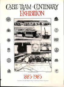
Poster, City of Richmond, "Cable tram centenary exhibition - 1885 to 1985", 1985
Poster - special size printed on gloss titled "Cable tram centenary exhibition - 1885 to 1985". promoting a cable tram to be held at the Carringbush Regional Library, in conjunction with the City of Richmond, during 1985. Features the Richmond tramway line, shows the location of the Engine house, detail of the cable tramway location, images of the proposed tramcars and methods. Image from the La Trobe Library. Has the seals of the Cities of St Kilda, Melbourne, Richmond, Collingwood, Port Melbourne and Melbourne on the right hand side.trams, tramways, cable trams, centenary, richmond, posters -
 Melbourne Tram Museum
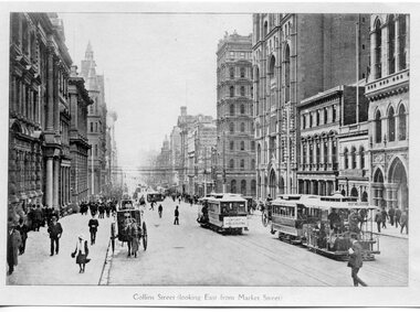
Photograph - Set of 2 Black and White photograph, c1900
Black and white photograph of Collins St, looking east from Market St. Has two cable sets showing the destination of Port Melbourne. 2nd copy from Keith Kings added 6/8/2020 - see images i2 and i3. - different crop. .1 - Black & White Photograph of a postcard made by the TMSV Sales - better version.in ink in the corners "La Trobe" and number 512 45trams, tramways, cable trams, port melbourne, collins st -
 Melbourne Tram Museum
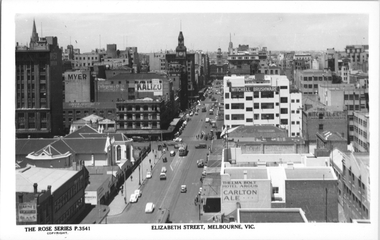
Postcard, Rose Stereograph Co, "Elizabeth Street Melbourne", late 1930s
Rose Series postcard No. P 3541, titled "Elizabeth Street Melbourne", taken from The Argus Building tower on the corner of Elizabeth and La Trobe Streets looking south to Flinders Street, There are eight trams in the view and one horse drawn cart in Lonsdale Street near the corner. St. Francis' Church is in the middle of the photograph with the Myer Emporium Londale Street store in the left of the photo. The white building in the right of the photo is the new Mitchell House built in 1936. Yields information Elizabeth Street late 1930s.Postcard - printed real photograph with Rose Stereograph Co. name on the rear. Two copies held.tramways, trams, w5 class, elizabeth st, lonsdale st -
 Melbourne Tram Museum
Map, Melbourne & Metropolitan Tramways Board (MMTB), MMTB Route Maps, 1979
Series of colour maps for various tram and bus routes, dated 1979. Also contained, not scanned are letters, reports, and specifications for printing these maps for use in shelters etc. Some have the Transport Information Centre telephone printed on them. Some are finished with a plastic laminate finish on either one or both sides. Show the major cross streets, parks, schools, other tram routes, major stop numbers, and railway lines. See also item 3909 for another example of these. Trams 1 - City route guide - R9/77 - showing all route numbers and destinations that passed through the CBD. 2 - Bourke St tram routes - R4/77 - East Brunswick Blyth St and East Preston Tyler St and intermediate routes, routes 95, 96, 97, 90, 89 and 88. 3 - Malvern, East Malvern, Carnegie, and East Brighton Tram Routes (from St Kilda Junction) - R1/79 - shows routes 5, 3, 67, 66, 61, 62, and 64. 4 - Elizabeth St tram routes - R12/77 - Essendon Airport, West Maribyrnong, North Coburg lines, routes 50, 58, 60, 54, 57, 52. 49, 59, 18, 20 and 19 5 - Flinders St tram routes - R5/78 - North Balwyn, East Burwood, routes 48, 40, 41, Hartwell, 28, 74 and 75 6 - Kew - St Kilda Beach - R1/79 - Route 69. 7 - Mont - Albert City - R11/77, shows routes 43. 47. 45. 44 8 - St Kilda Rd Tram Routes R12/77 - details South Melbourne Beach, route 1 and route 2 and St Kilda Beach routes 15, 16, and 55 otherwise shows where the various routes branch off St Kilda Road 9 - Batman Ave tram routes - R9/77 - Wattle Park, North Richmond and Prahran - routes 70, 71, 78 and 79. 10 - Footscray - Moonee Ponds - R3/81 - Route 82 11 - Swanston St tram guide - R1/79 - lists all routes and route numbers that branch or cross Swanston St between Grattan St and St Kilda Junction. 12 - Toorak Camberwell and Glen Iris tram route with Camberwell Junction and Malvern Town Hall, R1/79, routes 8, 7, 6, 72, and 73 shown. 13 - West Preston - Beach tram routes - R12/77 - routes 10, 11, 9 and 12, 14 - William St tram routes - R12/77 - Route 55, 56, and 63 - South Melbourne Depot and Domain. Buses 1 - Footscray, Sunshine, Deer Park, Nth Altona & Fishermans Bend - R2/79 2 - Box Hill bus routes to Templestowe, Heidelberg & East Kew - R6/78 - notes superseded by R3/82 3 - Plan of Russell St Melbourne bus departure bays. 4 - Box Hill, Mitcham & Ringwood bus routes to East Doncaster & Warrandyte - R3/82 5 - City - Warrandyte & East Doncaster bus routes - R3/82 & R6/78 6 - Bulleen - City - Port Melbourne - Garden City Bus route - R6/78 7 - North Altona - City bus route - 11/78 8 - Clifton Hill - Elsternwick - R2/79 9 - La Trobe - Northland - West Heidelberg - City Bus Service via East Freeway - 11/79 and R3/81 10 - Box Hill, Mitcham & Ringwood Bus Routes to East Doncaster & Warrandyte - R10/84 - with the Metropolitan Transit logo.Yields information about tram and bus routes in late 1970s early 1980s.Book - brown comb binding, card and clear plastic covers containing both bound and unbound maps and documents.K C Painter on front cover in ink.tramways, mmtb, tram routes, maps, bus routes, route numbers, routes, route guide -
 Melbourne Tram Museum
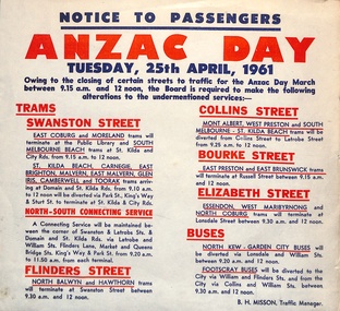
Document - Notice to Passengers, Melbourne & Metropolitan Tramways Board (MMTB), "ANZAC Day", April 1961
Notice to Passengers titled "ANZAC Day", Tuesday 25 April 1961 detailing the service alterations for the March - closure of Swanston St, diversion of trams, termination of trams, connecting services via La Trobe and William Sts, and changes to bus routes. Signed by B H Misson Traffic Manager.Yields information about the changes to the CBD Tram services for the 1961 ANZAC day march.Notice - printed on special size paper.tramways, anzac day, notices and information, timetables, services -
 Bendigo Historical Society Inc.
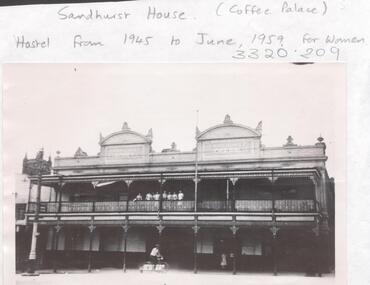
Photograph - LA TROBE UNIVERSITY BENDIGO COLLECTION: SANDHURST HOUSE
A black and white photograph of Sandhurst House now demolished. The building was situated on the corner of Mollison and Mitchell Streets and was used for female student accommodation from 1945 through 1959. Prior to this it was known as the Sandhurst Coffee Palace or Coffee Palace. It was a two storey building with two pediments at the top of the building. Each pediment had a sign Heywood Sandhurst House. On the balcony at the front can be seen seven adults looking out over the street. A gentleman is riding his bicycle in the foreground and a woman is at the front door. St. Paul's Cathedral can be seen in the background on the left hand side. See 3320. 100.bendigo, education, accommodation, la trobe university bendigo collection, collection, bendigo, accomodation, bendigo teachers' college, students, building, site, place, hospitality, entertainment, sandhurst coffee palace, coffee palace, photograph, photographs, photo, history -
 Bendigo Historical Society Inc.
Photograph - LA TROBE UNIVERSITY BENDIGO COLLECTION: SANDHURST HOUSE
A black and white photograph of Sandhurst House which was a hostel catering for female student accommodation from 1945 until 1959. Prior to this it was known as the Coffee Palace or Sandhurst Coffee Palace. The building was situated on the corner of Mollison and Mitchell Streets and has now been demolished. It was a two storey building with verandahs and ornate pediments. At the top of the building are two pediments each with a sign Heywood Sandhurst House. St. Paul's Cathedral can be seen in the background on the left hand side. See 3320.100bendigo, education, bendigo teachers' college, la trobe university bendigo collection, collection, bendigo, education, tertiary education, accommodation, students, building, site, place, sandhurst coffee palace, coffee palace, entertainment, photo, photograph, history, hospitality -
 Bendigo Historical Society Inc.
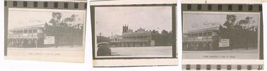
Photograph - LA TROBE UNIVERSITY BENDIGO COLLECTION: SANDHURST HOSTEL
A white envelope with the words ' Sandhurst Hostel 1945 - 1959. ' The number 27 is at the top on the left-hand corner and the number is written on the back also. The envelope contains one large photo of Sandhurst Hostel, three proofs and two negatives of the hostel. This is a two storey building with verandas and ornate pediments. At the top of the building are two pediments each with the sign ' Heywood's Sandhurst House ' on them. There are six people standing on the balcony and below one person and a bicycle parked at the front of the building. St. Paul's Cathedral can be seen in the background.bendigo, buildings, hostel, la trobe university bendigo collection, collection, bendigo, education, bendigo teachers' college, hostel, hostels, sandhurst coffee palace, accommodation, place, buildings, negative, negatives, proof, proofs, coffee palace, tertiary education, teacher training, students