Showing 559 items
matching land sales.
-
 Bacchus Marsh & District Historical Society
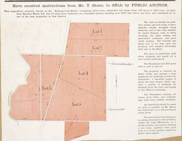
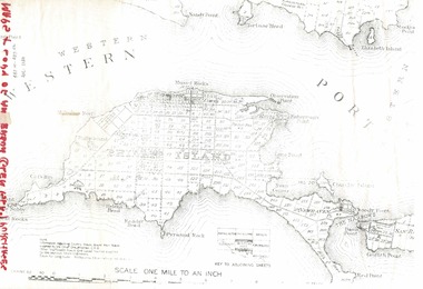
Map, Bullengarook Estate Property Sale. 1911
... Land Sales Bacchus Marsh... family. Land Sales Bacchus Marsh Bullengarook Land Sales ...Bullengarook is a locality located 19 kilometers north of Bacchus Marsh. Pastoral leases for European colonists were granted to people for this area from around the 1840s.The Bullengarook Estate was part of these early pastoral holdings. By the 1900s the property had been owned by the Skene family for a number of years. In early 1911 the property then consisting of 300 acres and the homestead upon it was offered for sale in one lot. It appears however that the sale of the property did not go through in 1911. It was later leased by Thomas Skene to a Mr Coutts in 1915 and ultimately and at a later stage the property was sold by the Skene family.A single page paper map showing land allotments for sale from the Bullengarook Estate. The map is pasted into a bound volume containing 76 maps or plans in total. High resolution digital image stored on BMDHS computer network. land sales bacchus marsh, bullengarook land sales, bullengarook estate, bullengarook vic history -
![Map, Plan of Subdivision of Crown Portion 23 & parts 24-25, Parish of Korkuperrimul [1900s?]](/media/collectors/5e461d8021ea67224c82f2a1/items/675fe058304668462205d4fb/item-media/675fe0ef304668462205d7d6/item-fit-380x285.jpg) Bacchus Marsh & District Historical Society
Bacchus Marsh & District Historical SocietyMap, Plan of Subdivision of Crown Portion 23 & parts 24-25, Parish of Korkuperrimul [1900s?]
... Land Sales Bacchus Marsh.... Land Sales Bacchus Marsh Bacchus Marsh Victoria Maps Land Sales ...The Parish of Korkuperrimul includes a significant section of the township of Bacchus Marsh and extends in western and northern directions from the township area. The date of the subdivision indicated on this plan has not been established. The engineer's stamp on the drawing shows the firm of Muntz and Muntz who were operating under that name in the early part of the 20th century.A single page paper map showing 20 blocks of land for sale in the Parish of Korkuperrimul. Scale 100 feet to 1 inch. The map is pasted into a bound volume containing 76 maps or plans in total. High resolution digital image stored on BMDHS computer network. Stamped: 'Muntz & Muntz Civil Engineers, Architects & Surveyors, Trustees Chambers ?? Cor Collins Street and Bank Placeland sales bacchus marsh, bacchus marsh victoria maps, land sales korkuperrimul parish -
 Bacchus Marsh & District Historical Society
Map, Atkins and Clarke Land Sale situate at Bacchus Marsh 1856 Copy 2
... Land Sales... to purchasing the house and property. This is a very early land sales ...This plan of land allotments for sale indicates the property once owned by the Bacchus family in and around the township area of Bacchus Marsh. The Bacchus family sold their property in Bacchus Marsh to John Atkins and Robert Nalder Clarke in March 1851. Atkins and Clarke kept the property for a number of years until April 1856 when these allotments were put up for sale.This plan is almost identical to another copy held by the Bacchus Marsh and District Historical Society, VC Record 707, BMDHS collection). This plan, VC Record 452 Copy 2, contains a less detail than than VC Record 707 Copy 1. For example the selling agents and the surveyor who created the plan are not indicated on this copy of the plan. This copy of the plan does indicate the name Crook Street on the map. As the Crook family were the buyers of the Manor House property and surrounding land from Atkins and Clarke in 1856 it suggests that this copy is a later one of the earlier version. It is unlikely that the Crook family would have had the adjacent street named after them prior to purchasing the house and property. This is a very early land sales plan for the township of Bacchus Marsh and it therefore provides some clues as to how the early urban development of the township took place. Upon seeing the map in 1911 Bacchus Marsh Express newspaper editor Christopher Crisp wrote "The sale appears to have created the present township, which had a nucleus in earlier times further east", Express, 30 September, 1911, page 3. A single page paper map showing a portions of land available for sale in Bacchus Marsh in 1856. The subdivided land shown was owned by John Atkins and Robert Nalder Clarke, but previously owned by the Bacchus Family and was in and around their Manor House (Mansion) property in Bacchus Marsh.There are 5 portions of land further divided into numerous small portions. The land for sale is bounded by the present day streets of Main Street, Young Street, McFarland Street, Morton Streets, Crook Street, and part of the eastern section extends to the Lerderderg River. Scale: 4 chains to 1 inch. The map is pasted into a bound volume containing 76 maps or plans in total. High resolution digital image stored on BMDHS computer network. Plan of the first portion of land. The property of Messers Atkins and Clarke situate at Bacchus Marsh.land sales, land sales bacchus marsh, manor house bacchus marsh, crook family bacchus marsh -
 The Beechworth Burke Museum
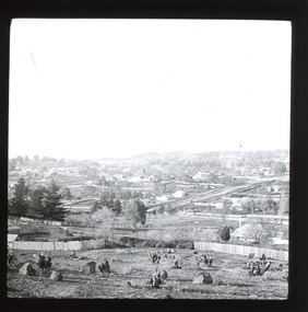
Photograph - Lantern Slide, c1900
... land sales... Beechworth in approximately 1900, after several waves of land sales... Beechworth in approximately 1900, after several waves of land sales ...Miners from Snake Valley lobbied the Victorian Government in 1855 to make land available for sale for farming purposes as an alternative occupation and income for people who wished to stay in the region but move away from gold mining. A secondary motivation was to increase the supply of fresh produce and decrease prices of items that otherwise needed to be transported from Melbourne or other regions. Forty-three country lots were initially offered in the Three Mile area, ranging in size from two to ninety acres and costing from £1 to £3 per acre. An additional eighty-five country lots were auctioned later in the year, in addition to many smaller suburban lots. More lots were offered than sold, initially, but this represented conditions of sale requiring the total purchase cost up front which many people interested in purchasing could not afford, especially as land purchased for farming would accrue substantial additional costs for clearing and labour before becoming productive. Further lobbying activities and the election of parliamentary members sympathetic to the cause took place through the 1850s. Ovens Parliamentary Member, Daniel Cameron, was re-elected in 1856 on a platform of surveying the land for public selection with deferred payment options. Land reform remained an issue in the area through the 1850s and early 1860s, impacting broader decisions in the new State of Victoria relating to voting rights, use of Crown land and the farming of land that wasn't always suitable for the purpose. This photograph depicts Beechworth in approximately 1900, after several waves of land sales resulted in increasingly levels of development. Lantern slides, sometimes called 'magic lantern' slides, are glass plates on which an image has been secured for the purpose of projection. Glass slides were etched or hand-painted for this purpose from the Eighteenth Century but the process became more popular and accessible to the public with the development of photographic-emulsion slides used with a 'Magic Lantern' device in the mid-Nineteenth Century. Photographic lantern slides comprise a double-negative emulsion layer (forming a positive image) between thin glass plates that are bound together. A number of processes existed to form and bind the emulsion layer to the base plate, including the albumen, wet plate collodion, gelatine dry plate and woodburytype techniques. Lantern slides and magic lantern technologies are seen as foundational precursors to the development of modern photography and film-making techniques.This glass slide is significant because it provides insight into Beechworth's built environment and infrastructure in the early Twentieth Century, around the time of Australia's Federation. It is also an example of an early photographic and film-making technology in use in regional Victoria in the time period.Thin translucent sheet of glass with a square-edged image printed on the front and framed in a black backing. It is held together by metal strips to secure the edges of the slide.burke museum, beechworth, lantern slide, slide, glass slide, plate, burke museum collection, photograph, monochrome, indigo shire, north-east victoria, farming, squatters, miners, agriculture, land-clearing, land reform, daniel cameron, land sales, three mile, snake valley, tarrawingee -
 Eltham District Historical Society Inc
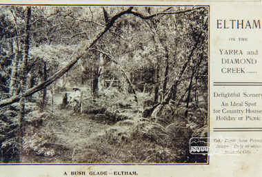
Photograph, A bush glade Eltham, c.1909, 1909c
... Colour photograph from land sales brochure showing a bush... melbourne bush glade eltham bushland Colour photograph from land ...Colour photograph from land sales brochure showing a bush glade Eltham c1909 sent to Mrs Andrewbush glade, eltham, bushland -
 Port Melbourne Historical & Preservation Society
Document, "Plan of Town of Melbourne 1837 A.D.", 1937
... showing first land sales, historical memoranda... 1837 A.D." Also showing first land sales, historical memoranda ...Photocopy of "Plan of Town of Melbourne 1837 A.D." Also showing first land sales, historical memoranda, and an alphabetical list of purchases.town planning, town of melbourne -
Glen Eira Historical Society
Document - Hawthorn Road, 284, Caulfield
... Land Sales.... Marriot Murray S. Land Sales Land Subdivision Migrants Houses Tram ...Report dated 02/05/1988 about 284 Hawthorn Road, Caulfield by the Brighton Historical Society. It provides a history of this site from 1852 to 1974 including tenants and owners from 1923 to 1974. Handwritten working notes are included.hawthorn road, caulfield, mill road, maxwell nellie, glen john, stevens gar, watson george v.e., niblett thomas a., johnson stanley, williams millie, crawford walter h., usher gordon r., paton m.h. mrs., marriot, murray s., land sales, land subdivision, migrants, houses, tram services, bullock h. miss, landells r. miss -
Glen Eira Historical Society
Document - Orrong Estate
... Land sales... Land sales Land values Boyle Ernest Melbourne Document Orrong ...Photocopy of the contract and conditions of sale of Orrong Estate to Ernest Melbourne Boyle, dated 12/01/1916. Includes a hand drawn plan of the area. Photocopied receipt for payment by Ernest Melbourne Boyle, dated 13/01/1916.orrong estate, orrong road, inkerman road, caulfield, labassa grove, pearson grove, sydney arnold best and co, yeo crosthwaite and co, east st kilda sand proprietary limited, east saint kilda sand proprietary limited, seton williams and heathfield, estate agents, legal documents, receipts, real estate agents, financial documents, lawyers, subdivision, land titles, auctions, auctioneers, buildings by condition, land sales, land values, boyle ernest melbourne -
Glen Eira Historical Society
Plan - Nettalie
... Land sales... Grammar School Land subdivision Land sales Land titles Legal ...Land Victoria title documents vol 339 folio 763A and 764 relating to the property Nettalie on the corner of Balaclava and Orrong Rds. These documents detail the history of the land dealing relating to Nettalie and the neighbouring estate Harleston listed as parcels 209a and 209b. These dealing include grants of land, mortgages and conveyance (transfers). The documents include photocopies of handwritten notes of the title history date 1870; a partial copy of an instrument of conveyance dated 1863 and the original titles of the land owned at various times by William Noall, Alfred Shaw, Alfred Desailly and Sir Frederick Grimwade. Within the documents are various hand drawn and printed diagrams of the subdivisions.forsyth william, noall william, cutts william henry, shaw alfred, hailes george button, bakewell john, pascoe john randle, little william, fraser alexander, powell walter, whitney john, hodgeson richard, trollope william thomas, keep edward, blundell mary, carr john bonney, farie claud, fosberry john wallcott, davies john, brady michael, lloyd frederick, turner george, desailly alfred, grimwade frederick s sir, parish of prahran, county of bourke, caulfield north, st kilda east, balaclava road, orrong road, nettalie, netley house, harleston, melbourne grammar school, land subdivision, land sales, land titles, legal documents, homestead, schools, houses -
Glen Eira Historical Society
Map - Cantala
... Land sales... Auctioneers Land sales Land values Architectural features Gardens ...Six pages of handwritten notes, undated and unattributed, detailing the history of the subdivision and demolition of Cantala, Dandenong Road, 40, Caulfield. The notes, which include a list of references, detail the main auction on 21/05/1938 and prices paid for the allotments. Also included in the file are photocopies of three auction posters for the 21/05/1938 auction in 32 allotments. Two of the posters are small and one of these includes a map (107mm x 110mm) of the Cantala Estate. The other poster is spread across three A4 pages and includes a map and plan (204mm x 110mm) of the allotments. There is an extra copy of the final page of this larger poster.miller septimus, miller helen m, mcintyre angus, miller n a, crouch h c, cantala, dandenong road, wiora, alma road, waiora road, findon avenue, cantala avenue, caulfield, caulfield north, st kilda east, yeo grosthwaite and co, abercromby and beatty pty ltd, mansions, land subdivision, house auctions, auctioneers, land sales, land values, architectural features, gardens, advertisements, racehorses, road construction and maintenance, surveyors, lawyers, minute books, trams -
 Glen Eira Historical Society
Document - Thomas, George
... Land sales... Land subdivision Land sales Land prices Land development Land ...This file contains three items Hand written report on property of George Thomas in Orrong Road, dated 04/06/1985, author unknown Photocopy of four page contract and conditions of sale for lot 262 county of Burke Parish of Prahran. George Thomas property was sold to George William Taylor, dated 20/10/1881 The original photograph of a water colour painting of home and garden of George Thomas, Orrong Road, Caulfield by W. Tibbits 1876thomas eric f, thomas george, beemery park, orrong road, seymour road, allison road, mullaly j, j. fulton, taylor george william, warrein road, north road, stone adelaide, orrong road t. fulton, business, farmers, farm workers, farms, gardeners, subdivisions, land subdivision, land sales, land prices, land development, land developers -
Glen Eira Historical Society
Book - Robertson, Alexander William
... Land Sales... Styles Auctions Land Sales Land Subdivision Architects Lawyers ...Contains one item about 'Labassa', called 'Ontario' when owned by Alexander William Robertson: 1/One copy of a thirty-two page colour book, published by the Friends of Labassa and The National Trust in 2004. The book details the history of Labassa (and its owners) as a place for social gatherings and entertaining of Melbourne society of the late nineteenth century, and its letter use as flats and a boarding house. Extensively illustrated with colour photographs, architectural sketches and plans, the book LABASSA: A GRAND VICTORIAN MANSION details Labassa’s architectural significance Please refer to file 1113Y for the other copy of this book. For further information about Labrassa please refer to file 1113.labassa, ontario, sylliott hill, caulfield north, friends of labassa, manor grove, national trust of australia (victoria), balaclava road, orrong road, caulfield, mansions, cobb and co., amatil ltd. (limited), alcoa of australia ltd. (limited), lyall william, mickle john, billing richard annesley judge, robertson alexander william, watson john boyd ii, koch john augustus bernard, hammond victoria, palmer lee, davis kingsley, groenhout chris, worrall bronwyn, balderstone sue, biarujia ian, cassidy darien, davidson rodney ao obe, forge warwick, lewis miles dr., sagazio celestina dr., billing mary, billing williamina, billing richard junior, watson flora kate, robertson eva, robertson nina, robertson emily, robertson john, australian-german association, bicentennial gift to the nation, ferguson and urie, crouch and wilson, tangent design, midas printing (asia) limited (ltd), flats, architectural features, architectural styles, auctions, land sales, land subdivision, architects, lawyers, judges, coaches and carriages, businesspeople, german community, victorian style, grants, voluntary workers, property development, construction (events and activities), gold mining, theatrical productions, stairs, stained glass, settlements, graziers, verandas, cast iron work, marble, balconies, bell towers, towers, bay windows, panoramic views, bedrooms, servants quarters, billiards rooms, rooms, fireplaces, sculpture, servants, marvellous melbourne, land use, depression 1890s, photography, photographers, entrance hall, domestic life, cultural events and activities -
Whitehorse Historical Society Inc.
Document, Property Sales Register, 1932 - 1950
... Land Sales... Mitcham melbourne Shire of Blackburn and Mitcham Land Sales Land ...Property Sales Register for the Shire of Blackburn and Mitcham, arranged chronologically within Ridings, 1932 - 1950.Property Sales Register for the Shire of Blackburn and Mitcham, arranged chronologically within Ridings, 1932 - 1950.Property Sales Register for the Shire of Blackburn and Mitcham, arranged chronologically within Ridings, 1932 - 1950.shire of blackburn and mitcham, land sales, land subdivision, city of nunawading -
Canterbury History Group
Ephemera - Maling's Estate, 1923
... Land Sales... Maling Family Land Sales Land Subdivision Copy of the advertisng ...Copy of the advertisng brochure for the sale of 110 building blocks comprising the Maling Estate. c1924surrey hills, duncan & weller, malings estate, whitehorse road, ross street, weybridge street, grovedale road, james street, maling family, land sales, land subdivision -
Canterbury History Group
Ephemera - Maling's Tramway Estate, 1924
... Land Sales... melbourne Balwyn Malings Tramway Estate Land Sales Land Subdivision ...Brochure for the auction on Saturday 13 December 1924 of 40 home sites comprising Maling's Tramway Estate, Balwyn. Includes photographs of Whitehorse and Balwyn Roads corner, and two houses on the border of the estate.balwyn, malings tramway estate, land sales, land subdivision, whitehorse road, arthur tuckett & son, geo. m hume -
Canterbury History Group
Ephemera - Maling's Tramway Estate, 1924
... Land Sales... melbourne Balwyn Malings Tramway Estate Land Sales Land Subdivision ...Brochure for the auction on 13 December 1924 of 40 building blocks comprising the Maling's Tramway Estate, Balwyn. Includes a small locality plan giving comparative prices per foot of land for some other suburbs.balwyn, malings tramway estate, land sales, land subdivision, shepreth street, the willows, meldreth street, whitehorse road, banool road, maling family, arthur tuckett & son, geo. m. hume -
 Bendigo Historical Society Inc.
Document - LAND AND SURVEY CIRCULARS 1876 - 1883, 1876 - 1883
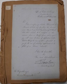
... land sales...ORGANIZATION Bendigo Sandhurst land sales land surveys ...Document: land and survey circulars - brown paper covered journal tied with string along spine. On front cover top LH corner '04A' Stuck to front cover is blue foolscap handwritten letter from Office of Lands and Survey (Occupation Branch) Melbourne 15th. March 1876. Journal contains copies of letters signed by District Surveyor, Sandhurst.Office of Lands and Surveyorganization, bendigo, sandhurst, land sales, land surveys -
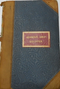
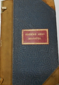
 Bendigo Historical Society Inc.
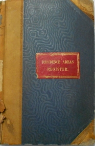
Document - RESIDENCE AREAS REGISTER: SANDHURST VOLUME 13, 1890 - 1892
... land sales...PLACE residence areas Bendigo Sandhurst land sales land ...Register: hard covered register, maroon material with red spine and corners. Contains A-Z index in front section linked with registration details of residence areas in the Sandhurst district, Sandhurst division. Written on front cover in gold ' Residence Areas Register' Pages 1 - 401. Dates from 19 June 1890 to 1 February 1892. Inside front cover, loose index sheets for Volume 13.place, residence areas, bendigo, sandhurst, land sales, land registers -
 Bendigo Historical Society Inc.
Document - LANDS OFFICE - PLANS FORWARDED TO CROWN LANDS OFFICE, 1.9.1871 to 5.4.1880
... land sales...Lands office Sandhurst Bendigo land sales land surveyed ...Document: hard cover journal, brown cover with darker tan spine. 239 pages. Contains index at front of journal. Listings of plans forwarded to Melbourne Crown Lands Office by Bendigo Office. Alphabetical listing in front followed by numbered pages with individual details. Parish, county, allotment, section, surveyor, date remarks.Lands Officelands office, sandhurst, bendigo, land sales, land surveyed, plans -
 Bendigo Historical Society Inc.
Document - RESIDENCE AREAS REGISTER: SANDHURST VOLUME 3, 1883
... land sales...PLACE residence areas Bendigo Sandhurst land sales land ...Register: hard covered register, blue coloured material with dark buff spine and corners. Contains A-Z index in front section linked with registration details of residence areas in the Sandhurst district, Sandhurst division. 'Residence Areas Register' on front cover, ' No. 3' on spine. Register has blue lined pages 1 - 50 detailing residence areas. Dates from 16 June 1883 to 3 October 1883place, residence areas, bendigo, sandhurst, land sales, land registrations -
 Bendigo Historical Society Inc.
Document - RESIDENCE AREAS REGISTER: SANDHURST VOLUME 2, 1883
... land sales...PLACE residence areas Bendigo Sandhurst land sales land ...Register: hard covered register, blue material with dark buff spine and corners. Contains A-Z index in front section linked with registration details of residence areas in the Sandhurst district, Sandhurst division. ' Residence Areas Register' on front cover ' No. 2' on spine. Register has blue lined pages 1 - 50 with details of property registrations. Dates from 30 March 1883 to 16 June 1883.place, residence areas, bendigo, sandhurst, land sales, land registrations -
 Bendigo Historical Society Inc.
Document - RESIDENCE AREAS REGISTER: SANDHURST VOLUME 1, 1882 - 1883
... land sales...PLACE residence areas Bendigo Sandhurst land sales land ...Register: hard covered register, blue material with dark buff spine and corners. Contains A-Z index in front section linked with registration details of residence areas in the Sandhurst district, Sandhurst division. 'Residence Areas Register' on front cover, 'No. 1 'on spine. Register has lined pages 1 - 202 containing details of registrations. Dates from 1 April 1882 to 19 January 1883.place, residence areas, bendigo, sandhurst, land sales, land registrations -
Linton and District Historical Society Inc
Documents - purchase of land, Purchase of land by David McFadzean, 1872 - Allotment A1A, Township of Linton, Parish of Argyle
... Land sales... Victoria. Amending Land Act 1865 Conveyance Land sales Land ...The land was purchased by David McFadzean under the 42nd section of the Amending Land Act, 1865. This allowed long-term tenants ("licensees") of government-held land to purchase ("alienate") the land. The allotment is in present-day Jackson Street, Linton.Twelve A4-size photocopies of documents relating to the purchase of an allotment of land - Allotment A1A, measuring 5 acres, 3 roods and 37 perches - within the boundaries of the Township of Linton. First page is headed "SECTION 31, "LAND ACT 1869". Documents include David McFadzean's application to purchase, notes made about the land and the application by officers of the Board of Land and Works, a plan of the allotment, and information about purchase price and fees.allotment a1a township of linton, david mcfadzean, victoria. amending land act 1865, conveyance, land sales, land purchases, documents and records, james beament -
Linton and District Historical Society Inc
Conveyance document, Conveyance document, 1863 : sale of Allotment 15, Section 1, Township of Linton : Henry Franks to William Hugill
... Land sales... Hugill Conveyance documents Land sales Land purchases J. H. Barr ...The land (with improvements) was sold for £650. Henry Franks had purchased the land for £16.15s at the Sale of Special Lands at Linton in 1861. The land, on the corner of Sussex and Clyde Streets, Linton, was later owned by David McFadzean, and after his death by several generations of the Barr/Greenbank families. It is understood that David McFadzean built the house there in 1873. (House still standing, generally referred to as "Barr's" - current address 64 Sussex Street, Linton.)A3 photocopy of an agreement ("indenture") made in 1863 between Henry Franks and William Hugill for the sale/purchase of Allotment 15, Section 1, Township of Linton. henry franks, william hugill, conveyance documents, land sales, land purchases, j. h. barr, david mcfadzean, allotment 15 section 1 township of linton, 64 sussex street linton -
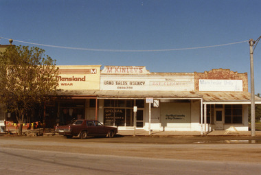 Charlton Golden Grains Museum Inc
Photograph, Charlton Shire, West end Charlton High St c. 1987, c.1987
... Charlton showing Eddie Harris Mensland, McKinleys Land Sales Agency..., McKinleys Land Sales Agency, Hillier's Dry Cleaners and Manchester... Charlton showing Eddie Harris Mensland, McKinleys Land Sales Agency ...Shops at the western end, on the south side of High St Charlton showing Eddie Harris Mensland, McKinleys Land Sales Agency, Hillier's Dry Cleaners and Manchester Unity Agency. Built c. 1890s. The tree shops were demolished in early 1990s. The photo was taken by Shire Engineer c. 1987. Part of a series of photos taken by the Shire.Colour photograph of shops at the western end, on the south side of High St Charlton showing Eddie Harris Mensland, McKinleys Land Sales Agency, Hillier's Dry Cleaners and Manchester Unity Agency. Dark cloured car parked in front of McKinleys. Safety flags around tree to the left of the car. Signage in McKinley's window says 'Special Any Garments Only $'. Signage on Hillier's window says Nor-West Laundry & Dry Cleaners.business, industry, eddie harris mensland, charlton, high street -
 Bendigo Historical Society Inc.
Administrative record - Land Act 1901, no. 1749
... sales. On the first page in red "Land Office Bendigo"... in pen and pencil lists of land sales. On the first page in red ...Brown, beige book titled: Land Act 1901, No. 1749. at the back there are four amendments No. 1831 from 6th April 1903; No. 1957from 30Th November 1904; No 1991from 5th December. 1905 and No. 2228 from 4th January 1910.On the front and back cover in pen and pencil lists of land sales. On the first page in red "Land Office Bendigo"legislation, land act 1901, government -
 Greensborough Historical Society
Folder, Investors in the Grace Park area - Fricker Brothers 1957, 2018_05
... of Death Certificate and Probate documents, list of land sales... and Probate documents, list of land sales and historical notes ...Collection of records regarding the acquisition of land by the Fricker brothers in the Grace Park area of Greensborough, and their sub-division and sale between 1957 and 1975. Researched and edited by Peter Simmenauer Folder containing Certificates of Title, photocopies of Death Certificate and Probate documents, list of land sales and historical notes, researched and edited by Peter Simmenauer grace park, fricker avenue greensborough, desmond court greensborough, desmond fricker -
 Kew Historical Society Inc
Map, Real Estate Map of Bulleen, Templestowe, Lower Templestowe, Doncaster, North Balwyn
... , to identify and record land sales on these. ..., to identify and record land sales on these. Real Estate Map of Bulleen ...A large undated printed map of Bulleen, Templestowe, Lower Templestowe, Doncaster, North Balwyn showing major and minor roads, waterways and proposed facilities in this area of Melbourne.A useful if undated real estate map that allows viewers to compare current and historic aspects of these areasMap of Bulleen, Templestowe, Lower Templestowe, Doncaster, North Balwyn used by JB Thomson & Co, Real Estate Agents, to identify and record land sales on these. There are some markings on the plan indicating the location and price of lots.subdivision plans, bulleen, templestowe, lower templestowe, doncaster, north balwyn -
 Phillip Island and District Historical Society Inc.
Document, 1869 Crown Land sale and map of Phillip Island showing allotments
... Land sales... Historical Robert Anderson Glen Isla John McHaffie maps Land sales ...Anderson and McHaffie were prominent early settlers of Phillip Island. These documents were from the estate of Stan Mcfee snr. Listings of auctions at Gemmell, Tuckett & Co., Collins Street, Melbourne 12 February, 1869HistoricalCopy of map showing allotments for 1869 land sale and hand written note showing allotments, area, prices for purchases of Robert Anderson and notes on McHaffie land.robert anderson, glen isla, john mchaffie, maps, land sales -
Glen Eira Historical Society
Plan - Ristori
... Land Sales... & glass house. House names 'Ristori' Land Sales Sewerage Glen Eira ...Real Estate leaflet for the subdivision sale of the Ristori Estate & Residence on 31/05/1919 by Yeo, Crosthwaite & Co. A map of the 24 subdivisions available plus a locality plan are included along with details of separate sale on 04/06/1919 of the weatherboard buildings, rooms, stables & glass house.house names, 'ristori', land sales, sewerage, glen eira road, brick houses, land subdivision, orrong road, glasshouses, yeo crosthwaite & co melbourne, ripponlea, stables, ristori estate, auctions, drainage, liscard street, st. georges road, balaclava road, glen huntly road, glenhuntly road, elsternwick station, hotham street, weatherboard buildings, elsternwick