Showing 108 items
matching lines of reef
-
 Flagstaff Hill Maritime Museum and Village
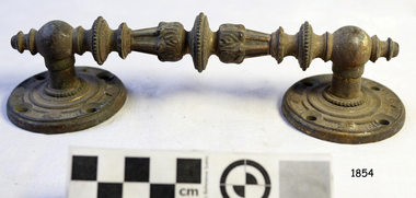
Handle, c. 1859
This brass handle was found on Sea Elephant Bay beach in King Island, Tasmania, in 1913. The donor identified it as being from the wreck of the Newfield. It would could have been part of the fittings or amongst the cargo on the ship. ABOUT THE "NEWFIELD" The Newfield was a three-masted iron and steel barque, built in Dundee, Scotland, in 1889 by Alexander Stephen and Sons. It was owned by the Newfield Ship Company in 1890 and later that year It was registered in Liverpool to owners Brownells and Co. The Newfield left Sharpness, Scotland, on 28th May 1892 with a crew of 25 under the command of Captain George Scott and on 1st June left Liverpool. She was bound for Brisbane, Australia, with a cargo of 1850 tons of fine rock salt, the main export product of Sharpness. At about 9pm on 28th August 1892, in heavy weather, Captain Scott sighted, between heavy squalls, the Cape Otway light on the mainland of Victoria but, due to a navigational error (the ship’s chronometers were wrong), he assumed it to be the Cape Wickham light on King Island, some 40 miles south. He altered his course to the north, expecting to enter Bass Strait. The ship was now heading straight for the south west Victorian coast and at about 1:30am ran aground on a reef about 100 yards from shore and one mile east of Curdie’s Inlet, Peterborough. The ship struck heavily three times before grounding on an inner shoal with 6 feet of water in the holds. Rough sea made the job of launching lifeboats very difficult. The first two lifeboats launched by the crew were smashed against the side of the ship and some men were crushed or swept away. The third lifeboat brought eight men to shore. It capsized when the crew tried to return it to the ship for further rescue The Port Campbell rocket crew arrived and fired four rocket lines, none of which connected with the ship. A local man, Peter Carmody, volunteered to swim one mile to the ship with a line to guide the fourth and final lifeboat safely to shore. Seventeen men survived the shipwreck but the captain and eight of his crew perished. One of the men, apprentice William McLeod, was rescued by local woman Margaret E. MacKenzie. The Newfield remained upright on the reef with sails set for a considerable time as the wind slowly ripped the canvas to shreds and the sea battered the hull to pieces. The Marine Board inquiry found the wreck was caused by a "one man style of navigation" and that the Captain had not heeded the advice of his crew. According to Jack Loney ‘… when the drama was over . . the Newfield was deserted except for the Captain’s dog and two pigs.’ Flagstaff Hill Maritime Museum has several artefacts that have been salvaged from the wreck. A report from SHP documented the following in regards to the Newfield collection: Flagstaff Hill’s collection of artefacts from the Newfield is of historical and archaeological significance at a State level, because of its association with the shipwreck, which is on the Victorian Heritage Register. The collection is significant because of its relationship between the objects. The Newfield collection is archaeologically significant as it is the remains of an international cargo ship. The Newfield collection is historically significant for representing aspects of Victoria’s shipping history and its potential to interpret sub-theme 1.5 (Living with natural processes). The collection is also historically significant for its association with the shipwreck. The Newfield collection meets the following criteria for assessment: Criteria A: Importance to the course, or pattern, of Victoria’s cultural history Criteria B: Possession of uncommon, rare or endangered aspects of Victoria’s cultural history Criteria C: Potential to yield information that will contribute to an understanding of Victoria’s cultural history Ornate brass handle, round plates each end, each with 4 round fixing holes. Found washed up on Sea Elephant Bay beach, King Island 1913, identified by donor as being from the wreck of the Newfield.flagstaff hill, warrnambool, shipwrecked-coast, flagstaff-hill, flagstaff-hill-maritime-museum, maritime-museum, barque newfield, shipwreck-coast, flagstaff-hill-maritime-village, ornate handle, sailing ship fitting, sea elephant bay, king island -
 Flagstaff Hill Maritime Museum and Village
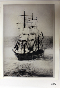
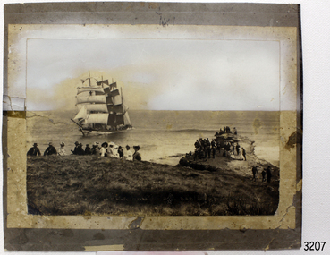
Photograph, post 1889
The photograph shows the three-masted iron and steel bark "Newfield" sailing in open seas. It event would have been between 1889-1892 during the ship's working life. ABOUT THE NEWFIELD The Newfield was a three-masted iron and steel barque, built in Dundee, Scotland, in 1889 by Alexander Stephen and Sons. It was owned by the Newfield Ship Company in 1890 and later that year It was registered in Liverpool to owners Brownells and Co. The Newfield left Sharpness, Scotland, on 28th May 1892 with a crew of 25 under the command of Captain George Scott and on 1st June left Liverpool. She was bound for Brisbane, Australia, with a cargo of 1850 tons of fine rock salt, the main export product of Sharpness. At about 9pm on 28th August 1892, in heavy weather, Captain Scott sighted, between heavy squalls, the Cape Otway light on the mainland of Victoria but, due to a navigational error (the ship’s chronometers were wrong), he assumed it to be the Cape Wickham light on King Island, some 40 miles south. He altered his course to the north, expecting to enter Bass Strait. The ship was now heading straight for the south west Victorian coast and at about 1:30am ran aground on a reef about 100 yards from shore and one mile east of Curdie’s Inlet, Peterborough. The ship struck heavily three times before grounding on an inner shoal with 6 feet of water in the holds. Rough sea made the job of launching lifeboats very difficult. The first two lifeboats launched by the crew were smashed against the side of the ship and some men were crushed or swept away. The third lifeboat brought eight men to shore. It capsized when the crew tried to return it to the ship for further rescue The Port Campbell rocket crew arrived and fired four rocket lines, none of which connected with the ship. A local man, Peter Carmody, volunteered to swim one mile to the ship with a line to guide the fourth and final lifeboat safely to shore. Seventeen men survived the shipwreck but the captain and eight of his crew perished. One of the men, apprentice William McLeod, was rescued by local woman Margaret E. MacKenzie. The Newfield remained upright on the reef with sails set for a considerable time as the wind slowly ripped the canvas to shreds and the sea battered the hull to pieces. The Marine Board inquiry found the wreck was caused by a "one man style of navigation" and that the Captain had not heeded the advice of his crew. According to Jack Loney ‘… when the drama was over . . the Newfield was deserted except for the Captain’s dog and two pigs.’ Flagstaff Hill Maritime Museum has several artefacts that have been salvaged from the wreck. The report from SHP documented the following in regards to the Newfield collection: Flagstaff Hill’s collection of artefacts from the Newfield is of historical and archaeological significance at a State level, because of its association with the shipwreck, which is on the Victorian Heritage Register. The collection is significant because of its relationship between the objects. The Newfield collection is archaeologically significant as it is the remains of an international cargo ship. The Newfield collection is historically significant for representing aspects of Victoria’s shipping history and its potential to interpret sub-theme 1.5 (Living with natural processes). The collection is also historically significant for its association with the shipwreck. Black and white photograph of the three-masted sailing ship “Newfield” in the open sea, sails unfurled. The ship was built in 1859 by Alexander Stephen and Sons Limited of Dundee, Scotland. flagstaff hill, warrnambool, shipwrecked-coast, flagstaff-hill, flagstaff-hill-maritime-museum, maritime-museum, shipwreck-coast, flagstaff-hill-maritime-village, barque newfield, photograph, 1880s sailing ship -
 Flagstaff Hill Maritime Museum and Village
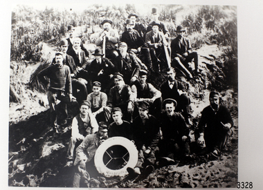
Photograph - Ship Crew, 1889-1892
This black and white photograph shows the crew of the barque Newfield. They are pictured seated on a grassy slope and rock, a lifebuoy from the Newfield, Liverpool, resting on the men in the front row. The men are formally dressed, some with bowler hats, a bow tie and pipe, rather than in their sailing uniforms. ABOUT THE NEWFIELD The Newfield left Sharpness, Scotland, on 28th May 1892 with a crew of 25 under the command of Captain George Scott and on 1st June left Liverpool. She was bound for Brisbane, Australia, with a cargo of 1850 tons of fine rock salt, the main export product of Sharpness. At about 9pm on 28th August 1892, in heavy weather, Captain Scott sighted, between heavy squalls, the Cape Otway light on the mainland of Victoria but, due to a navigational error (the ship’s chronometers were wrong), he assumed it to be the Cape Wickham light on King Island, some 40 miles south. He altered his course to the north, expecting to enter Bass Strait. The ship was now heading straight for the south west Victorian coast. At about 1:30am the Newfield ran aground on a reef about 100 yards from shore and one mile east of Curdie’s Inlet, Peterborough. The ship struck heavily three times before grounding on an inner shoal with 6 feet of water in the holds. Rough sea made the job of launching lifeboats very difficult. The first two lifeboats launched by the crew were smashed against the side of the ship and some men were crushed or swept away. The third lifeboat brought eight men to shore. It capsized when the crew tried to return it to the ship for further rescue The rescue was a difficult operation. The Port Campbell Rocket Crew arrived and fired four rocket lines, none of which connected with the ship. Peter Carmody, a local man, volunteered to swim about one mile off shore to the ship with a line to guide the fourth and final lifeboat safely to shore. He was assisted by James McKenzie and Gerard Irvine. Seventeen men survived the shipwreck but the captain and eight of his crew perished. The Newfield remained upright on the reef with sails set for a considerable time as the wind slowly ripped the canvas to shreds and the sea battered the hull to pieces. The Marine Board inquiry found the wreck was caused by a "one man style of navigation" and that the Captain had not heeded the advice of his crew. According to Jack Loney ‘… when the drama was over . . the Newfield was deserted except for the Captain’s dog and two pigs.’ Peter Carmody was awarded the Bramley Moore medal by the Liverpool Shipwreck and Humane Society for Saving Life at Ssea, which he received by mail on January 21st 1893. Flagstaff Hill’s collection of artefacts from the Newfield is significant for its association with the shipwreck Newfield, which is listed on the Victorian Heritage Registry. The collection is significant because of the relationship between the objects. The Newfield collection is archaeologically significant as the remains of an international cargo ship. The Newfield collection is historically significant for representing aspects of Victoria’s shipping history and its association with the shipwreck. The Letter accompanying the Medal for Bravery awarded to Peter Carmody is significant because the attempt to save lives is associated with the shipwreck Newfield. Black and white photograph of the crew of the sailing ship “Newfield”. The men in formal dress are seated on rocky slope with the ship’s lifebuoy showing the name “NEWFIELD, LIVERPOOL”. Photograph taken 1889-1892 flagstaff hill, warrnambool, shipwrecked-coast, flagstaff-hill, flagstaff-hill-maritime-museum, maritime-museum, shipwreck-coast, flagstaff-hill-maritime-village, newfield, photograph, crew of the newfield, 19th century sailing ship, peterborough, cape otway, medal for bravery -
 Flagstaff Hill Maritime Museum and Village
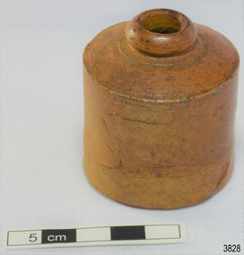
Container - Ink Bottle, 1890s to 1902
This design of ink bottle or ink well was commonly referred to as a ‘penny ink well’ because it was very inexpensive to produce. It is also known as a dwarf bottle. It was recovered from the wreck of the 1895-1902 ship Inverlochy and is part of the John Chance Collection. Pen and ink has been in use for hand writing from about the seventh century up until the mid-20th century. Up until around the mid-19th century a quill pen made from a bird’s feather was used. In the 1850s the steel point pen was invented and could be manufactured on machines in large quantities. In the 1880s a successful portable fountain pen was designed, giving a smooth flowing ink and ease of use. Ink wells, used with steel nib dip pens, were commonly used up until the mid-20th century. The pens only held a small amount of ink so users had to frequently dip the nib of the pen into an ink well for more ink. Hand writing with pen and ink left wet writing on the paper, so blotting paper was carefully used to absorb the excess ink and prevent smudging. Ink could be purchased, ready to use, or in the powdered form, which needed to be mixed with water. After the invention of fountain pens, which had a reservoir of ink, and then ballpoint pens, which also had ink that flowed freely, the dip pen was slowly replaced. However, artisans continue to use nib pens to create beautiful calligraphy. INVERLOCHY 1895-1902 - The Inverlochy was a steel sailing barque built in Scotland in 1895 for international trade. In 1902 the Inverlochy left Liverpool under the command of Captain E.R. Kendrick. There were 21 officers and crew and the captain’s wife Mrs Kendrick, on board, bound for Australia with cargo that included tools, chemicals, liquor (beer, whisky, stout, rum, and brandy), steel, iron, wire netting, hoop iron, tinplate and pig iron), and steel wire for the Melbourne Tramway Company, tiles, soap, soft goods and earthenware. On December 18 almost at their destination, the Inverlochy ran aground on Ingoldsby Reef at Point Addis, near Anglesea. The crew and passengers left the ship via lifeboat and landed at Thompson’s Creek, then walked about 20 kilometres to Barwon Heads. Salvagers were interested in the 10 miles of cable in the hold. Mrs Kendrick’s ‘high grade’ bicycle was amongst the items salvaged but she lost her jewellery and two pianos. By February 1903 the ship had broken up and objects such as bottles and casks of liquor were washed ashore. Bad weather shook the wreck in June 1903, causing the ship’s spars and figurehead to be washed ashore. This ink bottle is historically significant as it represents methods of hand written communication that were still common up until the mid-20th century, when fountain pens and ballpoint pens took over in popularity and convenience. The Ink bottle also has significant as it was recovered by John Chance, a diver from the wreck of the Inverlochy in the late 1960s to early 1970s. Items that come from several wrecks along Victoria's coast have since been donated to the Flagstaff Hill Maritime Village’s museum collection by his family, illustrating this item’s level of historical value. This Ink bottle is significant because of its historical connection to the barque Inverlochy, which is an example of a commercial international steel sailing barque and is listed on the Victorian Heritage Database VHR S338. The Inverlochy is significant for its cargo, which is a snapshot of the kind of goods imported into Australia at the turn of the 19th century, including cable for the Melbourne Tramway Company. The wreck of the Inverlochy is important as an accessible dive site that shows the remains of a large international trading vessel and its contents. It is valuable for an insight into Victorian era of shipping and maritime history. Ink bottle, glazed, prange-brown ceramic cylinder, ring of clay on top for lip, narrow mouth, very short neck on wide shoulder that reaches out to edge of of straight-sided body, flat base. On the shoulder, close to the neck, are concentric lines in the clay. There are dark areas around the lip and mouth opening. The clay appears to have a fold line on its body. The material has flecks of darker material in it. Sediment around shoulder. Handmade. Also called a Penny Ink Well.flagstaff hill, warrnambool, flagstaff hill maritime museum, maritime museum, shipwreck coast, flagstaff hill maritime village, great ocean road, john chance, inverlochy, scotland, captain e.r. kendrick, melbourne tramway company, tramway cable, ingoldsby reef, point addis, anglesea, thompson’s creek, barwon heads, ink bottle, writing equipment, writing accessory, office equipment, stationery, domestic, stoneware, clay, ceramic, pottery, ink well, inkwell, penny ink well, nib pen, dip pen, ink, hand writing, record keeping, household, business, vintage, blotting paper, dwarf ink -
 Flagstaff Hill Maritime Museum and Village
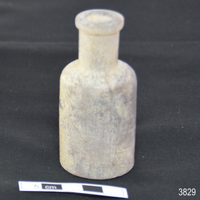
Container - Glass Bottle, mid-19th century to 1902
This handmade glass bottle was recovered from the wreck of the 1895-1902 ship Inverlochy and is part of the John Chance Collection. The bottle has side seams that extend from base to mouth, indicating that it would have been made in a mould. The parallel, diagonal lines are likely to have been made by the molten glass being mouth-blown into the mould. The mould would have also had the pattern for the embossed numbers in the base. The seamless applied mouth would have been added after the bottle was removed from the two-piece mould. The even neck of the bottle would have probably been sealed with a cork or glass stopper. Bottles similar to this one were used for medical (apothecary) and cosmetic purposes. Bottles with these features date from around the late 19th to early 20th century. Bottles began to have embossed numbers on the bases from the late 19th century and the practice continues into modern times. The numbers may represent the date of manufacture i.e. “4188” may be 4th January 1888. It may instead be the date of the patent or design pattern number. This bottle may have been made around 1888 and the latest it could have been made was 1902, the year of the wreck of the Inverlochy. THE INVERLOCHY (1895-1902) - The Inverlochy was a steel sailing barque built in Scotland in 1895 for international trade. In 1902 the Inverlochy left Liverpool under the command of Captain E.R. Kendrick. There were 21 officers and crew and the captain’s wife Mrs Kendrick, on board, bound for Australia with cargo that included tools, chemicals, liquor (beer, whisky, stout, rum, and brandy), steel, iron, wire netting, hoop iron, tinplate and pig iron), and steel wire for the Melbourne Tramway Company, tiles, soap, soft goods and earthenware. On December 18 almost at their destination, the Inverlochy ran aground on Ingoldsby Reef at Point Addis, near Anglesea. The crew and passengers left the ship via lifeboat and landed at Thompson’s Creek, then walked about 20 kilometres to Barwon Heads. Salvagers were interested in the 10 miles of cable in the hold. Mrs Kendrick’s ‘high grade’ bicycle was amongst the items salvaged but she lost her jewellery and two pianos. By February 1903 the ship had broken up and objects such as bottles and casks of liquor were washed ashore. Bad weather shook the wreck in June 1903, causing the ship’s spars and figurehead to be washed ashore. This glass bottle is historically significant as it represents methods of storage and manufacture that were used from the 19th century and into the early-20th century, before machine made bottles were becoming common. The shape and size of the bottle are similar to bottles used for medical and cosmetic purposes in that period. The glass bottle also has significant as it was recovered by John Chance, a diver from the wreck of the Inverlochy in the late 1960s to early 1970s. Items that come from several wrecks along Victoria's coast have since been donated to the Flagstaff Hill Maritime Village’s museum collection by his family, illustrating this item’s level of historical value. This glass bottle is significant because of its historical connection to the barque Inverlochy, which is an example of a commercial international steel sailing barque and is listed on the Victorian Heritage Database VHR S338. The Inverlochy is significant for its cargo, which is a snapshot of the kind of goods imported into Australia at the turn of the 19th century, including cable for the Melbourne Tramway Company. The wreck of the Inverlochy is important as an accessible dive site that shows the remains of a large international trading vessel and its contents. It is valuable for an insight into Victorian era of shipping and maritime history. Bottle; clear glass, round, handmade. Narrow lip is flat across top and on side edge, neck is straight, about a third of the bottle’s height. The shoulder is rounded, and the body has straight sides with two side seams from below the lip to the base, which is shallow. Outer glass surface is rough, inner surface has areas of dried, light coloured substance. The body has several diagonal parallel lines and areas with opalescent shine. Base has embossed inscription. Embossed inscription on base "4188".flagstaff hill, warrnambool, flagstaff hill maritime museum, maritime museum, shipwreck coast, flagstaff hill maritime village, great ocean road, john chance, inverlochy, scotland, captain e.r. kendrick, melbourne tramway company, ingoldsby reef, handmade, glass bottle, apothecary, cosmetic, mould blown, vintage, two-piece bould, point addis, medicine -
 Bendigo Historical Society Inc.
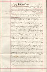
Document - REPORT ON THE BENDIGO GOLDFIELD, EDWARD DYASON
... reef lines... goldmining mining companies reef lines underground workings E.C ...Grey cover document, 21 typed pages with map of goldfield appended. On front page 'Report on the Bendigo Goldfield Central Area. This report is the outcome of an investigation into the present condition and future prospects of the Central Area of the Bendigo goldfield, undertaken with a view to seeing what improved methods could be adopted in the conduct of mining operations to neutralise the recent heavy increase in the cost of labour and mining requisites, and so restore the industry to the level of its previous prosperity' Signed by E.C. Dyason, B.Sc. B.M.E., Commonwealth Chambers, Bendigo, Victoria, 15th November, 1918.bendigo, gold mining, report on goldfield, bendigo goldfield, goldmining, mining companies, reef lines, underground workings, e.c. dyason -
 Bendigo Historical Society Inc.
Document - NEW CHUM, VICTORIA AND HUSTLERS HILL AND REEF LINES
... NEW CHUM, VICTORIA AND HUSTLERS HILL AND REEF LINES... CHUM, VICTORIA AND HUSTLERS HILL AND REEF LINES ...Five page typed document. On top in handwriting ' Original, for self tour'. New Chum Hill is situated in Golden Square, Marong Road on north side, Lilly Street to the east, Chum Street on souther slope and Lansell's Fortuna on the wesern side. Mines on the hill are listed: Lansell's 180, The New Chum and Victoria, the Old Chum, the Lazarus, the New Chum United, the New Chum Consolidated and the Garibaldi. The Mungo group of mines on the New Chum Line of Reef at Eaglehawk are listed: Ellenborough, St. Mungo, Lady Barkly and South Sth Mungo. Victoria Hill mines: Rae's, Wittscheibe and Co., Lansell's 180.Albert Richardson -
 Bendigo Historical Society Inc.
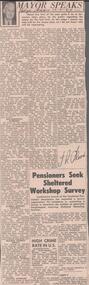
Newspaper - ALBERT RICHARDSON COLLECTION: THE MAYOR SPEAKS: MINE SITES
... reef lines and mines... BENDIGO Mining reef lines and mines Newspaper article 'The Mayor ...Newspaper article 'The Mayor Speaks' dated 12th August 1967, Bendigo Advertiser. Article by J.R. Flood. Mayor of Bendigo, detailing the location of mines including the Duchess of Edinburgh on the New Chum line, the mines on the Christmas line of reef, the Deborah reef mines, and the Sheepshead reef. Mine reclamation schemes are also addressed in the articlebendigo, mining, reef lines and mines -
 Bendigo Historical Society Inc.
Map - BENDIGO GOLD FIELD LONGITUDINAL VERTICAL PROJECTIONS
... reef lines... mining reef lines mining companies geological survey Geological ...Bendigo gold field map showing vertical projections of portions of three anticlinal axial planes showing stratigraphical zones and caps of known saddle reefs. This map forms part of the Geological Survey of Victoria, Structure of Bendigo Goldfield report, No. 47, 1923. H.Herman, late Director of Geological Survey.Geological Survey Victoriabendigo, gold mining, vertical projections, bendigo, goldfield, gold mining, reef lines, mining companies, geological survey -
 Bendigo Historical Society Inc.
Document - CHRISTMAS REEF GOLD MINING CO. COLLECTION: TRIBUTE AGREEMENT
Hand written agreement for five years from 1st August 1903 and dated 15th August 1903. Lease of land for mining purposes between Christmas Reef Gold Mining Co. and Messrs Eddy and party. Christmas Reef Gold Mining Co. would take a percentage of the gold. Signed by Fred Douglas Jones, Solicitor, Thomas Eddy Senior, James Herbert Eddy, Thomas Donald Eddy, Mr J James, R ?all, Clerk to Mr F D Jones. Document has two purple ink stamps and three red seals. Written on heavy paper with double red lines 1.5 cm from the edges.mine, gold, christmas reef gold mining company, christmas reef gold mining company n. l., fred douglas jones, thomas eddy senior, james herbert eddy, thomas donald eddy, r ?all, mr j james -
 Bendigo Historical Society Inc.
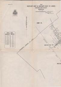
Map - STRUGNELL COLLECTION: HUSTLER'S LINE OF REEF, September 1913
... No 33 Signed H.A.Whitelaw. Drawing shows reef boundary lines... Bendigo hustler's reef & hustler's reef 1 Underground Survey ...Map, Hustler's Line of Reefs, Hustler's Reef & Hustler's Reef No.1 Mines Bendigo.Plate No. X1V (14) Comet Co. .Bulletin No 33 Signed H.A.Whitelaw. Drawing shows reef boundary lines .There is an explanatory box showing depth in feet and inches of the mines .Underground Survey Office, Bendigo.map, bendigo, hustler's reef & hustler's reef 1 -
 Flagstaff Hill Maritime Museum and Village
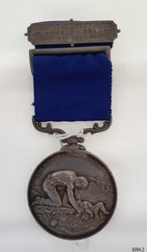
Award - Medal, ca. 1872
This medal is the Liverpool Shipwreck and Humane Society’s “Bramley-Moore medal for saving life at sea 1872”. The Society was formed in 1839. In 1872 Mr John Bramley-Moore donated £500 on condition that the medal have the specific inscription above on its reverse. The Bramley Morre medal was first awarded in 1874 and records show that since that time only one gold medal has been awarded, twenty-two silver medals and seventeen bronze medals, the last being in 1945. This Bromley-Moore medal was awarded to Peter Carmody for his bravery in saving lives on the Newfield shipwreck. The Newfield was a three-masted iron and steel barque, built in Dundee, Scotland, in 1889 by Alexander Stephen and Sons. It was owned by the Newfield Ship Company in 1890 and later that year It was registered in Liverpool to owners Brownells and Co. The Newfield left Sharpness, Scotland, on 28th May 1892 with a crew of 25 under the command of Captain George Scott and on 1st June left Liverpool. She was bound for Brisbane, Australia, with a cargo of 1850 tons of fine rock salt, the main export product of Sharpness. At about 9pm on 28th August 1892, in heavy weather, Captain Scott sighted, between heavy squalls, the Cape Otway light on the mainland of Victoria but, due to a navigational error (the ship’s chronometers were wrong), he assumed it to be the Cape Wickham light on King Island, some 40 miles south. He altered his course to the north, expecting to enter Bass Strait. The ship was now heading straight for the south west Victorian coast. At about 1:30am the Newfield ran aground on a reef about 100 yards from shore and one mile east of Curdie’s Inlet, Peterborough. The ship struck heavily three times before grounding on an inner shoal with 6 feet of water in the holds. Rough sea made the job of launching lifeboats very difficult. The first two lifeboats launched by the crew were smashed against the side of the ship and some men were crushed or swept away. The third lifeboat brought eight men to shore. It capsized when the crew tried to return it to the ship for further rescue The rescue was a difficult operation. The Port Campbell Rocket Crew arrived and fired four rocket lines, none of which connected with the ship. Peter Carmody, a local man, volunteered to swim about one mile off shore to the ship with a line to guide the fourth and final lifeboat safely to shore. He was assisted by James McKenzie and Gerard Irvine. Seventeen men survived the shipwreck but the captain and eight of his crew perished. The Newfield remained upright on the reef with sails set for a considerable time as the wind slowly ripped the canvas to shreds and the sea battered the hull to pieces. The Marine Board inquiry found the wreck was caused by a "one man style of navigation" and that the Captain had not heeded the advice of his crew. According to Jack Loney ‘… when the drama was over . . the Newfield was deserted except for the Captain’s dog and two pigs.’ Peter Carmody was awarded the Bramley-Moore medal by the Liverpool Shipwreck and Humane Society for Saving Life at Ssea, which he received by mail on January 21st 1893. The medal and a letter of congratulations were donated to Flagstaff Hill Maritime Museum by Peter Carmody’s grand-daughter Norma Bracken and her son Stuart Bracken on 25th May 2006. The Medal and Letter of Congratulations join other items in the Newfield collection.The Carmody Medal recognises the bravery of Peter Carmody in risking his life to rescue crew members of the Barque Newfield when it was wrecked near Curdies Inlet in August 1892. The ‘Bramley-Moore medal for saving life at sea, 1872’ was presented by the Liverpool Shipwreck and Humane Society. The medal and accompanying letter have local and international historic significance as they demonstrate both the difficulties associated with navigation and the dangers of shipping along the South West Coast of Victoria in the 19th century and the medal’s association with the Liverpool Shipwreck and Humane Society and John Bramley-Moore, who provided £500 to found the Bramley-Moore medal. The medal is socially significant. It emphasises the importance of Peter Carmody in rescuing victims of shipwrecks with little thought for his own safety. The medal reminds us of the importance of local people to Victoria’s maritime history. The Carmody Medal and Humane Society letter were in the Carmody family until they were presented to Flagstaff Hill Maritime Village, by the grand-daughter and great-grandson of Peter Carmody, on the 25th May 2006. The medal is significant for its complete provenance recorded in the donation documentation. The medal is in very good condition and relatively rare with only 22 silver medals awarded between 1874 and 1945. The Carmody Medal and letter add a human element to the story of the shipwrecks. They give life and significance to the Newfield, its victims and its artefacts. Bramley-Moore medal from the Liverpool Shipwreck and Humane Society, awarded to Peter Carmody. The round,silver medal is attached to a looped blue ribbon by a decorative, swivelling silver connector. The top of the ribbon has a silver pin bar threaded through it. The obverse of the medal has a design of a man kneeling on a floating part of a wreck. He is rescuing a child from the sea. There is a manned boat in the distance rescuing someone from the sea. In the far background there is a sailing ship. The top third of the medal has an inscription around it. The reverse shows a long-legged hen cormorant with extended wings holding an olive branch in its beak. The bird is surrounded by a wreath of oak leaves made from two branches. There is an inscription between the design and the rim that goes all the way around the circumference. There is a name engraved around the edge of the medal. The medal in embedded in a purple velvet panel that rests inside a brown, leather-covered case. The lid of the case has a gold embossed emblem in the cemtre. Both the lid and base have a rectangular gold border. The lid is attached to the base with two brass hinges. The base has a brass push-button catch. The box is lined with padded cream silk. The lining inside the lid has a gold emblem in the centre.The obverse has the words "LORD, SAVE US, WE PERISH". The reverse has the words "BRAMLEY-MOORE MEDAL FOR SAVING LIFE AT SEA" and "1872". Around the edge of the medal are the words "PETER CARMODY, FOR HAVING BEEN MAINLY INSTRUMENTAL IN RESCUING THE CREW OF THE BARQUE NEWFIELD, AUG 29 1892" The pin bar has the words “LIVERPOOL SHIPWRECK & HUMANE SOCIETY” written across it. The gold embossed emblem on the lid of the box has the words in the centre "SHIPWRECK AND …. …. ….FOUNDED 1839" The gold emblem on the cream silk lining has the words “BY APPOINTMENT ELKINGTON & CO” printed on it.medal, shipwrecked coast, flagstaff hill, flagstaff hill maritime museum, maritime museum, flagstaff hill maritime village, shipwreck coast, warrnambool, peter, peter carmody, carmody, bramley moore, newfield, liverpool shipwreck and humane society, 1892, 28 august 1892, august 1892, port campbell, bravery, shipwreck, rescue, nineteenth century, ship, curdie s river, victorian shipwrecks, barque, stuart bracken, norma bracken, gerard irvine, james mckenzie -
 Bendigo Historical Society Inc.
Document - South New Moon Syncline Gold Mine No Liability 1934, James Phillips, January 20th 1934
... reef lines... Phillips George Phillips gold mine reef lines Two page document ...Two page document, carbon copy typed on flimsy paper. On first page ' South New Chum Syncline Gold Mine No Liability', Bendigo. January 20th 1934. Mine Manager's report, Jas. Phillips typed on bottom of second page. Content includes: 'The level south at the 110 ft was driven over 35 years ago by the late Geo Phillips who had a 20 head mill on the lease and as far as I can remember its about 200 ft south and of course the reef iow well above a few feet in on account of it rising in that direction and thousands of tons has been taken out of that particular block and crushed.... the writer worked on that reef in his younger days and we connected with some old workings above us known as the German's Workings collapsed and closed up from the 100 ft level to the surface'. Document is part of the Margaret Roberts Mining Collection. south new moon syncline gold mine, geo phillips, james phillips, george phillips, gold mine, reef lines -
 Bendigo Historical Society Inc.
Document - TYSON'S LINE - EASTERN LINES
BHS CollectionTyped carbon copy and typed copy of General notes on the lines East of the Hustlers. Lines mentioned are: Hustler's, New Chum, Lightning Hill, Tysons, Slaughteryard, Isabella Mine, Ironstone Hill Reef, Nicholson Reef, on which a mine owned by a man named Stevenson mined a fair amount of gold. Ref. Anon; 1899. Spec. Ed. Aust. Min. Stand. June 1st 1899: p 61. Notes prepared by Albert Richardson.mining, parish map, tyson's line, eastern lines, hustler's, new chum, slaughteryard line, lightning hill, tyson's, isabella mine, ironstone hill reef, nicholson reef, mr stevenson, aust min stand 1 june 1899 -
 Flagstaff Hill Maritime Museum and Village
Photograph - Vessel, Sailing Ship, Original image taken between 14 November 1908 and early January 1909
The photograph was taken towards the ESE from Peterborough headland. It reproduces an original landscape view of the FALLS OF HALLADALE shipwreck which occurred at 3 am on 14 November 1908 (and confirms that the vessel was on an ENE tack at the time of the collision). The image includes three groups of formally dressed Edwardian sightseers on the cliff top and an adjacent rock ledge. Subsequent versions of this well-known image are usually cropped to present a striking portrait view, emphasising the vertical lines of the ship’s masts and sails, and excluding the groups of sightseers on the right hand of the original image. The small girl in the foreground and the loose sail on the foremast are common to both the landscape and edited portrait versions of this memorable scene. The photograph was taken at an early stage of the ship’s final days, somewhere between the date of her grounding in mid-November 1908 and early January 1909 (when salvagers began dynamiting her iron masts so they could get to the valuable cargo still in her holds). Firmly wedged between two parts of the reef and with all of her square-rigged sails fully set, the FALLS OF HALLADALE provided a spectacle for many miles along the coast. Over these weeks she attracted hundreds of sightseers, and photographers, before the pounding seas finally broke her weakened hull and she disappeared back into deeper waters. The iron-hulled, four-masted barque, the Falls of Halladale, was a bulk carrier of general cargo. She left New York in August 1908 on her way to Melbourne and Sydney. In her hold, along with 56,763 tiles of unusual beautiful green American slates (roofing tiles), 5,673 coils of barbed wire, 600 stoves, 500 sewing machines, 6500 gallons of oil, 14400 gallons of benzene, and many other manufactured items, were 117 cases of crockery and glassware. Three months later and close to her destination, a navigational error caused the Falls of Halladale to be wrecked on a reef off the Peterborough headland at 3 am on the morning of the 15th of November, 1908. The captain and 29 crew members all survived, but her valuable cargo was largely lost, despite two salvage attempts in 1908-09 and 1910. ABOUT THE ‘FALLS OF HALLADALE’ (1886 - 1908) Built: in1886 by Russell & Co., Greenock shipyards, River Clyde, Scotland, UK. The company was founded in 1870 (or 1873) as a partnership between Joseph Russell (1834-1917), Anderson Rodger and William Todd Lithgow. During the period 1882-92 Russell & Co., they standardised designs, which sped up their building process so much that they were able to build 271 ships over that time. In 1886 they introduced a 3000 ton class of sailing vessel with auxiliary engines and brace halyard winches. In 1890 they broke the world output record. Owner: Falls Line, Wright, Breakenridge & Co, 111 Union Street, Glasgow, Scotland. Configuration: Four masted sailing ship; iron-hulled barque; iron masts, wire rigging, fore & aft lifting bridges. Size: Length 83.87m x Breadth 12.6m x Depth 7.23m, Gross tonnage 2085 ton Wrecked: the night of 14th November 1908, Curdies Inlet, Peterborough south west Victoria Crew: 29The shipwreck of the FALLS OF HALLADALE is of state significance: Victorian Heritage Register No. S255. The Falls of Halladale shipwreck is listed on the Victorian Heritage Register (No. S255). She was one of the last ships to sail the Trade Routes. She is one of the first vessels to have fore and aft lifting bridges. She is an example of the remains of an International Cargo Ship and also represents aspects of Victoria’s shipping industry. The wreck is protected as a Historic Shipwreck under the Commonwealth Historic Shipwrecks Act (1976). The Falls of Halladale shipwreck is listed on the Victorian Heritage Register (No. S255). She was one of the last ships to sail the Trade Routes. She is one of the first vessels to have fore and aft lifting bridges. She is an example of the remains of an International Cargo Ship and also represents aspects of Victoria’s shipping industry. The wreck is protected as a Historic Shipwreck under the Commonwealth Historic Shipwrecks Act (1976).Photograph; sepia-toned black and white, mounted on grey card. Image of a fully rigged sship, the Falls of Halladale, stranded near the shore with a group of people in the foreground seated on the ground. The photograph is well-worn. Description of Image: Quadrant 01, vessel with full set of sails perched on reef with stern submerged; Quadrant 02, predominantly clear sky over flat calm sea; Quadrant 03, two groups of standing sightseers on rocky promontory with three individuals approaching from left foreground; Quadrant 04, fifteen well-dressed sightseers seated on grassed cliff top including one child and six women. There is a deliberately obscured inscription in white ink along the lower border or foreground of the photograph.Lettering of white uppercase in grassed foreground of initial image is smudged out by subsequent development process and largely indecipherable. However pencilled writing on rear of card ― “Mrs Francis” and “Wreck of ‘Falls of Halladale’ Peterborough 1908”.flagstaff hill maritime village, shipwreck coast, peterborough reef, shipwreck photograph, falls of halladale, warrnambool, flagstaff hill, shipwrecked image, flagstaff hill maritime museum, shipwrecked coast, maritime museum, edwardian sightseers, shipwreck spectacle, photograph, mrs francis, wreck of falls of halladale, peterborough 1908, 1908, peterorough, shipwreck -
 Bendigo Historical Society Inc.
Map - HUSTLER'S REEF & HUSTLER'S REEF NO 1 MINES - PLAN OF THE HUSTLER'S REEF & HUSTLER'S REEF NO 1 MINES
Plan of the Hustler's Reef & Hustler's Reef No 1 Mines on the Hustler's Line of Reefs, Bendigo Bulletin No 33, Plate No XIV. No 8 connecting No 10 (Hustler's Reef), No 11 connecting No 13 (Hustler's Reef), No 13 (Hustler's Reef No 1) connecting No 15 (Hustler's Reef) and No 10 Hustler's Reef No 1 rise to Comet Mine. Map shows different levels in relation to the two shafts, the lines of the Hustler's Line of Reefs and the Lightning Hill Line of Reefs, the approximate Boundary of Lease and the Comet Co., the adjoining lease. Table on the left shows the levels and their depths of the two mines. Signed by H A Whitelaw, Underground Survey Office, Bendigo, September 1913. Geological Survey of Victoria emblem. mining, parish map, hustler's reef & hustler's reef no 1 mines, hustler's line of reefs lightning hill line of reefs, comet co., h a whitelaw, underground survey office bendigo, geological survey of victoria -
 Bendigo Historical Society Inc.
Map - COMET MINE - LONGITUDINAL SECTION COMET MINE
Longitudinal section of the Comet Mine on the Hustler's Line of Reef Bulletin No 33, Plate No XXVI signed by H. S. Whitelaw, Underground Survey Office Bendigo, September 1913. Map shows datum lines, depths of levels, approximate boundaries and references to other plans. Note - Plates 4, 8, 13, 20, 26 and 31 form a Longitudinal Section from Fortuna Hustler's to Hustler's Consols Mine. Geological Survey of Victoriamining, parish map, hustler's line of reef, longitudinal section of comet mine bulletin no 33 plate no xxvi, h s whitelaw -
 Bendigo Historical Society Inc.
Map - HUSTLER'S ROYAL RESERVE NO 2 CO. - LONGITUDINAL SECTION OF THE HUSTLER'S ROYAL RESERVE NO 2 CO
Longitudinal Section of the Hustler's Royal Reserve No 2 Co. on the Hustler's Line of Reef Bulletin No 33, Plate No VIII. Note - Plates 4, 8, 13, 20, 26 & 31 form a Longitudinal Section from Fortuna Hustler's to Hustler's Consols Mine. Mines mentioned are the Hustler's Royal Reserve No 2 Main Shaft, Hustler's Royal Reserve No 2 Park Shaft, Royal Hustler's, Imperial Hustler's, Great Extended Hustler's Freehold and the Great Extended. Section shows depth of levels, datum lines and height of sill above sea level yield in oz. of gold. Geological Survey of Victoria emblem. H. Herman, Director, W. Dickson, Secretary for Mines and The Hon. J. Drysdale Brown MLC, Minister for Mines and signed by H S Whitelaw, Underground Survey Office Bendigo, September 1913. mining, parish map, hustler's royal reserve no 2, royal hustler's, imperial hustler's, great extended hustler's freehold, great extended, geological survey of victoria, underground survey office bendigo, h s whitelaw, h herman, w dickson, the hon j drysdale brown