Showing 349 items matching " mansions"
-
 Kew Historical Society Inc
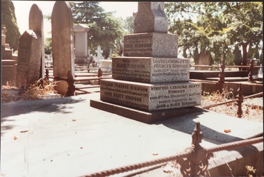
Photograph - Hindson family grave, Boroondara General Cemetery
The sons and daughters of Thomas and Frances Henty were notable settlers, initially in Western Australia, then in Launceston and finally in Victoria. A number of significant mansions in Kew were owned at various stages by members of the immediate family and or their descendants. The Boroondara General Cemetery includes a number of memorials of or to Henty family members.Original colour positive photograph of a Hindson family grave in the Boroondara General Cemetery. This is one of a number of photographs taken c.1987 of graves/headstones of descendants of the Henty family of Victoria. This particular grave is located in Section C/E C 1117A and holds the remains of John Hindson, Alice Hindson, William Francis Hindson. [Alice Hindson was the daughter of Francis Henty]. Other members of the Hindson family are recorded on the grave but are not listed as buried at the site in the Boroondara General Cemetery records of burials. henty family, boroondara general cemetery, john hindson, alice hindson, william francis hindson -
 Kew Historical Society Inc
Photograph - Henty family graves, Boroondara General Cemetery
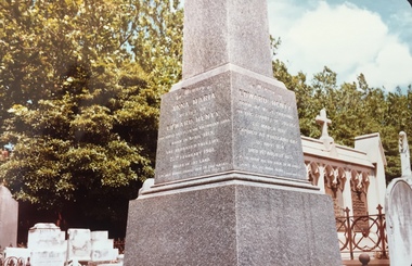
The sons and daughters of Thomas and Frances Henty were notable settlers, initially in Western Australia, then in Launceston and finally in Victoria. A number of significant mansions in Kew were owned at various stages by members of the immediate family and or their descendants. The Boroondara General Cemetery includes a number of memorials of or to Henty family members.Original colour positive photograph of Edward Henty's obelisk in the Boroondara General Cemetery. This is one of a number of photographs taken c.1987 of graves/headstones of descendants of the Henty family of Victoria. The obelisk is located at Section C/E D 0201 and its grave contains the remains of Edward Henty, Anna Maria Henty. henty family, boroondara general cemetery, edward henty, anna maria henty -
 Kew Historical Society Inc
Photograph - Henty family graves, Boroondara General Cemetery
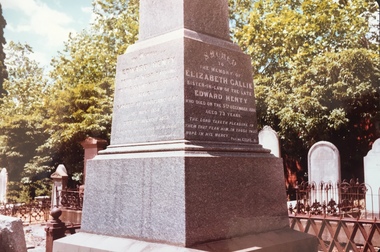
The sons and daughters of Thomas and Frances Henty were notable settlers, initially in Western Australia, then in Launceston and finally in Victoria. A number of significant mansions in Kew were owned at various stages by members of the immediate family and or their descendants. The Boroondara General Cemetery includes a number of memorials of or to Henty family members.Original colour positive photograph of Edward Henty's obelisk in the Boroondara General Cemetery. This is one of a number of photographs taken c.1987 of graves/headstones of descendants of the Henty family of Victoria. The obelisk is located at Section C/E D 0201 and its grave contains the remains of Edward Henty, Anna Maria Henty. henty family, boroondara general cemetery, edward henty, anna maria henty -
 Kew Historical Society Inc
Photograph - Henty family graves, Boroondara General Cemetery
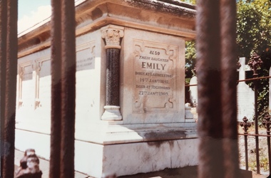
The sons and daughters of Thomas and Frances Henty were notable settlers, initially in Western Australia, then in Launceston and finally in Victoria. A number of significant mansions in Kew were owned at various stages by members of the immediate family and or their descendants. The Boroondara General Cemetery includes a number of memorials of or to Henty family members.Original colour positive photograph of Edward Henty's obelisk in the Boroondara General Cemetery. This is one of a number of photographs taken c.1987 of graves/headstones of descendants of the Henty family of Victoria. henty family, boroondara general cemetery, edward henty, anna maria henty -
 Kew Historical Society Inc
Photograph, J F C Farquhar, Studley Park Road, 1891
At the beginning of the 1890s, the Kew businessman and Town Councillor, Henry Kellett, commissioned J.F.C. Farquhar to photograph scenes of Kew. These scenes included panoramas as well as pastoral scenes. The resulting set of twelve photographs was assembled in an album, Kew Where We Live, from which customers could select images for purchase.The preamble to the album describes that the photographs used the ‘argentic bromide’ process, now more commonly known as the gelatine silver process. This form of dry plate photography allowed for the negatives to be kept for weeks before processing, hence its value in landscape photography. The resulting images were considered to be finely grained and everlasting. Evidence of the success of Henry Kellett’s venture can be seen today, in that some of the photographs are held in national collections.It is believed that the Kew Historical Society’s copy of the Kellett album is unique and that the photographs in the book were the first copies taken from the original plates. It is the first and most important series of images produced about Kew. The individual images have proved essential in identifying buildings and places of heritage value in the district.In this view of Studley Park Road, looking northeast to the Junction, the photographer invites the viewer to participate in a point-of-view that emphasises the elevated, tranquil vantage point of the hill in contrast to the bustling commercial area in the distance. The view emphasises the exclusiveness of Studley Park, with its high fences behind which a number of significant Kew mansions were concealed. Contemporary advertisements for the sale of mansions in Studley Park Road often included fulsome descriptions of their elaborate formal gardens, as well as paddocks for grazing, stabling and dairies. None can be seen here. The use of high, protective wooden pickets to surround the newly planted avenue of elms on the south side of the road appears to be typical of the period. Similar examples can be seen in early photographs of Wellington and Princess Streets.The horse and carriage, selected as a central focus of the view, reinforces the residential, exclusive nature of this part of Kew in the early 1890s. Studley Park Roadkew illustrated, kew where we live, photographic books, henry kellett -
 Kew Historical Society Inc
Plan, Melbourne & Metropolitan Board of Works : Borough of Kew : Detail Plan No.1575, 1905
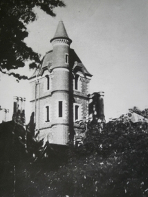
The Melbourne and Metropolitan Board of Works (MMBW) plans were produced from the 1890s to the 1950s. They were crucial to the design and development of Melbourne's sewerage and drainage system. The plans, at a scale of 40 feet to 1 inch (1:480), provide a detailed historical record of Melbourne streetscapes and environmental features. Each plan covers one or two street blocks (roughly six streets), showing details of buildings, including garden layouts and ownership boundaries, and features such as laneways, drains, bridges, parks, municipal boundaries and other prominent landmarks as they existed at the time each plan was produced. (Source: State Library of Victoria)This plan forms part of a large group of MMBW plans and maps that was donated to the Society by the Mr Poulter, City Engineer of the City of Kew in 1989. Within this collection, thirty-five hand-coloured plans, backed with linen, are of statewide significance as they include annotations that provide details of construction materials used in buildings in the first decade of the 20th century as well as additional information about land ownership and usage. The copies in the Public Record Office Victoria and the State Library of Victoria are monochrome versions which do not denote building materials so that the maps in this collection are invaluable and unique tools for researchers and heritage consultants. A number of the plans are not held in the collection of the State Library of Victoria so they have the additional attribute of rarity.Original survey plan, issued by the MMBW to a contractor with responsibility for constructing sewers in the area identified on the plan within the Borough of Kew. The plan was at some stage hand-coloured, possibly by the contractor, but more likely by officers working in the Engineering Department of the Borough and later Town, then City of Kew. The hand-coloured sections of buildings on the plan were used to denote masonry or brick constructions (pink), weatherboard constructions (yellow), and public buildings (grey). Plan No.1575 shows that in the area bounded by Wellington Street, Edgevale Road, Glenferrie Road, and Cotham Road, there had already been significant subdivision of land and houses constructed. As one of the highest points in Kew, as expected, there were already some significant mansions built on large allotments of land. Many of these mansions are identified by name on the plan such as ‘Kelso’, ‘Abbotsford’, ‘Clarendon’ and ‘Ashlyn’ in Cotham Road. Other houses of equal size are unnamed on the plan.melbourne and metropolitan board of works, detail plans, maps - borough of kew, mmbw 1575, cartography -
 Warrnambool and District Historical Society Inc.
Slides, Box of Glass Slides Capital Theatre, 1940s
These glass slides were made to be used at interval time at the Capitol Theatre in Kepler Street, Warrnambool. The Capitol Theatre (originally the Warrnambool Theatre) was erected in 1930 on the site occupied by the Hotel Mansions which included a Palais de Danse and a Mansions Theatre. All were destroyed by fire in 1929. The Capitol Theatre was built in the Spanish Mission style and is one of the few surviving Spanish Mission style theatres in Victoria. However the interior was largely altered in 1994 when the Capitol was converted into a three-screen complex. But some decorative features of the old interior were kept and these included the original proscenium. Stan Stevens and his family were associated with the Capitol Theatre management for many years from 1972. The Capitol Theatre still operates today. These slides are of considerable importance as they are a wonderful example of picture theatre-going in the 1940s and 50s when slides were shown during the interval times and many of these were locally made. The reason for showing the words of songs is not known but it is presumed they had sing-a-longs during the intervals, possibly to boost morale during the days of World War Two. The advertising slides are of particular interest and feature such local businesses as the Woollen Mill, Sungold Dairies, E.A. Wright Motors and Alex Donaldson Timber and Hardware Supplies. These are small square glass slides (numbered1 to 92) which were shown in the 1940s at the Capitol Theatre in Warrnambool at interval time (advertisements, words of songs etc). Some of the slides have been professionally produced and some, especially the words of songs, have been hand-made and handwritten or typed. Some are in colour and some are blank. In others the contents have been obscured or obliterated. Most of the slides have been taped around the edges and some have more sturdy frames made of tape. capitol theatre, warrnambool, stan stevens -
 Warrnambool and District Historical Society Inc.
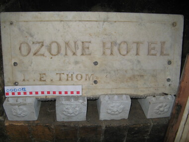
Plaque - Nameplate, marble, Ozone Hotel, C 1900
The Ozone Hotel was formerly the Grand Ozone Coffee Palace which was erected in 1890 at a cost of around ten thousand pounds. Coffee Palaces were temperance hotels which were popular in the latter part of the 19th century which offered recreation and superior accommodation. The coffee palace operated until 1915 and was then closed before re-opening in 1920 as Hotels Mansions. It had major renovations including a large theatre area. February 23rd 1929 saw the most spectacular fire in Warrnambool's history when the Hotel mansions was burnt to the ground. Evelyn O'Brien was granted a temporary licence and in September 1930 she was given permission to rebuild. The new hotel named Hotel Warrnambool was opened in March 1931. The name plate is visible in photographs of the original Directors of the Grand Ozone. Mrs Lilias Euphemia Thom was a licensee of the Ozone hotel from 1907-1910.A link to a significant part of Warrnambool's streetscape and grand buildings.Marble name plate Ozone Hotel, with a shallow decorative groove 30mm in from edge, 4 mounting holes in each corner, an inscription L E Thom has 6 holes in lower portion perhaps used to attach the name of subsequent licensees. Ozone Hotel L E Thom grand ozone coffee palace, warrnambool history, hotel warrnambool, hotel mansions warrnambool, l thom -
 Kew Historical Society Inc
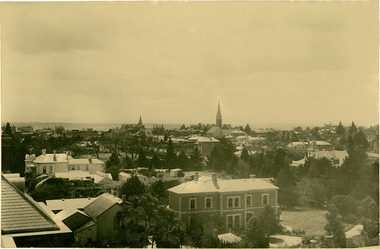
Photograph, J F C Farquhar, Bird's Eye View Looking North, 1891
At the beginning of the 1890s, the Kew businessman and Town Councillor, Henry Kellett, commissioned J.F.C. Farquhar to photograph scenes of Kew. These scenes included panoramas as well as pastoral scenes. The resulting set of twelve photographs was assembled in an album, Kew Where We Live, from which customers could select images for purchase.The preamble to the album describes that the photographs used the ‘argentic bromide’ process, now more commonly known as the gelatine silver process. This form of dry plate photography allowed for the negatives to be kept for weeks before processing, hence its value in landscape photography. The resulting images were considered to be finely grained and everlasting. Evidence of the success of Henry Kellett’s venture can be seen today, in that some of the photographs are held in national collections.It is believed that the Kew Historical Society’s copy of the Kellett album is unique and that the photographs in the book were the first copies taken from the original plates. It is the first and most important series of images produced about Kew. The individual images have proved essential in identifying buildings and places of heritage value in the district.This panoramic view was probably taken from the roof of Xavier College. It invites the viewer to look down on the buildings and streets of Kew, and across to the distant horizon. Mansions and solid bourgeois villas dominate the view of Charles and Wellington Streets. The imposing spires of the Presbyterian and Methodist Churches, built in one of the highest areas of Kew, can be seen in the distance. In the foreground, the photographer includes three significant mansions: Molina, Roxeth and Elsinore. Molina, in the foreground, and the group of weatherboard buildings in its yard was used at this stage for the privately operated ‘Kew High School’ (founded 1872). Roxeth, the home of Herbert Henty can be identified by its distinctive four-sided tower. All three buildings are now part of Trinity Grammar. Other built structures observable in the photograph include Wilton (now the Kew RSL), designed by Guyon Purchas for Dr William Walsh in 1886, and the only known image of the Prospect Hill Hotel prior to the renovation of 1935. Bird's Eye View Looking Northkew illustrated, kew where we live, photographic books, henry kellett -
 Glen Eira Historical Society
Caulfield Properties
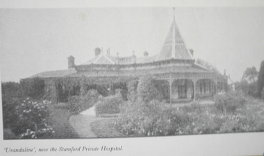
Photograph of Urandaline, that became the Stamford Private Hospital , date unknowncaulfield, urandaline, stamford private hospital, hospitals, mansions -
 Glen Eira Historical Society
Caulfield Properties
Photograph of Crotonhurst mansion, date unknowncaulfield, caulfield north, hawthorn road, crotonhurst, mansions -
 Warrnambool and District Historical Society Inc.
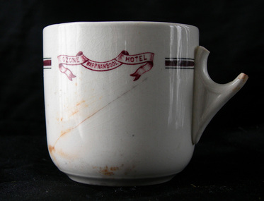
Domestic object - Tea cup, Ozone Hotel, Warrnambool, C 1900
The Ozone Hotel, formerly the Grand Ozone Coffee Palace, was erected in 1890 at a cost of around ten thousand pounds at the corner of Kepler and Koroit streets by a company of local business men and leased out. Coffee Palaces were temperance hotels, which were popular in the latter part of the 19th century and offered recreation and superior accommodation. In 1891, the Coffee Palace was granted a wine licence. In 1895, Thomas Randall was the proprietor of the building and it was renamed the Ozone Hotel. The coffee palace operated until 1915 and was then closed before re-opening in 1920 as Hotels Mansions. It had major renovations including a large theatre area. February 23rd 1929 saw the most spectacular fire in Warrnambool's history when the Hotel Mansions was burnt to the ground. Evelyn O'Brien was granted a temporary licence and in September 1930 she was given permission to rebuild. The new hotel named Hotel Warrnambool was opened in March 1931. This cup is a remnant of the Ozone Hotel.The Ozone Coffee Palace and later the Ozone Hotel Hotel Mansions was a significant grand building in Warrnambool. The destruction by fire in February 1929 was a major loss to the town. This cup, although damaged, is of considerable importance as it is one of the few surviving objects from the Ozone Hotel. The cup provides a link to this important part of Warrnambool's history.Tea cup with broken handle, 3 lines near the rim. The two finer our lines are dark green and the thicker, middle line is dark red with a scrolled banner motif - Ozone Warrnambool Hotel in sienna colour. The cup has a crack on the side and some staining. There is significant crazing of the glaze. The cup has potentially been damaged by fire.Ozone Warrnambool Hotelgrand ozone coffee palace, warrnambool, ozone cup -
 Canterbury History Group
Photograph - Canterbury Mansions, Jan Pigot, 1993
Coloured photograph of Canterbury Mansions on the western corner of Wattle Valley Road and Canterbury Road, Canterbury. Built in 1889 for William Malone whose family owned it until the 1920s (known as Malone's Hotel and later Canterbury Club Hotel). Several other licensees until the local option poll of 1920 resulted in its closure as a licensed hotel. Continued as a guest house or private accommodation until its sale and redevelopment in the 1990s as professional suites.canterbury, canterbury mansions, malones hotel, canterbury club hotel, hotels, canterbury post office, wattle valley road, canterbury road, maling road, telegraph and light poles -
 Kew Historical Society Inc
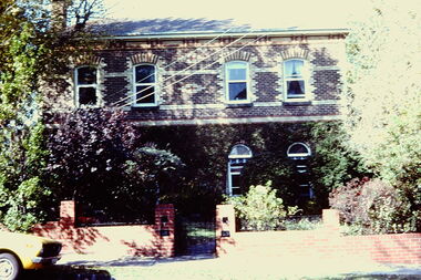
Slide - 4 Selbourne Road, Kew, 1979
One of a group of slides taken by members of the Society of built heritage in Kew in 1979-80. The selection of subject matter reflects the priorities of the period. The colour of some slides has degraded.The slides represent a snapshot in time of built architecture in Kew, much of which has changed in the forty-plus period since they were created.Colour positive transparency (slide) of 4 Selbourne Road, Kew, the former home of Sir Wilfred Kent-Hughes (1895-1970) who was the State Member for Kew from 1927-1949. Subsequently he was elected to the Federal Parliament as the Member for Chisholm. The two-storey, double fronted, polychrome brick house is within the City of Boroondara's Glenferrie Road Precinct, which includes a number of individually significant architectural designs, the majority of which are Victorian mansions.historic houses -- kew (vic.), 4 selbourne road -- kew (vic.), sir wilfred kent-hughes -
Federation University Historical Collection
Poster, The Tempest, 2003
OZACT was founded in 1995 by actor / director, Bruce Widdop. THE TEMPEST at Loch Ard Gorge marked the commencement of a line of impressive outdoor productions. The company has since gained a reputation as one of Australia's leading environmental Shakespeare companies, producing some of the best outdoor Shakespeare in South Eastern Australia. The company performs in wild and natural locations, from garden to seaside and mountains to mansions across Victoria and South Australia. Poster showing Bruce Widdop in Loch Ard Gorge - advertising the show 'The Tempest'.performing arts, bruce widdop, loch ard gorge -
Glen Eira Historical Society
Document - TOURS
There are two copies of the Discover Caulfield guide produced by the Caulfield Historical Society. One from 1982 which contains twelve pages, seven of which are typed and the last five a continuation of the guide added later, hand-written. The other is a modern typed version of the same document, including information at the end that "Notes prepared by R. Ballantyne, 25th July, 1982, updated by Betty Snowball, 1992 and Gladys Vallati 4th August, 1995". They both detail a pictorial tours of the mansions and gardens in the City of Caulfield, similar but not identical.caulfield, mansions, gardens, homes, ‘lirrewa’, lirrewa grove, caulfield city hall, smith sydney, ‘halstead’, bambra road, halstead road, caulfield historical society, messrs. upton and smith, civic establishments, dickson james dr., houses, national trust, st. stephen’s church, balaclava road, gothic (revival) architecture, messrs. haddon and henderson, st. aloysius, archbishop of melbourne mannix dr., caulfield park, hawthorn road, inkerman road, kambrook road, paddy’s swamp, cannizzo philip, caulfield city council, trams, orrong road, grimwade house, ‘harleston’, grimwade frederick sheppard, primary schools, caulfield art centre, ‘stanmark’, art galleries, ‘craigellachie’, person william, pearson eliza, francis newton mr., greenmeadows gardens, milburn grove, greenmeadows house, lempriere john, mayors, ‘glenfern’, boyd john captain, boyd martin, ‘myoora’, alma road, ‘bagatelle’, christian thomas, henderson anketell, flats, building construction, ‘burreel’, kooyong road, burreel avenue, francis john, stephen sidney, allan george l., ‘royston’, renwick s. mrs., sargood frederick sir., ‘glen eira’, ricketson henry, caulfield hospital, royal southern memorial hospital, caulfield general medical centre, ‘ripponlea’, reed and barnes, architects, towers, rippon emma, rippon thomas, guilfoyle william, employees, ‘the village houses’, regent street, st. george’s road, cottages, bent thomas sir., jones louisa mrs., nathan benjamin, ‘anselm’, glenferrie street, queen anne style, haddon robert, historical buildings, princes’ park, ‘glenmore’, watts thomas, more hugh, glenhuntly road, gates, villas, ‘hopetoun’, hopetoun street, webb charles, hopetoun hospital, harleston park, allison street, langdon montague, langdon harry joseph, ‘tarqua’, ‘labassa’, manor grove, koch john, robertson a. w., wagner john, ‘ontario’, trinity congregational church, grange road, glen huntly, churches, greek orthodox church, ‘fairfield hall’, north road, younger james, glenhuntly post office, smith alfred, smith anne, methodist church, ‘lambros the cobbler’, railways, ballantyne r., snowball betty, kahlyn private hospital, ‘kynaston’, st. mary’s jubilee school, festivals and celebrations, st. mary’s anglican church, church of england, bishop moorhouse, joynt donoman, elsternwick post office, elsternwick, elsternwick bowling club, elsternwick rsl, caulfield grammar school, davis henry rev., selwyn street, elsternwick railway station, glen eira road, barnett r. j. rev., tudor court, world war 1914-1918, ‘fairhaven’, hope george, caulfield library, plaques, cannons, ‘janvec joinery’, parkside street, ‘parkside court’, clarence street, ‘streetscene’, grange road, greenhouses, vallati gladys -
Glen Eira Historical Society
Article - Anderson, Adam
Photocopy of a letter of reference for Adam Anderson, Head Gardener at Ripponlea by Julia Sargood Photocopy of 8 page pamphlet ‘Portrait of a Gardener: Adam Anderson” by Richard Heathcote includes photographs and diagrams dated circa 1996 Photocopy of article from “Weekend” dated 21/09/1996 About Adam Anderson at Ripponlea includes photographs of him and his descendant Malcolm Anderson Photocopy of article from “Port Phillip/Caulfield Leader” date 23/09/1996 concerning Adam Anderson his descendant Malcolm Anderson and the exhibition at Ripponlea about Adam Anderson which ran from 30/8/1996 to 30/11/1996anderson adam, sargood frederick sir, sargood julia, mansions, ripponlea, gardeners -
 Glen Eira Historical Society
Caulfield Properties
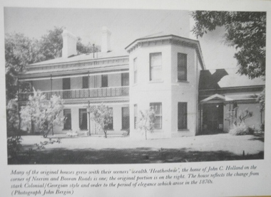
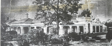
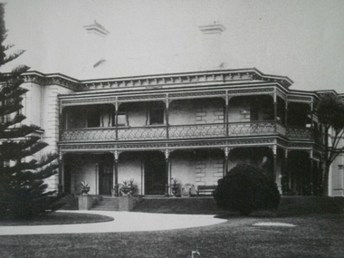
Photograph of Heatherbrae owned by John Holland, date unknownglen huntly, neerim road, heatherbrae, holland, john c, mansions -
 Glen Eira Historical Society
Caulfield Properties
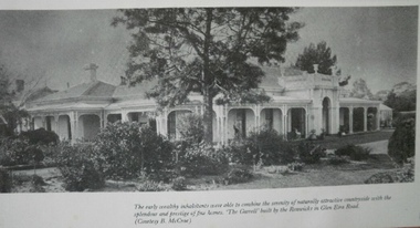
Photograph of The Garrell built by Samuel Renwick, date unknowncaulfield north, glen eira road, the garrell, renwick, samuel, mansions -
 Glen Eira Historical Society
Caulfield Properties
Photograph of Harleston, now Grimwade House, Sep 27 1905caulfield, caulfield north, orrong road, harleston, grimwade house, mansions -
 Glen Eira Historical Society
Caulfield Properties
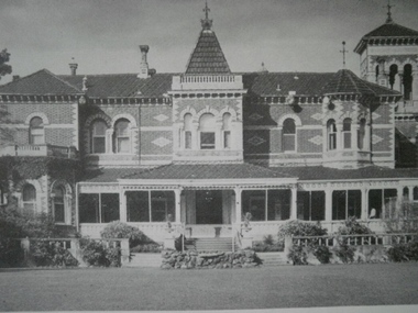
Photograph of Rippon Lea, home of Sir Frederick Sargood, date unknownelsternwick, hotham street, mansions, rippon lea, sargood, sir frederick -
 Glen Eira Historical Society
Caulfield Properties
Photograph of The Garrell built by Samuel Renwick, date unknowncaulfield north, glen eira road, the garrell, renwick, samuel, mansions -
 Glen Eira Historical Society
Caulfield Properties
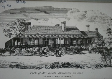
Photograph of Waiora, owned by James Gill circa 1864caulfield north, dandenong road, waiora, gill, james, mansions -
 Glen Eira Historical Society
Caulfield Properties
Photograph of Merton, residence of J. W. Stephen, circa 1880caulfield north, avoca grove, merton, mansions, stephen, j. w -
 Glen Eira Historical Society
Caulfield Properties
Photograph of Myoora circa 1900, owned by Thomas Christiancaulfield north, alma road, myoora, mansions, christian, thomas -
 Glen Eira Historical Society
Caulfield Properties
Photograph of Myoora circa 1886, owned by Thomas Christiancaulfield north, alma road, myoora, mansions, christian, thomas -
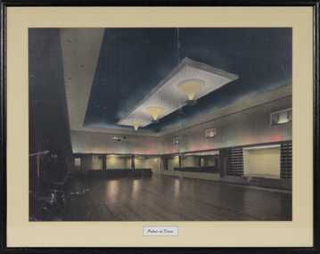 Warrnambool and District Historical Society Inc.
Photograph - Framed Coloured Photograph of The Palais, Palais de Danse
The first Palais dance theatre in Warrnambool was established in the Hotel Mansions on the corner of Kepler and Koroit Streets. When the hotel was destroyed by fire in 1929 the Palais was moved to the Oddfellows Hall in Koroit Street operating as a cinema. In 1939 the area in the Oddfellows Hall was converted into a dance floor, a skating rink and a squash court. The Palais dance hall continued until 1974. It had been a major entertainment venue in Warrnambool featuring many well known bands and singers over the years. This photograph is a fine memento of a most important entertainment venue in Warrnambool in the second half of the 20th century.A colour photograph of the interior of a dance hall showing the dance space, the lighting and the alcoves. The photograph is in two sections placed together. It is mounted on a yellow cardboard mount with a cut-out, printed name in cursive script. The black frame is made of composite material. A glass covering is over the photograph. On the back is a wire attachment for the hanging of the frame. There are crease and scratch markings in the bottom of the photograph.Palais de Dansepalais de danse warrnambool, the palais warrnambool, interior of the palais warrnambool, dance hall warrnambool, warrnambool -
 Kew Historical Society Inc
Plan - Subdivision Plan, Windella-Darnley Subdivision, Studley Park, 1920s
Subdivision plans are historically important documents used as evidence of the growth of suburbs in Australia. They frequently provide information about when the land was sold on which a built structure was subsequently constructed as well as evidence relating to surveyors and real estate and financial agents. The numerous subdivision plans in the Kew Historical Society's collection represent working documents, ranging from the initial sketches made in planning a subdivision to printed plans on which auctioneers or agents listed the prices for which individual lots were sold. In a number of cases, the reverse of a subdivision plan in the collection includes a photograph of a house that was also for sale by the agent. These photographs provide significant heritage information relating house design and decoration, fencing and household gardens.Version 1 of two subdivision plans (the later one is MAP.0027) for the section of Studley Park Road near the Junction on the south side. Named in the subdivision are the mansions of Darley and Windella (now demolished). Before the subdivision of Darley and Windella, both houses fronted Studley Park Road. Both houses appear to be advertised as lots in the subdivision. Bisecting the subdivision is a street, Antrim Avenue that was never constructed. A street, which was subsequently constructed in this vicinity, was Merrion Place, which now runs between Studley Park Road and Highfield Grove. There are 14 proposed lots in this subdivision."Antrim Avenue. See over for new plan"subdivision plans - kew, studley park, windella, darnley, studley park road -- kew (vic.), merrion place -- kew (vic.), merrion grove -- kew (vic.), highbury grove -- kew (vic.) -
 Glen Eira Historical Society
Document - Cobrilla
A one page, undated, unattributed, handwritten transcription of an article in “The Australasian” of 02/03/1912 describing the house Cobrilla on the corner of Dandenong Road and Alma Road. Cobrilla was to be auctioned on 18/03/1912. The file also includes three black and white photographs (86mm x 140mm) of the interior of Cobrilla accompanied by a copy of the photograph and handwritten descriptions. Also included is one black and white photograph (86mm x 140mm) of the exterior of Cobrilla accompanied by a handwritten description and a larger version of the same photograph (253mm x 202mm).cobrilla, dandenong road, alma road, caulfield north, connell ernest h, mansions, architectural features -
 Glen Eira Historical Society
Photograph - Craigellachie
This file contains three black and white photographs of the property 'Craigellachie': 1/An undated black and white photograph of the west front exterior of the house. 2/An undated black and white interior photograph of the Chinese drawing room. 3/An undated black and white photograph showing detail of the etched glass panels in the entrance door. File also contains a research note about the possible provenance of the photographs being either previous resident Mrs C. S. Elliott, or a photographer member of the then Caulfield Historical Society.craigellachie, lynedoch avenue, st kilda east, house names, mansions, elliott c s mrs, green r w