Showing 70995 items
matching melbourne street
-
 Ringwood and District Historical Society
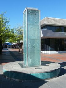
Photograph - Multiple, Maroondah City Council water fountain located in Melbourne Street, Ringwood in 2008. Opened on 13 March 1997, 2008
... Maroondah City Council water fountain located in Melbourne... water fountain located in Melbourne Street, Ringwood in 2008 ...Before Stage 5 of the expansion of Eastland and REALM.Digital photographs only -
 Ringwood and District Historical Society
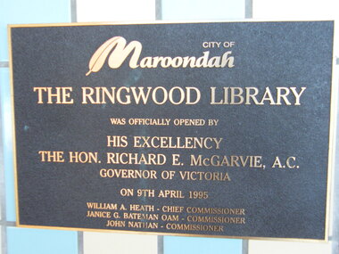
Photograph - Multiple, Ringwood Library located in Melbourne Street, Ringwood in 2008. Opened on 8 April 1995 by His Excellency The Hon. Richard E. McGarvie A.C, 2008
... Ringwood Library located in Melbourne Street, Ringwood in... located in Melbourne Street, Ringwood in 2008. Opened on 8 April ...Before Stage 5 of the expansion of Eastland and REALM.Digital photographs only -
 Ringwood and District Historical Society
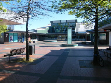
Photograph - Multiple, Melbourne Street, Ringwood in 2008, 2008
... Melbourne Street, Ringwood in 2008. ... of Eastland and REALM. Digital photographs only Melbourne Street ...Before Stage 5 of the expansion of Eastland and REALM.Digital photographs only -
 Ringwood and District Historical Society
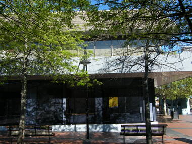
Photograph - Multiple, Shops in Melbourne Street, Ringwood in 2008, 2008
... Shops in Melbourne Street, Ringwood in 2008. ... Road Ringwood North melbourne Before Stage 5 of the expansion ...Before Stage 5 of the expansion of Eastland and REALM.Digital photographs only -
 Ringwood and District Historical Society
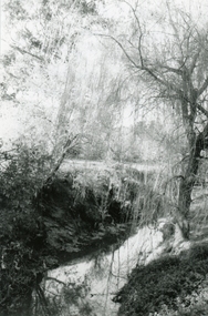
Photograph, Mullum Mullum Creek towards Ringwood Street, near old Melbourne Street off Miles Avenue, on 10th September 1989, 1989
... Melbourne Street off Miles Avenue, on 10th September 1989... Creek towards Ringwood Street, near old Melbourne Street off ...Digital photograph -
 Ringwood and District Historical Society
Photograph, North side of Maroondah Highway, Ringwood Shops east of Melbourne Street on 26th January, 1991
... Melbourne Street on 26th January, 1991... of Maroondah Highway, Ringwood Shops east of Melbourne Street on 26th ...Digital photograph -
 Eltham District Historical Society Inc
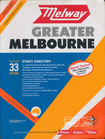
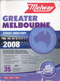
Book, Melway Publishing, Melway Greater Melbourne street directory : including Geelong, Phillip Island, Healesville, Kinglake, Gisborne, Lorne, Wallan, Bacchus Marsh Bellarine & Mornington Peninsulas; Edition 33, 2006, 2005
... Melway Greater Melbourne street directory : including... streets,roads,melbourne,map,melway Street directory with plastic ...Edition 33. 2006 Coloured detailed maps accessed by a street or location index. Cover: Totally revised and updated with over 1380 new street listings new maps covering Mount Duneed on the Bellarine Peninsula, Pakenham South and Rythdale. Detailed public transport routes - train, tram, bus, bicycle paths & shared road routes. Eastlink fully detailed new Craigieburn bypass GPS compatible WGS/MGA Grid Special feature: New Hierachy of Roads Street directory with plastic cover, coloured maps, 902 pagesstreets,roads,melbourne,map,melway -
 Eltham District Historical Society Inc
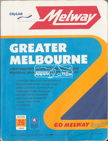
Book, Melway Greater Melbourne street directory : including Geelong, Phillip Island, Healesville, Bellarine & Mornington Peninsulas; Edition 26, 1999, 1999
... Melway Greater Melbourne street directory : including... melbourne streets roads melbourne maps melway Street directory ...Street directory with plastic cover, coloured maps, 772 pages 28 cm x 21.5 cm 1998streets, roads, melbourne, maps, melway -
 Eltham District Historical Society Inc
Book, Melway Greater Melbourne street directory 2008 : including Geelong, Phillip Island, Healesville, Kinglake, Gisborne, Lorne, Bacchus March, Wallan, Bellarine & Mornington Peninsulas; Edition 35, 2008, 2007
... Melway Greater Melbourne street directory 2008 : including... Hierachy of Roads streets,roads,melbourne,map,melway Street ...Edition 35. 2008 Coloured detailed maps accessed by a street or location index. Cover: Totally revised and updated with over 730 additional street listings, new maps extending the Gisbourne and Wallan areas. The most comprehensive public transport routes information - train, tram, bus, walking and bicycle tracks. Eastlink fully detailed, Victoria Racing Club, Flemington enlargement, GPS compatible WGS/MGA Grid displayed, This editon is available in LARGE PRINT format, new eway electronic street directory now available - www.melway.com.au Special feature: New Hierachy of Roads Street directory, coloured maps, indexes, 1201 pagesstreets,roads,melbourne,map,melway -
 Eltham District Historical Society Inc
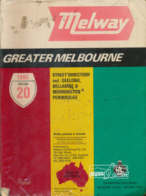
Book, Melway Publishing, Melway Greater Melbourne Street Directory, edition 20, 1990, 1990
... Melway Greater Melbourne Street Directory, edition 20, 1990... melbourne Coloured detailed maps accessed by a street or location ...Coloured detailed maps accessed by a street or location index.500 p. : col. maps ; Flexible cover edition with fitted clear plastic jacket.ISSN 03113957streets, roads, maps, melway -
 Eltham District Historical Society Inc
Book, Melway Great Melbourne street directory including Geelong, Phillip Island Healesville, Bellarine & Mornington Peninsulas, 1998
... Melway Great Melbourne street directory including Geelong... melbourne 25th edition. Coloured detailed maps accessed by a street ...25th edition. Coloured detailed maps accessed by a street or location index. Cover: (Includes) New Southbank map including Crown Complex, enlargements of Footscray and Kensington, bike paths, walking tracks & horse trails, latest public transport information, South east Australia tours maps, Vic Roads new route numbers, map of Australia1 atlas (22, 772 p.) : col. maps ; ISSN 03113957streets, maps, roads, melbourne -
 Eltham District Historical Society Inc
Book, Melway Publishing, Melway Greater Melbourne street directory : including Geelong, Phillip Island, Healesville, Bellarine & Mornington Peninsulas, 2002
... Melway Greater Melbourne street directory : including... melbourne Edition 29. Coloured detailed maps accessed by a street ...Edition 29. Coloured detailed maps accessed by a street or location index. Cover: 20 additional pages of new maps, extended coverage of Bellarine Peninsula, further coverage of Werribee South, Public Transport Information, latest official suburb boundaries, CBD "hook turn" intersections map, over 1200 new streets, 1 atlas (24, 886 p.) : col. maps ; ISSN 03113957streets, roads, melbourne, maps, melway -
 Ringwood and District Historical Society
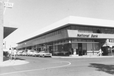
Photograph, National Bank Building, Melbourne Street, Ringwood 1973
... National Bank Building, Melbourne Street, Ringwood 1973.... National Bank Building, Melbourne Street, Ringwood 1973 Photograph ...Black and white photograph of National Bank building on corner Melbourne St and Civic Pl Ringwood.On Reverse: "3.4.73 On Site of Old Town Hall" 3rd April 1973 -
 Ringwood and District Historical Society
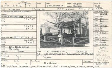
Document, Property profile for sale of house and land, 4 Melbourne Street, Ringwood, Victoria - 1960
... Property profile for sale of house and land, 4 Melbourne.... Property profile for sale of house and land, 4 Melbourne Street ...The house was owned by Mrs. Jessie White 4, Melbourne St. on the corner of Miles Ave. now both lost in the development of Eastland Shopping Centre.Details include map reference, dimensions of land and living space, picture of house, details of local services. Owner/Occupier Mr. Whiter. Agent J.B. Thomson & Co., 129 Springvale Road, Nunawading. -
 Ringwood and District Historical Society
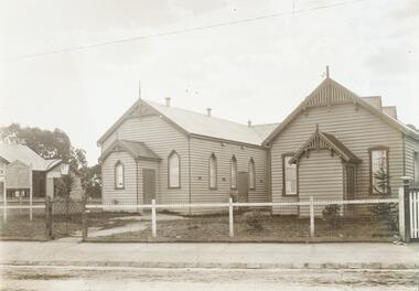
Photograph, Ringwood Methodist church and Sunday school c.1912, located on the corner of Main Street and Melbourne Street up until 1915
... on the corner of Main Street and Melbourne Street up until..., located on the corner of Main Street and Melbourne Street up until ...Written on backing sheet of one, "RWD Meth. Church and Sunday school, Main St. 1915. Cnr. Melbourne St." Other photograph in same sleeve states on back, "Methodist Church Ringwood. Cnr. Main St. and Melbourne St. Up to 1915" -
 Ringwood and District Historical Society
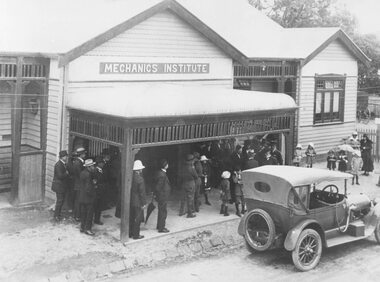
Photograph, Maroondah Highway Central, Ringwood. Mechanics Institute, Melbourne Street entrance - September, 1909
... , Melbourne Street entrance - September, 1909...., Ringwood. Mechanics Institute, Melbourne Street entrance ...Black and white photograph (3 copies- 1 original and 2 copies)Typed below Photograph: "Mechanics Institute - Melbourne St. South. (Now demolished) Image shows a wooden building with sign above veranda reading "Mechanics Institute". Groups of men and children standing outside with car parked on roadway in front of building. Official opening by Premier of Victoria, Mr. John Murray. -
 Ringwood and District Historical Society
Photograph, Maroondah Highway Central, Ringwood. Melbourne Street to Ringwood Street - 1974
... Maroondah Highway Central, Ringwood. Melbourne Street to... photograph Maroondah Highway Central, Ringwood. Melbourne Street ...Black and white photographWritten on rear of backing sheet: "Main St., Melbourne St. to Ringwood St., 1974." -
 Ringwood and District Historical Society
Photograph, Maroondah Highway Central, Ringwood. Shops on site of old Town Hall, corner of Melbourne Street, 1972
... Town Hall, corner of Melbourne Street, 1972.... Shops on site of old Town Hall, corner of Melbourne Street, 1972 ...Black and white photograph (2 copies) Written on rear of backing sheet: "Shops on site of old Town Hall. Cnr. Melbourne St. 1972" -
 Victorian Aboriginal Corporation for Languages
Book, Melway Publishing, Melway Greater Melbourne street directory : including Geelong, Phillip Island, Healesville, Kinglake, Gisborne, Lorne, Wallan, Bacchus Marsh, Bellarine &? Mornington Peninsulas, 2005
... Melway Greater Melbourne street directory : including... Street Brunswick melbourne maps Victorian street maps street ...Street directory including the wider area surrounding Melbourne.mapsmaps, victorian street maps, street directories, road maps -
Hume City Civic Collection
Print - Street Directory, Gregory"s Melbourne Street Directory, c1972
... Gregory"s Melbourne Street Directory... melbourne This street directory was published by Gregory's Guides ...This street directory was published by Gregory's Guides & Maps Pty Ltd of 142 Clarence Street, Sydney NSW in c1972. It was used by the donor's family for many years to navigate their way around Melbourne and the metropolitan area. A street directory enclosed in a black leather detachable cover with gold embossing of a car on the front cover.Gold embossed vintage car on front of detachable cover.joan houston, streets, roads, maps, street directory -
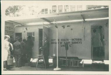 Department of Health and Human Services
Photograph, Mobile chest x-ray clinic van on site on Melbourne street, showing individuals queuing to undertake screening for tuberculosis. Photo is from a photograph album circa 1962
... Mobile chest x-ray clinic van on site on Melbourne street... clinic van on site on Melbourne street, showing individuals ...Black and white photograph -
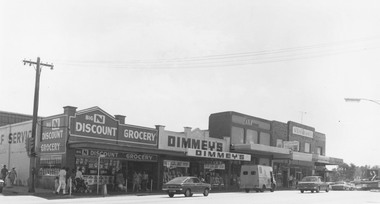 Ringwood and District Historical Society
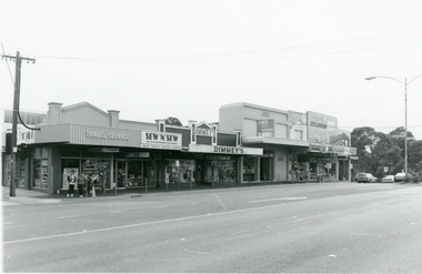
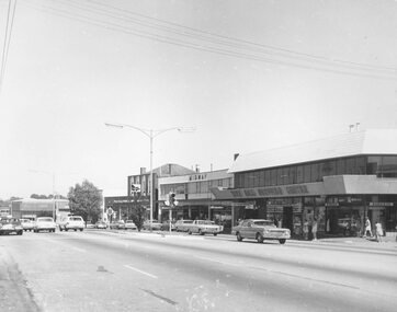
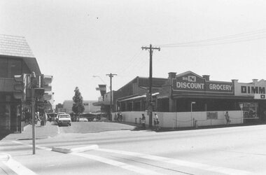
Photograph, Maroondah Highway Central, Ringwood. Shops on the north-east corner of Melbourne Street and Maroondah Highway, c.1970
... -east corner of Melbourne Street and Maroondah Highway, c.1970...., Ringwood. Shops on the north-east corner of Melbourne Street ...Black and white photographShops in photograph are 'Big N Discount Grocery, Dimmey's, ANZ Bank, Sound and Camera'. Safeway roof can be seen in the distance. -
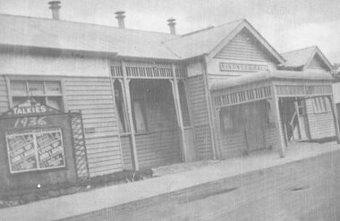 Ringwood and District Historical Society
Photograph, Maroondah Highway Central, Ringwood. Ringwood Hall fronting Melbourne Street, Ringwood - 1936
... Melbourne Street, Ringwood - 1936.... Melbourne Street, Ringwood - 1936. Photograph ...Taken 1936, advertising the Talkies, Melbourne St fronting, "look up and laugh"Written on backing sheet, "Ringwood Hall - later demolished and replaced by the Town Hall. Taken in 1936." Advertising board at front reads- Talkies, 1936. "Look Up and Laugh". -
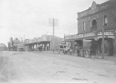 Ringwood and District Historical Society
Photograph, Maroondah Highway Central, Ringwood. Coffee Palace and shops along Main Street between Adelaide Street and Melbourne Street. c1920's
... shops along Main Street between Adelaide Street and Melbourne... Main Street between Adelaide Street and Melbourne Street. c1920 ...Black and white photographWritten on back of photograph: "Land values - Main Street, Ringwood - land worth £50 pounds a foot." Image is taken from a land sale brochure and shows cars and horse drawn vehicles parked in front of buildings. -
 Ringwood and District Historical Society
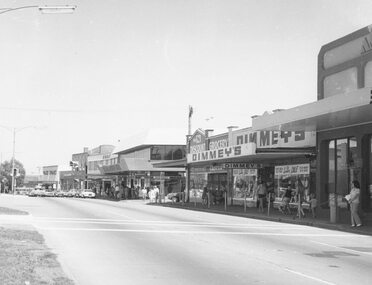
Photograph, Maroondah Highway Central, Ringwood. Melbourne Street entrance, 1975
... Maroondah Highway Central, Ringwood. Melbourne Street... Highway Central, Ringwood. Melbourne Street entrance, 1975 ...Black and white photographWritten on back of photograph: "Norman's Grocery shop, re-built January 1975." -
 Ringwood and District Historical Society
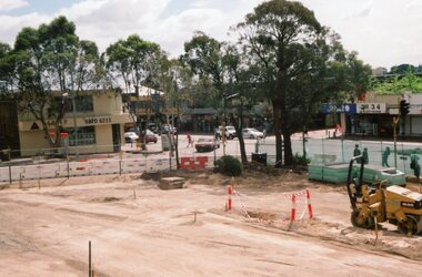
Photograph, Ringwood Railway Precinct in 2009, facing west towards former CE Carter premises and Melbourne Street, showing demolished corner shops
... former CE Carter premises and Melbourne Street, showing... former CE Carter premises and Melbourne Street, showing ... -
 Ringwood and District Historical Society
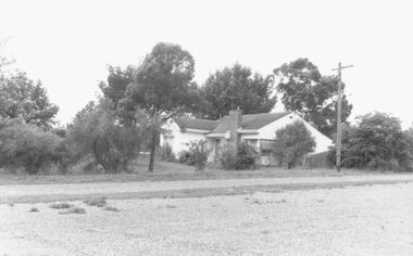
Photograph, Last house in Miles Avenue. On the east corner of Melbourne Street. Ringwood, 1987
... Melbourne Street. Ringwood, 1987.... house in Miles Avenue. On the east corner of Melbourne Street ...Black and white photograph of house in Miles Avenue. -
 Ringwood and District Historical Society
Photograph, Ringwood Railway Precinct circa 2008, showing shops on Maroondah Highway, including Dimmey's and Melbourne Street
... Maroondah Highway, including Dimmey's and Melbourne Street... on Maroondah Highway, including Dimmey's and Melbourne Street ... -
Port Melbourne Historical & Preservation Society
Photograph - Bay Street, Port Melbourne, Rose Stereograph Co, 1917
... Bay Street, Port Melbourne... Street Port Melbourne in 1917. Photo taken near intersection... Melbourne Town Hall 333 Bay Street Port Melbourne melbourne built ...STATE LIBRARY acknowledgement required. Image of Bay Street Port Melbourne in 1917. Photo taken near intersection of Bay and Liardet Streets and looks towards the Bay. Shows Port Melbourne Theatre on left and Burns Bros on right and cable trams. Used in the PMHPS calendar for 2015 (May)Image H32492/4606. Rose postcard series 3334built environment - commercial, transport - tramways, recreation, burns brothers - grocers, port melbourne theatre, bay street -
Port Melbourne Historical & Preservation Society
Photograph - Port Melbourne Library, Liardet Street, Douglas Smallpage, 1970s
... Port Melbourne Library, Liardet Street... Melbourne Town Hall 333 Bay Street Port Melbourne melbourne Local ...B&W photos of various locations in Port Melbourne c1950s Port Melbourne Library in Liardet St. (Demolished in 1988)Several have descriptions of locations in pencil on rear of photoslocal government - city of port melbourne, port melbourne library, liardet street