Showing 527 items
matching panorama
-
 Ballarat Heritage Services
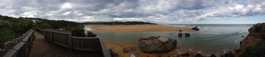
Digital photographs, L.J. Gervasoni, Hopkins River Mouth - panorama, c2010 - 2017
Colour photograph of the mouth of the Hopkins River, Warrnambool.hopkins river, mouth, point ritchie, bluehole, warrnambool, coast, coastal, beach, seascape, coastal geomorphology, pano -
 Ballarat Heritage Services
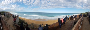
Digital photographs, Logans Beach Whalewatchers Panorama, c2010
Logan's Beach is known as a whale watching site. Colour panoramic photograph of the coast at Logan's beach, Warrnambool.warrnambool, coast, coastal, beach, seascape, whale watching, platform, logans beach -
 Ballarat Heritage Services
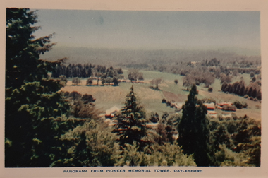
Photograph, Nucolorvue, Panorama from the Pioneed Memorial Tower, Daylesford, 1957
Daylesford is a tourist town in Central Victorian, known for its mineral water springs.Central Springs DaylesfordDaylesford, Victoria, Australia This famous holiday resort is famous for its up-to-date facilities, as well as for its natural attractions. The mineral Springs are renowned for their high medicinal elements. The visitor finds ample to amuse, in excellent fishing, boating, Boating, Swimming, golfing, hiking and riding. The district provides a wide range of typical Australian bush scenery, and the altitude of 2,000 feet above sea level as a tonic effect on all. Daylesford has modern hotels, guest houses, shops and places of amusement, also many other places of interest within short travelling distance. Bendigo, 50 miles, Ballara 30 miles, and Melbourne 75 miles, bring Daylesford within easy reach of many parts of Victoria. daylesford, wombat gardens, wombat hill gardens, daylesford pioneer memorial tower, landscape -
 Inverloch Historical Society
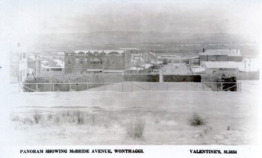
004269 - Postcard - Panorama showing McBride Avenue, Wonthaggi
-
 Moorabbin Air Museum
Magazine (Item) - ANSETT in flight magazine - "Panorama" - Commemorative Souvenir 1936-1986 [3 Copies]
-
Moorabbin Air Museum
Souvenir (Item) - Ansett - souvenirs & Panorama magazine & Timetables
-
Moorabbin Air Museum
Magazine (Item) - Ansett Panorama magazines Oct 87 & 50th Anniversary edition
-
Moorabbin Air Museum
Magazine (Item) - Panorama The Journal OI Ansett -ANA Vol.9 No.4 April-May 1967
-
Moorabbin Air Museum
Newspaper (Item) - Panorama Vol.8 No.10 October 1966
-
Moorabbin Air Museum
Newspaper (Item) - Panorama Vol.9 No.2 February 1967
-
Moorabbin Air Museum
Journal (Item) - Panorama The Journal of Ansett Airline of Australia Vol 14. No.11 November 1972
-
Moorabbin Air Museum
Journal (Item) - Panorama Ansett Inflight Magazine January 1989
-
Moorabbin Air Museum
Journal (Item) - Panorama in-flight with Ansett No.9 Sep/Oct 1982
-
Moorabbin Air Museum
Journal (Item) - Panorama Ansett Inflight Magazine No.44 February 1986
-
Moorabbin Air Museum
Journal (Item) - Panorama Ansett Inflight Magazine No.45 March 1986
-
Moorabbin Air Museum
Journal (Item) - Panorama Ansett Inflight Magazine April 1989
-
 Ballarat Tramway Museum
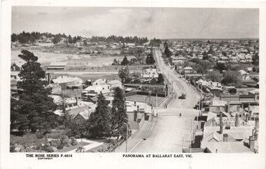
Postcard, Rose Stereograph Co, "Panorama at Ballarat East Vic", c1916
Photo looks west from the Ballarat Fire Station (East) tower, and has a good view looking along Barkly St. Shows the crossing loop between Eastwood and Main St with one tram in the view. Wal has dated the photo as 1914 in his album notes. On rear Wal Jack has written "Looking up Barkly St towards Mt Pleasant. Photo taken from Ballarat Fire Station about 1914-1916 period. Old type tram from Mt Pleasant about to turn into Main St. Note old passing loop behind tram. Loop removed to top of rise in centre background. Old Ballarat East Gardens on left and council yards, showing big tin shed in centre of picture. Locality much altered today." See item 5127 for a digital image.Yields information about the buildings and scene looking west from the Fire Station tower along Barkly St. East BallaratPostcard Black and white - Rose Series No P4614, Divided back. No publishers details on rear.See image 2 for Wal Jack's notes.tramways, trams, esco, ballarat east, barkly st -
Moorabbin Air Museum
Magazine (Item) - "Panorama" inflight magazine of Ansett Australia May 94, with picture of woman in ANA uniform
-
 Ballarat Tramway Museum
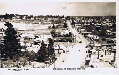
Photograph - Digital image, Rose Stereograph Co, "Panorama at Ballarat East Vic", c1914
Photo looks west from the Ballarat Fire Station (East) tower, and has a good view looking along Barkly St. Shows the crossing loop between Eastwood and Main St with one tram in the view. Wal has dated the photo as 1914 in his album notes. See item 8243 for an actual postcard. Yields information the buildings, buildings and scene looking west from the Fire Station tower along Barkly St. East BallaratDigital image of a postcard from an album compiled by Wal Jack, loaned to the Museum. The Rose Series Postcard No. P 4614. For rear of postcard - see second image.trams, tramways, esco, ballarat east, barkly st -
 Kew Historical Society Inc
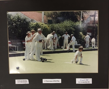
Photograph - Framed Photograph, Kew Bowling Club: A Panorama of Bowling 1990, 1990
Sports Clubs in Kew in the final decades of the 19th century and in the early 20th century were often umbrella organisations with facilities for a number of sports. Typically in Kew, this included teams in lawn bowls, tennis and croquet. The Kew Bowling Club was formed in 1880 while the privately owned Auburn Heights Recreation Club was opened in 1904. By 1998, the two Clubs decided to amalgamate at the Auburn Heights site in Barkers Road, forming the Kew Heights Sports Club. The combined club was itself taken over by the Melbourne Cricket Club in 2012 becoming MCC Kew Sports Club. In 2017 MCC Kew closed and its landholding was subsequently sold to Carey Baptist Grammar School. Both the Kew and Auburn Heights Clubs assembled important collections. These historically significant and large collections were donated to the Society in 2020. The collections include manuscripts, pictures, trophies, plans, honour boards etc. References Barnard FGA 1910, 'Sports and Pastimes' in Jubilee History of Kew Victoria: Its origin & progress 1803-1910. Nixon NV 1980, The History of the Kew Bowling Club 1880-1980. Reeve S 2012, City of Boroondara: Thematic Environmental History, p.216.The combined collections of the four sporting clubs making up the collection number hundreds of items that are historically significant locally. They are also significant to the sporting history of the greater Melbourne area and to the sports of lawn bowls and tennis in Australia in the 19th and 20th centuries. The collection illuminates two of the Victorian historic themes - 'Building community life' through forming community organisations and 'Shaping cultural and creative life' by participating in sport and recreation.Photograph, framed with a paper mount, and labelled. [The item is part of the large historic Kew Bowling Club collection (1880-1988) gifted to the Kew Historical Society in 2020].kew bowling club - wellington street - kew (vic), clubs - lawn bowls - kew (vic) -
 Kew Historical Society Inc
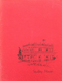
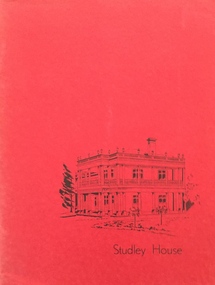
Booklet - Catalogue, Xavier College, Panorama of Australian Painting: 1818-1968, 1968
This work forms part of the collection assembled by the historian Dorothy Rogers, that was donated to the Kew Historical Society by her son John Rogers in 2015. The manuscripts, photographs, maps, and documents were sourced by her from both family and local collections or produced as references for her print publications. Many were directly used by Rogers in writing ‘Lovely Old Homes of Kew’ (1961) and 'A History of Kew' (1973), or the numerous articles on local history that she produced for suburban newspapers. Most of the photographs in the collection include detailed annotations in her hand. The Rogers Collection provides a comprehensive insight into the working habits of a historian in the 1960s and 1970s. Together it forms the largest privately-donated collection within the archives of the Kew Historical Society.A catalogue for an exhibition of Australian Art (1818-1968) at Studley House (Xavier Preparatory School) in 1968. The catalogue includes artist biographies and lists works exhibited. The foreword on the history of Studley House is written by Dorothy Rogersxavier college, australian art, dorothy rogers, art catalogues -
 Kew Historical Society Inc
Booklet - Catalogue, Xavier College, Panorama of Australian Painting: 1818-1968, 1968
This work forms part of the collection assembled by the historian Dorothy Rogers, that was donated to the Kew Historical Society by her son John Rogers in 2015. The manuscripts, photographs, maps, and documents were sourced by her from both family and local collections or produced as references for her print publications. Many were directly used by Rogers in writing ‘Lovely Old Homes of Kew’ (1961) and 'A History of Kew' (1973), or the numerous articles on local history that she produced for suburban newspapers. Most of the photographs in the collection include detailed annotations in her hand.The Rogers Collection provides a comprehensive insight into the working habits of a historian in the 1960s and 1970s. Together it forms the largest privately-donated collection within the archives of the Kew Historical Society.A catalogue for an exhibition of Australian Art (1818-1968) at Studley House (Xavier Preparatory School) in 1968. The catalogue includes artist biographies and lists works exhibited. The foreword on the history of Studley House is written by Dorothy Rogersaustralian art, xavier college -
Maldon Brass Band Inc.
Sheet Music, A PANORAMA OF FAMOUS SONG
-
 Stawell Historical Society Inc
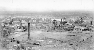
Photograph, Panorama Of Stawell from Big Hill looking North West 1878 Mines Visible
On very left behind the winding engine shed in the foreground is the South Cross Mines No8 & No9. The next mine to the right not counting the Whims is the Crown Cross United Mine with curved tramway. Tyne Reefing Company is barely visible at centre of image in front of left end of settling dam. The Great Northern is centre right of image, Extended Cross Reef Mine, then Oriental Mine, the Grant Lamont Battery and two Pleasant Creek Cross Reef Poppet Heads.Scotchmans United Quarts Mining Company 1878Victorian Views. C. Herbert, Photo. Stawell 1878stawell mining -
 Stawell Historical Society Inc
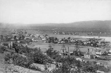
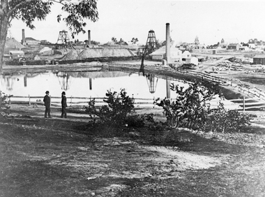
Photograph, Panorama of Stawell Township with Poppet heads & Government Dam, later No2 Reservoir at centre of photo1878
Poppet heads and Government Dam later No2 Reservoir at centre of photo with Black Ranges in background. Stawell East State School on left, Wimmera Battery (also known as Cobb's Battery) on right of photo. 1878. Mr Chaponnel was an Engine Driver on the Battery. No2 West Scotchmans mine on left started in 1873No2 Reservoir in centre of photograph behind two prominent poppet heads. Black Range in right rear of photo. Victorian Views. C. Herbert, Photo. Stawell. 1878stawell mining -
 Stawell Historical Society Inc
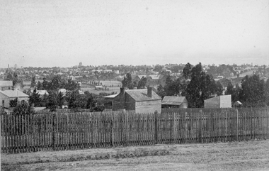
Photograph, Panorama of Town from Church Hill or Stone Street area 1880
Part of Town from Church Hill or Stone Street area 1880. Stawell 502 in centre of image.stawell -
 Stawell Historical Society Inc
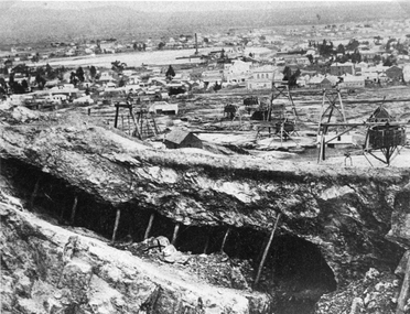
Photograph, Panorama of Mining Scene from Big Hill with the Open cut in foreground
Mining Scene from Big Hill. Open cut in fore ground with support timbers. Whims and poppet heads. Shows back of New Court House in Patrick Street. The flat area in distance is St Georges Crushing Battery settling Dam.Open Cut with supporting timbers in foreground, Various poppet Heads at centre of image. Wimmera Crushing Mill settling dam in distance. Rear of new Court House visiblestawell mining -
 Stawell Historical Society Inc
Photograph, The Pleasant Creek Cross Reef No1 Shaft Panorama of a Mining Scene in the Duke Sands area c1875
Mining Scene Duke Sands area c1875 Behind the tree on left is Extended Cross Mine and on the right is the Oriental Mine. In the centre is the North Cross Mine No1 shaft. In the foreground is one of the Moonlight dams. St Peters Lutheran Church in Scallan Street can be seen on the right horizon. Two mines and workings on other side of Moonies settling dam. Two Gentlemen lower left cornerstawell mining -
 Stawell Historical Society Inc
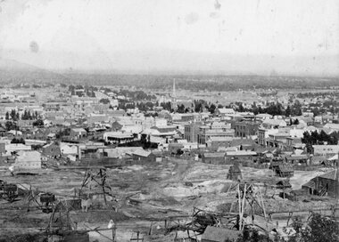
Photograph, Panorama of Stawell from Big Hill looking west with Main Street visible & mining in foreground 1872
Stawell from Big Hill looking west with Main Street visible and with mining in foreground 1872stawell -
 Stawell Historical Society Inc
Photograph, Panorama of Stawell from Big Hill showing Mining & Stawell 1972 from same location -- Christmas Cards with 2 Photos
Christmas Card with Photos of Stawell from Big Hill showing Mining 1872 & Stawell 1972 from same location View overlooking Main Street. St Matthews Church spire at centre of image.stawell