Showing 99 items matching " point nepean road"
-
 Whitehorse Historical Society Inc.
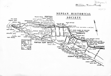
document - Map, Point Nepean, 1969
... Mitcham melbourne point nepean victoria nepean historical society ...Map of Point Nepean showing historical sites, issued by the Nepean Historical Society, 1969.point nepean, victoria, nepean historical society -
 City of Kingston
Photograph - Colour, c. 1993
Patterson Lakes is a suburb in the City of Kingston that is built one kilometre upstream of the mouth of the Patterson River. The area is bordered by the Patterson River and Eel Race Drain which enters the Kananook Creek. The suburb consists predominantly of newer housing developments and the tidal canal system of the development joins Port Phillip Bay.Patterson Lakes and the Kananook Creek were previously part of the extensive Carrum Carrum Swamp. The area was once a source of fish and eels for the Mayone-Bulluk clan of the Bunurong people. Over time the area was drained and in 1973 investigations commenced into the development of a unique residential area that would be built adjacent to canals and waterways. It was originally proposed to be known as "Gladesville". The development would give the suburb's homeowners access to Port Phillip Bay "from their back door". Circa 1974, the area was rezoned from rural to residential and named Patterson Lakes. Development has been continuous since the 1970s with construction of residential housing, schools, shopping centres, marinas, a hotel and library.Laminated colour aerial photograph of the Carrum and Patterson Lakes region within City of Kingston. This 1993 image includes Patterson River Secondary College, Roy Dore Reserve, Kananook Creek and Nepean Highway. The railway line can be seen as it veers inland from Eel Race Road, Seaford. The section of Palm Beach Drive, Curlew Point Drive, Snapper Point Drive, Clipper Island and Myola Street in Patterson Lakes appears to be a recent development with many spare blocks and new houses under construction.patterson lakes, seaford, kananook creek, carrum carrum swamp, canals and waterways -
 City of Kingston
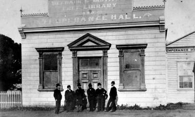
Photograph - Black and white, Percy Fairlam, Mechanics Institute and Temperance Hall, Cheltenham, c.1910
... of the land where Charman Road joined Point Nepean Road ...The Institute movement came to Melbourne in 1839 with the establishment of the Melbourne Mechanics’ Institute later known as the Melbourne Athenaeum. Adopting the principles of self help, social improvement and the recognition of the importance of useful knowledge, it maintained a library, a reading room and an art gallery, while also establishing classes and lectures in a variety of fields. Various dates have been suggested for the founding of the Cheltenham Mechanics’ Institute with the range being somewhere between 1853 and 1856. The first Institute building erected on the tip of the land where Charman Road joined Point Nepean Road was of weatherboard construction. It consisted of a small hall, a reading room and a library. Later it was realized that the building was inadequate for community functions that attracted a large number of participants; consequently additions and modifications were needed. The Shire Council in 1888 voted £10 to the building fund but stipulated that the money would only be paid when the new building was commenced. Major contributors to the fund were the temperance societies who were regular users of the Institute’s facilities. As a result of their contributions the building was named Mechanics’ Institute Free Library and Temperance Hall with this title being proudly painted on its façade in ‘gold letters shaded with blue’.Black and white image of a group of six men dressed in suits and wearing hats, standing at the front entrance of the Mechanics Institute, Free Library and Temperance Hall, Cheltenham -
 City of Kingston
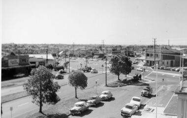
Photograph - Digital image, Black and white, Roads - Junction of Nepean Highway and South Road, c. 1950
Junction of Nepean Highway and South Road, Moorabbin - Moorabbin Hotel on right. Shops in centre demolished for road widening in 1980'sBlack and white image of Nepean Highway and South Road junction point of view from Kingston Town HallPrinted in black text a round white sticker: 234 Handwritten in red ink 80% Yellow post it note written in blue ink: CHAP 7 234 / - Nepean Hwy + South Roadnepean highway, south road, moorabbin, moorabbin hotel -
 Melbourne Tram Museum
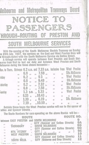
Document - Photocopy, Melbourne & Metropolitan Tramways Board (MMTB), "Notice to Passengers - Through routing of Preston and South Melbourne Services", Originals - 1937
... Cemetery tramway via Hawthorn Road, to Point Nepean Rd, East... - Extension of Brighton Cemetery tramway via Hawthorn Road, to Point ...Set of three photocopied notices onto foolscap, heat sensitive paper, c1937, with details of alterations due to revised or new tram routes. All signed S. M. Richardson as Manager. .1 - "Notice to Passengers - Through routing of Preston and South Melbourne Services" Gives new route numbers. Dated 10th July 1937. .2 - "Notice to Passengers - Extension of Brighton Cemetery tramway via Hawthorn Road, to Point Nepean Rd, East Brighton" - November 1937, part of copy missing on left hand side. Opening date to be 5th December 1937. .3 - "Notice to Passengers - Collingwood cable tramway bus service on Sunday mornings", gives details of bus times and frequency - and commencement times for the cable trams. Dated 3rd November 1937.trams, tramways, preston, south melbourne, east brighton, hawthorn rd, opening, routes, buses, cable trams, collingwood -
 Chelsea & District Historical Society Inc
Photograph - Patterson River, Rail and Road Bridge, c 1912
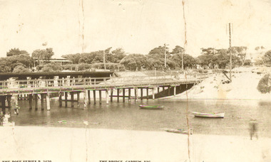
... Sepia photo of the road bridge (Point Nepean / Nepean... Bridge Carrum Bridge Sepia photo of the road bridge (Point Nepean ...The first bridge over the river was built in the early 1880's, prior to this it was a pontoon bridge.Sepia photo of the road bridge (Point Nepean / Nepean Highway) and rail bridge, near the mouth of the Patterson River., Carrum patterson river, road bridge, rail bridge, chelsea, transport, patterson river bridge, carrum bridge -
 Chelsea & District Historical Society Inc
Photograph - Patterson River, Rail and Road Bridge
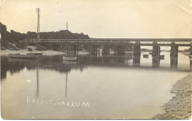
... Black and white photo of the road bridge (Point Nepean... (Point Nepean / Nepean Highway) and rail bridge, near the mouth ...The first bridge over the river was built in the early 1880's, prior to this it was a pontoon bridge.Black and white photo of the road bridge (Point Nepean / Nepean Highway) and rail bridge, near the mouth of the Patterson River. Taken from the mouth of the river.patterson river, road bridge, rail bridge, chelsea, transport, patterson river bridge, carrum bridge -
 Chelsea & District Historical Society Inc
Photograph - Patterson River, Rail and Road Bridge, c 1910
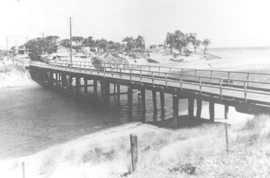
... Black and white photo of the wooden road bridge (Point... bridge (Point Nepean / Nepean Highway), over Patterson River ...The first bridge over the river was built in the early 1880's, prior to this it was a pontoon bridge.Black and white photo of the wooden road bridge (Point Nepean / Nepean Highway), over Patterson River, Carrum near the mouth of the river. patterson river, road bridge, rail bridge, chelsea, transport, patterson river bridge, carrum bridge -
 Chelsea & District Historical Society Inc
Photograph - Patterson River, Temporary and Old Bridge, c 1927
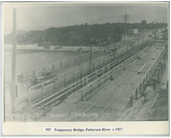
... Black and white photo of the old wooden road bridge (Point..., Carrum Black and white photo of the old wooden road bridge (Point ...The first bridge over the river was built in the early 1880's, prior to this it was a pontoon bridge. In 1927 the construction of a concrete bridge was undertaken.Black and white photo of the old wooden road bridge (Point Nepean / Nepean Highway), and a temporary bridge over Patterson River, Carrum near the mouth of the river. Cars using the old bridge. Rowing boats on shore. Temporary and old bridge, Carrumpatterson river, road bridge, rail bridge, chelsea, transport, patterson river bridge, carrum bridge, temporary bridge, cars