Showing 1811 items
matching region
-
 Brimbank City Council
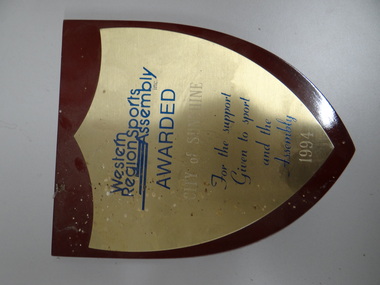
Plaque, Western REgion Sports Assembly, 1994
Wooden plaque in the shape of a shield -
 Brimbank City Council
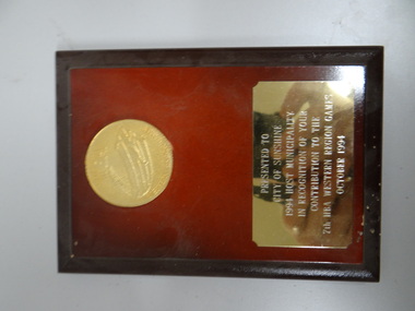
Plaque, HBA Wetsern Region Games, 1994
small wooden plaque -
 Brimbank City Council
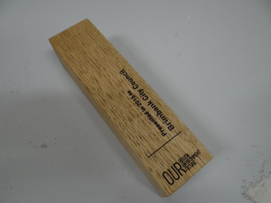
Wooden Block, Our Region Enviroment Future
-
 Brimbank City Council
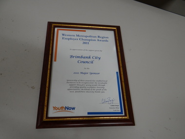
Framed Award Certificate, Western Metropolitan Region Employer Awards 2011, 2011
-
 Southern Sherbrooke Historical Society Inc.
Book, "The Conservation of Sites and Structures of Historical and Archaelogical Significance in the Upper Yarra Valley and Dandenong Ranges Region", 1978
The work in two volumes, "Vol.1" containing the report with the exception of Chapter 5, which is the list and description of sites, and an unnumbered volume containing the entire report, was cancelled from the Belgrave branch of the Eastern Regional LibraThe publication, referred to as the Tansley Report, was prepared in 1978 as part of a Bachelor of Town & Regional Planning degree. It contains sections on conservation, pre-history and history of the area, and a list of significant sites. This is a photocopy of the original report. -
 Beechworth Honey Archive
Publication, Establishing the disease status of the Asian honeybee in the Cairns region. (Roberts, John and Anderson, Denis). Canberra, 2013, 2013
15 pages, illustrated. -
 Beechworth Honey Archive
Publication, Mite pests of honey bees in the Asia-Pacific region. (Australian Centre for International Agricultural Research). Canberra, 2007, 2007
34 pages, illustrated. -
 Beechworth Honey Archive
Publication, Eucalypts of the Sydney region: a bushwalker's guide (Leonard, G.), Sydney, 2007, 2007
-
 Beechworth Honey Archive
Publication, Native bees of the Sydney region: a field guide (Dollin, A. et al), North Richmond, 2000, 2000
-
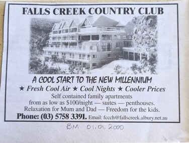 Falls Creek Historical Society
Article - Region Boasts Premier Skifields
A newspaper article from the Border Morning Mail on 01/01/2000. It describes developments on Victoria's skifields including Falls Creek, Mount Hotham and Mount Bogong.A newspaper article and advertisement for Victoria's skifields and the Falls Creek Country ClubA newspaper article from the Border Morning Mail on 01/01/2000. It describes developments on Victoria's skifields including Falls Creek, Mount Hotham and Mount Bogong.victoria's skifields, falls creek 2000, falls creek country club -
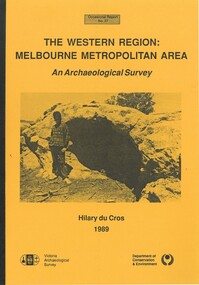 Bacchus Marsh & District Historical Society
Book, The Western Region: Melbourne Metropolitan Area: An Archaeological Survey
This study aimed to locate and document Aboriginal archaeological sites in the western region of Melbourne. This area was defined by the study as extending out from the western suburbs of Melbourne to the Brisbane Ranges and north beyond Bacchus Marsh. The specific aim of the study was to investigate the Aboriginal archaeology of the Western Plains area in the vicinity west of Melbourne. The Bacchus Marsh, Melton and Werribee shire boundaries of the time defined the areas of the study. The study contains extensive lists of the types of artifacts found the the locations where they were found.Soft cover foolscap size book. 96 pages with b & w illustrations, images and maps (some folded). Part of Occasional reports series (Victoria Archaeological Survey) ; No. 27. Published by Department of Conservation and Environment, Melbourne, 1990. Author, Hilary Du Cros. BMDHS Loc. AR/SU5This study aimed to locate and document Aboriginal archaeological sites in the western region of Melbourne. This area was defined by the study as extending out from the western suburbs of Melbourne to the Brisbane Ranges and north beyond Bacchus Marsh. The specific aim of the study was to investigate the Aboriginal archaeology of the Western Plains area in the vicinity west of Melbourne. The Bacchus Marsh, Melton and Werribee shire boundaries of the time defined the areas of the study. The study contains extensive lists of the types of artifacts found the the locations where they were found. aboriginal australians victoria western plains, aboriginal artifacts, archaelogical sites victoria western plains, aboriginal artifacts bacchus marsh region -
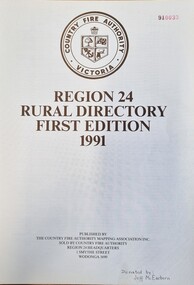 Wodonga & District Historical Society Inc
Booklet - CFA Region 24 Rural Directory, Country Fire Authority Mapping Association, 1991
This publication was been prepared to meet the need in the rural community for a "Rural Directory". Its primary purpose was to decrease the time taken by fire brigades and other services responding to emergency calls. It provides maps of the whole region as well as selected towns. It also includes a localities index, map legends and a road index.An A4 sized directory of 119 pages including an index and maps. The volume has black plastic spiral binding and laminate cover.This publication was been prepared to meet the need in the rural community for a "Rural Directory". Its primary purpose was to decrease the time taken by fire brigades and other services responding to emergency calls. It provides maps of the whole region as well as selected towns. It also includes a localities index, map legends and a road index.victorian country fire authority, fire protection regions, cfa region 24 -
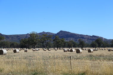 Victorian Farmers Federation
Photograph, Lisa Gervasoni, Hay bales in the Grampians Region, 27/01/2017
Hay bales are a key food in a grazing livestock production system. The paddock shows the co-existence of native vegetation which provides cover for livestock. Digital photographfarming, hay, native vegetation, agriculture, farm, western victoria -
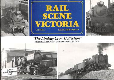 Victorian Railway History Library
Book, Sargent, John, Rail Scene Victoria The Lindsay Crow Collection: Victorian Railways - North Central Region, 1992
A pictorial history of broad gauge 5'3" steam locomotives in the North Central region of Victoria from the collection of Lindsay Crowill, p103.non-fictionA pictorial history of broad gauge 5'3" steam locomotives in the North Central region of Victoria from the collection of Lindsay Crowsteam locomotives - victoria- history, railroad operations - victoria -
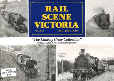 Victorian Railway History Library
Book, Sargent, John, Rail Scene Victoria The Lindsay Crow Collection: Victorian Railways - Gippsland Region, 1992
A pictorial history of broad gauge 5'3" steam locomotives in the Gippsland region of Victoria from the collection of Lindsay Crowill, p104.non-fictionA pictorial history of broad gauge 5'3" steam locomotives in the Gippsland region of Victoria from the collection of Lindsay Crowsteam locomotives - victoria- history, railroad operations - victoria -
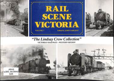 Victorian Railway History Library
Book, Sargent, John, Rail Scene Victoria The Lindsay Crow Collection: Victorian Railways - Western Region, 1992
A pictorial history of broad gauge 5'3" steam locomotives in the Western region of Victoria from the collection of Lindsay Crowill, p103.non-fictionA pictorial history of broad gauge 5'3" steam locomotives in the Western region of Victoria from the collection of Lindsay Crowsteam locomotives - victoria- history, railroad operations - victoria -
 Bacchus Marsh & District Historical Society
Building plans and designs for various hotels in the Bacchus Marsh region c.1930s-2000s
Plans in this collection include hotels and premises licensed to sell liquor in Ballan, Lal Lal, Myrniong, Spargo Creek and Wallace.Architecture plans and drawings on single sheets of paper mostly ranging in size from A3 to A2. BMDHS Location: AR/R5/S2hotels bacchus marsh region, hotels designs and plans, hotels architectural plans, hotels building plans -
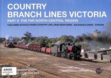 Victorian Railway History Library
Book, Sargent, John, Country Branch Lines Victoria Part 9 The Far North-Central Region, 2015
A photographic profile by Neville Gee of the Victorian country branch lines to Toolamba-Echuca cross-country line, Deniliquin (NSW), Balranald (NSW) & Cohuna.ill, maps, p.56.non-fictionA photographic profile by Neville Gee of the Victorian country branch lines to Toolamba-Echuca cross-country line, Deniliquin (NSW), Balranald (NSW) & Cohuna.photography - neville gee, railroads -- australia -- trains -- pictorial works -
 Bacchus Marsh & District Historical Society
Map, Bacchus Marsh Region Parish Plans: Folded set of maps
Set of Victorian Lands Department Parish Plans covering the township of Bacchus Marsh and surrounding districts. Folded. BMDHS Location: AR/SU27/D2: Map Drawersmaps bacchus marsh region, bacchus marsh victoria maps, interim record -
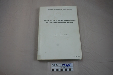 Emerald Museum & Nobelius Heritage Park
Book, Sites of Zoological Significance in the Westernport Region, 1984
Zoological Significance. The report contains the results of a survey of the vertebrate fauna of the Westernport catchment and a search of relevant literature, conducted between June 1979 and December 1981.White soft cover thick book, about A4 size. Prepared by the national Museum of Victoria for The Environmental Studies Division, Ministry of Conservation, Victoria 1984. -
Lakes Entrance Historical Society
Book, Synan Peter, Secrets of Ghost Towns of the High Country featuring 50 Ghost Towns in and around Victorias Alpine Region, 1989
A history of the Gippsland Lakes Victoria as a transport system v for trade within the Lakes and River systems and coastal and interstate trade.ships and shipping, land settlement, waterways -
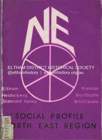 Eltham District Historical Society Inc
Book, North Eastern Suburbs Family and Community Services Regional Consultative Council, Social Profile North East Region, January 1985
Comprehensive statistical overview of Melbourne's north east region. The profile draws on census data for 1976 and 1981. Local Government summaries for the local government areas of Diamond Valley, Eltham, Heidelberg, Northcote, Preston and Whittlesea. Sections include demographic profiles (including family type and migrant populations), workforce, housing, education, support services, children's services, transport, recreation and leisure facilities, local government authorities, and local government area profile summaries.non-fictionComprehensive statistical overview of Melbourne's north east region. The profile draws on census data for 1976 and 1981. Local Government summaries for the local government areas of Diamond Valley, Eltham, Heidelberg, Northcote, Preston and Whittlesea. Sections include demographic profiles (including family type and migrant populations), workforce, housing, education, support services, children's services, transport, recreation and leisure facilities, local government authorities, and local government area profile summaries.population, social profile, social service, demographics -
Lakes Entrance Historical Society
Book, East Gippsland Regional Planning Committee, Sites of Historical Significance in the East Gippsland Region, 1980
Details of historical sites with comments about the money raising activities. History of construction..historic sites, charities, architecture -
Lakes Entrance Historical Society
Book, Central Planning Authority, Victoria, Resources Survey East Gippsland Region, 1954
A review of the physical, economic, and public resources of East Gippsland, Victoria.primary industry -
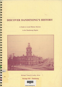 Narre Warren and District Family History Group
Book, Michael Tonta, Discover Dandenong's History: a guide to local history sources in the Dandenong Region, 1992
A guide to local history sources of the Dandenong region12 p.; 30 cmnon-fictionA guide to local history sources of the Dandenong regiondandenong (vic.), dandenong (vic.) - history -
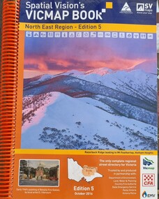 Wodonga & District Historical Society Inc
Book - Spatial Vision's VICMAP BOOK 2016 - Northeast Region, Spatial Vision Innovations Pty Ltd, 2016
This edition of Spatial Vision's VicMap Book North East Region was published in October 2016 and provides detailed topographic maps for the region. It was used by emergency services and various agencies, including the Country Fire Authority (CFA). It covers areas including Wodonga, Albury, Wangaratta, and beyond, including national parks and recreation areas. Text on the cover states that the volume is "Trusted by and produced in partnership with: Department of Environment, Land, Water & Planning, Country Fire Authority, State Emergency Service, Parks Victoria, Victoria Police".A spiral bound volume of 409 pages including colour topographic maps and illustrations of North East Victoria. The cover features a colour photo of Razorback Ridge leading to Mount Feathertop, Hotham Heights, Victoria. It also features an index map inside the front cover, a legend, road index, and locality index.This edition of Spatial Vision's VicMap Book North East Region was published in October 2016 and provides detailed topographic maps for the region. It was used by emergency services and various agencies, including the Country Fire Authority (CFA). It covers areas including Wodonga, Albury, Wangaratta, and beyond, including national parks and recreation areas. Text on the cover states that the volume is "Trusted by and produced in partnership with: Department of Environment, Land, Water & Planning, Country Fire Authority, State Emergency Service, Parks Victoria, Victoria Police".emergency management north east victoria, state emergency service, cfa wodonga -
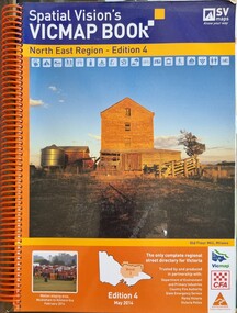 Wodonga & District Historical Society Inc
Book - Spatial Vision's VICMAP BOOK 2014 - North East Region
This edition of Spatial Vision's VicMap Book North East Region was published in May 2014 and provides detailed topographic maps for the region. It was used by emergency services and various agencies, including the Country Fire Authority (CFA). It covers areas including Wodonga, Albury, Wangaratta, and beyond, including national parks and recreation areas. Text on the cover states that the volume is "Trusted by and produced in partnership with: Department of Environment, Land, Water & Planning, Country Fire Authority, State Emergency Service, Parks Victoria, Victoria Police".A spiral bound volume of 409 pages including colour topographic maps and illustrations of North East Victoria. The cover features a colour photo of the old flour mill at Milawa, Victoria. It also features an index map inside the front cover, a legend, road index, and locality index.non-fictionThis edition of Spatial Vision's VicMap Book North East Region was published in May 2014 and provides detailed topographic maps for the region. It was used by emergency services and various agencies, including the Country Fire Authority (CFA). It covers areas including Wodonga, Albury, Wangaratta, and beyond, including national parks and recreation areas. Text on the cover states that the volume is "Trusted by and produced in partnership with: Department of Environment, Land, Water & Planning, Country Fire Authority, State Emergency Service, Parks Victoria, Victoria Police".emergency management north east victoria, cfa wodonga -
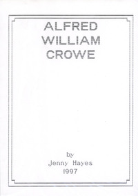 Narre Warren and District Family History Group
Book, Jenny Hayes, Alfred Willliam Crowe. Transcripts from his diary in the Ballarat Region
Story of Alfred William Crowe from England to Australianon-fictionStory of Alfred William Crowe from England to Australiaalfred william crowe, jessie miller -
 Marysville & District Historical Society
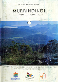
Booklet (Item) - Information booklet, Alexandra Newspapers, OFFICIAL VISITORS' GUIDE MURRINDINDI VICTORIA-AUSTRALIA, 03-2005
An information booklet on the Murrindindi region in Victoria. This information booklet was produced by Alexandra Newspapers in partnership with the Murrindindi Regional Tourism Association in March 2005.An information booklet on the Murrindindi region in Victoria.Produced and published by Alexandra Newspapers/ Pty Ltd in partnership with the Murrindindi Regional/ Tourism Association. murrindindi, victoria, australia, alexandra, eildon, kinglake, marysville, yea, yarra valley, high country, visit victoria, alexandra newspapers, murrindindi tourism association, rubicon valley horse riding, cathedral range state park, murrindindi scenic reserve, yarra ranges national park, cumberland memorial scenic reserve, the big culvert, cambarville, the big tree, steavenson falls, cora lynn falls, cumberland falls, lady talbot drive, phantom falls, keppel falls, the beeches, the cascades, wilhelmina falls, murrindindi cascades, lake mountain, cathedral lane vineyard, south cathedral farm, marysville holiday cottages, crystal journey, country touch, marysville ski centre, mountain lodge marysville, eco adventure tours, the mountain gallery, marysville country real estate, camellia log cabin, crossways historic country inn, marylands country house, ashlar cottage b&b, kerami guesthouse, melina cottages, willowbank at taggerty, mary lyn holiday resort, kooringa resort & conference centre, marysville caravan & holiday park, lyell guest cottages, eagle mountain retreat, keppels hotel motel, anastasia fairytale cottage, mystic mountain holiday cottages, esa camping & conference centre, buxton trout & salmon farm, woodlands rainforest bungalows, the old woolshed cafe, yarrolyn holiday park -
 Marysville & District Historical Society
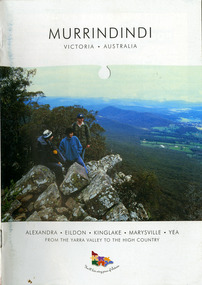
Booklet (Item) - Information booklet, Alexandra Newspapers, MURRINDINDI VICTORIA-AUSTRALIA, 02-2004
An information booklet on the Murrindindi region in Victoria. This information booklet was produced by Alexandra Newspapers in partnership with the Murrindindi Regional Tourism Association in February 2004.An information booklet on the Murrindindi region in Victoria.Produced and published by Alexandra Newspapers/ Pty Ltd in partnership with the Murrindindi Regional/ Tourism Association. murrindindi, victoria, australia, alexandra, eildon, kinglake, marysville, yea, yarra valley, high country, visit victoria, alexandra newspapers, murrindindi tourism association, rubicon valley horse riding, cathedral range state park, murrindindi scenic reserve, yarra ranges national park, cumberland memorial scenic reserve, the big culvert, cambarville, the big tree, steavenson falls, cora lynn falls, cumberland falls, lady talbot drive, phantom falls, keppel falls, the beeches, the cascades, wilhelmina falls, murrindindi cascades, lake mountain, cathedral lane vineyard, south cathedral farm, marysville holiday cottages, crystal journey, country touch, marysville ski centre, mountain lodge marysville, eco adventure tours, the mountain gallery, marysville country real estate, camellia log cabin, crossways historic country inn, marylands country house, ashlar cottage b&b, kerami guesthouse, melina cottages, willowbank at taggerty, mary lyn holiday resort, kooringa resort & conference centre, marysville caravan & holiday park, lyell guest cottages, eagle mountain retreat, keppels hotel motel, anastasia fairytale cottage, mystic mountain holiday cottages, esa camping & conference centre, buxton trout & salmon farm, woodlands rainforest bungalows, the old woolshed cafe, yarrolyn holiday park