Showing 124 items
matching rock formation
-
 Phillip Island and District Historical Society Inc.
Photograph, 1940's - 1950's
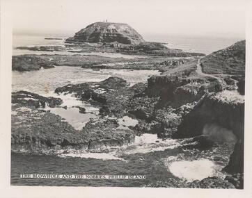
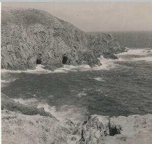
... to Phillip Island. blowhole the nobbies blowhole phillip island rock ...One of a collection of 9 photographs donated by the former Shire of Phillip Island. One of a series of photographs sold as a pack of postcards for tourists/visitors to Phillip Island.Black & White photograph - view of Blowhole and The Nobbies from the lookout at The Nobbies."The Blowhole and The Nobbies. Phillip Island"blowhole, the nobbies blowhole phillip island, rock formations, phillip island coastline, shire of phillip island -
 Phillip Island and District Historical Society Inc.
Photograph - Post Card, Early 20th Century
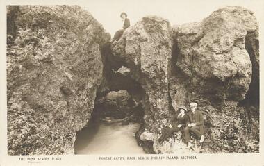
... island coastline rock formations phillip island t h hill ...One of a collection of 6 photograps/postcards donated by T. H. HillSepia postcard of Forrest Caves, Phillip Island. Lady on top and lady and man in the foreground. "The KRose Series, P671" "Forest Caves, Back Beach, Phillip Island, Victoria"forrest caves phillip island, phillip island coastline, rock formations phillip island, t h hill -
 Phillip Island and District Historical Society Inc.
Photograph - Post Card, Early 20th Century
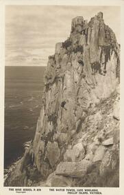
... coastline rock formations t h hill "The Rose Series, P. 679 ...One of a collection of 6 postcards donated by T. H. HillSepia Postcard of The Watch Tower, Cape Woolamai, Phillip Island"The Rose Series, P. 679" "The Watch Tower, Cape Woolamai, Phillip Island, Victoria"the watch tower, the watch tower cliffs, coastline cape woolamai, cape woolamai cliffs, phillip island coastline, rock formations, t h hill -
 Phillip Island and District Historical Society Inc.
Photograph - Post Card, Early 1900's
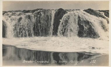
... phillip island rock formations phillip island bernard grayden ...Donated by Bernard GraydenPostcard of cascades falling over the rocks at The Nobbies. Foaming water in foreground.Breaker Cascades. The Nobby. Phillip Is. 232.the nobbies phillip island, rock formations, phillip island, bernard grayden -
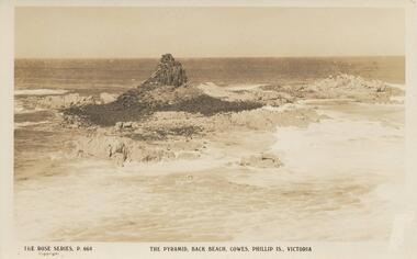 Phillip Island and District Historical Society Inc.
Photograph - Post Card, Early 1900's
... rocks phillip island phillip island rock formations The Rose ...Donated by Bernard GraydenSepia Postcard of Pyramid Rock surrounded by sea.The Rose Series. P. 664. The Pyramid, Back Beach, Cowes, Phillip Is., Victoria.pyramid rocks phillip island, phillip island, rock formations -
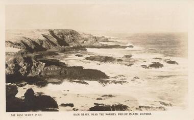 Phillip Island and District Historical Society Inc.
Photograph - Post Card, Early 1900's
... phillip island phillip island rock formations n g hunt "The Rose ...Donated by N. G. HuntSepia Postcard of sea washing up onto rocks at Back Beach near The Nobbies."The Rose Series, P. 667" "Back Beach. Near The Nobbies, Phillip Island, Victoria"back beach phillip island, phillip island, rock formations, n g hunt -
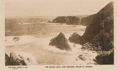 Phillip Island and District Historical Society Inc.
Photograph - Post Card, Early 1900's
... coastline cape woolamai phillip island rock formations n g hunt ...Donated by N. G. Hunt, Baxter, VictoriaSepia Postcaard of the sea crashing on to the rocky foreshore at Cape Woolamai."The Rose Series, P. 681" "The Rugged Coast, Cape Woolamai, Phillip Is., Victoria"coastline cape woolamai, phillip island, rock formations, n g hunt -
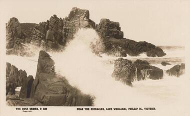 Phillip Island and District Historical Society Inc.
Photograph - Post Card, Early 1900's
... the pinnacles cape woolamai phillip island rock formations n g hunt ...Donated by N. G. Hunt, Baxter, VictoriaBlack & White Postcard of the sea breaking onto rocks near The Pinnacles at Cape Woolamai."The Rose Series, P. 682" "Near The Pinnacles, Cape Woolamai, Phillip Is., Victoria"the pinnacles, cape woolamai, phillip island, rock formations, n g hunt -
 Phillip Island and District Historical Society Inc.
Photograph
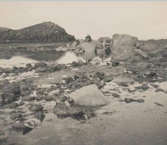
... rock black & white photograph coastline rock formations pyramid ...One of a collection of over 400 photographs in an album commenced in 1960 and presented to the Phillip Island & Westernport Historical Society by the Shire of Phillip IslandPhotograph of the basalt cliffs and shore platform near Pyramid Rocklocal history, photography, cliffs and shoreline pyramid rock, black & white photograph, coastline, rock formations, pyramid rock, dr a b edwards, john jenner, bryant west -
 Phillip Island and District Historical Society Inc.
Photograph
... & white photograph coastline rock formations cape woolamai John ...One of a collection of over 400 photographs in an album commenced in 1960 and presented to the Phillip Island & Westernport Historical Society by the Shire of Phillip IslandPhotograph of Caves on the waterline at Cape Woolamai. The caves can only be entered by boat.local history, photography, caves at cape woolamai, black & white photograph, coastline, rock formations, cape woolamai, john jenner, bryant west -
 Phillip Island and District Historical Society Inc.
Photograph
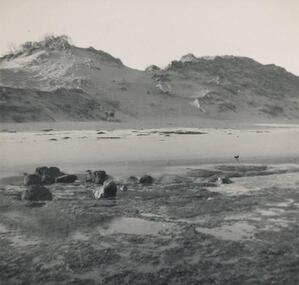
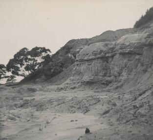
... & white photograph rock formations surf beach sand dunes Phillip ...One of a collection of over 400 photographs in an album commenced in 1960 and presented to the Phillip Island & Westernport Historical Society by the Shire of Phillip IslandPhotograph at Surf Beach showing shore platform beach sands and 15mt sand duneslocal history, photography, eastern end of surf beach, black & white photograph, rock formations, surf beach, sand dunes, phillip island coastline, john jenner, bryant west -
 Phillip Island and District Historical Society Inc.
Photograph, Bryant West
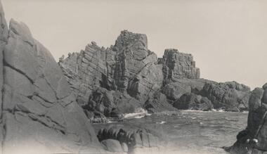
... formations cape woolamai phillip island granite rock formations john ...One of a collection of over 400 photographs in an album commenced in 1960 and presented to the Phillip Island & Westernport Historical Society by the Shire of Phillip IslandPhotograph of Granite Formations on Cape Woolamai.local history, photography, photographs, coastline, rock formations, cape woolamai, phillip island, granite rock formations, john jenner, bryant west -
 Phillip Island and District Historical Society Inc.
Photograph, Bryant West
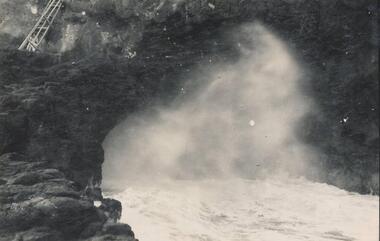
... phillip island rock formations the nobbies john jenner bryant west ...One of a collection of over 400 photographs in an album commenced in 1960 and presented to the Philip Island & Westernport Historical Society by the Shire of Phillip IslandPhotograph of Blowhole taken at sea levellocal history, photography, photographs, film, rocks, blowhole, phillip island, rock formations, the nobbies, john jenner, bryant west -
 Phillip Island and District Historical Society Inc.
Photograph, Dr G Baker
... Island local history photography rock formations black & white ...One of a collection of over 400 photographs in an album commenced in 1960 and presented to the Phillip Island & Westernport Historical Society by the Shire of Phillip IslandPhotograph of inter basaltic formations on basalt shore platform eastern end of Smith's Beachlocal history, photography, rock formations, black & white photograph, coastline, smith's beach, dr g baker, john jenner, bryant west -
 Phillip Island and District Historical Society Inc.
Photograph, Dr G Baker
... & white photograph coastline rock formations rhyll Dr G Baker John ...One of a collection of over 400 photographs in an album commenced in 1960 and presented to the Phillip Island & Westernport Historical Society by the Shire of Phillip IslandPhotograph of a Quarry in jurassie rock near Rhylllocal history, photography, jurassic rock quarry, black & white photograph, coastline, rock formations, rhyll, dr g baker, john jenner, bryant west -
 Phillip Island and District Historical Society Inc.
Photograph
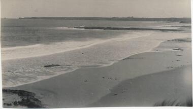
... & white photograph coastline geology rock formations John Jenner ...One of a collection of over 400 photographs in an album commenced in 1960 and presented to the Phillip Island & Westernport Historical Society by the Shire of Phillip IslandPhotograph of the basalt Jetty and geological feature near Surf Beachlocal history, photography, basalt jetty, surf beach, black & white photograph, coastline, geology, rock formations, john jenner, bryant west -
 Eltham District Historical Society Inc
Negative - Photograph, Warrandyte Bridge over River Yarra, c.1910
View of the 1875 timber trestle bridge over the Yarra River reproduced from a newsprint image. Also known as Anderson's Creek (Road) Bridge A contract was accepted for William Elliot to erect a bridge over the Yarra River at Warrandyte on Anderson's Creek Road and other improvements for £1,331.6.2 - Gazette No. 143. Tuesday, November 13th 1860 - http://gazette.slv.vic.gov.au/view.cgi?year=1860&class=general&page_num=2161&state=V&classNum=G143&id=). The bridge was washed away by floods in 1863. It was replaced with a taller timber trestle structure in October 1875, designed and built by C.S. Wingrove, Shire Clerk, Engineer and Surveyor for Eltham Shire Council. A replacement for this bridge was commenced in 1955 to cope with increasing traffic and this structure was widened in 2018 to meet further traffic demands. Argus (Melbourne, Vic. : 1848 - 1957), Thursday 23 September 1875, page 7 ________________________________________ THE WARRANDYTE BRIDGE. The ceremony of formally opening the newly erected bridge over the Yarra at Ander-son's Creek was performed on Monday last, in the presence of the members of the Eltham and Bulleen shire councils whose territories it joins, and a goodly number of the residents of the district. The task was delegated to Mr. Cameron, M.L.A., who, after a few introductory remarks declared the bridge to be opened, and christened it the " Warrandyte Bridge." The party then adjourned to Grant's Hotel, where a cold collation had been prepared. The chair was taken by the president of the Eltham shire (Mr. John Bell) and the vice chair by Mr. Kent, a member of the Bulleen council. Mr Robert Williamson proposed "Success to the bridge," coupling with it the name of Mr. Cameron, to whose exertions was in the main to be attributed the erection of that structure which was an ornament to the district and would prove of great service to both sides of the river. Mr. Cameron, in responding, alluded to the great difficulties, mainly of a pecuniary nature, that had been encountered in carrying out the project, and which had only been got over by their united efforts and by the liberal spirit in which the late Commissioner of Roads had dealt with the case. The healths of the contractor and the engineer were also drunk. The bridge is a trussed timber one, resting on yellow box piles sunk into the solid rock, each pier being weighted with 50 tons of stone. The abutments consist of dry stone walls, 6ft. thick at the base, and tapering to 3ft. on the top, the face of the work having a batter of 1 to 1. The length of the bridge is 308ft., there being four openings in the centre of 66ft. each, and two at the ends of 20ft. each. The width in the clear is 9½ft., and the height from the bed of the river about 33ft. The approaches comprise 1,100 cubic yards of earthwork, and the formation of 48 chains of sideling, the whole cost of the work, which was carried out under the direction of the engineer to the Eltham Shire Council, being £1,413.This photo forms part of a collection of photographs gathered by the Shire of Eltham for their centenary project book,"Pioneers and Painters: 100 years of the Shire of Eltham" by Alan Marshall (1971). The collection of over 500 images is held in partnership between Eltham District Historical Society and Yarra Plenty Regional Library (Eltham Library) and is now formally known as the 'The Shire of Eltham Pioneers Photograph Collection.' It is significant in being the first community sourced collection representing the places and people of the Shire's first one hundred years.Digital image 4 x 5 inch B&W Neg B&W Print 12.5 x 9 cmsepp, shire of eltham pioneers photograph collection, warrandyte, bridge -
 Flagstaff Hill Maritime Museum and Village
Slate pencil, Made on or before May 1891
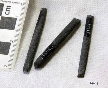
... a material of natural formation, for example sedimentary rock... a material of natural formation, for example sedimentary rock ...Slate pencils were made from a rod of soft slate material and used for writing on thin slate boards. The slate boards were approximately 9cm x 12cm used in schools for writing practice in place of pencil and paper, which were more expensive and less durable. They could be used then easily erased for re-use. In work places, slate boards were sometimes bound into slate books The three-masted iron barque Fiji had been built in Belfast, Ireland, in 1875 by Harland and Wolfe for a Liverpool based shipping company. The ship departed Hamburg on 22nd May 1891 bound for Melbourne, under the command of Captain William Vickers with a crew of 25. The ship’s manifest shows that she was loaded with a cargo of 260 cases of dynamite, pig iron, steel goods, spirits (whisky, schnapps, gin, brandy), sailcloth, tobacco, coiled fencing wire, concrete, 400 German pianos (Sweet Hapsburg), concertinas and other musical instruments, artists supplies including brushes, porcelain, furniture, china, and general cargo including candles. There were also toys in anticipation for Christmas, including wooden rocking horses, miniature ships, dolls with china limbs and rubber balls. On September 5th, one hundred days out from Hamburg in squally and boisterous south west winds the Cape Otway light was sighted on a bearing differing from Captain Vickers’ calculation of his position. At about 2:30am, Sunday 6th September 1891 land was reported 4-5 miles off the port bow. The captain tried to put the ship on the other tack, but she would not respond. He then tried to turn her the other way but just as the manoeuvre was being completed the Fiji struck rock only 300 yards (274 metres) from shore. The place is known as Wreck Bay, Moonlight Head. Blue lights were burned and rockets fired whilst an effort was made to lower boats but all capsized or swamped and smashed to pieces. Two of the younger crewmen volunteered to swim for the shore, taking a line. One, a Russian named Daniel Carkland, drowned after he was swept away when the line broke. The other, 17 year old able seaman Julius Gebauhr, a German, reached shore safely on his second attempt but without the line, which he had cut lose with his sheath-knife when it become tangled in kelp. He rested on the beach a while then climbed the steep cliffs in search of help. At about 10am on the Sunday morning a party of land selectors - including F. J. Stansmore, Leslie Dickson (or Dixon) and Mott - found Gebauhr. They were near Ryans Den, on their travels on horseback from Princetown towards Moonlight Head, and about 5km from the wreck. Gebauhr was lying in the scrub in a poor state, bleeding and dressed only in singlet, socks and a belt with his sheath-knife, ready for all emergencies. At first they were concerned about his wild and shaggy looking state and what seemed to be gibberish speech, taking him to be an escaped lunatic. They were reassured after he threw his knife away and realised that he was speaking half-English, half-German. They gave him food and brandy and some clothing and were then able to gain information about the wreck. Some of the men took him to Rivernook, a nearby guest house owned by John Evans, where he was cared for. Stansmore and Dickson rode off to try and summon help. Others went down to the site of the wreck. Messages for rescuing the rest of the crew were sent both to Port Campbell for the rocket rescue crew and to Warrnambool for the lifeboat. The S.S. Casino sailed from Portland towards the scene. After travelling the 25 miles to the scene, half of the Port Campbell rocket crew and equipment arrived and set up the rocket tripod on the beach below the cliffs. By this time the crew of the Fiji had been clinging to the jib-boom for almost 15 hours, calling frantically for help. Mr Tregear from the Rocket Crew fired the line. The light line broke and the rocket was carried away. A second line was successfully fired across the ship and made fast. The anxious sailors then attempted to come ashore along the line but, with as many as five at a time, the line sagged considerably and some were washed off. Others, nearly exhausted, had to then make their way through masses of seaweed and were often smothered by waves. Only 14 of the 24 who had remained on the ship made it to shore. Many onlookers on the beach took it in turns to go into the surf and drag half-drowned seamen to safety. These rescuers included Bill (William James) Robe, Edwin Vinge, Hugh Cameron, Fenelon Mott, Arthur Wilkinson and Peter Carmody. (Peter Carmody was also involved in the rescue of men from the Newfield.) Arthur Wilkinson, a 29 year old land selector, swam out to the aid of one of the ship’s crewmen, a carpenter named John Plunken. Plunken was attempting to swim from the Fiji to the shore. Two or three times both men almost reached the shore but were washed back to the wreck. A line was thrown to them and they were both hauled aboard. It was thought that Wilkinson struck his head on the anchor before s they were brought up. He remained unconscious. The carpenter survived this ordeal but Wilkinson later died and his body was washed up the next day. It was 26 year old Bill Robe who hauled out the last man, the captain, who had become tangled in the kelp. The wreck of the Fiji was smashed apart within 20 minutes of the captain being brought ashore, and it settled in about 6m of water. Of the 26 men on the Fiji, 11 in total lost their lives. The remains of 7 bodies were washed onto the beach and their coffins were made from timbers from the wrecked Fiji. They were buried on the cliff top above the wreck. The survivors were warmed by fires on the beach then taken to Rivernook and cared for over the next few days. Funds were raised by local communities soon after the wreck in aid of the sufferers of the Fiji disaster. Captain Vickers was severely reprimanded for his mishandling of the ship. His Masters Certificate was suspended for 12 months. At the time there was also a great deal of public criticism at the slow and disorganised rescue attempt to save those on board. The important canvas ‘breech buoy’ or ‘bucket chair’ and the heavy line from the Rocket Rescue was in the half of the rocket outfit that didn’t make it in time for the rescue: they had been delayed at the Gellibrand River ferry. Communications to Warrnambool were down so the call for help didn’t get through on time and the two or three boats that had been notified of the wreck failed to reach it in time. Much looting occurred of the cargo that washed up on the shore, with nearly every visitor leaving the beach with bulky pockets. One looter was caught with a small load of red and white rubber balls, which were duly confiscated and he was ‘detained’ for 14 days. Essence of peppermint mysteriously turned up in many settlers homes. Sailcloth was salvaged and used for horse rugs and tent flies. Soon after the wreck “Fiji tobacco” was being advertised around Victoria. A Customs officer, trying to prevent some of the looting, was assaulted by looters and thrown over a steep cliff. He managed to cling to a bush lower down until rescued. In 1894 some coiled fencing wire was salvaged from the wreck. Hundreds of coils are still strewn over the site of the wreck, encrusted and solidified. The hull is broken but the vessel’s iron ribs can be seen along with some of the cargo of concrete and pig iron. Captain Vickers presented Bill Robe with his silver-cased pocket watch, the only possession that he still had, as a token for having saved his life and the lives of some of the crew. (The pocket watch came with 2 winding keys, one to wind it and one to change the hands.) Years later Bill passed the watch to his brother-in-law Gib (Gilbert) Hulands as payment of a debt and it has been passed down the family to Gilbert Hulands’ grandson, John Hulands. Seaman Julius Gebauhr later gave his knife, in its hand crafted leather sheath, to F. J. Stansmore for caring for him when he came ashore. The knife handle had a personal inscription on it. A marble headstone on the 200m high cliffs overlooking Wreck Beach, west of Moonlight Head, paying tribute to the men who lost their lives when Fiji ran aground. The scene of the wreck is marked by the anchor from the Fiji, erected by Warrnambool skin divers in 1967. Amongst the artefacts salvaged from the Fiji are china miniature animals, limbs from small china dolls, rubber balls, a slate pencil, a glass bottle, sample of rope from the distress rocket and a candlestick holder. These items are now part of the Fiji collection at Flagstaff Hill Maritime Museum, along with Captain Vickers’ pocket watch and Julius Gebauhr’s sheath knife. Flagstaff Hill’s Fiji collection is of historical significance at a State level because of its association with the wreck Fiji, which is on the Victorian Heritage Register VHR S259. The Fiji is archaeologically significant as the wreck of a typical 19th century international sailing ship with cargo. It is educationally and recreationally significant as one of Victoria's most spectacular historic shipwreck dive sites with structural features and remains of the cargo evident. It also represents aspects of Victoria’s shipping history and its potential to interpret sub-theme 1.5 of Victoria’s Framework of Historical Themes (living with natural processes). The Fiji collection meets the following criteria for assessment: Criterion A: Importance to the course, or pattern, of Victoria’s cultural history. Criterion B: Possession of uncommon, rare or endangered aspects of Victoria’s cultural history Criterion C: Potential to yield information that will contribute to an understanding of Victoria’s cultural history. Remnants of a black slate pencil salvaged from the wreck of the Fiji. Pencil has no casing and is in three pieces. One piece is broken laterally and has a rounded end. The other two pieces have a longitudinal break and fit together. (The nature of the break indicates a material of natural formation, for example sedimentary rock such as slate.) flagstaff hill, warrnambool, shipwrecked coast, flagstaff hill maritime museum, maritime museum, shipwreck coast, flagstaff hill maritime village, great ocean road, slate pencil, pencil, slate board, writing, stationery -
 Bendigo Historical Society Inc.
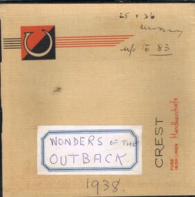
Newspaper - LYDIA CHANCELLOR COLLECTION: WONDERS OF THE OUTBACK
A handkerchief box containing newspaper cuttings from 'The Sun-News Pictorial' dated 1938, 'Wonders Of The Outback' on the beauty of and life in the outback. A series numbered 1 to 83. these clips contain photos and descriptions of Aboriginal/Indigenous People, Flora, Fauna, Lizards, Insects, land formations etc.Wonders of the outback 1938. 25 + 26 missing. Up to 83sciences, general, flora and fauna, lydia chancellor, collection, australian outback, outback, australian wildlife, wildlife, australian aborigines, aborigines, australian birds, birds, australian rock carvings, rock carvings, australian deserts, deserts, aboriginal, place, sciences, region, australia, plants, flora, fauna -
 National Vietnam Veterans Museum (NVVM)
Photograph
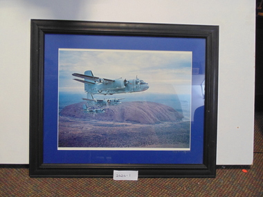
... in formation near Ayers Rock (now called Uluru). The numbers... A framed coloured photograph of three Navy trackers in formation ...A framed coloured photograph of three Navy trackers in formation near Ayers Rock (now called Uluru). The numbers on the Trackers are 852, 848, and 849photograph, navy trackers -
 Ballarat Heritage Services
Photograph - Colour, Tower Hill, 2016, 31/12/2016
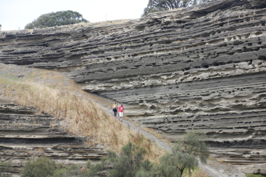
Tower Hill is a volcanic formation believed to have erupted about 32,000 years ago. Its formation is known as a "nested maar" and it is the largest example of its type in Victoria. During formation, molten lava pushed its way up through the Earth’s crust and encountered a layer of water-bearing rock. Violent explosions followed creating a shallow crater which later filled with water to form the lake. Further eruptions occurred in the centre of this crater, creating the islands and cone shaped hills. In 1892 Tower Hill became Victoria’s first National Park. In 1961, Tower Hill became a State Game Reserve under the then Fisheries and Wildlife Department and a major re-vegetation program began. (https://www.towerhill.org.au/index.php/about-reserve/history, accessed 23 December 2019)A number of photographs taken at Tower Hill, including the lakes, volcanic ash layer, and koala.tower hill, ash layer, volcano -
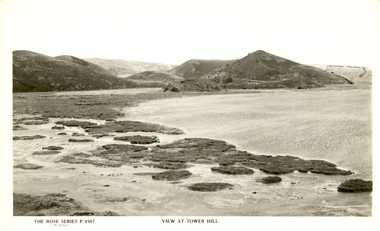
 Ballarat Heritage Services
Photograph - Image, Tower Hill, Victoria, c1918, c1918
Tower Hill is a volcanic formation believed to have erupted about 32,000 years ago. Its formation is known as a "nested maar" and it is the largest example of its type in Victoria. During formation, molten lava pushed its way up through the Earth’s crust and encountered a layer of water-bearing rock. Violent explosions followed creating a shallow crater which later filled with water to form the lake. Further eruptions occurred in the centre of this crater, creating the islands and cone shaped hills. In 1892 Tower Hill became Victoria’s first National Park. In 1961, Tower Hill became a State Game Reserve under the then Fisheries and Wildlife Department and a major re-vegetation program began. (https://www.towerhill.org.au/index.php/about-reserve/history, accessed 23 December 2019)Black and white image of Tower Hill, near Koroit, Victoria.tower hill, volcano, crater -
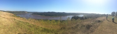 Ballarat Heritage Services
Photograph - Colour photograph, Tower Hill, 2016, 23/12/2015
Tower Hill is a volcanic formation believed to have erupted about 32,000 years ago. Its formation is known as a "nested maar" and it is the largest example of its type in Victoria. During formation, molten lava pushed its way up through the Earth’s crust and encountered a layer of water-bearing rock. Violent explosions followed creating a shallow crater which later filled with water to form the lake. Further eruptions occurred in the centre of this crater, creating the islands and cone shaped hills. In 1892 Tower Hill became Victoria’s first National Park. In 1961, Tower Hill became a State Game Reserve under the then Fisheries and Wildlife Department and a major re-vegetation program began. (https://www.towerhill.org.au/index.php/about-reserve/history, accessed 23 December 2019)Panaramic view of Tower Hill, Victoria.tower hill, volcano, crater -
 Ballarat Heritage Services
Photograph - Photograph - Black and White, Tower Hill, Victoria
Tower Hill is a volcanic formation believed to have erupted about 32,000 years ago. Its formation is known as a "nested maar" and it is the largest example of its type in Victoria. During formation, molten lava pushed its way up through the Earth’s crust and encountered a layer of water-bearing rock. Violent explosions followed creating a shallow crater which later filled with water to form the lake. Further eruptions occurred in the centre of this crater, creating the islands and cone shaped hills. In 1892 Tower Hill became Victoria’s first National Park. In 1961, Tower Hill became a State Game Reserve under the then Fisheries and Wildlife Department and a major re-vegetation program began. (https://www.towerhill.org.au/index.php/about-reserve/history, accessed 23 December 2019)Black and white photograph of Tower Hill devoid of trees.tower hill, crossley, volcano -
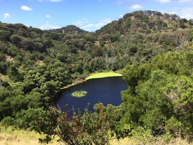 Ballarat Heritage Services
Photograph - Colour, Volcanic Crater at Tower Hill, 2017, 2017
Tower Hill is a volcanic formation believed to have erupted about 32,000 years ago. Its formation is known as a "nested maar" and it is the largest example of its type in Victoria. During formation, molten lava pushed its way up through the Earth’s crust and encountered a layer of water-bearing rock. Violent explosions followed creating a shallow crater which later filled with water to form the lake. Further eruptions occurred in the centre of this crater, creating the islands and cone shaped hills. In 1892 Tower Hill became Victoria’s first National Park. In 1961, Tower Hill became a State Game Reserve under the then Fisheries and Wildlife Department and a major re-vegetation program began. (https://www.towerhill.org.au/index.php/about-reserve/history, accessed 23 December 2019)Colour photographs of a lake in a volcanic crater at Tower Hill, Victoria. volcano, crater, lake, tower hill -
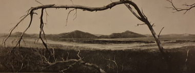
![View of the Hanging Rock, near Mount Macedon / [by] Nicholas Caire, circa 1876](/media/collectors/550653872162f11fb04854aa/items/577745a4d0cdd10a5c1059fc/item-media/57774673d0cdd10a5c10a562/item-fit-380x285.jpg) Kew Historical Society Inc
Kew Historical Society IncPhotograph, Anglo-Australasian Photographic Company, View of the Hanging Rock, near Mount Macedon, c. 1876
Nicholas Caire was born on Guernsey in the Channel Islands in 1837. He arrived in Adelaide with his parents in about 1860. In 1867, following photographic journeys in Gippsland, he opened a studio in Adelaide. From 1870 to 1876 he lived and worked in Talbot in Central Victoria. In 1876 he purchased T. F. Chuck's studios in the Royal Arcade Melbourne. In 1885, following the introduction of dry plate photography, he began a series of landscape series, which were commercially successful. As a photographer, he travelled extensively through Victoria, photographing places few of his contemporaries had previously seen. He died in 1918. Reference: Jack Cato, 'Caire, Nicholas John (1837–1918)', Australian Dictionary of Biography.An original, rare photograph from the series 'Views of Victoria: General Series' by the photographer, Nicholas Caire (1837-1918). The series of 60 photographs that comprise the series was issued c. 1876 and reinforced a neo-Romantic view of the Australian landscape to which a growing nationalist movement would respond. Nicholas Caire was active as a photographer in Australia from 1858 until his death in 1918. His vision of the Australian bush and pioneer life had a counterpart in the works of Henry Lawson and other nationalist poets, authors and painters.Albumen Silver Photograph on Boardprinted in ink on support l.c.: VIEW OF THE "HANGING ROCK," NEAR MOUNT MACEDON. / COPYRIGHT REGISTERED. printed in ink (vertically) on support reverse u.c.l.: J.W. FORBES, Agent, printed in ink (vertically) on support reverse c.l.: ANGLO-AUSTRALASIAN PHOTOGRAPHIC COMPANY, MELBOURNE. printed in ink (vertically) on support reverse c.: VIEWS OF VICTORIA. / (GENERAL SERIES.) / No. 6. / VIEW OF THE "HANGING ROCK," NEAR MOUNT MACEDON. / The Hanging Rock is situated about 5 miles in a north-easterly direction from the Railway Station at Woodend, / and is a very picturesque spot. Its formation is singularly peculiar, consisting of gigantic masses of basaltic rock / thrown up on end in a projecting or hanging position. Our illustration represents but a portion of the Rock, as it / is not possible to obtain a view of the whole of it in one picture. The height of these large boulders of rock vary / from 150 to 200 feet. printed in ink (vertically) on support reverse l.c.l.: 10 Temple Court, Collins Street West.nicholas caire (1837-1918), landscape photography -
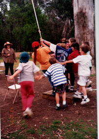 Sunbury Family History and Heritage Society Inc.
Photograph, Bulla Primary School, Hanging Rock, 17th October 1995
... rock climbing skills. The rock formations at Hanging Rock offer ...The older children from Bulla Primary School were attending a school camp at Hanging Rock where one of the activities involved learning basic rock climbing skills.The rock formations at Hanging Rock offer many opportunities for rock climbing. A non-digital coloured photograph of a group of children and hanging onto a rope that is suspended from a tree while one person is swinging from it. An adult is with the group supervising the activity.hanging rock, rock climbing, school camps, bulla primary school -
 Federation University Art Collection
Bookplate, Irena Sibley, ‘Ex Libris Edwin Jewell’
After a quiet period, interest in bookplates in Australia began to increase in the early 1970s, Entrepreneurial art and book collectors such as Edwin Jewell and others commissioned multiple Bookplate designs from a range of well known fine artists. At a 1997 meeting in Melbourne of the Ephemera Society of Australia Edwin Jewell and others announced the formation of the Australian Bookplate Society. The society was instrumental in promoting the art of the bookplate through establishment of the Australian Bookplate Design competition.A mermaid is depicted on a rockIS '07bookplate, printmaking, australian bookplate design awards -
Federation University Art Collection
Work on paper - Bookplate, ‘Ex Libris Edwin Jewell’
After a quiet period, interest in bookplates in Australia began to increase in the early 1970s, Entrepreneurial art and book collectors such as Edwin Jewell and others commissioned multiple Bookplate designs from a range of well known fine artists. At a 1997 meeting in Melbourne of the Ephemera Society of Australia Edwin Jewell and others announced the formation of the Australian Bookplate Society. The society was instrumental in promoting the art of the bookplate through establishment of the Australian Bookplate Design competition.A nude woman is depicted supporting herself on a rock below what appears to be flowing water.Pencil signature below printbookplate, printmaking, australian bookplate design award, keith wingrove memorial trust, life drawing -
Federation University Art Collection
Bookplate, ‘Ex Libris Edwin Jewell’
After a quiet period, interest in bookplates in Australia began to increase in the early 1970s, Entrepreneurial art and book collectors such as Edwin Jewell and others commissioned multiple Bookplate designs from a range of well known fine artists. At a 1997 meeting in Melbourne of the Ephemera Society of Australia Edwin Jewell and others announced the formation of the Australian Bookplate Society. The society was instrumental in promoting the art of the bookplate through establishment of the Australian Bookplate Design competition.A nude woman leans over a rock under what appears to be a waterfallPencil signaturebookplate, printmaking, life drawing, australian bookplate design award, keith wingrove memorial trust