Showing 9521 items
matching warrandyte
-
 Eltham District Historical Society Inc
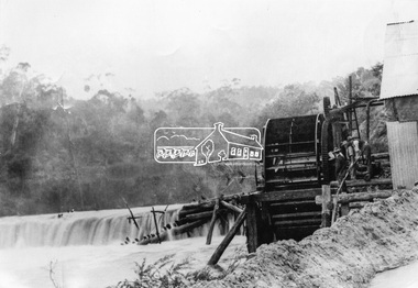
Photograph, Remains of the old Water Wheel and Battery, Warrandyte, 1934
A short distance upstream from the old wooden Warrandyte Bridge, the Yarra river was at one time dammed to give power to a large wooden waterwheel which drove a plant for crushing gold. Up until around 1908 the waters of the Yarra, pent up by a stone weir, forced their way past this old wheel turning it to crush the precious quartz. In 1925 the reamins of the State Battery were removed. The large water wheel (thanks to the forethought of a local resident, Mr. P. Mackie) was left in its position.This photo forms part of a collection of photographs gathered by the Shire of Eltham for their centenary project book,"Pioneers and Painters: 100 years of the Shire of Eltham" by Alan Marshall (1971). The collection of over 500 images is held in partnership between Eltham District Historical Society and Yarra Plenty Regional Library (Eltham Library) and is now formally known as the 'The Shire of Eltham Pioneers Photograph Collection.' It is significant in being the first community sourced collection representing the places and people of the Shire's first one hundred years.Digital image 4 x 5 inch B&W Negshire of eltham pioneers photograph collection, warrandyte, water wheel, caledonia battery, state battery, warrandyte battery -
 Ringwood and District Historical Society
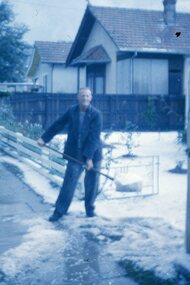
Photograph, Hail storm in Warrandyte Road, Ringwood late 1950s
Clarrie Burns, father of Neville, shovelling hail stones from his driveway at 13 Warrandyte Road, Ringwood in the late 1950s. Clarrie worked for Ringwood City Council as Superintendent of Works. In the image, number 11 Warrandyte Road was Sherman's house, number 9 the Haywards, then (hidden) the Salvation Army citadel. -
 Eltham District Historical Society Inc
Map, George W. Bell, A Visitor's Guide Map; ELTHAM, WARRANDYTE and Environs. Shire of Eltham Centenary Souvenir, 1971
Commissioned by George W. Bell, designed by Anthony Harvey. An old gold mining and wine growing district eighteen miles from Melbourne, now notable for its arts, crafts, good food and historic buildings. On the reverse side printed in 8 panels (3 half-folds) advertising for Montsalvat, Eltham; Kutta Mahal Gallery, Warrandyte; Country Art Store, Eltham; Eltham Crafts. Monstsalvat, Eltham; Tantoon native plants and culinary herbs, Eltham; The Claypot, Warrandyte; Research Trading, Research; Potters Cottage, Warrandyte; Graeme Law & Associates Pty Ltd, Kew.. In addition is provided The Shire of Eltham Cenenary 1871-1971 , Centenary Celebrations Programme of events from March through to August 1971.44..8 x 57.5 cm (Four copies) On the reverse side (of one copy only) is printed in 8 panels (3 half-folds) advertising and Centenary Program.eltham, warrandyte, map, advertising, montsalvat, kutta mahal gallery, country art store, the claypot, research trading, potters cottage, graeme law & associates pty ltd, eltham crafts, tantoon, shire of eltham centenary, program -
 Eltham District Historical Society Inc
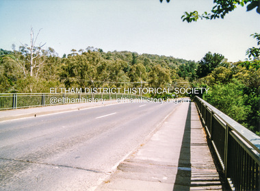
Photograph, Doug Orford, Bridge across Yarra River, Kangaroo Ground - Warrandyte Road, Warrandyte, 1991, 1991
From a collection of 35 photos taken by Doug Orford at 35 specific locations along the exact boundary of the then Shire of Eltham.Colour photographbridges, yarra river, warrandyte -
 Ringwood and District Historical Society
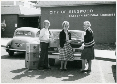
Photograph, Richard Steward, Ringwood Studios, Red Cross Ladies at Ringwood Library, Warrandyte Road, Ringwood - c.1970
Red Cross ladies loading books into cars at Ringwood Library, 28 Warrandyte Road, for distribution to remote readers. c.1970. -
 Eltham District Historical Society Inc
Photograph, The Leader, The "Black Swan" Mine and "The Old Dam", Warrandyte Gold Fields, 1897
Reproduced from "The Leader" 14th Aug. 1897, page 7 The "Black Swan" mine - on Captain Selby's property of 200 acres. Discovered by Captain Selby 8 years ago. He is working it himself. 'The shaft is down 70 feet and with deeper sinking the reef is found to increase in width. Nearly £2,000 has been obtained from this mine, the gold being of high quality, fetching £4-1-6 per oz.' Warrandyte photo "The Old Dam" - erected accross the river by Mr John Wallace, M.L.C., who attempted to turn the river and to work the river bed.This photo forms part of a collection of photographs gathered by the Shire of Eltham for their centenary project book,"Pioneers and Painters: 100 years of the Shire of Eltham" by Alan Marshall (1971). The collection of over 500 images is held in partnership between Eltham District Historical Society and Yarra Plenty Regional Library (Eltham Library) and is now formally known as the 'The Shire of Eltham Pioneers Photograph Collection.' It is significant in being the first community sourced collection representing the places and people of the Shire's first one hundred years.Digital imagesepp, shire of eltham pioneers photograph collection, warrandyte, gold mining, black swan mine, old dam -
 Eltham District Historical Society Inc
Document - Folder, Warrandyte Bushfire Relief, 1962
Following the January 1962 bushfires in Warrandyte, affected land holders and residents made application for financial assistance. These records are a small part of more than 1,300 applications made at the time. Contents include: Approximately 200 applications for assistance which include details of property, residence (holiday, farm holding, main residence), residents and property loss Approximately 500 Council responses for each application Miscellaneous correspondencePovides a clear description of property ownership, type, size, holdings and people at the timeapplication form, assessments, bushfire relief, eltham shire council, north warrandyte, scan - tbd, victorian bushfires - 1962, warrandyte -
 Ringwood and District Historical Society
Photograph, Warrandyte Historical Society Newsletters nos. 54-67
Digitised WHS newsletters from April 1987 (no. 54) to June 1989 (no. 67). Sent to Secretary of the Ringwood Historical Research Group, Jack Lindsay.Noteable articles:- Dr Ethel Osborne Frank and George Adams - Warrandyte orchardists History of Tills Drive Warrandyte Primary School Warrandyte Bridge The murder of Thomas Drew 1854 Timeline of some key Warrandyte dates Merv Naughton Houghton Road Hussey's Lane History of the Whitehouse Warrandyte Fire Brigade James Anderson The Warrandyte Pound Sloan butcher shop Roley Bus Service Stiggants -
 Ringwood and District Historical Society
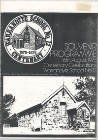
Booklet - Souvenir Programme, Warrandyte School No.12 Centenary 1875-1975
11-page centenary celebrations programme for Anderson's Creek/Warrandyte School no.12. Includes history of the school by Ted Rotherham, and list of head teachers. -
 Ringwood and District Historical Society
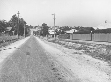
Photograph, Warrandyte Road (unmade Road). Ringwood. (undated, probably late 1960's/early 1970's)
Written on catalogue card, "Warrandyte Road". -
 Darebin Art Collection
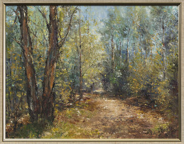
Painting, Patrick Burke, Landscape - through the trees, Warrandyte, 1981
warrandyte -
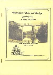 Ringwood and District Historical Society
Book, Bruce Bence, Warrandyte - A Brief History - by Bruce Bence 1991, 1991
Typewritten pages summarising history of Warrandyte from early European settlement around 1837. Yellow cover featuring a photograph of "The Wooden Bridge 1875-1955". -
 Ringwood and District Historical Society
Report, The Early History of Warrandyte, by W.W.L. Radden 11-Nov-1965, Nov-65
11 foolscap pages - The Early History of Warrandyte, prepared by W.W.L. Radden 11-Nov-1965, includes extensive references. +Additional Keywords: Radden, W.W.L. -
Warrandyte Diary
Newspaper - Periodicals, Monthly, Cliff Green, Warrandyte Diary, 1/12/1970
News and features relevant to the community of WarrandyteCommunity Newspaper printed on newsprint in two tone (black and red)non-fictionNews and features relevant to the community of Warrandyte -
Warrandyte Diary
Newspaper - Periodicals, Monthly, Cliff Green, Warrandyte Diary, 1/02/1971
News and features relevant to the community of WarrandyteCommunity Newspaper printed on newsprint in black and whitenon-fictionNews and features relevant to the community of Warrandyte -
Warrandyte Diary
Newspaper - Periodicals, Monthly, Cliff Green, Warrandyte Diary, 1/03/1971
News and features relevant to the community of WarrandyteCommunity Newspaper printed on newsprint in black and whitenon-fictionNews and features relevant to the community of Warrandyte -
Warrandyte Diary
Newspaper - Periodicals, Monthly, Cliff Green, Warrandyte Diary, 1/04/1971
News and features relevant to the community of WarrandyteCommunity Newspaper printed on newsprint in black and whitenon-fictionNews and features relevant to the community of Warrandyte -
Warrandyte Diary
Newspaper - Periodicals, Monthly, Cliff Green, Warrandyte Diary, 1/05/1971
News and features relevant to the community of WarrandyteCommunity Newspaper printed on newsprint in black and whitenon-fictionNews and features relevant to the community of Warrandyte -
Warrandyte Diary
Newspaper - Periodicals, Monthly, Cliff Green, Warrandyte Diary, 1/06/1971
News and features relevant to the community of WarrandyteCommunity Newspaper printed on newsprint in black and whitenon-fictionNews and features relevant to the community of Warrandyte -
Warrandyte Diary
Newspaper - Periodicals, Monthly, Cliff Green, Warrandyte Diary, 1/07/1971
News and features relevant to the community of WarrandyteCommunity Newspaper printed on newsprint in black and whitenon-fictionNews and features relevant to the community of Warrandyte -
Warrandyte Diary
Newspaper - Periodicals, Monthly, Cliff Green, Warrandyte Diary, 1/08/1971
News and features relevant to the community of WarrandyteCommunity Newspaper printed on newsprint in black and whitenon-fictionNews and features relevant to the community of Warrandyte -
Warrandyte Diary
Newspaper - Periodicals, Monthly, Cliff Green, Warrandyte Diary, 1/09/1971
News and features relevant to the community of WarrandyteCommunity Newspaper printed on newsprint in black and whitenon-fictionNews and features relevant to the community of Warrandyte -
Warrandyte Diary
Newspaper - Periodicals, Monthly, Cliff Green, Warrandyte Diary, 1/10/1971
News and features relevant to the community of WarrandyteCommunity Newspaper printed on newsprint in black and whitenon-fictionNews and features relevant to the community of Warrandyte -
Warrandyte Diary
Newspaper - Periodicals, Monthly, Cliff Green, Warrandyte Diary, 1/11/1971
News and features relevant to the community of WarrandyteCommunity Newspaper printed on newsprint in black and whitenon-fictionNews and features relevant to the community of Warrandyte -
Warrandyte Diary
Newspaper - Periodicals, Monthly, Cliff Green, Warrandyte Diary, 1/12/1971
News and features relevant to the community of WarrandyteCommunity Newspaper printed on newsprint in two tone (black and red)non-fictionNews and features relevant to the community of Warrandyte -
Warrandyte Diary
Newspaper - Periodicals, Monthly, Cliff Green, Warrandyte Diary, 1/02/1972
News and features relevant to the community of WarrandyteCommunity Newspaper printed on newsprint in black and whitenon-fictionNews and features relevant to the community of Warrandyte -
Warrandyte Diary
Newspaper - Periodicals, Monthly, Cliff Green, Warrandyte Diary, 1/03/1972
News and features relevant to the community of WarrandyteCommunity Newspaper printed on newsprint in black and whitenon-fictionNews and features relevant to the community of Warrandyte -
Warrandyte Diary
Newspaper - Periodicals, Monthly, Cliff Green & Peter Lovett, Warrandyte Diary, 1/04/1972
News and features relevant to the community of WarrandyteCommunity Newspaper printed on newsprint in two tone (black and red)non-fictionNews and features relevant to the community of Warrandyte -
Warrandyte Diary
Newspaper - Periodicals, Monthly, Cliff Green & Peter Lovett, Warrandyte Diary, 1/05/1972
News and features relevant to the community of WarrandyteCommunity Newspaper printed on newsprint in two tone (black and red)non-fictionNews and features relevant to the community of Warrandyte -
Warrandyte Diary
Newspaper - Periodicals, Monthly, Cliff Green, Warrandyte Diary, 1/06/1972
News and features relevant to the community of WarrandyteCommunity Newspaper printed on newsprint in two tone (black and red)non-fictionNews and features relevant to the community of Warrandyte