Showing 733 items
matching aerial photos
-
 Whitehorse Historical Society Inc.
Map, Husband Road, Forest Hill, 1972
... Enlarged aerial photo of area between Canterbury.... Melbourne, 1972 Enlarged aerial photo of area between Canterbury ...Enlarged aerial photo of area between Canterbury and Husband Roads Forest Hill. Melbourne, 1972Enlarged aerial photo of area between Canterbury and Husband Roads Forest Hill. Melbourne, 1972Enlarged aerial photo of area between Canterbury and Husband Roads Forest Hill. Melbourne, 1972canterbury road, forest hill, husband road, forest hill, hylton crescent, forest hill, sapphire street, forest hill, opal street, forest hill, amber street, forest hill, willurah street, forest hill, nunawading swimming pool, aerial photographs, nunawading memorial swimming pool, nunawading pool, aqualink nunawading -
Port Melbourne Historical & Preservation Society
Photograph - Double-sided aerial photograph, Hobson's Bay and the Yarra River/Port Phillip and Western Port Bay, Surveyor General and Director of Mapping, Apr 1990
... Aerial photos of Port Phillip and Western Port (double... trust - port of melbourne authority Aerial photos of Port ...Landsat imagery - an extract from the atlas of VictoriaAerial photos of Port Phillip and Western Port (double sided aerial photographs), framed and with timber display stand. 1995 side A: Hobson's Bay and Yarra River - aerial photo mosaic; side B. Port Phillip and Western Port Bays - satellite photomelbourne harbor trust - port of melbourne authority -
Glenelg Shire Council Cultural Collection
Photograph - Photograph - aerial view of Portland, n.d
... Black and white aerial photo of Portland Harbour, showing... Harbour Back: harb003 - pencil Black and white aerial photo ...Port of Portland AuthorityBack: harb003 - pencilport of portland archives, aerial photography, portland harbour -
Glenelg Shire Council Cultural Collection
Photograph - Photograph - oil rig, Portland Harbour, n.d
... Black and white aerial photo of Portland Harbour showing... Harbour Back: harb018 - pencil Black and white aerial photo ...Port of Portland Authority ArchivesBack: harb018 - pencilport of portland archives, oil rig, portland harbour -
Glenelg Shire Council Cultural Collection
Photograph - Photograph - aerial view of Portland harbour, n.d
... Black and white aerial photo of Portland Harbour, showing... - blue biro Black and white aerial photo of Portland Harbour ...Port of Portland AuthorityBack: P.12,(iii) black biro 16/17 - black biro 15/1.2 - blue biroport of portland archives, aerial photography, portland harbour -
Glenelg Shire Council Cultural Collection
Photograph - Photograph - Main Breakwater construction, Portland, n.d
... Black and white aerial photo of harbour, looking from main... - '14 Feb 1958' Black and white aerial photo of harbour, looking ...Port of Portland Authority ArchivesFront: Purplestamp-'14 Feb 1958 Back: Purple stamp - '14 Feb 1958'port of portland archives, aerial photography, portland harbour -
Port Melbourne Historical & Preservation Society
Photograph - Aerial view, Fishermen's Bend, 1947
... Aerial photo of Fishermen's Bend with Footscray... fishermans bend footscray Aerial photo of Fishermen's Bend ...Aerial photo of Fishermen's Bend with Footscray in foreground, Maribyrnong River and varous airfields upper left. c1947fishermans bend, footscray -
Whitehorse Historical Society Inc.
Map, Canterbury Road, Vermont, c1970
... Enlarged aerial photo of intersection of Canterbury... Photographs Enlarged aerial photo of intersection of Canterbury ...Enlarged aerial photo of intersection of Canterbury and Boronia Roads. State Aerial Survey, Melbourne 1970 project.Enlarged aerial photo of intersection of Canterbury and Boronia Roads. State Aerial Survey, Melbourne 1970 project.Enlarged aerial photo of intersection of Canterbury and Boronia Roads. State Aerial Survey, Melbourne 1970 project.canterbury road, vermont, boronia road, vermont, mitcham road, vermont, frances avenue, vermont, nurlendi road, vermont, webb court, vermont, vermont primary school, no. 1022, aerial photographs -
 Port Melbourne Historical & Preservation Society
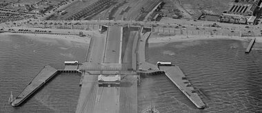
Photograph - Station Pier and surrounds c1940
... Aerial photo approx 1940 showing Station Pier, Centenary... Centenary Bridge Transport - Railways Swallow Street Aerial photo ...It appears that there was some sort of event as there are many pedestrians and many vehicles on Centenary Bridge but very few on the pier. Circa 1940.Aerial photo approx 1940 showing Station Pier, Centenary Bridge, railyards and vehicles on Swallow St. piers and wharves - station pier, centenary bridge, transport - railways, swallow street -
 Charlton Golden Grains Museum Inc
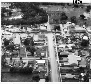
Photograph, Aerial photo of Armstrong St, Charlton, c.1974
... Aerial photo of Armstrong St, Charlton...Aerial photo looking down Armstrong St. Camp street...Black & white aerial photo looking down a broad street...Aerial photo looking down Armstrong St. Camp street ...Aerial photo looking down Armstrong St. Camp street on the left, Shire Hall on the right. High St runs across the photo. The Avoca River is visible in the top LH side. The swimming pool and bowling green is above the rive. On High St (from L-R) Dr Surgery, H Bath Chemist, Grocery, Roy Dobson, Hairdresser, Stowe's, Westpac Bank (two storey white building), Dillon's Building, Globe Hotel, Charlton Club, butcher shop, Arundell's shoe shop, Watson's Stock & Station Agency, Bullock's grocery, Williams St (Curtin Ave), Bannon's Butchers, East Charlton Hotel, MB Luth & Co, Lou's cafe. The old sale yards are at the end of Williams Street. Camp St lower side (from L-R) Court House, Police residence, Police Station, Telecom on corner. The photo is thought to be taken from Ossie Sanderson's airplane in 1974.Black & white aerial photo looking down a broad street that ends in a t-intersection. There is a street that comes off to the left about 1/3 of the way up the photo. There is a large building directly opposite this street. In the upper right there is a two storey building with arches on its verandah. In the upper LH side there is a swimming pool and bowling greens.armstrong st charlton, charlton, business, industry, westpac bank, globe hotel, east charlton hotel, dillon building -
 Greensborough Historical Society
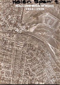
Booklet, Macleod High School 1954-1979, 1979_
... aerial photo of Macleod area...." 20 page booklet. B&W photos. Cover has black and white aerial ...Published to celebrate the silver jubilee of Macleod High School 1954-79, this booklet lists student leaders over 25 years. Photos are included from the 1950s.Documents changes over 25 years at Macleod High School.20 page booklet. B&W photos. Cover has black and white aerial photo of Macleod area.On cover "Helen Spence"macleod high school silver jubilee, macleod high school -
Glenelg Shire Council Cultural Collection
Photograph - Photograph - Cape Grant Quarry, n.d
... Black and white photo aerial photo, looking towards Cape... %' - green pencil, centre Black and white photo aerial photo, looking ...Port of Portland Authority ArchivesBack: 1 cm border ruled around photo in pencil. 'Reduce to 28 ems wide' in pencil, top border. '(15); pencil, bottom border. '58 %' - green pencil, centreport of portland archives, cape grant quarry -
Glenelg Shire Council Cultural Collection
Photograph - Photograph - Portland Harbour, n.d
... Black & white aerial photo of Portland Harbour, looking... biro Black & white aerial photo of Portland Harbour, looking ...Port of Portland Authority ArchivesBack: 2966 Blue Biro - 61/8 x 4/5 red pencil overwritten 3/4 in blue biroport of portland archives, portland harbour -
Glenelg Shire Council Cultural Collection
Photograph - Photograph - aerial view of Portland Harbour, 1958
... Black & white aerial photo of Portland harbour, foreshore... - blue biro Black & white aerial photo of Portland harbour ...Port of Portland Authority ArchivesBack: Purple stamp - 14 Jan 1958 Harbour from air - blue biroport of portland archives, aerial photography, portland harbour -
Glenelg Shire Council Cultural Collection
Photograph - Photograph - aerial view of Portland Harbour, 1958
... Black & white aerial photo of Portland harbour, foreshore... L 49 pencil Black & white aerial photo of Portland harbour ...Port of Portland Authority ArchivesBack: Purple Stamp - 14 Jun 1958 Harb-009 L 49 pencilport of portland archives, 1950s, 1958, aerial photography, portland harbour -
Glenelg Shire Council Cultural Collection
Photograph - Photograph - Early Shipping: Ocean/Railway Pier, n.d
... Black and white aerial photo. Showing cargo vessel berthed... Berthed Ocean Pier K S Anderson Black and white aerial photo ...Port of Portland Authority Archivesport of portland archives, portland harbour, ship berthed, ocean pier, k s anderson -
Glenelg Shire Council Cultural Collection
Photograph - Photograph - Quarry, Cape Grant, n.d
... Black and white aerial photo of Cape Grant quarry. Showing... Authority Archives Port of Portland Archives Black and white aerial ...Port of Portland Authority Archivesport of portland archives -
Port Melbourne Historical & Preservation Society
Postcard - Aerial view of piers at Port Melbourne, Aerial photo of Port Melbourne, c. 1922
... Aerial photo of Port Melbourne...Sepia picture postcard, unused, aerial photo showing ships... postcard, unused, aerial photo showing ships at Port Melbourne ...Sepia picture postcard, unused, aerial photo showing ships at Port Melbourne: Princes, Station and Town Pierstransport - shipping, piers and wharves - station pier, piers and wharves - princes pier, piers and wharves - town pier -
 Whitehorse Historical Society Inc.
Photograph, Burwood Technical School
... Strip of four coloured aerial photo of the Burwood... burwood technical school Strip of four coloured aerial photo ...Burwood Technical School was located on the south west corner of Middleborough and Elgar RoadsStrip of four coloured aerial photo of the Burwood Technical School Buildings taken sometime between 1986 and 1992.schools, burwood technical school -
 Whitehorse Historical Society Inc.
Photograph - Aerial Photograph, Tally Ho Industrial Park East Burwod, C.1995
... Aerial Photo of Tally Ho Industrial Park. East Burwood... east burwood reserve bill sewart athletic track Aerial Photo ...Aerial Photo of Tally Ho Industrial Park. East Burwood Reserve and the Bill Sewart Athletic Track is in centre.tally ho industrial park, lend lease development pty ltd, east burwood reserve, bill sewart athletic track -
Glenelg Shire Council Cultural Collection
Photograph - Photograph - Main Breakwater construction, Portland, n.d
... Black and white aerial photo of land reclamation and wharf...- pencil Back: 14/1/58 - Pencil Black and white aerial photo ...Port of Portland Authority ArchivesFront: 14/1/58- pencil Back: 14/1/58 - Pencilport of portland archives, main breakwater construction, harbour development, aerial photography -
Glenelg Shire Council Cultural Collection
Photograph - Photograph - Main Breakwater Construction, n.d
... Aerial Photo...Black and white aerial photo taken flying over Fawthrop... Fawthrop Lagoon Aerial Photo main breakwater construction Black ...Port Of Portland Authority Archivesport of portland archives, portland harbour, fawthrop lagoon, aerial photo, main breakwater construction -
Glenelg Shire Council Cultural Collection
Photograph - Photograph - Main Breakwater Construction, n.d
... Black & white aerial photo showing reclamation work on left... breakwater construction Battery Point Black & white aerial photo ...Port of Portland Authority Archivesport of portland archives, reclamation land, breakwater construction, battery point -
Port Melbourne Historical & Preservation Society
Photograph - Aerial view of River Yarra and Victoria Dock, 1920s
... Copy of aerial photo of River Yarra and Victoria Dock... transport - shipping Copy of aerial photo of River Yarra ...Copy of aerial photo of River Yarra and Victoria Dock, 1920s; pasted onto A4 sheet with computer graphics bordertransport - shipping -
Tatura Irrigation & Wartime Camps Museum
Aerial Photograph, 1959
... Enlarged aerial photo of Tatura township taken by J... Photographer Tel. Kyabram 629 Enlarged aerial photo of Tatura township ...Enlarged aerial photo of Tatura township taken by J. Underwood (Kyabram) in January 1959. Photo framed with glass front.Tatura Jan 1959. Arthur J. Underwood Photographer Tel. Kyabram 629tatura, aerial photography, photography, photograph, slides, film -
Whitehorse Historical Society Inc.
Map, Mitcham Road, c1970
... Enlarged aerial photo, c1970, of the intersection... School No. 2904 Aerial photographs Enlarged aerial photo ...Enlarged aerial photo of the intersection of Mitcham and East Doncaster Roads, Mitcham. Scale 1 inch : 40 feet.Enlarged aerial photo, c1970, of the intersection of Mitcham and East Doncaster Roads, Mitcham. Scale 1 inch : 40 feet.Enlarged aerial photo of the intersection of Mitcham and East Doncaster Roads, Mitcham. Scale 1 inch : 40 feet.mitcham road, mitcham, quarry road, mitcham, doncaster east road, mitcham, wooddale grove, mitcham, mitcham primary school, no. 2904, aerial photographs -
Whitehorse Historical Society Inc.
Map, Aerial photograph, c1950
... Aerial photo of Vermont South and Burwood East... and environs. Aerial photo of Vermont South and Burwood East ...Arial photo of Vermont South and Burwood East, Middleborough Road, Burwood Highway, Springvale Road, Highbury Road and environs.Aerial photo of Vermont South and Burwood East, Middleborough Road, Burwood Highway, Springvale Road, Highbury Road and environs.Arial photo of Vermont South and Burwood East, Middleborough Road, Burwood Highway, Springvale Road, Highbury Road and environs.vermont south, burwood east, aerial photographs -
Tatura Irrigation & Wartime Camps Museum
Photograph, 1940
... Camp 2 aerial photo... Camp 2 aerial photo... Tatura the-murray Camp 2 aerial photo Camp 2 aerial photo Italian ...Camp 2 aerial photoBlack and white photograph of Camp 2 (aerial) channel left hand side.camp 2 aerial photo, italian pow camp -
Stawell Historical Society Inc
Photograph, Stawell Aerial View 1933
... Aerial Photo of Stawell 1933... grampians Aerial Photo of Stawell 1933 stawell Stawell Aerial View ...Aerial Photo of Stawell 1933stawell -
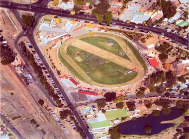 Stawell Historical Society Inc
Photograph, Central Park -- Aerial Photo 2007 -- Coloured
... Central Park -- Aerial Photo 2007 -- Coloured...Central Park (Aerial Photo) 2007... grampians Central Park (Aerial Photo) 2007 stawell sport Central ...Central Park (Aerial Photo) 2007stawell sport