Showing 120 items matching "alluvial gold"
-
 Bendigo Historical Society Inc.
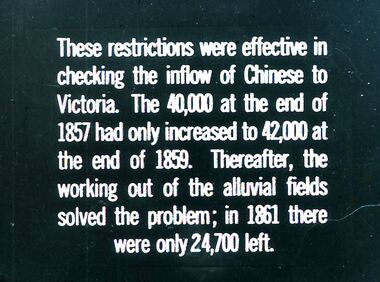
Slide - DIGGERS & MINING.GOLD, c1857
Diggers & Mining. Gold. These restrictions were effective in checking the inflow of Chinese to Victoria. The 40,000 at the end of 1857 had only increased to 42,000 at the end of 1859. Thereafter, the working out of the alluvial fields solved the problem; in 1861 there were only 24,000 left. Markings: 18 994.GOL. Used as a teaching aid.hanimounteducation, tertiary, goldfields -
 Bendigo Historical Society Inc.
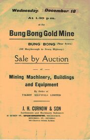
Document - IAN DYETT COLLECTION: AUCTION CATALOGUE - BUNG BONG GOLD MINE
... - Auction Catalogue - Bung Bong Gold Mine Talbot Alluvials Limited J ...Two white auction catalogues for a sale at the Bung Bong Gold Mine at Bung Bong (Near Avoca) on 18 December (no year stated) by order of Talbot Alluvials Limited. For sale was mining machinery, buildings, tools and equipment. Auctioneer was J. H. Curnow & Son.business, auctioneers, j h curnow & son pty ltd, ian dyett collection - auction catalogue - bung bong gold mine, talbot alluvials limited, j h curnow & son, the cambridge press -
 Bendigo Historical Society Inc.
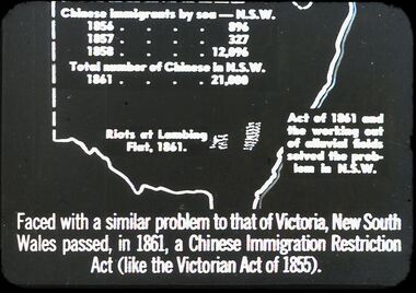
Slide - DIGGERS & MINING. THE CHINESE ON THE GOLD FIELDS, c1850s
Diggers & Mining. The Chinese on the Gold Fields. Slide: Map of New South Wales. Chinese immigration by sea - N.S.W. 1856 - 896, 1857 - 327, 1858 - 12,096. Total number of Chinese in N.S.W. 1861 - 21,000. Riots of Lambing Flat, 1861. Act of 1861 the working out of alluvial fields solved the problem in N.S.W. Faced with a similar problem to that of Victoria, New South Wales passed, in 1861, a Chinese Immigration Restriction Act (like the Victorian Act of 1855). Markings: 10 994:LIF I. Used as a teaching aid.hanimounteducation, tertiary, goldfields -
 Bendigo Historical Society Inc.
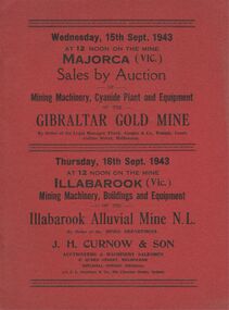
Document - IAN DYETT COLLECTION: AUCTION CATALOGUE - GIBRALTAR GOLD MINE
Two red covered catalogues for an auction of Mining Machinery, Cyanide Plant and Equipment held on the 15th September 1943 at the Gibraltar Gold Mine at Majorca, Vic. Sale by Order of Frank Cooper & Co. Also on 16th September 1943 a sale of Mining Machinery, Buildings and Equipment of the Illabarook Alluvial Mine N. L. By Order of the Mines Department. Catalogue gives the locality of the two mines. Sale conducted by permission of the Director of Machine Tools and Gauges under the Regulation 59 of the National Security (General) Regulations. J. H. Curnow & Son were the auctioneers.business, auctioneers, j h curnow & son pty ltd, ian dyett collection - auction catalogue - gibraltar gold mine, frank cooper & co, mines department, j h curnow & son, j l jamieson, regulation 59 of the national security (general) regulation, illabarook alluvial mine n l, the cambridge press -
 Bendigo Historical Society Inc.
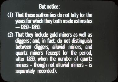
Slide - DIGGERS & MINING: DIGGERS & MINING
Diggers & Mining: Diggers & Mining. Slide reads; But notice: (1) That these authorities do not rally for the years for which they both made estimates - 1859 - 1860. (2) That they include gold miners as well as diggers; and, in fact, do not distinguish between diggers, alluvial miners, and quartz miners (except for the periods after 1859, when the number of quartz miners - though not alluvial miners - is separately recorded). Markings: 50/ 994:LIF 1. Used as a teaching aid.hanimounteducation, tertiary, mining -
 Bendigo Historical Society Inc.
Document - MCCOLL, RANKIN AND STANISTREET COLLECTION: SUNDRY REPORTS, 1930's
Manilla Folder containing reports from various mines in Bendigo and surrounding areas. 1. 4 page typewritten report on the Balaclava Hill Mine at Rushworth and some newspaper clippings about the mine with a plan of the underground workings; 2. Page from the Árgus' dated 2nd August 1900 featuring an article on the survey of the Garden line of Reefs; 3. 5 page report with maps on the Tooleen Gold Field; 4. Single page report about an unnamed mining area claimed to be on the southern end of the Deborah line of reef. (this could be the 'Three Jays' mine in Sedgwick. P. Wilkin); 5. Hand written report on the Coronation Mine, 2 miles east of Walhalla.; 6. Hand written report dated 1935, of the Queen Mary mine, St. Arnaud.; 7. 1932 report on the North Neangar lease.; 8 4 page report on the Kings Prize Gold Mining Syndicate.; 9. Description of the plant of the Marong Alluvial Company? Also a guide for marking out leases.; 10. Crushing details (1 page) from the 'Enterprise' Mine South of and adjacent to Perseverence.; 11. 1 page crushing details from Rowe Brothers, Mosquito Mine, Fryerstown.; 12 hand written report mentions Arthur Hatfield, Scarsdale.; 13. Map with lines of reef showing the position of the New Moon Consolidated and the New Moon United shafts.; 14, Large scale map from Harrison/Victoria street to Havilah Road showing the positions of the Carlisle, North Garden and Unity Shafts.gold mining, miners' safety cage, sundry reports, mining. bendigo, rushworth, balaclava hill, garden line of reef, toolleen, coronation mine, walhalla, queen mary mine, st. arnaud. north neangar, kings prize gold mining syndicate, marong, enterprise mine, perseverence, rowe brothers, mosquito mine, fryerstown, arthur hatfield, scarsdale, new moon consolidate, new moon united, carlisle, north garden, unity. -
 Bendigo Historical Society Inc.
Booklet - Victoria Hill
Victoria Hill, accessed from Marong Road, was one of the richest areas on the Bendigo goldfields and was the beginning of reef mining as opposed to alluvial mining. Between 1853 and 1861 there were 16 claims registered on Victoria Hill. Between 1908 and 1910 it was the site of the world's deepest shaft (1365-1406 meters)Today it provides interpretive walks that include sites such as an open-cut mine (1850's), poppet head, quartz crushing battery (1930's) and the foundations of George Lancell's 180 mine. It is registered as a site of historical significance.Clear plastic cover spiral bound booklet of 25 pages. 'Victoria Hill'. A historical background of Victoria Hill and the surrounding area. A colour photo of a poppet head on front. Original story written by Albert Richardson in 1971. This is a revised edition by Philip Wilkin in 2012. Illustrated with colour and B&W photos. Pages 13 to 25 have been inadvertently inserted upside down. A single page A4 leaflet 'Victoria Hill Self Guided Tour' has been put inside after page 1Handwritten in ink on front page 'Donated to Specimen Cottage'victoria hill, gold mine -
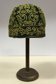 Kew Historical Society Inc
Headwear - Green Cotton & Yellow Silk Ribbon Smoker's or Lounge Cap, 1860s
The context in which the hat was made and worn assists in establishing its potential historic significance. 'Bailliere's Victorian Gazetteer and Road Guide containing the most recent and accurate information as to every place in the Colony' (1870), describes the village of Vaughan as being located on the road from Daylesford to Castlemaine. In 1870 the Vaughan was deemed to be entirely a gold mining area, gold having been discovered in the district in 1853. Intriguingly the entry in the Gazetteer claims that the electoral division of Vaughan began at the junction of the Middleton Creek and the Loddon River, so perhaps the cap might have belonged to a member of a significant local family. In 1870, Vaughan had a population of about 1000 persons and included almost 300 dwellings. Articles from newspapers, published on Trove refer frequently to a Mr Middleton as a litigant in court cases before the Vaughan Court in the 1860s. By the 1870s, the Mt Alexander Mail, in an article on ‘Mining: The Pioneer Wheel’ describes the success of Mr Middleton and his Middleton’s Reef Gold Quartz Mining Company, which had built the largest water wheel in the Colony. The wheel was 20’ in diameter and 2’ wide. Quartz mining as practiced by companies such as Middleton’s had become necessary after the exhaustion of alluvial quartz mining deposits in the 1860s. So we can probably establish a link between the cap and a significant mining identity in the period in which the article was made. The historical significance of the cap is only one part of the story. Caps such as the Middleton example can also be items of aesthetic significance as they were typically, examples of women’s work, using published patterns in magazines such as the Ladies Home Magazine. While women might follow or adapt a published pattern, their choice of materials reflected what was available locally. The fine hand stitching on this example is evidence of high quality domestic needlework. The maker crafted the cap from five triangular pieces of cotton cloth, each piece lined with a faded yellow net. The net provides some stiffening for the cap and has a functional purpose in that it anchors the hand-stitched, looped design of yellow silk ribbon that decorates the surface of the cap. Gentleman’s smoking (lounging) cap believed to have been made in c.1860-69. The conical hat is made of a dark green cotton fabric embroidered with narrow ribbon of a paler green silk. The unlined rimless hat is made of four pieces of fabric. There is no evidence of the hat at one stage featuring a tassle. The original donation record noted that the cap had been made for, and was worn by, a Mr Middleton, of Vaughan in Central Victoria. Nilhats, smokers hats, men's clothing -
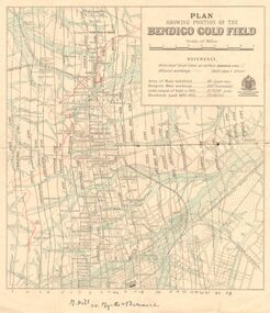 Bendigo Historical Society Inc.
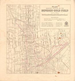
Map - DEPARTMENT OF MINES VICTORIA : PLAN SHOWING PORTION OF THE BENDIGO GOLD FIELD
Department of Mines Victoria. Plan showing portion of the Bendigo Gold Field. On the back is written, in ink, J. J. Tyler 1937 Northern Area. (He was a teacher at Bendigo High - see donation notes). Across the bottom of the map is written ' M. Hill cr. Myrtle & Barnard' .The named reef lines have been numbered with ink across the bottom of the map. The gullies have been coloured with green pencil and a red pencil line is drawn through the western side of the map. Additional information: anticlinal axial lines at surface, alluvial workings, shaft sites, area of Main Goldfield, Deepest mine workings, Gold output of field to 1935, and Dividends paid 1870 - 1935.bendigo, gold mining, bendigo gold field. gold mining. tyler, j. j. -
 Hymettus Cottage & Garden Ballarat
Photograph, Church group, 14/06/2020
This group of buildings all of which served as churches at different periods is one of the best visual demonstrations of the rapid growth of Ballarat caused by the boom years of the gold rush following the initial alluvial diggings of the 1850s. The smallest church was built in 1861 followed by the next built in 1867 and finally the construction of the grand church on the corner of Neil and Macarthur streets Soldiers' Hill in the 1890s.methodist church, uniting church, soldiers hill, ballarat. -
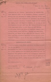 Bendigo Historical Society Inc.
Document - MISS G ALICE JONES COLLECTION: ACCOUNT
BHS CollectionGreater Gold Exploration Syndicate to Miss G. Alice Jones. Pink paper dated July 21 to Sep 17 1934, July 23 to Sep 10 1934 and 11/1/1935. Re Instructions to register firm under Business names Act as 'Victorian Alluvial Syndicate' but it was too similar to another already registered. Also application for leases. Cost £1.17.6. R599 delivered 12/1/35 JW in the top left corner.the miss g alice jones collection - account, greater gold exploration syndicate, mr h w irvine, business names act, victorian alluvial syndicate, messrs mann brown and irvine, mr terrell -
 Bendigo Historical Society Inc.
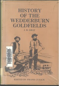
Book - HISTORY OF THE WEDDERBURN GOLDFIELDS, 1888
Gold was first discovered in 1852 on what was then named Korong or Mt Korong goldfields. It was soon found that the area was not suitable for alluvial mining because of a lack of water but quartz mining was more successful. The township of Wedderburn was surveyed 1856/57. The first public crushing works was established in 1859.Hardcover book with printed dust jacket and plastic cover. 92 pages with black and white illustrations, fold out map and index. Covers the history of the Wedderburn Goldfields and the discovery of gold generally in Australia from the 1850s until c1880s. Written by Joshua R Gray and edited by Frank Cusack.Joshua R Gray and Frank Cusack.gold, goldfields, goldfield -
 Eltham District Historical Society Inc
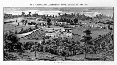
Photograph, Samuel Calvert, Eltham, The Illustrated Australian News, December 26, 1884, p212, 1884
A description in the newspaper near the illustration (page 210) reads as follows: "Eltham is a pretty little township on the Yarra Flats road, about 14 miles east north east of Melbourne, from which place there is communication by way of Heidelberg. It has a population of nearly 400 inhabitants, but in addition it is the centre of a large district extending over about 203 square miles, having a population of 2344. The land in the district is mostly used for grazing purposes, although as a rule the small farms grow a good deal of wheat, oats and other agricultural produce. A large quantity of fruit, especially raspberries and strawberries, is also produced, the rich alluvial flats along the creek upon which the township is situated being very well adapted for that purpose. Gold has also been found in the vicinity of the township, but not in remunerative quantities". This photo forms part of a collection of photographs gathered by the Shire of Eltham for their centenary project book,"Pioneers and Painters: 100 years of the Shire of Eltham" by Alan Marshall (1971). The collection of over 500 images is held in partnership between Eltham District Historical Society and Yarra Plenty Regional Library (Eltham Library) and is now formally known as 'The Shire of Eltham Pioneers Photograph Collection.' It is significant in being the first community sourced collection representing the places and people of the Shire's first one hundred years.Digital imageshire of eltham pioneers photograph collection, eltham, illustrated australian news -
Lakes Entrance Historical Society
Book, Paill Raymond, Old Walhalla- Portrait of a Gold Town, 1964
A history of the town of Walhalla victoria, from the early alluvial mining in 1860's through the heady days of rich underground mining to its rgression to a sleepy ghost town in the 1960'smines and mining, township, transport -
Bendigo Historical Society Inc.
Map - GEOLOGICAL MAP OF BENDIGO GOLD FIELD
Map of Bendigo gold field showing anticlines, synclines, shaft, alluvial deposits and contour lines. Map is in two sections. This map forms part of the Geological Survey of Victoria, Structure of Bendigo Goldfield report, No. 47, 1923. H.Herman, late Director of Geological Survey.Geological Survey Victoriabendigo, gold mining, geological map -
 Bendigo Historical Society Inc.
Memorabilia - GOLD NUGGET COLLECTION: THE GEM, 1906
The Gem The Poseidon Rush. Tarnagulla, Saturday. Article - The Albury Banner and Wodonga Express (NSW : 1871 - 1938)Friday 8 February 1907 - Page 43 The Poseidon Rush. Tarnagulla, Saturday. Several indicators and quartz leaders on the Woolshed Hill have received considerable attention during the last fortnight. In some claims the stone looks very promising, and nice tracings of gold have been obtained. Wragg Brothers struck it rich yesterday. At a depth of 12ft. on the bedrock they discovered a nugget specimen 206oz. in weight, which has been christened the 'Port Arthur. The party also had the good fortune to find two other specimens close, by, one weighing 23oz. 15dwt. and the other 24oz.These were named 'The Twins,' the Wragg Brothers bearing that distinction. In this claim about eight weeks ago the Gem (88oz.) was unearthed. THE POSEIDON RUSH. Article Illustrated - Leader (Melbourne, Vic. : 1862 - 1918, 1935)Saturday 29 December 1906 - Page 33 THE POSEIDON RUSH. It is only about five weeks since this rush was opened by John Porter, but since that time a marvellous change has taken place. The quietness of the bush has given place to a scene of wild excitement, and each week this is intensified by the discovery of large nuggets. When Smith, Rogers and Stephenson picked out their slug on election day, no one dreamed that larger ones were lying only a few feet away, but such was the fact. On Tuesday afternoon two immense slugs, one of which weighed 960 oz., and the other 373 oz., were found in adjoining claims within a few minutes of each other. The finding of these created a scene which it is difficult to describe. "I've got one, “was shouted from the claim of Bert Williamson and T. Stephenson, two men just entering into manhood. They were seen excitedly digging round a lump of gold, one of them with a double-ended pick, the point-of which he broke in his anxiety to unearth it. This slug is nine inches long by seven inches by 43 inches, and is very similar in appearance and size to the big nugget got previously in the adjoining claim. It has been cleaned and smelted, and has yielded 306 oz. of pure gold of the best sample. Before the excitement caused by the discovery of the last nugget had sub-sided, there was a shout from an adjoining claim. Sam Woodall, a Llanelly miner, felt his pick strike a hard yielding sub-stance, and, satisfied that he had struck a nugget, called the attention of his mates to the fact. He soon levered it out of the ground with his pick. Taking it up in his arms he staggered out of the claim with it, and in a minute or two was sur-rounded by hundreds of men who rushed from all over the field to view it, and to feel its weight. It was certainly a magnificent specimen, and the fortunate miners were congratulated on all sides. Its weight was guessed to be a hundredweight, and probably in its then dirty state it would nave turned the scales at that. In a few minutes the crowd was so dense that it was impossible to get a close inspection. The nugget was first taken to Newbridge under escort, then through Llanelly to Tarnagulla, where it was lodged in the Union Bank. It was found that the bank scales were not sufficiently large to weigh the mass. By tying a number of large weights together, and suspending them from a steel bar, a fairly accurate weight was obtained, and it just balanced 80 lb., or 960 oz. The nugget measures 16 in. x 10 in. x 5 in. The party was cheered as it drove up the main street here, and the sight of an armed escort was quite a novelty. The nugget was held aloft in a tin dish for inspection by the crowd. These nuggets were found in the shallow workings, and neither of them were a foot under the surface. The ground is a black loamy soil; there was no appearance of wash whatever, and no one knowing anything of alluvial mining would think of searching for gold in such a spot. All those who have claims on the hillside are breaking out all the dirt in a face from the surface to the reef, which is a mixture of lime and sunstone, and searching for nuggets. The ground is carefully pulverised so that nothing shall be missed. Some are puddling the whole of it, but it is hardly payable. Where the big nuggets are now being found, the ground has been pegged out and abandoned more than once since the rush started, and shares in the claims have been purchased for small amounts. Smith was given a third share in the claim where the first nugget was found for puddling the dirt big lump was discovered, by Woodall, Condron, Brooks and Eva, two of them sold a sixth share for £5 a few days ago to a man named Woods, who only worked a few days and sold out again for 50/. Some fancy prices are now being offered for shares in the claims in the vicinity. Woodall holds a third share, Condron and Brooks three-quarters of a share each, and Eva a sixth share. The largest nugget has been christened "The Poseidon." The names given to the other nuggets obtained previously are as follow: — Wragg Bros., 88 oz. nugget, "The Gem"; Smith and party's 378 oz. nugget, which was unearthed on election day, has been fittingly named "The Federal"; Jackson and Hughes 152 oz.specimen, "The Little. Beu"; Williamson and Stephenson's 373 oz. nugget is said to be called "The Christmas Box." A representative from the (Mines department has been at the bank during, the week taking models for the museums and schools of mines. )A replica of the "Gem" gold nugget that was discovered on 29.11.1906 on the Poseidon Lead at Tarnagulla at the depth of 9 feet. Found on the bedrock by the Wragge Bros. Weight 88 ozs. Value of $126,358 in 2016. (See additional Research.)mining, models, plaster model of victorian gold nugget -
 Buninyong & District Historical Society
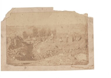
Photograph - B/W photograph of shallow alluvial mine, Sepia mining scene
... This photograph of miners at work on a shallow alluvial ...This photograph of miners at work on a shallow alluvial mine was taken around 1870 however the location, participants and precise date are unknownThis scene is typical of alluvial mining during the gold rush and up to the latter part of the 19th century showing gold miners and their equipment in actionSepia photograph of shallow mine with six miners location unknown c 1870Alluvial Mining late 19th centurygold mining, miners, tramway -
Bendigo Historical Society Inc.
Document - Return of Gold Mines 1859, 1876
Four page photocopy document 'Legislative Assembly 1859, Return of gold mine leases'. Information detailed includes: lessee; name of company; gold field; mining district; description of lease (alluvial/quartz) area; term; annual rent; capital, machinery value; minimum number of men to be employed. Example: Union Co., Sheepshead Gully, quartz mine, area 3 roods, and 22 perches, term 10 years, amount of rent 4 pounds 8 shillings and ninepence, capital 4,000 pounds, machinery 3,000 pounds, minimum amount of men to be employed - 2. Names of mine lessees: W. Tongue, R. Lysle, G. Nevison, T. Porter, J. Griston. mining, sandhurst, mining leases, labour convenant, union co., sheepshead gully, quartz mine, legislative assembly, return of gold mines, -
 Bendigo Historical Society Inc.
Document - VICTORIA HILL - THE BENDIGO DIGGINGS, PRELIMINARY DRAFT FOR BROCHURE
BHS CollectionNine typed pages of notes on a preliminary draft for a brochure on the Bendigo Diggings. First part is the objective which is to preserve the mining history and to have exhibits in the places they were used, e.g. quartz mining machinery exhibited in a quartz mining area, not on an alluvial field. Part B is historical notes on the area. Part C is the Site - Victoria Hill area. Part D is Stage One which consists of carpark area, technological museum, restaurant, mineral haulage line, picnic ground, earthworks and planting over the area. Part E is Stage Two which will consist of the open-air exhibits, in the area surrounded by the mineral haulage line, and the Central Nell Gwynne mine on the west side of the site. Part F is Stage Three which will consist of the winery, the steam tram track, the lake, the wildlife sanctuary and various buildings associated with gold mining. Part G is Costing with the prices to be filled in. Parts H and I are the Appeal and the Committee. Details to be filled in. Notes prepared by Albert Richardson.mining, marketing, victoria hill, victoria hill, the bendigo diggings - preliminary draft for brochure, aust national travel association, tullamarine jetport, emu bottom homestead, kyneton historical museum, chinese joss house, eaglehawk museum, whipstick scrub, cairn curran reservoir, castelmaine historical museum and market hall, national trust, ballarat hiatorical park, echuca's hopwood gardens, swan hill folk museum, gibson's mount alexander no 2 squatting run, captain brown, chief commissioner wright, hustler's reef, thomas hustler, mining board, drainage of reefs act 1862, first world war, bendigo amalgamated goldfields, second world war, sandhurst, w c vahland, battery trams, horse trams, steam trams, electric trams, central nell gwynne mine, theodore ballerstadt, george lansell, new chum hill, ballerstadt's open cut, 180 mine, new chum syncline battery, william rae, victoria quartz, wittscheibe's 'jeweller's shop', luffsman and sterry, gold mines hotel, adventure, bendigo and district tourist association, bendigo city council, bendigo branch of the royal historical society of victoria, professor brian lewis, school of architecture and building at the university of melbourne, taylor horsfield, lord robert cecil, south australian gold commissioner -
 Bendigo Historical Society Inc.
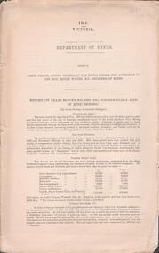
Document - GARDEN GULLY LINE OF REEF, LEASE BLOCKS 5360 AND 5361
Two page document titled ' Report on lease blocks Nos. 5360 and 5361 Garden Gully line of reef, Bendigo. Produced by the Department of Mines 1899. The area described is about 'one mile and a quarter southeast from the centre of the city of Bendigo, immediately south of the Great Southern Gold Mining Company's workings and is intersected by two auriferous gullies ... Salomon's Gully and Derwenter's Gully'. The alluvial deposits, the Garden Gully line, the Great Souther Co.and old workings are discussed in the paper. A map of the Garden Gully line of reef is attached to the report, showing claimholders and mine names along that section of the reef. Mines named on the map: Great Southern Garden Gully United Ulster Londonderry Burrows Horwoods Sea Amalgamated Garden Gully United Victory and Pandora Unity Carlisle and Garden Gully and Passbye United Cornish United Koch's PioneerJames Stirling, Government Geologistbendigo, mining, garden gully line of reef mines -
 Bendigo Historical Society Inc.
Document - LISTS OF ITEMS AUCTIONED AT BENDIGO MINES
Typed copies of catalogues of items to be auctioned at the following mines: South Red, White and Blue 12th April 1938 Central Blue 28th October, 1941 at 11 a.m South Virginia Extended (found inside Central Blue catalogue) Big Blue 21st November, 1939 at 10.30 a.m Golden Transverse Bendigo 3rd September 1941Yandoit Co 19th April 1939 Chapman's Gold Mine Chewton 8th February 1939 Ross Creek Extended G.M. Coy 18th August 1938 Ross Creek Extended G.M.Coy Ross Creek Mines Account Mines Dept Pitfield Plains, Glenfine South Shaft Adelong Dredge and leases 10th February 1943 Bright Valley Dredge 9,10th February 1943 Exchequer Extended North Chewton 18th October, 1939 Talbot Alluvials Norbury's No. 2 shaft 5th May 1941 Gordon Gold Mine Inglewood 30th April 1940 Postg Office Hill Mine Chewton 7th February 1940 Carlisle & Whittaker Plant Buninyong Rand Yandoit Mine North Chewton 19th October 1939 Spring Gully Mine Chewton 14th Decembert 1938 Eureka Central Chewton 26th February 1941The Golod Mine Clunes 15th March 1941 Guildford Plateau 20th Novemer 1940 New Long Tunnel Walhalla 12th February 1941 Napoleon BML 28th October 1941 Alfords Battery Hercules No. 1 Mine 12th February 1942 Ramrod Gold Mine Bendigo 19th March 1942 Bendigo Amalgamated Goldfields Limited 10th and 11th August 1938 Virginia South Extended 1st June 1938 -
 Bendigo Historical Society Inc.
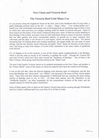
Slide - DIGGERS & MINING. DIGGERS AND MINERS, c1850s
BHS CollectionDiggers & Mining. Diggers and miners. On many fields, even the surface alluvial deposits had been worked out, there was still much gold to be got, but it lay in the deeper strata - - - Markings: 21 994:LIF I. Used as a teaching aid.hanimounteducation, tertiary, goldfields -
 Bendigo Historical Society Inc.
Document - NEW CHUM & VICTORIA LINES OF REEF - NOTES ON THE VICTORIA REEF GOLD MINES COY
Handwritten notes describing the journey along Eaglehawk Road from the houses, poppet heads and mine tailings, etc. When the alluvial diggings were showing signs of exhaustion, and the fear arose that Bendigo was 'about done', two 'darkies' One named Dido, struck golden stone. They sold out to Ballerstedt and Son, and thus gold mining was revived. These areas were remarkable for the extraordinary richness of the lodes, and the singular manner in which the gold is distributed.document, gold, new chum & victoria lines of reef, notes on the victoria reef gold mines coy, gavan duffy, victoria hill, black lead, prince alfred, ballerstadt & son, goldfields registry, mr macartney, wittscheibe, luffsman -
 Bendigo Historical Society Inc.
Map - BENDIGO GOLD FIELD - MAP OF PORTION OF THE BENDIGO GOLD FIELD
... Map showing portion of the Bendigo Gold Field showing...DOCUMENT Bendigo Gold Field Department of Mines Lines ...Map showing portion of the Bendigo Gold Field showing Alluvial working, shaft sites , streets and lines of reefs.Department of Mines, Victoria. Many mines, lines of reefs and gullies are on the map. Blue Royal Historical Society of Victoria Bendigo Branch stamp on the back.document, bendigo gold field, department of mines, lines of reefs, gullies, mines -
 Bendigo Historical Society Inc.
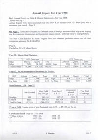
Document - MINING REPORTS - YIELDS FROM ALLUVIAL & QUARTZ REEFS 1897
Handwritten notes give details of alluvial, and quartz yields from the Sandhurst and Eaglehawk gold fields. Ref. Sec. Mines Report 1897, Page 13. Also, a report from the Sec. Mines Report1905 Pages 116 & 117 mentioning the number of men employed at Kochs Pioneer, Confidence Ex'td, North Johnsons and Princess Dagmar Mines. Report by G Hawke, Acting Inspector of Mines E'Hawk No 10 Dist.document, gold, mining reports, yields from alluvial & quartz reefs 1897, sandhurst gold field, g hawke, kochs pioneer, confidence ex'td, north johnsons, princess dagmar -
 The Beechworth Burke Museum
Photograph
This image is a reproduction of an 1899 original depicting the 'Williams Good Luck Mine' on the Mopoke Reef (also called 'Morepork Gully') in the Dingle Ranges, approximately three miles from Beechworth. A large opening to a mine can be seen behind the men in the photograph, with a wheeled cart on a track leading to the men's position, where the soil and rocks have been hauled away. This photograph interestingly contains dogs alongside the miners. While dogs have been recorded as deterrents to thieves in the Victorian goldfields, these dogs appear as companions to these men. Following the discovery of gold at Beechworth in 1852, rushes quickly followed at surrounding creeks and gullies in the district. In the late nineteenth and early twentieth centuries, small syndicates of miners continued to work old or abandoned quartz reefs, often persisting without the assistance of heavy machinery to remove the large amounts of rock, in order to obtain yields at ever greater depths. The group of miners in this photograph are Mr. Roger Williams and Sons, who revived operations at the ‘Old Good Luck’ mine on the Mopoke Reef in the Dingle Range near Beechworth around 1892, working the site for more than two decades. An emigrant from Cornwall with experience in the tin mining industry, 19 year old Roger Williams senior sailed to New Zealand in 1840, then to Australia where he spent time in the Bendigo Gold Fields before settling in Beechworth in the early 1860s. Mr Williams senior worked on various mining activities in the district, including the Rocky Mountain Tunnel project. Conversant with the character of gold-bearing reefs in the area, the syndicate dug an eight hundred foot tunnel, digging down as far down as two hundred feet with little capital save their labour, to connect and provide better working access to the mass of reefs and veins in the vicinity. Progress was hampered by poor air quality charged with fumes from dynamite and large quantities of rock had to be crushed to obtain payable yields. The Victorian Goldfields are filled with ruins and remnants of the area's rich mining history, ranging from small alluvial diggings to the remains of huge mining companies. Site names often changed several times throughout the nineteenth and twentieth centuries. Some sites were abandoned and forgotten, others were worked continuously over many decades. The names of mines were often repeated at different locations throughout the Victorian Goldfields. For example, there is a Mopoke Gully heritage mine near Fryers Creek, Victoria. 'Mopoke' is a common onomatopoeic name for Morepork and Australian Boobook owls.This image has historical, social and research significance for patterns of emigration during of the Victorian Gold Rush, and the historical, social and environmental impacts of mining at Beechworth at the turn of the nineteenth and twentieth centuries. As gold became scarce and government support and large company investment waned, poor hard-working miners laboured intensively to make a living through periods of high unemployment. This image can be compared and studied alongside other historical mining photographs and objects in the Burke Museum Collection. It has potential to improve our understanding of miners working conditions and the shifting character of mining in the Beechworth district.Sepia coloured rectangular photograph printed on gloss photographic paper mounted on card. Obverse: Williams/ Good/ Luck Reverse: A02498/ 1997. 2498/ Good Luck/ Mine/ 1899/ Mopoke. burke museum, beechworth museum, beechworth, gold fields, gold rush, victorian gold rush, gold ming history, colonial australia, australian gold rushes, mining technology, beechworth historic district, indigo gold trail, migration, indigo shire, good luck gold mine, victorian goldfields, mining syndicates, gold fever, quartz-mining, small-scale mining, old good luck mine, mopoke gully, quartz reefs beechworth -
 The Beechworth Burke Museum
Photograph
This image is a reproduction of an 1899 original depicting the 'Williams Good Luck Mine' on the Mopoke Reef (also called 'Morepork Gully') in the Dingle Ranges, approximately three miles from Beechworth. The foreground of the image is littered with piles of smashed rock and detritus, known as ‘mullock’, beside a reinforced mine shaft, a vertical access passageway allowing miners to enter the mine and haul ore out using lifting technology such as a poppet heads, whims or windlasses. A group of miners and a dog appear close to an open-sided miner’s hut. Following the discovery of gold at Beechworth in 1852, rushes quickly followed at surrounding creeks and gullies in the district. In the late nineteenth and early twentieth centuries, small syndicates of miners continued to work old or abandoned quartz reefs, often persisting without the assistance of heavy machinery to remove the large amounts of rock, in order to obtain yields at ever greater depths. The group of miners in this photograph are Mr. Roger Williams and Sons, who revived operations at the ‘Old Good Luck’ mine on the Mopoke Reef in the Dingle Range near Beechworth around 1892, working the site for more than two decades. An emigrant from Cornwall with experience in the tin mining industry, 19 year old Roger Williams senior sailed to New Zealand in 1840, then to Australia where he spent time in the Bendigo Gold Fields before settling in Beechworth in the early 1860s. Mr Williams senior worked on various mining activities in the district, including the Rocky Mountain Tunnel project. Conversant with the character of gold-bearing reefs in the area, the syndicate dug an eight hundred foot tunnel, digging down as far down as two hundred feet with little capital save their labour, to connect and provide better working access to the mass of reefs and veins in the vicinity. Progress was hampered by poor air quality charged with fumes from dynamite and large quantities of rock had to be crushed to obtain payable yields. The Victorian Goldfields are filled with ruins and remnants of the area's rich mining history, ranging from small alluvial diggings to the remains of huge mining companies. Site names often changed several times throughout the nineteenth and twentieth centuries. Some sites were abandoned and forgotten, others were worked continuously over many decades. The names of mines were often repeated at different locations throughout the Victorian Goldfields. For example, there is a Mopoke Gully heritage mine near Fryers Creek, Victoria. 'Mopoke' is a common onomatopoeic name for Morepork and Australian Boobook owls.This image has historical, social and research significance for patterns of emigration during of the Victorian Gold Rush, and the historical, social and environmental impacts of mining at Beechworth at the turn of the nineteenth and twentieth centuries. As gold became scarce and government support and large company investment waned, poor hard-working miners laboured intensively to make a living through periods of high unemployment. This image can be compared and studied alongside other historical mining photographs and objects in the Burke Museum Collection. It has potential to improve our understanding of miners working conditions and the shifting character of mining in the Beechworth district.Sepia coloured rectangular photograph printed on gloss photographic paper mounted on card.Obverse: Reverse: A02497/ 1997.2497/ 'Good/ Luck/ Mine'/ Morepork/ Gully/ Mrs Joyce/ Bright/ Tunnel/ 800 ft/ 1899. burke museum, beechworth museum, beechworth, gold fields, gold rush, victorian gold rush, gold ming history, colonial australia, australian gold rushes, mining technology, beechworth historic district, indigo gold trail, migration, indigo shire, good luck gold mine, victorian goldfields, mining syndicates, gold fever, quartz-mining, small-scale mining, old good luck mine, mopoke gully, quartz reefs beechworth -
Clunes Museum
Map, DEPARTMENT OF MINES, Untitled, c1859
All maps show names and locations of mines operating in the district (see reference section link to article).1 Map of Creswick Clunes - lists 45 mines in the Clunes enlargement and 100 mines in the Creswick enlargement .2 Department of Mines map of Clunes Creswick and shows the McDonald & Co. Pre-emptive area. Indexes for quartz and alluvial mine locations .3 Topographical map Ref GF23 Clunes Mt. Greenock Talbot.1 360 Scale 1:2500 .2 303/59 33 hand written in ink "received 15 October 1859" signed by R Broughton, James Stevenson - District Mining Surveyor .3 40 chains to an Inchgold mining, dept of mines -
 Bendigo Historical Society Inc.
Document - MINING REPORTS - ANNUAL REPORT INC GOLD & MINERAL STATISTICS ETC 1938
... mentioned are District Gold Statistics for alluvial and quartz... are District Gold Statistics for alluvial and quartz mining, No. of men ...handwritten notes from the Annual Report. Mines mentioned ae: Central Nell Gwynne, Deborah, New Chum Syncline and the South Virginia. Carshalton B. M. L. closed down. Also mentioned are District Gold Statistics for alluvial and quartz mining, No. of men employed in mining in Bendigo. Also mentioned are tons crushed, gold yield, fees rec'd, concessions allowed and free trial crushings at the State Battery for Bendigo and Eaglehawk. The London price of gold per ounce is mentioned and also the number of 1st class and 2nd class e' driver Certificate issued for the years 1937 and 1938.Albert Richardsondocument, gold, mining reports, annual repport inc gold & mineral statistics etc 1938, central nell gwynne, deborah, new chum yncline, south virginia, carshalton b m l, state battery -
 Bendigo Historical Society Inc.
Document - AUCTION SALES - MINING CATALOGUE AUCTION SALES
BHS CollectionYellow and white patterned, spring back Spirax Students No. 594 Note Book containing extracts from mining Catalogues loaned by Mr. Dyett (J. H. Curnow's). Mines mentioned include Ramrod Gold Mine, Hercules No. 1, Central Blue, South Virginia Extended, Alfords Battery, South New Moon,The Gold Mine Clunes, Guildford Plateau, Big Blue, Spring Gully Mine at Chewton, Eureka Central at Chewton, Bdgo Amalg. Goldfields Limited, Koch's Air Station, Cornish Mine, Carlisle Battery, Victory & Pandora Mine, Garden Gully, Londonderry Mine, Princess Dagmar, Golden Age, Suffolk United, Virginia South Extended, South Red White & Blue, Pitfield Plains Glenfine South Shaft, Adelong Dredge & Leases, Bright Valley Dredge, North Chewton (Chewton), Talbot Alluvials Norbury's No. 2 Shaft, Gordon Gold Mine Inglewood, Post Office Hill Mine Chewton, Carlisle & Whittaker Plant Maldon, Bunninyong, Yandoit Mine, North Chewton, Golden Transverse Bdgo, Yandoit Co., Chapman's Gold Mine Chewton, Ross Creek Extended G. M. Coy (Ballarat).book, bendigo, mining auction sales, auction sales mining catalogue auction sales, j h curnow, mr dyett, a richardson, ramrod gold mine, hercules no. 1, central blue, south virginia extended, alfords battery, south new moon, the gold mine clunes, guildford plateau, big blue, spring gully mine at chewton, eureka central at chewton, bdgo amalg. goldfields limited, koch's air station, cornish mine, carlisle battery, victory & pandora mine, garden gully, londonderry mine, princess dagmar, golden age, suffolk united, virginia south extended, south red white & blue, pitfield plains glenfine south shaft, adelong dredge & leases, bright valley dredge, north chewton (chewton), talbot alluvials norbury's no. 2 shaft, gordon gold mine inglewood, post office hill mine chewton, carlisle & whittaker plant maldon, bunninyong, yandoit mine, north chewton, golden transverse bdgo, yandoit co., chapman's gold mine chewton, ross creek extended g. m. coy (ballarat).