Showing 97 items matching "alluvial mine"
-
 Bendigo Historical Society Inc.
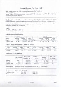
Document - MINING REPORTS - ANNUAL REPORT INC GOLD & MINERAL STATISTICS ETC 1938
handwritten notes from the Annual Report. Mines mentioned ae: Central Nell Gwynne, Deborah, New Chum Syncline and the South Virginia. Carshalton B. M. L. closed down. Also mentioned are District Gold Statistics for alluvial and quartz mining, No. of men employed in mining in Bendigo. Also mentioned are tons crushed, gold yield, fees rec'd, concessions allowed and free trial crushings at the State Battery for Bendigo and Eaglehawk. The London price of gold per ounce is mentioned and also the number of 1st class and 2nd class e' driver Certificate issued for the years 1937 and 1938.Albert Richardsondocument, gold, mining reports, annual repport inc gold & mineral statistics etc 1938, central nell gwynne, deborah, new chum yncline, south virginia, carshalton b m l, state battery -
 Clunes Museum
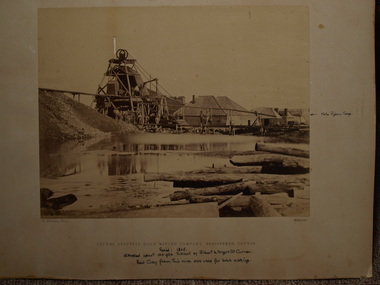
Photograph, C. NETTLETON, APPROX. 1865
THIS MINE WAS SITUATED ABOUT 100 YARDS SOUTH WEST OF ALBERT STREET AND ANGUS STREET CORNER. RED CLAY FROM THIS MINE WAS USED FOR BRICK MAKING..1 SEPIA PHOTOGRAPH OF CLUNES ALLUVIAL GOLD MINING CO. .2 SEPIA PHOTOGRAPH OF POPPET HEAD-MINERS ON PLATFORM-THATCHED ROOF BUILDINGS, SCATTERING OF LARGE LOGS IN FOREGROUND, USED FOR FIRES. .3 COPY OF ABOVE PHOTOGRAPH IN BLACK AND WHITE (POSTCARD SIZE).1 PRINTED: CLUNES ALLUVIAL GOLD MINING COMPANY REGISTERED CLUNES .2 PRINTED ON FRONT : ALLUVIAL GOLD MINING COMPANY REGISTERED CLUNES HANDWRITTEN: PERIOD 1865. SITUATED ABOUT 100 YDS SW OF ALBERT AND ANGUS STREET CORNER. RED CLAY FROM THIS MINE WAS USED FOR BRICK MAKINGphotographs, mining, clunes alluvial mining company -
 Bendigo Historical Society Inc.
Document - NEW CHUM & VICTORIA LINES OF REEF - NOTES ON THE VICTORIA REEF GOLD MINES COY
Handwritten notes describing the journey along Eaglehawk Road from the houses, poppet heads and mine tailings, etc. When the alluvial diggings were showing signs of exhaustion, and the fear arose that Bendigo was 'about done', two 'darkies' One named Dido, struck golden stone. They sold out to Ballerstedt and Son, and thus gold mining was revived. These areas were remarkable for the extraordinary richness of the lodes, and the singular manner in which the gold is distributed.document, gold, new chum & victoria lines of reef, notes on the victoria reef gold mines coy, gavan duffy, victoria hill, black lead, prince alfred, ballerstadt & son, goldfields registry, mr macartney, wittscheibe, luffsman -
 Bendigo Historical Society Inc.
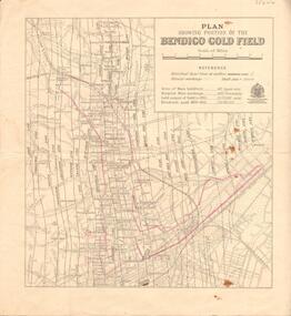
Map - BENDIGO GOLD FIELD - MAP OF PORTION OF THE BENDIGO GOLD FIELD
Map showing portion of the Bendigo Gold Field showing Alluvial working, shaft sites , streets and lines of reefs.Department of Mines, Victoria. Many mines, lines of reefs and gullies are on the map. Blue Royal Historical Society of Victoria Bendigo Branch stamp on the back.document, bendigo gold field, department of mines, lines of reefs, gullies, mines -
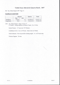 Bendigo Historical Society Inc.
Document - MINING REPORTS - YIELDS FROM ALLUVIAL & QUARTZ REEFS 1897
Handwritten notes give details of alluvial, and quartz yields from the Sandhurst and Eaglehawk gold fields. Ref. Sec. Mines Report 1897, Page 13. Also, a report from the Sec. Mines Report1905 Pages 116 & 117 mentioning the number of men employed at Kochs Pioneer, Confidence Ex'td, North Johnsons and Princess Dagmar Mines. Report by G Hawke, Acting Inspector of Mines E'Hawk No 10 Dist.document, gold, mining reports, yields from alluvial & quartz reefs 1897, sandhurst gold field, g hawke, kochs pioneer, confidence ex'td, north johnsons, princess dagmar -
 The Beechworth Burke Museum
Photograph
This image is a reproduction of an 1899 original depicting the 'Williams Good Luck Mine' on the Mopoke Reef (also called 'Morepork Gully') in the Dingle Ranges, approximately three miles from Beechworth. A large opening to a mine can be seen behind the men in the photograph, with a wheeled cart on a track leading to the men's position, where the soil and rocks have been hauled away. This photograph interestingly contains dogs alongside the miners. While dogs have been recorded as deterrents to thieves in the Victorian goldfields, these dogs appear as companions to these men. Following the discovery of gold at Beechworth in 1852, rushes quickly followed at surrounding creeks and gullies in the district. In the late nineteenth and early twentieth centuries, small syndicates of miners continued to work old or abandoned quartz reefs, often persisting without the assistance of heavy machinery to remove the large amounts of rock, in order to obtain yields at ever greater depths. The group of miners in this photograph are Mr. Roger Williams and Sons, who revived operations at the ‘Old Good Luck’ mine on the Mopoke Reef in the Dingle Range near Beechworth around 1892, working the site for more than two decades. An emigrant from Cornwall with experience in the tin mining industry, 19 year old Roger Williams senior sailed to New Zealand in 1840, then to Australia where he spent time in the Bendigo Gold Fields before settling in Beechworth in the early 1860s. Mr Williams senior worked on various mining activities in the district, including the Rocky Mountain Tunnel project. Conversant with the character of gold-bearing reefs in the area, the syndicate dug an eight hundred foot tunnel, digging down as far down as two hundred feet with little capital save their labour, to connect and provide better working access to the mass of reefs and veins in the vicinity. Progress was hampered by poor air quality charged with fumes from dynamite and large quantities of rock had to be crushed to obtain payable yields. The Victorian Goldfields are filled with ruins and remnants of the area's rich mining history, ranging from small alluvial diggings to the remains of huge mining companies. Site names often changed several times throughout the nineteenth and twentieth centuries. Some sites were abandoned and forgotten, others were worked continuously over many decades. The names of mines were often repeated at different locations throughout the Victorian Goldfields. For example, there is a Mopoke Gully heritage mine near Fryers Creek, Victoria. 'Mopoke' is a common onomatopoeic name for Morepork and Australian Boobook owls.This image has historical, social and research significance for patterns of emigration during of the Victorian Gold Rush, and the historical, social and environmental impacts of mining at Beechworth at the turn of the nineteenth and twentieth centuries. As gold became scarce and government support and large company investment waned, poor hard-working miners laboured intensively to make a living through periods of high unemployment. This image can be compared and studied alongside other historical mining photographs and objects in the Burke Museum Collection. It has potential to improve our understanding of miners working conditions and the shifting character of mining in the Beechworth district.Sepia coloured rectangular photograph printed on gloss photographic paper mounted on card. Obverse: Williams/ Good/ Luck Reverse: A02498/ 1997. 2498/ Good Luck/ Mine/ 1899/ Mopoke. burke museum, beechworth museum, beechworth, gold fields, gold rush, victorian gold rush, gold ming history, colonial australia, australian gold rushes, mining technology, beechworth historic district, indigo gold trail, migration, indigo shire, good luck gold mine, victorian goldfields, mining syndicates, gold fever, quartz-mining, small-scale mining, old good luck mine, mopoke gully, quartz reefs beechworth -
 The Beechworth Burke Museum
Photograph
This image is a reproduction of an 1899 original depicting the 'Williams Good Luck Mine' on the Mopoke Reef (also called 'Morepork Gully') in the Dingle Ranges, approximately three miles from Beechworth. The foreground of the image is littered with piles of smashed rock and detritus, known as ‘mullock’, beside a reinforced mine shaft, a vertical access passageway allowing miners to enter the mine and haul ore out using lifting technology such as a poppet heads, whims or windlasses. A group of miners and a dog appear close to an open-sided miner’s hut. Following the discovery of gold at Beechworth in 1852, rushes quickly followed at surrounding creeks and gullies in the district. In the late nineteenth and early twentieth centuries, small syndicates of miners continued to work old or abandoned quartz reefs, often persisting without the assistance of heavy machinery to remove the large amounts of rock, in order to obtain yields at ever greater depths. The group of miners in this photograph are Mr. Roger Williams and Sons, who revived operations at the ‘Old Good Luck’ mine on the Mopoke Reef in the Dingle Range near Beechworth around 1892, working the site for more than two decades. An emigrant from Cornwall with experience in the tin mining industry, 19 year old Roger Williams senior sailed to New Zealand in 1840, then to Australia where he spent time in the Bendigo Gold Fields before settling in Beechworth in the early 1860s. Mr Williams senior worked on various mining activities in the district, including the Rocky Mountain Tunnel project. Conversant with the character of gold-bearing reefs in the area, the syndicate dug an eight hundred foot tunnel, digging down as far down as two hundred feet with little capital save their labour, to connect and provide better working access to the mass of reefs and veins in the vicinity. Progress was hampered by poor air quality charged with fumes from dynamite and large quantities of rock had to be crushed to obtain payable yields. The Victorian Goldfields are filled with ruins and remnants of the area's rich mining history, ranging from small alluvial diggings to the remains of huge mining companies. Site names often changed several times throughout the nineteenth and twentieth centuries. Some sites were abandoned and forgotten, others were worked continuously over many decades. The names of mines were often repeated at different locations throughout the Victorian Goldfields. For example, there is a Mopoke Gully heritage mine near Fryers Creek, Victoria. 'Mopoke' is a common onomatopoeic name for Morepork and Australian Boobook owls.This image has historical, social and research significance for patterns of emigration during of the Victorian Gold Rush, and the historical, social and environmental impacts of mining at Beechworth at the turn of the nineteenth and twentieth centuries. As gold became scarce and government support and large company investment waned, poor hard-working miners laboured intensively to make a living through periods of high unemployment. This image can be compared and studied alongside other historical mining photographs and objects in the Burke Museum Collection. It has potential to improve our understanding of miners working conditions and the shifting character of mining in the Beechworth district.Sepia coloured rectangular photograph printed on gloss photographic paper mounted on card.Obverse: Reverse: A02497/ 1997.2497/ 'Good/ Luck/ Mine'/ Morepork/ Gully/ Mrs Joyce/ Bright/ Tunnel/ 800 ft/ 1899. burke museum, beechworth museum, beechworth, gold fields, gold rush, victorian gold rush, gold ming history, colonial australia, australian gold rushes, mining technology, beechworth historic district, indigo gold trail, migration, indigo shire, good luck gold mine, victorian goldfields, mining syndicates, gold fever, quartz-mining, small-scale mining, old good luck mine, mopoke gully, quartz reefs beechworth