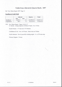
Showing 116 items matching "alluvial mining"
-
 Bendigo Historical Society Inc.
Slide - DIGGERS & MINING: DIGGERS & MINING
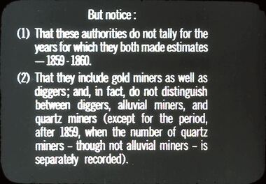
Diggers & Mining: Diggers & Mining. Slide reads; But notice: (1) That these authorities do not rally for the years for which they both made estimates - 1859 - 1860. (2) That they include gold miners as well as diggers; and, in fact, do not distinguish between diggers, alluvial miners, and quartz miners (except for the periods after 1859, when the number of quartz miners - though not alluvial miners - is separately recorded). Markings: 50/ 994:LIF 1. Used as a teaching aid.hanimounteducation, tertiary, mining -
 Bendigo Historical Society Inc.
Document - MCCOLL, RANKIN AND STANISTREET COLLECTION: SUNDRY REPORTS, 1930's
Manilla Folder containing reports from various mines in Bendigo and surrounding areas. 1. 4 page typewritten report on the Balaclava Hill Mine at Rushworth and some newspaper clippings about the mine with a plan of the underground workings; 2. Page from the Árgus' dated 2nd August 1900 featuring an article on the survey of the Garden line of Reefs; 3. 5 page report with maps on the Tooleen Gold Field; 4. Single page report about an unnamed mining area claimed to be on the southern end of the Deborah line of reef. (this could be the 'Three Jays' mine in Sedgwick. P. Wilkin); 5. Hand written report on the Coronation Mine, 2 miles east of Walhalla.; 6. Hand written report dated 1935, of the Queen Mary mine, St. Arnaud.; 7. 1932 report on the North Neangar lease.; 8 4 page report on the Kings Prize Gold Mining Syndicate.; 9. Description of the plant of the Marong Alluvial Company? Also a guide for marking out leases.; 10. Crushing details (1 page) from the 'Enterprise' Mine South of and adjacent to Perseverence.; 11. 1 page crushing details from Rowe Brothers, Mosquito Mine, Fryerstown.; 12 hand written report mentions Arthur Hatfield, Scarsdale.; 13. Map with lines of reef showing the position of the New Moon Consolidated and the New Moon United shafts.; 14, Large scale map from Harrison/Victoria street to Havilah Road showing the positions of the Carlisle, North Garden and Unity Shafts.gold mining, miners' safety cage, sundry reports, mining. bendigo, rushworth, balaclava hill, garden line of reef, toolleen, coronation mine, walhalla, queen mary mine, st. arnaud. north neangar, kings prize gold mining syndicate, marong, enterprise mine, perseverence, rowe brothers, mosquito mine, fryerstown, arthur hatfield, scarsdale, new moon consolidate, new moon united, carlisle, north garden, unity. -
![View of the Township of Mt. Blackwood / [by] Nicholas Caire, circa 1876](/media/collectors/550653872162f11fb04854aa/items/57830cfbd0cdd1176c424e00/item-media/57830d7ad0cdd1176c428423/item-fit-380x285.jpg) Kew Historical Society Inc
Kew Historical Society IncPhotograph, Anglo-Australasian Photographic Company, View of the Township of Mt. Blackwood, c. 1876
... the scene of considerable mining activity. The shallow alluvial..., and has been the scene of considerable mining activity ...Nicholas Caire was born on Guernsey in the Channel Islands in 1837. He arrived in Adelaide with his parents in about 1860. In 1867, following photographic journeys in Gippsland, he opened a studio in Adelaide. From 1870 to 1876 he lived and worked in Talbot in Central Victoria. In 1876 he purchased T. F. Chuck's studios in the Royal Arcade Melbourne. In 1885, following the introduction of dry plate photography, he began a series of landscape series, which were commercially successful. As a photographer, he travelled extensively through Victoria, photographing places few of his contemporaries had previously seen. He died in 1918. Reference: Jack Cato, 'Caire, Nicholas John (1837–1918)', Australian Dictionary of Biography.An original, rare photograph from the series 'Views of Victoria: General Series' by the photographer, Nicholas Caire (1837-1918). The series of 60 photographs that comprise the series was issued c. 1876 and reinforced a neo-Romantic view of the Australian landscape to which a growing nationalist movement would respond. Nicholas Caire was active as a photographer in Australia from 1858 until his death in 1918. His vision of the Australian bush and pioneer life had a counterpart in the works of Henry Lawson and other nationalist poets, authors and painters.‘View of the Township of Mt. Blackwood’ : Views of Victoria (General Series) No.42 : Albumen silver photograph | Photo on card with Title and Description on reverse | Mounted 24 x 30 cm; Photo 12 x 17 cm.On Reverse: ‘The locality which this illustration represents was formerly known as the Blackwood Forest, and has been the scene of considerable mining activity. The shallow alluvial diggings of the early days have given place to the deep sinking in search of reefs. This scene is characteristic of the wild appearance which many of the inland townships of Victoria represent.’nicholas caire (1837-1918), blackwood (vic), mount blackwood, landscape photography - victoria -
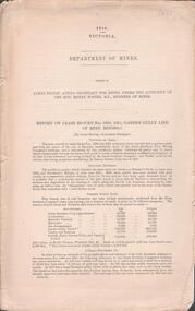
 Tarnagulla History Archive
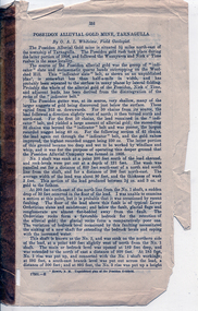
Pages from a book: Poseidon Alluvial Gold Mine, Tarnagulla, Poseidon Alluvial Gold Mine, Tarnagulla, circa 1916
Murray Comrie Collection. Pages from a book (unknown), this excerpt titled 'Poseidon Alluvial Gold Mine, Tarnagulla' by O.A.L. Whitelaw, Field Geologist. Includes a map (also extracted from the book) with title 'Poseidon Alluvial Gold Mines'. Map of the mines entire workings, above and below ground. tarnagulla, poseidon, mine, mining, gold -
 Wodonga & District Historical Society Inc
Photograph - North-Eastern Gold Days, 1900
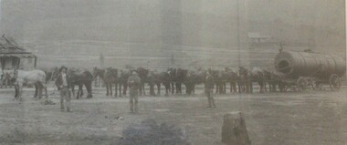
Bethanga was established as a result of the discovery of gold. Gold was first reported in the Bethanga area in 1852. Before 1876 gold mining in the Bethanga district occurred to the north of the town and was known as the 'Talgarno diggings'. Reports of alluvial gold date back to 1852. Early gold fields were worked at Ruby Creek, Gold Creek and Jarvis Creek. The opening of the Bethanga goldfields began with the discovery of a gold-bearing quartz reef on New Year’s Day 1876. The 'Gift' mine site is located southeast of Kurrajong Gap lookout to the west of Bethanga township. The Great Eastern Copper Smelting Works was opened in 1878. Due to the nature of the gold-bearing quartz reef, the gold was difficult to extract, and the discovery of copper led to a change in focus. It was not until the early 1890s that an efficient technique for extracting the gold from the ore was discovered, and once again gold became the focus, with copper as a by-product. Bethanga was removed from the official list of goldfields in 1912, however some mining activity has taken place since.This image reflects an important time in the development of Bethanga and Northeast Victoria.A large mounted and framed image of horse teams and their owners hauling a large boiler to the gold mine near Bethanga, Victoria. On label beneath image: "North-eastern "Gold Days"/ Combined teams hauling a boiler to Bethanga Mines, 1900. Teamsters - Mr. G. Pearce, W. Chapple, G, Bannon." Donated by Ron Saunders and Barbara Cadman"bethanga, gold mining northeast victoria, gold mining bethanga, bethanga history -
 Greensborough Historical Society
Photograph - Photograph (Framed), Early miners at work, 1850s
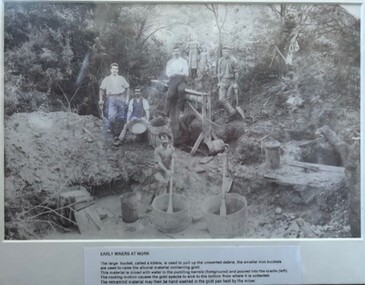
Early miners at work caption reads: "The large bucket, called kibble, is used to pull up the unwanted debris, the smaller iron buckets are used to raise the alluvial material containing gold. This material is mixed with water in the puddling barrells (foreground) and poured into the cradle (left). The rocking motion causes the gold specks to sink to the bottom from where it is collected. The remaining material may then be hand washed in the gold pan held by the miner." This photograph possibly taken at Diamond Creek.From the John Davidson collection.Photograph in black plastic frame with typed caption on matte.john davidson, diamond creek, gold miners, mines and mining -
 Federation University Historical Collection
Map - Map - Geological, Geological Survey of Victoria - Ballarat, 09/1858
Coloured Geological Map of Ballarat, edged with masking tape. The map show alluvial silt, gold drift, geological orders, volcanic, and gold workings. Scale is 8 chains to an inch. WGS 84 Centroid: 37 degrees 33 feet 33 inches south 143 degrees 52 feet 02 inches east W.E. extent: 5km NS extent: 3 kmballarat, ballaarat, geology, goldfield, phillips, j. phillips, mining, alfred selwyn, ferguson and mitchell -
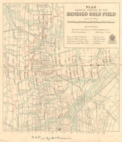 Bendigo Historical Society Inc.
Map - DEPARTMENT OF MINES VICTORIA : PLAN SHOWING PORTION OF THE BENDIGO GOLD FIELD
Department of Mines Victoria. Plan showing portion of the Bendigo Gold Field. On the back is written, in ink, J. J. Tyler 1937 Northern Area. (He was a teacher at Bendigo High - see donation notes). Across the bottom of the map is written ' M. Hill cr. Myrtle & Barnard' .The named reef lines have been numbered with ink across the bottom of the map. The gullies have been coloured with green pencil and a red pencil line is drawn through the western side of the map. Additional information: anticlinal axial lines at surface, alluvial workings, shaft sites, area of Main Goldfield, Deepest mine workings, Gold output of field to 1935, and Dividends paid 1870 - 1935.bendigo, gold mining, bendigo gold field. gold mining. tyler, j. j. -
 Eltham District Historical Society Inc
Photograph - Digital Photograph, Marguerite Marshall, One Tree Hill Mine, Smiths Gully, 8 June 2006
Gold was discovered on One Tree Hill in 1854. The site has been worked intermittently until fairly recent times. Published: Nillumbik Now and Then / Marguerite Marshall 2008; photographs Alan King with Marguerite Marshall.; p53 Though still a working mine, One Tree Hill Mine at Smiths Gully, now stands in a tranquil reserve surrounded by bush and native animals - in contrast to its heyday. In the mid 19th century, when the mine was part of the Caledonia Goldfields, hundreds of men in search of their fortune worked the alluvial gold in the Yarra River, its tributaries and the reefs that made up the goldfields. Miner Stan Bone, assisted by Wilfred Haywood, is the last of the independent gold miners in the area and still uses the quartz crushing battery as miners did when gold was first discovered in the area in 1851.1 Stan, who is the last of six generations of miners in his family, was aged 17 when he began mining on his father Alex’ mine, The Golden Crown in Yarrambat. These days, after blasting the gold-bearing rock in Mystery Reef, one of the four reefs at One Tree Hill, Stan transports it around five kilometres by tip truck to the Black Cameron Mine for crushing. There he uses water from the waterlogged mine, (which still contains gold), as the Happy Valley Creek at One Tree Hill is usually dry.2 The One Tree Hill Mine has been worked for close to a century since it opened around the late 1850s.3 The Swedish Reef was its most productive reef and one of the largest in the area. Around 1859, extractions included 204 ounces (5.8kg) of gold, won from 57 pounds (26kg) of stone.4 Then during World War Two, Stan’s uncle, Bill Wallace, and Alex Bone, closed the mine. In 1973, Stan, with his Uncle Bill, reopened the Black Cameron Mine and worked there until 1988. Stan resumed mining One Tree Hill in 1998. As late as the 1920s gold was picked up by chance! When crossing a gully on his way to vote at the St Andrews Primary School, Bill Joyce picked up some quartz containing gold. This site was to become the Black Cameron Mine. The Caledonia Diggings, named after Scotland’s ancient name by local Scots, began around Market Square (now Smiths Gully) and included Queenstown (St Andrews), Kingstown (Panton Hill) and Diamond Creek. There were also poorer bearing fields in Kangaroo Ground and Swipers Gully (now Research). * None of these compared in riches to the Ballarat and Bendigo fields5, but the Caledonia Diggings continued intermittently for close to 100 years. Gold was discovered in Victoria following a bid to stem the disappearance of much needed workmen to the New South Wales diggings. Several businessmen offered a reward of £200, for the discovery of gold within 200 miles (322 km) of Melbourne. Late in June 1851, gold was first discovered at Andersons Creek, Warrandyte. Then in 1854, George Boston and two other men discovered gold at Smiths Gully. Gold transformed the quiet districts, with a constant flow of families and vehicles on the dirt tracks en route to the Caledonia Diggings. Three thousand people worked the gullies in Market Square, including about 1000 Chinese miners. The square established its own police, mining warden, gold battery, school, shops and cemetery and grog flowed. Market Square flourished until the middle 1860s. Bullocks transported quartz from the Caledonia Goldfields to the crushing machinery at the Queenstown/St Andrews Battery, near Smiths Gully Cemetery. It was destroyed by bushfire in 1962. By the late 1850s, most early alluvial fields were in decline, but minor rushes continued until around 1900 and some until the early 1940s. Some miners did well, although most earned little from their hard labour in the harsh and primitive conditions.6 But according to historian, Mick Woiwod, the gold fields helped to democratise society, as individuals from all walks of life were forced to share experiences, and the ability to succeed, depended less on inherited wealth or social rank.This collection of almost 130 photos about places and people within the Shire of Nillumbik, an urban and rural municipality in Melbourne's north, contributes to an understanding of the history of the Shire. Published in 2008 immediately prior to the Black Saturday bushfires of February 7, 2009, it documents sites that were impacted, and in some cases destroyed by the fires. It includes photographs taken especially for the publication, creating a unique time capsule representing the Shire in the early 21st century. It remains the most recent comprehenesive publication devoted to the Shire's history connecting local residents to the past. nillumbik now and then (marshall-king) collection, gold mining, one tree hill mine, smiths gully -
Bendigo Historical Society Inc.
Map - GEOLOGICAL MAP OF BENDIGO GOLD FIELD
Map of Bendigo gold field showing anticlines, synclines, shaft, alluvial deposits and contour lines. Map is in two sections. This map forms part of the Geological Survey of Victoria, Structure of Bendigo Goldfield report, No. 47, 1923. H.Herman, late Director of Geological Survey.Geological Survey Victoriabendigo, gold mining, geological map -
 Bendigo Historical Society Inc.
Document - STRAUCH COLLECTION: DEPT OF MINES,REPORT ON HUNTLY ALLUVIAL LEAD
... BHS Collection MINING Extraction alluvial 1898 Victoria ...BHS Collection1898 Victoria Department of Mines report on the Huntly Alluvial Lead with assorted maps.mining, extraction, alluvial -
Bendigo Historical Society Inc.
Document - Return of Gold Mines 1859, 1876
Four page photocopy document 'Legislative Assembly 1859, Return of gold mine leases'. Information detailed includes: lessee; name of company; gold field; mining district; description of lease (alluvial/quartz) area; term; annual rent; capital, machinery value; minimum number of men to be employed. Example: Union Co., Sheepshead Gully, quartz mine, area 3 roods, and 22 perches, term 10 years, amount of rent 4 pounds 8 shillings and ninepence, capital 4,000 pounds, machinery 3,000 pounds, minimum amount of men to be employed - 2. Names of mine lessees: W. Tongue, R. Lysle, G. Nevison, T. Porter, J. Griston. mining, sandhurst, mining leases, labour convenant, union co., sheepshead gully, quartz mine, legislative assembly, return of gold mines, -
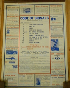 Bendigo Historical Society Inc.
Document - MARKS COLLECTION: CODE OF SIGNALS FOR MINES CHART
Poster, printed on coated fabric, wooden hanger on top. Yellow background, printed in red and blue. 'Code of Signals, Section 45 (19) of the Mines Act 1961. lode and alluvial mines, signals for winding' Signals: 1 stop when in motion, 1 heave up, 2 lower, 3 hold fast danger, 4 pause men coming to surface, 6 cage at liberty, 7 change tanks or cages, 8 put drum in or out of gear, 9 turn air on or off, 10 accident, 15 serious accident. Also lists firing signals. Advertisements for suppliers to mining companies around border of poster. E.g. Jaques Bros., Engineers, Coppin Street, Richmond, Melbourne. Ore and Stone Breakers manufactured in various sizes (has illustration of machine). James Hardie & Co., 581 Little Collins Street, Melbourne. Necessaries for success in mining enterprises are: Dick's original balata belting to drive your machinery with; Genuine Dodge wood split pulleys on the shafting, and fibro ciment(sic) sheets to protect you from fire. These sheets are also acid-proof.bendigo, mining, code of signals -
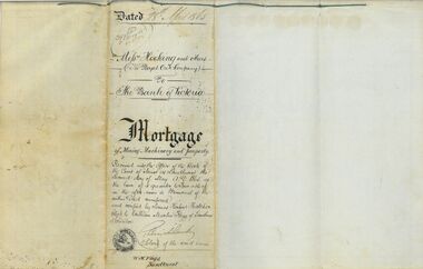 Bendigo Historical Society Inc.
Legal record - Hartnell Legal Documents: Hocking Mortgage of Mining Machinery and property 1865
Document dated 28th April 1865 "All that the amalgamated alluvial claim at Pottery Flat aforesaid registered Number 881 in the Books of the Mining Register for the Mining District of Sandhurst known as the Royal Oak Company's claim." Listed in "The Bendigo goldfield registry" 1872 as Royal Oak Company: Bignell's Reef, Derwent Gully. Capital £24000., in £24,000 20s. shares. Manager, W. Barker. Newspaper articles dating from 11 Jan 1867 refer to the company as "Royal Oak Mining Company". Both names appear to be used interchangeably. This A3 document is made up of 3 pieces of heavy stock lined paper. The document is bound on the left side with glue and string creating a book which comprises the legal contract of mortgage for mining equipment. The document is handwritten in black ink across 4 pages (2 double sided pages) with the last page acting as the documents cover when folded down into a pamphlet. The signature page includes 9 red wax seals. When held up to the light, the cover page and internal page show an indentation reading G. Wilmot 1862. The first page of the contract shows an indentation of a crest and the initials GW.joseph hocking, alfred inkson gillman, benjamin lean, absalom brewer, donald fraser, william seed, john rowe, william collier, george drake, mining, royal oak company, the bank of victoria, g. wilmot -
 Bendigo Historical Society Inc.
Document - VICTORIA HILL - THE BENDIGO DIGGINGS, PRELIMINARY DRAFT FOR BROCHURE
BHS CollectionNine typed pages of notes on a preliminary draft for a brochure on the Bendigo Diggings. First part is the objective which is to preserve the mining history and to have exhibits in the places they were used, e.g. quartz mining machinery exhibited in a quartz mining area, not on an alluvial field. Part B is historical notes on the area. Part C is the Site - Victoria Hill area. Part D is Stage One which consists of carpark area, technological museum, restaurant, mineral haulage line, picnic ground, earthworks and planting over the area. Part E is Stage Two which will consist of the open-air exhibits, in the area surrounded by the mineral haulage line, and the Central Nell Gwynne mine on the west side of the site. Part F is Stage Three which will consist of the winery, the steam tram track, the lake, the wildlife sanctuary and various buildings associated with gold mining. Part G is Costing with the prices to be filled in. Parts H and I are the Appeal and the Committee. Details to be filled in. Notes prepared by Albert Richardson.mining, marketing, victoria hill, victoria hill, the bendigo diggings - preliminary draft for brochure, aust national travel association, tullamarine jetport, emu bottom homestead, kyneton historical museum, chinese joss house, eaglehawk museum, whipstick scrub, cairn curran reservoir, castelmaine historical museum and market hall, national trust, ballarat hiatorical park, echuca's hopwood gardens, swan hill folk museum, gibson's mount alexander no 2 squatting run, captain brown, chief commissioner wright, hustler's reef, thomas hustler, mining board, drainage of reefs act 1862, first world war, bendigo amalgamated goldfields, second world war, sandhurst, w c vahland, battery trams, horse trams, steam trams, electric trams, central nell gwynne mine, theodore ballerstadt, george lansell, new chum hill, ballerstadt's open cut, 180 mine, new chum syncline battery, william rae, victoria quartz, wittscheibe's 'jeweller's shop', luffsman and sterry, gold mines hotel, adventure, bendigo and district tourist association, bendigo city council, bendigo branch of the royal historical society of victoria, professor brian lewis, school of architecture and building at the university of melbourne, taylor horsfield, lord robert cecil, south australian gold commissioner -
 Bendigo Historical Society Inc.
Document - GARDEN GULLY LINE OF REEF, LEASE BLOCKS 5360 AND 5361
Two page document titled ' Report on lease blocks Nos. 5360 and 5361 Garden Gully line of reef, Bendigo. Produced by the Department of Mines 1899. The area described is about 'one mile and a quarter southeast from the centre of the city of Bendigo, immediately south of the Great Southern Gold Mining Company's workings and is intersected by two auriferous gullies ... Salomon's Gully and Derwenter's Gully'. The alluvial deposits, the Garden Gully line, the Great Souther Co.and old workings are discussed in the paper. A map of the Garden Gully line of reef is attached to the report, showing claimholders and mine names along that section of the reef. Mines named on the map: Great Southern Garden Gully United Ulster Londonderry Burrows Horwoods Sea Amalgamated Garden Gully United Victory and Pandora Unity Carlisle and Garden Gully and Passbye United Cornish United Koch's PioneerJames Stirling, Government Geologistbendigo, mining, garden gully line of reef mines -
 Bendigo Historical Society Inc.
Document - AUCTION SALES - MINING CATALOGUE AUCTION SALES
BHS CollectionYellow and white patterned, spring back Spirax Students No. 594 Note Book containing extracts from mining Catalogues loaned by Mr. Dyett (J. H. Curnow's). Mines mentioned include Ramrod Gold Mine, Hercules No. 1, Central Blue, South Virginia Extended, Alfords Battery, South New Moon,The Gold Mine Clunes, Guildford Plateau, Big Blue, Spring Gully Mine at Chewton, Eureka Central at Chewton, Bdgo Amalg. Goldfields Limited, Koch's Air Station, Cornish Mine, Carlisle Battery, Victory & Pandora Mine, Garden Gully, Londonderry Mine, Princess Dagmar, Golden Age, Suffolk United, Virginia South Extended, South Red White & Blue, Pitfield Plains Glenfine South Shaft, Adelong Dredge & Leases, Bright Valley Dredge, North Chewton (Chewton), Talbot Alluvials Norbury's No. 2 Shaft, Gordon Gold Mine Inglewood, Post Office Hill Mine Chewton, Carlisle & Whittaker Plant Maldon, Bunninyong, Yandoit Mine, North Chewton, Golden Transverse Bdgo, Yandoit Co., Chapman's Gold Mine Chewton, Ross Creek Extended G. M. Coy (Ballarat).book, bendigo, mining auction sales, auction sales mining catalogue auction sales, j h curnow, mr dyett, a richardson, ramrod gold mine, hercules no. 1, central blue, south virginia extended, alfords battery, south new moon, the gold mine clunes, guildford plateau, big blue, spring gully mine at chewton, eureka central at chewton, bdgo amalg. goldfields limited, koch's air station, cornish mine, carlisle battery, victory & pandora mine, garden gully, londonderry mine, princess dagmar, golden age, suffolk united, virginia south extended, south red white & blue, pitfield plains glenfine south shaft, adelong dredge & leases, bright valley dredge, north chewton (chewton), talbot alluvials norbury's no. 2 shaft, gordon gold mine inglewood, post office hill mine chewton, carlisle & whittaker plant maldon, bunninyong, yandoit mine, north chewton, golden transverse bdgo, yandoit co., chapman's gold mine chewton, ross creek extended g. m. coy (ballarat). -
 Bendigo Historical Society Inc.
Document - DIAMOND HILL HISTORIC AREA PARKS VICTORIA
Document, two pages, prepared by Parks Victoria in relation to the Diamond Hill Historic Area. Contains information regarding the history of the area; German Miners; Plants and animals. On second page is a map of the area showing historic features: Deborah Consolidated Gold workings Red, White and Blue Extended gold workings Goldfields Extended gold workings Dead Dog Gully, alluvial gold workings Glasgow & Golconda Gold workings and tramway Surface gold mining site Hansel Mundy gold workings Bendigo Goldfields Pty gold workings Stafford gold workings Langdon gold workings Great Opossum Gully alluvial gold workingsbendigo, mining, diamond hill -
 Bendigo Historical Society Inc.
Document - MINING IN BENDIGO COLLECTION: MINING ARTICLE FROM THE SCHOOL PAPER
Printed article from The School Paper dated July 1, 1952. The article was written for The School Paper by Lucy Hill. Mentioned in the article are the licence tax, which preceded the Miners Right, the building of slab huts, a nugget of gold weighing 340 ounces and christened The Victoria which was later presented to Queen Victoria, how alluvial gold came into being, notes about the Needle Mine's square shaped chimney with the smoke holes in its tapering top and the progress which has occurred in Bendigo both cultural and in the buildings.document, gold, mining in bendigo, mining in bendigo, mining article from the school paper, lucy hill, miners right, queen victoria, marco polo sailing ship, bendigo goldfield, the needle mine, loddon regional, bendigo advertiser, easter fair, chinese dragon, teachers' training college, competitions society, shakespeare society, agricultural society and show -
 Bendigo Historical Society Inc.
Document - MINING REPORTS - ANNUAL REPORT, INCLUDING GOLD & MINERAL STATISTICS 1936
Handwritten notes from the Annual Report, including Gold & Mineral Statistics, 1936. Mentioned are the London price of gold and the equivalent local price, No of batteries, Abandoned Mining Shafts, Cost of making the shafts safe, Inspection of boilers and the no condemned, No of First and Second Class e 'driver Certificates issued for 1935 and 1936, Alluvial and quartz gold yields for the Bendigo District, men employed in mining, Accidents and development at the Central Nell Gwynne.document, gold, mining reports, annual report including gold & mineral statistics 1936, state batteries, central nell gwynne -
 Bendigo Historical Society Inc.
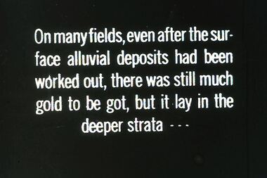
Slide - DIGGERS & MINING. DIGGERS AND MINERS, c1850s
BHS CollectionDiggers & Mining. Diggers and miners. On many fields, even the surface alluvial deposits had been worked out, there was still much gold to be got, but it lay in the deeper strata - - - Markings: 21 994:LIF I. Used as a teaching aid.hanimounteducation, tertiary, goldfields -
 Bendigo Historical Society Inc.
Document - NEW CHUM & VICTORIA LINES OF REEF - NOTES ON THE VICTORIA REEF GOLD MINES COY
Handwritten notes describing the journey along Eaglehawk Road from the houses, poppet heads and mine tailings, etc. When the alluvial diggings were showing signs of exhaustion, and the fear arose that Bendigo was 'about done', two 'darkies' One named Dido, struck golden stone. They sold out to Ballerstedt and Son, and thus gold mining was revived. These areas were remarkable for the extraordinary richness of the lodes, and the singular manner in which the gold is distributed.document, gold, new chum & victoria lines of reef, notes on the victoria reef gold mines coy, gavan duffy, victoria hill, black lead, prince alfred, ballerstadt & son, goldfields registry, mr macartney, wittscheibe, luffsman -
 Bendigo Historical Society Inc.
Document - MINING REPORTS - YIELDS FROM ALLUVIAL & QUARTZ REEFS 1897
... MINING REPORTS - YIELDS FROM ALLUVIAL & QUARTZ REEFS 1897...DOCUMENT Gold Mining Reports Yields from Alluvial & Quartz ...Handwritten notes give details of alluvial, and quartz yields from the Sandhurst and Eaglehawk gold fields. Ref. Sec. Mines Report 1897, Page 13. Also, a report from the Sec. Mines Report1905 Pages 116 & 117 mentioning the number of men employed at Kochs Pioneer, Confidence Ex'td, North Johnsons and Princess Dagmar Mines. Report by G Hawke, Acting Inspector of Mines E'Hawk No 10 Dist.document, gold, mining reports, yields from alluvial & quartz reefs 1897, sandhurst gold field, g hawke, kochs pioneer, confidence ex'td, north johnsons, princess dagmar -
 The Beechworth Burke Museum
Photograph
This image is a reproduction of an 1899 original depicting the 'Williams Good Luck Mine' on the Mopoke Reef (also called 'Morepork Gully') in the Dingle Ranges, approximately three miles from Beechworth. A large opening to a mine can be seen behind the men in the photograph, with a wheeled cart on a track leading to the men's position, where the soil and rocks have been hauled away. This photograph interestingly contains dogs alongside the miners. While dogs have been recorded as deterrents to thieves in the Victorian goldfields, these dogs appear as companions to these men. Following the discovery of gold at Beechworth in 1852, rushes quickly followed at surrounding creeks and gullies in the district. In the late nineteenth and early twentieth centuries, small syndicates of miners continued to work old or abandoned quartz reefs, often persisting without the assistance of heavy machinery to remove the large amounts of rock, in order to obtain yields at ever greater depths. The group of miners in this photograph are Mr. Roger Williams and Sons, who revived operations at the ‘Old Good Luck’ mine on the Mopoke Reef in the Dingle Range near Beechworth around 1892, working the site for more than two decades. An emigrant from Cornwall with experience in the tin mining industry, 19 year old Roger Williams senior sailed to New Zealand in 1840, then to Australia where he spent time in the Bendigo Gold Fields before settling in Beechworth in the early 1860s. Mr Williams senior worked on various mining activities in the district, including the Rocky Mountain Tunnel project. Conversant with the character of gold-bearing reefs in the area, the syndicate dug an eight hundred foot tunnel, digging down as far down as two hundred feet with little capital save their labour, to connect and provide better working access to the mass of reefs and veins in the vicinity. Progress was hampered by poor air quality charged with fumes from dynamite and large quantities of rock had to be crushed to obtain payable yields. The Victorian Goldfields are filled with ruins and remnants of the area's rich mining history, ranging from small alluvial diggings to the remains of huge mining companies. Site names often changed several times throughout the nineteenth and twentieth centuries. Some sites were abandoned and forgotten, others were worked continuously over many decades. The names of mines were often repeated at different locations throughout the Victorian Goldfields. For example, there is a Mopoke Gully heritage mine near Fryers Creek, Victoria. 'Mopoke' is a common onomatopoeic name for Morepork and Australian Boobook owls.This image has historical, social and research significance for patterns of emigration during of the Victorian Gold Rush, and the historical, social and environmental impacts of mining at Beechworth at the turn of the nineteenth and twentieth centuries. As gold became scarce and government support and large company investment waned, poor hard-working miners laboured intensively to make a living through periods of high unemployment. This image can be compared and studied alongside other historical mining photographs and objects in the Burke Museum Collection. It has potential to improve our understanding of miners working conditions and the shifting character of mining in the Beechworth district.Sepia coloured rectangular photograph printed on gloss photographic paper mounted on card. Obverse: Williams/ Good/ Luck Reverse: A02498/ 1997. 2498/ Good Luck/ Mine/ 1899/ Mopoke. burke museum, beechworth museum, beechworth, gold fields, gold rush, victorian gold rush, gold ming history, colonial australia, australian gold rushes, mining technology, beechworth historic district, indigo gold trail, migration, indigo shire, good luck gold mine, victorian goldfields, mining syndicates, gold fever, quartz-mining, small-scale mining, old good luck mine, mopoke gully, quartz reefs beechworth -
 The Beechworth Burke Museum
Photograph
This image is a reproduction of an 1899 original depicting the 'Williams Good Luck Mine' on the Mopoke Reef (also called 'Morepork Gully') in the Dingle Ranges, approximately three miles from Beechworth. The foreground of the image is littered with piles of smashed rock and detritus, known as ‘mullock’, beside a reinforced mine shaft, a vertical access passageway allowing miners to enter the mine and haul ore out using lifting technology such as a poppet heads, whims or windlasses. A group of miners and a dog appear close to an open-sided miner’s hut. Following the discovery of gold at Beechworth in 1852, rushes quickly followed at surrounding creeks and gullies in the district. In the late nineteenth and early twentieth centuries, small syndicates of miners continued to work old or abandoned quartz reefs, often persisting without the assistance of heavy machinery to remove the large amounts of rock, in order to obtain yields at ever greater depths. The group of miners in this photograph are Mr. Roger Williams and Sons, who revived operations at the ‘Old Good Luck’ mine on the Mopoke Reef in the Dingle Range near Beechworth around 1892, working the site for more than two decades. An emigrant from Cornwall with experience in the tin mining industry, 19 year old Roger Williams senior sailed to New Zealand in 1840, then to Australia where he spent time in the Bendigo Gold Fields before settling in Beechworth in the early 1860s. Mr Williams senior worked on various mining activities in the district, including the Rocky Mountain Tunnel project. Conversant with the character of gold-bearing reefs in the area, the syndicate dug an eight hundred foot tunnel, digging down as far down as two hundred feet with little capital save their labour, to connect and provide better working access to the mass of reefs and veins in the vicinity. Progress was hampered by poor air quality charged with fumes from dynamite and large quantities of rock had to be crushed to obtain payable yields. The Victorian Goldfields are filled with ruins and remnants of the area's rich mining history, ranging from small alluvial diggings to the remains of huge mining companies. Site names often changed several times throughout the nineteenth and twentieth centuries. Some sites were abandoned and forgotten, others were worked continuously over many decades. The names of mines were often repeated at different locations throughout the Victorian Goldfields. For example, there is a Mopoke Gully heritage mine near Fryers Creek, Victoria. 'Mopoke' is a common onomatopoeic name for Morepork and Australian Boobook owls.This image has historical, social and research significance for patterns of emigration during of the Victorian Gold Rush, and the historical, social and environmental impacts of mining at Beechworth at the turn of the nineteenth and twentieth centuries. As gold became scarce and government support and large company investment waned, poor hard-working miners laboured intensively to make a living through periods of high unemployment. This image can be compared and studied alongside other historical mining photographs and objects in the Burke Museum Collection. It has potential to improve our understanding of miners working conditions and the shifting character of mining in the Beechworth district.Sepia coloured rectangular photograph printed on gloss photographic paper mounted on card.Obverse: Reverse: A02497/ 1997.2497/ 'Good/ Luck/ Mine'/ Morepork/ Gully/ Mrs Joyce/ Bright/ Tunnel/ 800 ft/ 1899. burke museum, beechworth museum, beechworth, gold fields, gold rush, victorian gold rush, gold ming history, colonial australia, australian gold rushes, mining technology, beechworth historic district, indigo gold trail, migration, indigo shire, good luck gold mine, victorian goldfields, mining syndicates, gold fever, quartz-mining, small-scale mining, old good luck mine, mopoke gully, quartz reefs beechworth -
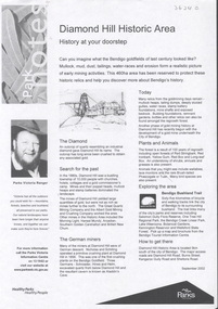
Clunes Museum
Map, DEPARTMENT OF MINES, Untitled, c1859
All maps show names and locations of mines operating in the district (see reference section link to article).1 Map of Creswick Clunes - lists 45 mines in the Clunes enlargement and 100 mines in the Creswick enlargement .2 Department of Mines map of Clunes Creswick and shows the McDonald & Co. Pre-emptive area. Indexes for quartz and alluvial mine locations .3 Topographical map Ref GF23 Clunes Mt. Greenock Talbot.1 360 Scale 1:2500 .2 303/59 33 hand written in ink "received 15 October 1859" signed by R Broughton, James Stevenson - District Mining Surveyor .3 40 chains to an Inchgold mining, dept of mines