Showing 299 items
matching aqueducts
-
 Bendigo Historical Society Inc.
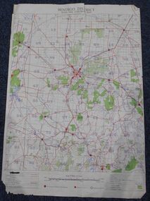
Map - MARONG : COUNTY OF BENDIGO, June 1953
Map. Marong, County of Bendigo, Nerring, Sandhurst, Lockwood, Shelbourne, Woodstock, Leichardt, Fletcher Creek, Bullock Creek, Township of Marong, Marong Railway Station, Bendigo Railway Line, Spring Creek, Crusoe Aqueduct. By authority W.M. Houston, Government Printer. Drawn and reproduced at the Department of Lands and Survey, Melbourne, Victoria. June 1953. Price 2/-. (number 73 in map cupboard 1)W.M. Houston, Government Printermap, bendigo, marong -
 Eltham District Historical Society Inc
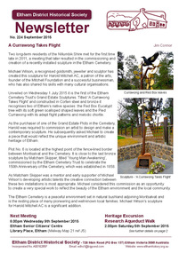
Journal - Newsletter, Newsletter, No. 264 June 2022, Jun 2022
Contents: • Fifty Five Years Ago • Our Next Meeting – 2.00pm Saturday 11th June 2022 • Heritage Excursion – Saturday 2nd July - Eltham Lower Park – Walk and Talk • Those Wild Aqueduct Days • How the Wheel Turns . . . Sometimes by Jim Connor • Eltham Progressing – 1925 • Unusual Requests? By Jim Connor • Drownings in the Aqueduct by Richard Pinn • Register of Significant Trees by Jim Connor • Eltham Cemetery Stories by Liz Pidgeon o Memorial to Stillborn Babies • Annual General Meeting –Saturday 23rd April 2022 • SubscriptionsThe Shire of Eltham Historical Society was formed in October 1967. The first newsletter of the Society was issued May 1978 and has been published continuously ever since on a bi-monthly basis. With the cessation of the Shire of Eltham in late 1994, the Society's name was revised to Eltham District Historical Society and this name first appeared with issue No. 103, July 1995. The collection of the Society's newsletters provides a valuable resource on the history of the Society's activities, office bearers and committee members, guest speakers and subjects of historical interest pertinent to the former Shire of Eltham and the Eltham District.A4 newsletter distributed to members (Digital and A4 photocopy)newsletter, eltham district historical society -
 Bendigo Historical Society Inc.
Map - Bush Fire Control Map Bendigo District
A Bush Fire Control map is a valuable tool used by emergency services and communities to respond to respond to bushfires.Cream coloured parchment map showing roads, railway lines, telephone lines, rivers, creeks and water courses. Also marked are houses, Post Offices, Police stations, bush fire brigades, water channels, swamps, marshes, dense, medium and scattered timber, aqueducts and reservoirs. Villages, districts and Towns are clearly marked. Printed in red, green, black and blue. Very clear and easy to read. Undated.bush fires, bendigo area map -
![Photograph - Digital image, Pioneer Children's Graves [graves and aqueduct], 1985_](/media/collectors/4f729f5697f83e03086015b8/items/54bb57442162f10ca8d7a0b6/item-media/54bb57762162f10ca8d7a408/item-fit-380x285.jpg) Greensborough Historical Society
Greensborough Historical SocietyPhotograph - Digital image, Pioneer Children's Graves [graves and aqueduct], 1985_
The unmarked graves of the children of two Greensborough pioneer families lie in a private cemetery on the Plenty River. Burials occurred between 1848 and 1860. This photograph shows the cemetery site with jonquils in bloom and the Maroondah Aqueduct in the background. An important historical site in Greensborough.Digital copy of colour photograph.pioneer childrens cemetery, maroondah aqueduct, whatmough, partington -
 Eltham District Historical Society Inc
Newsletter, No. 25 July 1982
Contents: • Next meeting – Examination and collation of historical photographs • Former Falkiner Cottage • Other Council matters o Former Lands Department building o Development of Council Pound site o Maroondah Aqueduct The Shire of Eltham Historical Society was formed in October 1967. The first newsletter of the Society was issued May 1978 and has been published continuously ever since on a bi-monthly basis. With the cessation of the Shire of Eltham in late 1994, the Society's name was revised to Eltham District Historical Society and this name first appeared with issue No. 103, July 1995. The collection of the Society's newsletters provides a valuable resource on the history of the Society's activities, office bearers and committee members, guest speakers and subjects of historical interest pertinent to the former Shire of Eltham and the Eltham District.A4 photocopied newsletter distributed to membersnewsletter, eltham district historical society, shire of eltham historical society -
 Eltham District Historical Society Inc
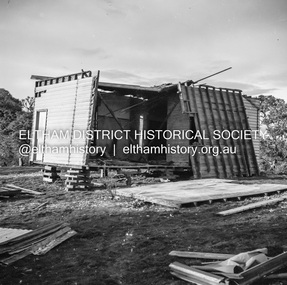
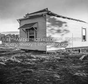
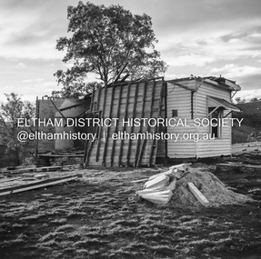
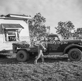
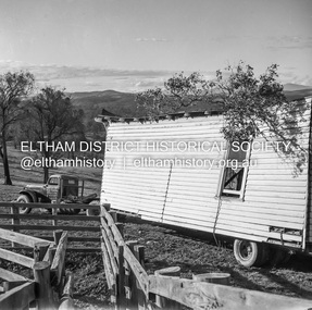
Negative - Photograph, J.A. McDonald, Inspection of storm damaged Abraham house at Kangaroo Ground, c. May 1962
Showing the effect of a wind storm that destroyed the house circa May 1962.. The Abraham family owned land near the Aqueduct and east of Nicholas Lane at Kangaroo Ground (based on photos, at or near 40 Nicholas Lane).Record of various Shire of Eltham infrastructure works undertaken during the period of 1952-1962 involving bridge and road reconstruction projects, sometimes with Eltham Shire Council Project Reference numbers quoted. It was during this period that a number of significant improvements were made to roads and new bridges constructed within the shire that remain in place as of present day (2022). In many situations, the photos provide a tangible visible record of infrastructure that existed throughout the early days of the Shire. The album was put together by or under the direction of the Shire Engineer, J.A. McDonald.1962-05, abraham house, kangaroo ground, nicholas lane, property damage, storm damage -
 Eltham District Historical Society Inc
Negative - Photograph, J.A. McDonald, Inspection of storm damaged Abraham house at Kangaroo Ground, c. May 1962
Showing the effect of a wind storm that destroyed the house circa May 1962.. The Abraham family owned land near the Aqueduct and east of Nicholas Lane at Kangaroo Ground (based on photos, at or near 40 Nicholas Lane).Record of various Shire of Eltham infrastructure works undertaken during the period of 1952-1962 involving bridge and road reconstruction projects, sometimes with Eltham Shire Council Project Reference numbers quoted. It was during this period that a number of significant improvements were made to roads and new bridges constructed within the shire that remain in place as of present day (2022). In many situations, the photos provide a tangible visible record of infrastructure that existed throughout the early days of the Shire. The album was put together by or under the direction of the Shire Engineer, J.A. McDonald.1962-05, abraham house, kangaroo ground, nicholas lane, property damage, storm damage, building surveyor, george e. newton -
 Eltham District Historical Society Inc
Negative - Photograph, J.A. McDonald, Inspection of storm damaged Abraham house at Kangaroo Ground, c. May 1962
Showing the effect of a wind storm that destroyed the house circa May 1962.. The Abraham family owned land near the Aqueduct and east of Nicholas Lane at Kangaroo Ground (based on photos, at or near 40 Nicholas Lane).Record of various Shire of Eltham infrastructure works undertaken during the period of 1952-1962 involving bridge and road reconstruction projects, sometimes with Eltham Shire Council Project Reference numbers quoted. It was during this period that a number of significant improvements were made to roads and new bridges constructed within the shire that remain in place as of present day (2022). In many situations, the photos provide a tangible visible record of infrastructure that existed throughout the early days of the Shire. The album was put together by or under the direction of the Shire Engineer, J.A. McDonald.1962-05, abraham house, kangaroo ground, nicholas lane, property damage, storm damage -
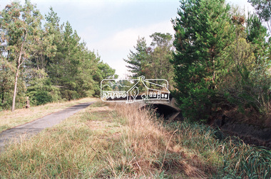 Eltham District Historical Society Inc
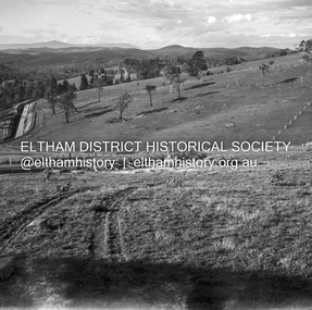
Negative - Photograph, Maroondah Aqueduct Trail near The Esplanade, Research, 1991
Looking northwest along the Maroondah Aqueduct Trail towards The Esplanade near Main Road, Research, 1991. Just after first bend from Main Road. To the left is present day (2022) Mickey's FitnessRoll of 35mm colour negative film, 9 strips Colour print 10 x 15 cmFuji HG 200 CA-1bridge, ingrams road, maroondah aqueduct, maroondah aqueduct trail, research (vic.), the esplanade -
 Eltham District Historical Society Inc
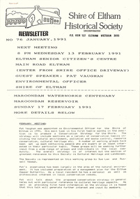
Newsletter, No. 76 January 1991
Contents: • Next meeting, guest speaker; Pat Vaughan, Environmental Officer, Shire of Eltham • February Meeting • Maroondah Aqueduct Centenary • Annual General Meeting • Eltham, England • ‘Watershed’ Jackson • Kangaroo Ground Fire Brigade • Other News The Shire of Eltham Historical Society was formed in October 1967. The first newsletter of the Society was issued May 1978 and has been published continuously ever since on a bi-monthly basis. With the cessation of the Shire of Eltham in late 1994, the Society's name was revised to Eltham District Historical Society and this name first appeared with issue No. 103, July 1995. The collection of the Society's newsletters provides a valuable resource on the history of the Society's activities, office bearers and committee members, guest speakers and subjects of historical interest pertinent to the former Shire of Eltham and the Eltham District.A4 photocopied newsletter distributed to membersnewsletter, eltham district historical society, shire of eltham historical society -
![Photograph - Digital image, Pioneer Children's Cemetery [from above], 1985_](/media/collectors/4f729f5697f83e03086015b8/items/54bb56202162f10ca8d79013/item-media/54bb56452162f10ca8d79127/item-fit-380x285.jpg) Greensborough Historical Society
Greensborough Historical SocietyPhotograph - Digital image, Pioneer Children's Cemetery [from above], 1985_
The unmarked graves of the children of two Greensborough pioneer families lie in a private cemetery on the Plenty River. Burials occurred between 1848 and 1860. This photograph is taken from above the cemetery site looking towards the Plenty River with the Maroondah Aqueduct in the background.An important historical site in Greensborough.Digital copy of colour photograph.pioneer childrens cemetery, plenty river, maroondah aqueduct, partington, whatmough -
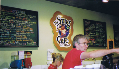 Greensborough Historical Society
Photograph - Digital image, Frank Solomon, The Snug Cafe St Helena 1, 1990c
St Helena Marketplace was the site of "The Snug". These photographs were taken by Frank Solomon and depict a cafe called The Snug, which is no longer operating. [Location information: Shop 10 St Helena Market Place Aqueduct Road Diamond Creek Vic 3089] Digital copy of colour photographthe snug, st helena marketplace, st helena -
 Bendigo Historical Society Inc.
Photograph - Historical Society Field Trip to Coliban Water Assets, Dec 2009
The original Coliban Water Works were designed in 1863 by the Irish engineer Joseph Brady. The system included 70 kilometres of open water channels, aqueducts, syphons and tunnels to carry water (by gravity) from the Coliban River at Malmsbury, north to Castlemaine and Bendigo.One hundred and nineteen photos taken on a field trip by the Bendigo Historical Society to Coliban Water Supply assets.history, bendigo, coliban water, joseph brady, irrigation -
 Greensborough Historical Society
Article - Journal - Excerpt, Victorian Government Gazette, Melbourne water supply 1879, 25/04/1879
An historical account from the Victorian Government Gazette 25/04/1879: Contract accepted - Melbourne Water Supply - B. Barnes & Co. Masonry abutments and piers, also construction and erection of wrought iron aqueduct over Plenty River at Morang. 5250 pounds.History of the Maroondah aqueduct1 p., photocopy of article, downloaded from State Library of Victoriamelbourne water, mmbw, maroondah aqueduct, plenty river -
 Greensborough Historical Society
Article - Journal - Excerpt, Victorian Government Gazette, Melbourne water supply 1890, 15/08/1890
An historical account from the Victorian Government Gazette 15/08/1890: Contract accepted - Melbourne Water Supply - Mephan Ferguson. Manufacture and erection of wrought iron tubular aqueduct over Plenty River near Greensborough. Addition and extension to Watts River Scheme.History of the Maroondah aqueduct1 p., photocopy of article, downloaded from State Library of Victoriamelbourne water, mmbw, maroondah aqueduct, plenty river, watts river -
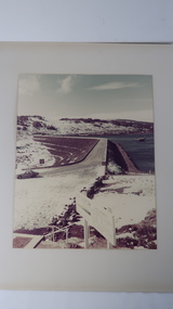 Kiewa Valley Historical Society
Photo - Rocky Valley Dam
The State Electricity Commission of Victoria constructed the Kiewa Hydro Electric Scheme on the Bogong High Plains. The scheme consisted of storage dams and pondages, aqueducts, tunnels, pipelines, transmission lines and three power stations.. Rocky Valley dam was the biggest storage and the last to be completed.Rocky Valley dam was the largest storage within the Kiewa Hydro Electric Scheme. Begun in 1954 and completed in 1960. It was linked to McKay Creek Power StationColoured photo attached to cream cardboard. The background shows hills and the foreground a sign "Rocky Valley Dam ..." The middle shows the dam with water and its bank. There is snow on the ground.rocky valley dam, kiewa hydro electric scheme, secv -
 Eltham District Historical Society Inc
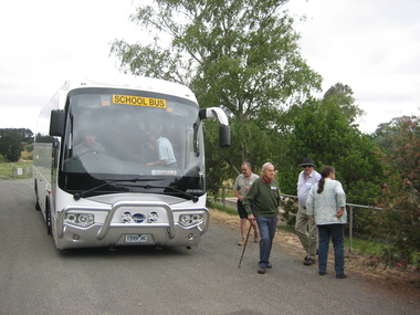
Newsletter, No. 224 September 2015
Contents: • A Currawong Takes Flight • September Meeting - Nillumbik Tales: Voices of our Elders • September Excursion - Research Aqueduct Walk • The Wackett Brothers by Jim Allen • Picnic at Wattle Glen by Richard Pinn • Murray's Land • ....and also • Contacts for the Eltham District Historical Society The Shire of Eltham Historical Society was formed in October 1967. The first newsletter of the Society was issued May 1978 and has been published continuously ever since on a bi-monthly basis. With the cessation of the Shire of Eltham in late 1994, the Society's name was revised to Eltham District Historical Society and this name first appeared with issue No. 103, July 1995. The collection of the Society's newsletters provides a valuable resource on the history of the Society's activities, office bearers and committee members, guest speakers and subjects of historical interest pertinent to the former Shire of Eltham and the Eltham District.A4 photocopied newsletter distributed to membersnewsletter, eltham district historical society, shire of eltham historical society -
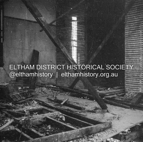
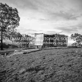
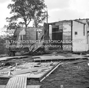
 Eltham District Historical Society Inc
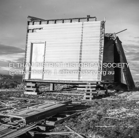
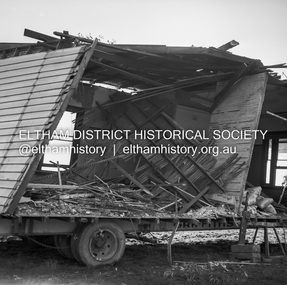
Negative - Photograph, J.A. McDonald, Removal of the remains of the Abraham house at Kangaroo Ground, c. May 1962
Martin Bros House Removing of Seaford was contracted to remove the remains of the storm damaged Abraham house from the property circa May 1962. The Abraham family owned land near the Aqueduct and east of Nicholas Lane at Kangaroo Ground (based on photos, at or near 40 Nicholas Lane).Record of various Shire of Eltham infrastructure works undertaken during the period of 1952-1962 involving bridge and road reconstruction projects, sometimes with Eltham Shire Council Project Reference numbers quoted. It was during this period that a number of significant improvements were made to roads and new bridges constructed within the shire that remain in place as of present day (2022). In many situations, the photos provide a tangible visible record of infrastructure that existed throughout the early days of the Shire. The album was put together by or under the direction of the Shire Engineer, J.A. McDonald.1962-05, abraham house, kangaroo ground, martin bros house removing seaford, nicholas lane, property damage -
 Eltham District Historical Society Inc
Negative - Photograph, J.A. McDonald, Removal of the remains of the Abraham house at Kangaroo Ground, c. May 1962
Martin Bros House Removing of Seaford was contracted to remove the remains of the storm damaged Abraham house from the property circa May 1962. The Abraham family owned land near the Aqueduct and east of Nicholas Lane at Kangaroo Ground (based on photos, at or near 40 Nicholas Lane).Record of various Shire of Eltham infrastructure works undertaken during the period of 1952-1962 involving bridge and road reconstruction projects, sometimes with Eltham Shire Council Project Reference numbers quoted. It was during this period that a number of significant improvements were made to roads and new bridges constructed within the shire that remain in place as of present day (2022). In many situations, the photos provide a tangible visible record of infrastructure that existed throughout the early days of the Shire. The album was put together by or under the direction of the Shire Engineer, J.A. McDonald.1962-05, abraham house, kangaroo ground, martin bros house removing seaford, nicholas lane, property damage -
 Flagstaff Hill Maritime Museum and Village
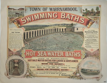
Poster - Recreation, Town of Warrnambool Swimming Baths, ca. May 1884
The poster advertises these Swimming Baths as “the most complete in the Southern Hemisphere”. In February 1877 a Baths Company (1050 shares) was formed in the town of Warrnambool for the establishment of the baths at the south end of Gillies Street. The baths were filled with sea water from Lady Bay, originally pumped by a windmill situated near the current Surf Lifesaving Club and carried by iron pipes to the Public Baths; later the water was pumped by a gas motor. Hot and cold fresh water baths were advertised. The gentlemen’s bath was 100 feet long and 50 feet wide, of graduating depth. A second bath, solely for ladies, was 60 feet long by 30 feet wide. Hot Sea water Baths were also part of the institution, and were sought after for their ‘wonderful curative powers’, and ‘incomparable’ as a ‘tonic for the feeble’. In June 1881 the Hot Sea Baths were opened, and both hot and cold water baths were supplied at reasonable charges. Patrons came from near and far to receive the benefits. The manager of the Baths was J. Kirkpatrick. The Baths Company struggled for several years without success, so in 1883 the baths were sold to the Borough Council for 1250 pounds. The original shareholders received nothing for their outlay; the overdraught was over the sale price. In May 1884 the Council announced that an estimated they has spent 1000 pounds in improving the baths since purchasing them and were now returning an income of 11 per cent. Historically significant to Warrnambool and the recreational facilities available in the 1880s to 1900s. The remains of the baths are still visible to the public today.Poster on heavy cream paper, landscape orientation, with coloured print. The poster advertises the Warrnambool Swimming Baths. It has several drawings such as Middle Island and the Merri River Mouth with vessels in the water, The inside of the Baths facility, the men's baths with the adjacent bathing rooms and figures in and out of the water, a cottage with figures in the garden, and fenced buildings with a windmill and aqueduct or pipes. The text describes the location and advantages, the opening times and various costs. It was printed in Ballarat by F.W. Niven & Co. Lithos."TOWN OF WARRNAMBOOL" "SWIMMING BATHS" "HOT SALT-WATER BATHS FOR LADIES AND GENTLEMEN" "HOURS FOR BATHING fROM 7 a.m. to 9 p. m. Closed on Sundays at 10 a.m." Single Bath 1s [1 shilling]; or 10s per Dozen Tickets" "HOURS FOR SWIMMING BATHS: Ladies and Gentlemen, from 6 a.m. to Sunset, Sundays 6 a.m. to 10 a.m." "Every information can be obtained from the Manager, J. Kirkpatrick" "HOT SEA-WATER BATHS ... strongly recommended by the Medical Faculty" "Hot and Cold Fresh Water Baths" "Showers etc." "LIST OF CHARGES ... Single Season Ticket, Single Monthly Ticket, Single Bath without towel ... with towel.. Tickets per dozen without towel, with towel..." "The Baths are situated at the end of Gillies Street, in the rear of the Post Office, and are of salt water pumped by gas motor continuously from the sea. The Swimming Bath is 100 feet long by 50 feet wide, of graduating depth; and a second bath for ladies' use solely, 60 feet long by 30 feet wide. The hot Sea-water Baths in connection with this institution have been extolled far and wide for their wonderfully curative powers in cases of rheumatism, sciatica, and nervous afflictions generally. As a tonic to an enfeebled system, they are incomparable, These Baths, the most complete in the Southern Hemisphere, have been recently re-erected and fitted with marble plunges, and everything provided for the comfort and convenience of invalids and visitors." "F.W. NIVEN & Co, LITHOS, BALLARAT"flagstaff hill, warrnambool, warrnambool swimming baths, hot sea water baths warrnambool, warrnambool baths company, f.w. niven & co, warrnambool therapudic baths, town of warrnambool, swimming baths, hot sea water baths, salt water baths, ladies' baths, gentlemen's baths, warrnambool town baths, j kirkpatrick -
 Greensborough Historical Society
Report, Examining Draughtsman's Report - Watts River Aqueduct, 20/07/1897
This Field Survey was commissioned by the Melbourne Board of Works and was used to position the Maroondah Aqueduct bridge north of Greensborough at its crossing point on the Plenty River. It incorporated the use of wrought iron water pipes and therefore is of lighter construction than other similar bridges in the district. It features a traverse of the Plenty RiverThe Maroondah Aqueduct bridge is a significant example of late 19th century engineering. A 4 page reproduction of an Office of Titles document. Copy of handwritten report includes maps.maroondah aqueduct, watts river aqueduct, bridge, greensborough, office of titles, 1897, wrought iron water pipes, plenty river, melbourne board of works -
 Eltham District Historical Society Inc
Newsletter, No. 157 July 2004
Contents: • Next meeting, Speaker Panel: On the Heritage Trail • Eltham Major Activity Centre • Maroondah Aqueduct Across the Plenty River • Eltham East Choir • President’s Notes • Alan Marshall’s Bungalow • Robert Bruce Ness 1917-2004 incl Ness Family History by Joy Ness • More News The Shire of Eltham Historical Society was formed in October 1967. The first newsletter of the Society was issued May 1978 and has been published continuously ever since on a bi-monthly basis. With the cessation of the Shire of Eltham in late 1994, the Society's name was revised to Eltham District Historical Society and this name first appeared with issue No. 103, July 1995. The collection of the Society's newsletters provides a valuable resource on the history of the Society's activities, office bearers and committee members, guest speakers and subjects of historical interest pertinent to the former Shire of Eltham and the Eltham District.A4 photocopied newsletter distributed to membersnewsletter, eltham district historical society, shire of eltham historical society