Showing 144 items
matching banksia
-
 Eltham District Historical Society Inc
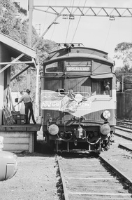
Photograph, George Coop, Single Motor Carriage Tait Parcels Van at Heidelberg Railway Station, 23 August 1983, 1983
Looking southwest towards Banksia Street overpassDigital TIFF file Scan of 35mm Kodak Safety 5062 black and white transparencyheidelberg railway station, parcels van, red rattler, single motor carriage, tait train -
 Eltham District Historical Society Inc
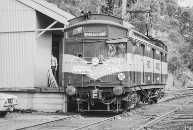
Photograph, George Coop, Single Motor Carriage Tait Parcels Van at Heidelberg Railway Station, 23 August 1983, 1983
Looking southwest towards Banksia Street overpassDigital TIFF file Scan of 35mm Kodak Safety 5062 black and white transparencyheidelberg railway station, parcels van, red rattler, single motor carriage, tait train -
 Eltham District Historical Society Inc
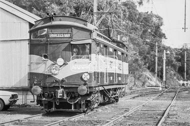
Photograph, George Coop, Single Motor Carriage Tait Parcels Van at Heidelberg Railway Station, 23 August 1983, 1983
Looking southwest towards Banksia Street overpassDigital TIFF file Scan of 35mm Kodak Safety 5062 black and white transparencyheidelberg railway station, parcels van, red rattler, single motor carriage, tait train -
 Eltham District Historical Society Inc
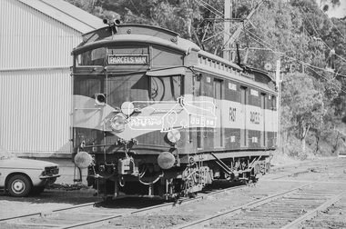
Photograph, George Coop, Single Motor Carriage Tait Parcels Van at Heidelberg Railway Station, 23 August 1983, 1983
Looking southwest towards Banksia Street overpassDigital TIFF file Scan of 35mm Kodak Safety 5062 black and white transparencyheidelberg railway station, parcels van, red rattler, single motor carriage, tait train -
 Bendigo Historical Society Inc.
Document - PETER ELLIS COLLECTION: WILDFLOWERS DECALS
Instructions for the use of Non-Fire Decal with five Wildflower Bouquet decals. The decals have Sturt's Dessert Pea, Banksia, Kangaroo Paw, Flannel Flower, Wattle, Bottlebrush, Heath? And Gum Nuts.ephemera, mementoes, flower decals, peter ellis collection, wildflower bouquet, decal -
 Whitehorse Historical Society Inc.
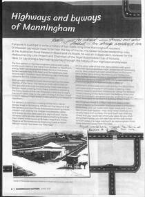
Article - Manningham Matters, Dr Richard Lay, Highways and Byways of Manningham, June 2021
August Schwerkolt walked between his properties at Northcote and Mitcham and probably crossed the Yarra River at the Banksia St bridge and took the ridge route which is now the Manningham, Doncaster and Mitcham Roads.August Schwerkolt walked between his properties at Northcote and Mitcham and probably crossed the Yarra River at the Banksia St bridge and took the ridge route which is now the Manningham, Doncaster and Mitcham Roads.non-fictionAugust Schwerkolt walked between his properties at Northcote and Mitcham and probably crossed the Yarra River at the Banksia St bridge and took the ridge route which is now the Manningham, Doncaster and Mitcham Roads.schwerkolt august, mitcham, doncaster road, mitcham road -
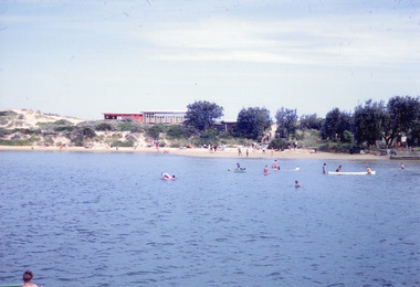 Lakes Entrance Historical Society
Photograph, Nelson Joan, 1980c
Colour photograph of the beach at the southern shore of Cunninghame Arm. It shows people swimming and paddling, also on the beach, coastal banksia and scrub on sand hummocks, surf lifesaving clubrooms in background. Lakes Entrance Victoriawaterfront, recreation -
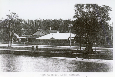 Lakes Entrance Historical Society
Photograph - Victoria House, 1920c
Photo taken prior to 1924, no memorial cypress treesBlack and white tinted photograph of Victoria House, showing a group of buildings on Esplanade. Rock wall on edge of lake. Two coastal banksias on verge of road, two men standing on rock wall. Lakes Entrance VictoriaVictoria House Lakes Entranceguesthouses, waterfront, architecture -
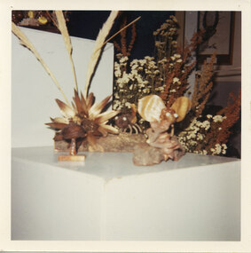
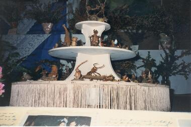 Halls Gap & Grampians Historical Society
Photograph - Coloured, C 1996
Wooden items are made from Banksia baueri. Local women made wooden items and jewellery of pressed flowers for sale (1960-1990s).Photo shows wooden items on a round display stand with a fringe tacked to bottom tier . Arranged flower vases cn be seen in background. events, wildflower show -
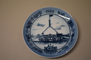 Warrnambool and District Historical Society Inc.
Plate souvenir, Royal Copenhagen, New parliament house
This item is a souvenir of the Bi- Centenary of Australia (1988) It features the new Parliament House in Canberra which was opened in May 1988 and cost more than one billion dollars to build and contains four thousand seven hundred rooms. This item came from the estate of a well known Warrnambool lawyer and is retained as a high quality souvenir of the Bi-Centenary of AustraliaCircular ceramic plate. White concave surface with blue drawing of Parliament House, Australian Coat of Arms, flowers including banksia, Sturt Desert Pea, eucalypt and seven pointed stars. Reverse has raised inner rim and includes text in blue. Front 1988 Reverse ROYAL COPENHAGEN DENMARK and crown. COPYRIGHT THE A.B.A 1981 REG.TRADE MARK OF THE A.B.A. USED UNDER LICENCE BY ROYAL COPENHAGEN NEW PARLIAMENT HOUSE, CANBERRA Logo Australia 1788-1988 Signature " Gorn Uestezaul"(?)parliament house, bi centenary of australia -
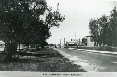 Lakes Entrance Historical Society
Photograph - Lakes Entrance, 1920c
Also 10 x 15 cm sepia copy, has remnants of glue of the back, little bit fadedBlack and white photograph of Esplanade, showing Maranui Guest House, Police Station, corner of Bellevue Guest House and Club Hotel in distance. Natural vegetation of Coastal Banksia on grass verge between road and waterfront, and beside Maranui Guest House. Lakes Entrance VictoriaThe Esplanade Lakes Entrancewaterfront, township, guesthouses, police -
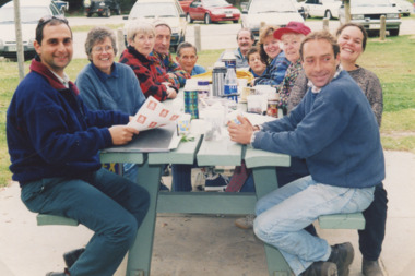 Lakes Entrance Historical Society
Photograph, Friends of the Environment, Lakes Entrance Victoria, 2000 c
Colour photograph of eleven people believed to be Friends of the Environment seated around a picnic table in what appears to be Lions Park Eastern Beach Lakes Entrance Victoria. Also another colour photograph of a man collecting seeds from grass in bushland coastal banksia in backgroundenvironment, politics, conservation -
 Halls Gap & Grampians Historical Society
Photograph - Coloured, C 1996
This is a photo of items made out of Banksia Bauerii. During the 1960's to the 1990's, local women made wooden items and jewellery of pressed flowers for sale at the Wildflower Show.The photo shows a display of wooden items standing on a white dip[lay stand. Dried flowers and grasses can be seen in the background, as well as a sketch on the wall to the right.events, wildflower show -
 Halls Gap & Grampians Historical Society
Photograph - Coloured, C 1996
The wooden items are made from Banksia Bauerii. During the 1960's to the 1990's, local women made wooden items and jewellery of pressed flowers for sale at the Wildflower Show.The photo shows a collection of wooden items displayed on a white stand. There is a brown cloth draped amongst the display.events, wildflower show -
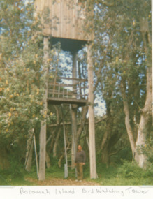 Lakes Entrance Historical Society
Photograph, Vera Bennett, Rotamah Island, Gippsland Lakes Victoria, 1/04/1989 12:00:00 AM
Colour photograph of the bird watching tower on Rotamah Island showing a timber hut and viewing platform supported on four timber poles accessed by steel ladders. Tower situated amongst coastal banksias Gippsland Lakes Victoria. Also another colour photograph of bird watching towerpeople, wildlife, topography, waterways -
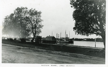 Lakes Entrance Historical Society
Photograph - Western Wharf, 1910c
Black and white photograph of the Western Wharf, colloquially known as the Post Office Jetty. It shows a steamer moored at the wharf beside a sail powered vessel. There is a shed at the end of the jetty, another near the shore. Some banksia trees on bank, also small tree inside tree guard. Unsealed road in foreground. Lakes Entrance VictoriaWestern Wharf Lakes Entrancejetties, township, ships and shipping -
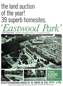 Ringwood and District Historical Society
Document - Folder, Eastwood Park Subdivision, Ringwood East, Vic. - Land Sale Circa 1967 - Site of former Eastwood/Eastfield Golf Course
Subdivision is advertised as including homesites on former Eastwood Golf Course fairways and land contours.Collection of subdivision maps, and double-sided advertisement for auction sale on Saturday, April 22nd, 1967, with summary of local features and services. Subdivision includes Croydon South streets, Andrew Crescent and Banksia Court. Agents - N.R. Reid & Co Pty Ltd, 173 Coleman Parade, Glen Waverley, Tel. 560 0355 A.H. 232 8423.Handwritten sales notations include "Vendor - Willcroft Development P/L 54-60 Southern Road Mentone Tel 93-1267 (Mrs. Morley). Lot 19 $5200, Lot 25 $4500, Lot 28 $3800, Lot 29 $3700, Lot 30 $3600. $400 deposit balance 3 yrs @ 7% $40 per month. All C/S to be prepared by vendor. 5% discount for cash." -
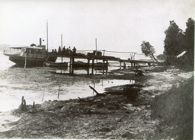 Lakes Entrance Historical Society
Photograph - SS Bogong, 1886c
This is the paired before paired photograph used in the 150 year Lakes Entrance 1858-2008 display.|The after paired photograph number is 01464.1|Also one 12 x 16 framed photograph used in room display.Black and white photograph of the foreshore, showing a small steamer moored at a rough timber jetty, known as 'the Landing' (later Barrier Landing). Three small rowing boats moored to jetty loading fish to steamer identified as ss Bogong. Five men on jetty. Sandy shore strewn with dead seaweed, coastal banksia on bank. Lakes Entrance Victoriajetties, waterfront, boats and boating, vegetation, room display -
 Broadmeadows Historical Society & Museum
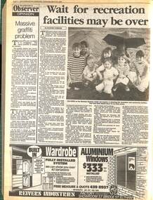
Article - Newspaper Article, Wait for Recreation Facilities May be Over
In 1990, the article "Wait for recreation facilities may be over" by Suzanne Carbone discussed the anticipated opening of new recreation facilities at Banksia Gardens Community Services in Broadmeadows, Victoria. These facilities, including sports fields and playgrounds, were expected to enhance community engagement and promote healthy lifestyles. This development marked a significant milestone for the culturally diverse and vibrant Broadmeadows community.The anticipated opening of new recreation facilities at Banksia Gardens Community Services in Broadmeadows, Victoria, in 1990 marked a pivotal moment for the community. These facilities, including sports fields and playgrounds, were set to significantly enhance community engagement and promote healthy lifestyles. This development underscored the ongoing efforts to support and uplift one of Australia's most disadvantaged and culturally diverse areas, reflecting the community's resilience and commitment to growth.Digital copy of page 8 of the Broadmeadows Observer, Wednesday 28 March 1990newspaper article, broadmeadows observer, broadmeadows banksia gardens, recreation, october 1990, suzanne carbone -
 Federation University Historical Collection
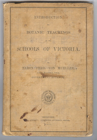
Book, Ferdinand von Mueller, Introduction to Botanic Teachings at the Schools of Victoria, 1877, 1877 (exact)
Ferdinand von Mueller was an examiner of botany at the Ballarat School of Mines (SMB) between 1880 and 1888. During that era he was active in donating related items to the School. When the Ballarat School of Mines Council agreed to introduce pharmacy and botany classes in 1879, it was apparent students would require access to botanical specimens in order to further their studies. Council members, who were inspired by the work of Baron Ferdinand von Mueller, authorised development of an area along the School's northern boundary, fronting Lydiard Street South, and oversaw the establishment of the new Botanical Gardens. Baron von Mueller took a practical role the development of SMB's Botanical Gardens from the beginning. He became a generous benefactor who 'donated collections of seeds and leguminous fodder plants, including valued grasses of interest and use to agriculturalists and graziers generally' to SMB over many years. Ferdinand von Mueller's entry on the University of Ballarat Honour Roll can be found at http://www.ballarat.edu.au/curator/honour-roll/honourroll_von_mueller.shtml A light brown, hardcovered book of 152 pages. Chapters include Eucalyptus Trees; Wattles or Acacias; Casuarinas or Sheoaks; Cypress Pines or Sandarac trees; Exocarpos trees of Natice Cherry trees; Mistletoes; Native Honeysuckles or Banksias; Bellflower, Lobelia and Goodenia; Heaths; Correas; Mallow; Buttercups and Clematis; Cruciferous Plants; Mints; Orchids; grasses; ferns. The book has numerous botanical line drawings, and a comprehensive index.Inside front cover "J. Clement Souter M.D."victorian, schools, botany, ferdinand von mueller, von mueller, botanic illustrations, j. clement souter -
 University of Melbourne, Burnley Campus Archives
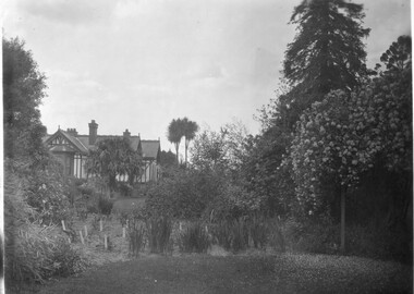
Photograph - Black and white print, Principal's Residence, 1913
Note from T.H. Kneen 13 February 1991, "Right hand tall tree is Californian Redwood. Over Pergola-Banksia Rose." On 19 November 1991, "Weatherboard construction of right rear of residence was modified/replaced to provide a bedroom for Mr. McLennan's family - he had 6 daughters. That room was later converted to a bathroom with three large storage cupboards." 2 copies black and white photograph. B91.17 and B91.18. View of various trees, shrubs and flowers. House on rise. On reverse "1913."trees, shrubs, flowers, californian redwood, mr. mclennan, principal's residence, principal's house, cordyline -
 Broadmeadows Historical Society & Museum
Photograph, Mural, c 1987
The photograph was published in the Broadmeadows Observer as part of an article highlighting community support initiatives. It features a mural located in the Banksia Gardens estate, which was painted by local residents. The project received funding from several sources, including the Ministry of Arts, the Community Arts Board, the Ministry of Housing, and Broadmeadows Health Services. This mural stands as a testament to the collaborative efforts of the community and various organisations in fostering a supportive and vibrant neighbourhood. The mural featured in the photograph, published in the Broadmeadows Observer, held significant cultural and community value. Located in the Banksia Gardens estate, this artwork was created by local residents and symbolised the collective spirit and creativity of the community. The project was made possible through the generous support of the Ministry of Arts, the Community Arts Board, the Ministry of Housing, and Broadmeadows Health Services. This mural not only enhanced the aesthetic appeal of the area but also served as a lasting testament to the power of community collaboration and the positive impact of public art initiatives.Black and white photograph on glossy photographic paper.Reduce/to/66%/P6.3/OBS/28-10-87banksia gardens estate, broadmeadows, broadmeadows observer, 1987 -
 Australian Army Museum of Western Australia
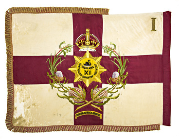
Regimental Colour - 1st Battalion, 11th Australian Infantry Regiment (Perth Regiment)
Purchased from Regimental funds in 1910 and presented by HE the Governor of WA Sir Gerald Strickland, KCMG, at a parade held on the Esplanade, Perth, 18 February 1911. Consecrated by the Right Reverend COL. Riley, DD, VD, Senior Chaplain of the Australian Commonwealth Military Forces. This colour was subsequently inherited by successor units to the 11th Australian Infantry Regiment (Perth Regiment), including 88th (Perth) Infantry, 11th Battalion (The Perth Regiment) and 11th/16th Battalion. The colour was handed over to the Perth City Council at a special parade of the 11th/16th Battalion held in Forrest Place on 2 June 1930, and was laid up in the Council Chambers in Murray Street. Together with the other historic colours handed over at the time, this colour later went into storage when Council moved premises in the early 1960's. Perth City Council had some restoration work carried out on these colours in 1975 and later had them on display in their display room at Council House, St Georges Terrace. They were subsequently placed in storage again. Following negotiations by the Army Museum of WA Perth City Council passed on these colours to the Museum in November 1993 Red George Cross on a white background with red and white fringe. In the centre the regimental badge in gold within a wreath of Western Australian kangaroo paw and banksia, surmounted by the Crown. Below the wreath is the Battle Honour "SOUTH AFRICA 1900-02". In the upper canton is the roman numeral "I" (Note:- The official Battle Honour for South Africa granted to 11th Australian Infantry Regiment under Military Order 123/1908 and subsequently published in the Australian Army List, was "South Africa 1899-1902") regimental colour, military heraldry, battle honour -
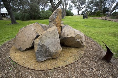 Bayside Gallery - Bayside City Council Art & Heritage Collection
Sculpture, Ellen José, Boon wurrung Blossom, 2008
The bluestone is laid on crushed yellow ochre sandstone, with the base encircled by indigenous flowering plants. Each rock represents one of the six clans that made up the Boon wurrung. For thousands of years, Boon wurrung women and children congregated in this area during special periods in spring and summer. The area was rich in seafood and had fresh water wells dotted around it. Among the Banksia trees that provided shelter, grew indigenous plants and flowers through which the women made garlands to wear in their hair.boon wurrung, blossom, sculpture, public art, indigenous, bayside indigenous coastal trail, ellen josé, ellen jose, bluestone, sandstone -
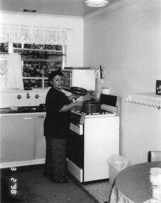 Broadmeadows Historical Society & Museum
Photograph, Gulcan Cooks Up a Treat, 3 February 1998
This item is part of a series of images regarding social housing in Broadmeadows. Titled "Gulcan Cooks Up a Treat Public Housing" / "Broadmeadows 1998," the photograph features a woman standing at a stove, cooking in a house within the Banksia Gardens estate. This image captures a moment of daily life and highlights the personal and communal aspects of living in public housing. It provides a glimpse into the domestic environment and the social fabric of the community during that period, emphasizing the importance of home and family within the context of social housing.The photograph titled "Gulcan Cooks Up a Treat Public Housing" / "Broadmeadows 1998" holds significant historical and cultural value. It features a woman, Gulcan, standing at a stove and cooking in a house within the Banksia Gardens estate. This image is part of a series documenting social housing in Broadmeadows and provides a poignant glimpse into the everyday lives of residents. It highlights the personal and communal aspects of living in public housing, emphasising the importance of home, family, and community. The photograph captures the essence of domestic life and the social fabric of the community during that period, offering valuable insights into the lived experiences of those in social housing.A black and white photograph on glossy photographic paper of a woman in a kitchen."Gulcan Cooks Up a Treat Public Housing"/"Broadmeadows 1998"broadmeadows, social housing, cooking, banksia gardens, 1998 -
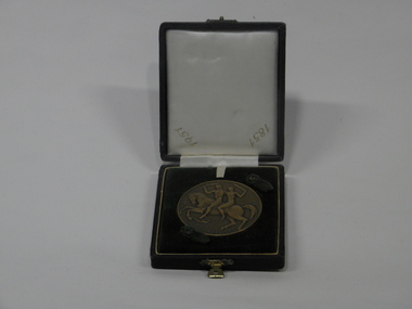 Hepburn Shire Council Art and Heritage Collection
Medal, 1951 Commemorative Plaque, 1951
Medal commemorating the Centenary of Government of Victoria and the Discovery of Gold, commissioned by the Victorian Government and gifted to the Shire of Glenlyon. Designed by Andor Mészáros and minted by K.G. Luke, Melbourne, 1951. 1951 marked the centenary of Victoria's separation from the colony of New South Wales. As part of the celebrations, the Victorian Government commissioned this medal from Andor Meszaros. Drawing on his classical background, Mészáros developed the imagery for 'Equality and Justice through Freedom'. The man holding the torch represents equality; the blindfolded woman holding a sword is the symbol of justice, and both are mounted on a horse that has broken its shackles. Features on the reverse a design of a banksia and bottlebrush. There was another version of this medal which depicted a pair of gold prospectors on the reverse.This medal was presented to the Shire of Glenlyon in 1951. For over half a century, sculptors Andor (1900-1973) and Michael (1945- ) Meszaros have created medals that reflect the high points of life in Australia. From major awards and portraits of eminent Australians to artwork celebrating popular culture and the natural world, these objects illuminate our culture and history. Grounded in a centuries-old European art tradition, the medals create connections across disciplines and link such diverse subjects as scientific advances, religious themes, sport, the performing arts and motherhood. Through their public and private commissions and their personal artworks, the Meszaros sculptors have defined the modern Australian medal.Bronze medal with images and text insetObverse Description: Horse bounding left, broken shackles on foreleg, carrying woman holding sword and man holding torch; around, EQUALITY AND JUSTICE THROUGH FREEDOM Artist's name behind horse's tail: A MESZAROS Reverse Description: Stake supporting plant; above, CENTENARY OF GOVERNMENT OF VICTORIA 1851 - 1951; inscribed, Presented to / the Shire of / Glenlyon / 1951 Artist's initials to left of stakeglenlyon, hepburn shire, centenary of government, centenary of gold discovery, history of victoria, victorian governement, meszaros, kg luke, commemorative, commemorative plaque, centenary 1951 -
 Bayside Gallery - Bayside City Council Art & Heritage Collection
Painting - oil on canvasboard, Gregory Alexander, Ten Wednesdays at Rickett's Point, 2016-18
oil on canvasboardrickett's point, landscape, tree, vegetation, port phillip bay, bay, banksia, fence, beaumaris, bayside, gregory alexander, painting -
 University of Melbourne, Burnley Campus Archives
Photograph - Black and white and colour slides, colour negative, Miscellaneous Horticulture, 1947-1985
57 slides and 1 negative. (1) "1947 Rolling the surface," in front of the newly constructed Administration Building. (2) "5-5-60 Same tree 7 months later-New Growth." (3) Men standing around a large horticultural machine. (4) "Lawns Housing Com" Aug "66?" (5) "Flemington Racecourse." (6) "Mustard-Cover Crop. 1960." (7) Tree climbing. (8) "Grafting-scions. BHC." (11) "Mildura-Soil Probe Oct 67." (12) Virus tested stock trees & layout Flemings Apr 70." (13) "Best's Winery Mar 75." (15, 16) Best's single student and group. (17) "Ploughing-Diagram to show incomplete cover of trash? Farm Practices." (18) "Spraying Hand Equipment for Insect Control in and around Buildings USA Yearbook 1952." (19) "Pasture Harrows." (20) "Mould Board Plough-Tractor." (21) "Disc Harrows-Offset-Tractor." (22) Tyne Cultivator-for Tractor." (23) See B91.258." (24) Burnley College libary. (25) "Irrigation-Delver Tatura 12/59." (26) "Tatura 12/59 Delver Ferguson T." (27) "Wilson's Prom? date." (28) "Wilson's Promontary Nov 1960 lunch." (29) "W. Prom." (30) Camp 1957 Wilson's Promontary." (31)" Longeronong Field Day 1964 Machinery Combination (Small)." (32, 33) "Longeronong Field Day 1964 Machinery Cultivating." (34-36) Photographs of plants in book. (35) Alnus? (37) "Meterosideros excelsa." (38) "Rhipsalidopsis rosea." (39) "Protea neriifolia." (40) Banksias-Species." Insects: (41) "Lacewing larva." (42) "Mites Aug 75." (43) "Yellow Mite, Red Spider (Arachnida)." (44) "Jassid-Life Cycle 9/51." (45) "Grape Fruit Crop (Florida) Destroyed by Fruit Fly. Animals without backbones." (46) "Jassid-Vegetable 9/51." (47) "Field Day 57 (Fruit Fly-Enlarged)." (48) "Field Day 57 (Fruit Fly-Stages)." (49) Insect Life Cycle. (50) "Comatibility (sic) Chart." for Insecticides & Fungicides. (51) "Insecticides-Toxicity." (52) "Life Cycle of the Leather Jacket." (53) "Grasshopper-Head Dissected Mouth Parts." (54) "Types of Antennae." (55) "Spider Mites USA Yearbook 1952." (56) "Cultivator." (57) "Organic Phosphates." (58) Negative Isopogon anemonifolius.administration building, lawns, flemington racecourse, mustard-cover crop, tree climbing, grafting, mildura, soil probe, pests, machinery, excursions, tatura, library, wilsons promontory, plants, alnus, zygocactus, schlumbergia, feijoa, acca sellowiana, protea neriifolia, banksia, isopogon anemonifolius -
 Surrey Hills Historical Society Collection
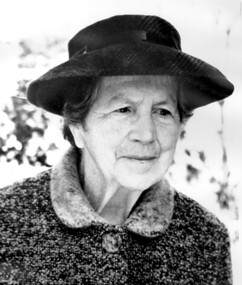
Photograph, Matron Elizabeth Maitland Anderson
Elizabeth Maitland Anderson was born c1887, daughter of William Anderson and Elizabeth MacKay. After she retired she lived at the Loyal Orange Lodge in Station Street, Box Hill South. She died on 14 May 1974 at Box Hill. She was cremated and ashes interred at Springvale Cemetery – Banksia, Wall H, Niche 302. Elizabeth Anderson opened Mosgiel Prvate Hospital in 1923 and was the Matron there from 1923-1950. She had been Matron of the Queen Victoria Hospital for four years. She lived next to the hospital at 297 Mont Albert Road from 1923-1930s. 'Mosgiel' was very highly regarded by medical practitioners and patients alike. After her retirement in 1950, along with with Doctors Roberta and Agnes Donaldson, she opened the Elgar Private Nursing Home in Elgar Road. Elizabeth Anderson was particularly involved with Moral Re-Armament and supported activities that took place in the Melbourne Home and Centre for Moral Re-Armament.A black and white photograph of an older lady wearing a hat and a coat.mosgiel private hospital, queen victoria hospital, elgar private nursing home, elgar road, mont albert road, nurses, nursing homes, health professionals, melbourne home and centre for moral re-armament, miss elizabeth maitland anderson, dr roberta donaldson, dr amelia roberta donaldson, dr agnes donaldson -
 Eltham District Historical Society Inc
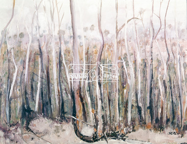
Photograph, "Pindarri" - John Serle, 1968, 1971
Pindarri was the name of the property on which artist John Serle lived on Pindari Road, St. Andrews. Colour painting reproduced on page 11 of "Pioneers & Painters: One hundred years of Eltham and its Shire" by Alan Marshall (1971). This chapter 1 "In the beginning" gives a physical description of the area: "Thick forest covered all the higher mountain ranges .. These areas were all heavily timbered, associated grasslands and eucalyptus extending from the thick forest country across undulating hills to the Yarra... The timber in general is gum, oak and Banksia, the two later are small, the gum two to four feet of diameter and from then to thirty feet high; on some of the low ground somewhat larger. The forest was open with little scrub..." The artist John Serle (born 1928) was the first local artist to become a councilor for the Shire of Eltham. He also worked for the Shire of Eltham grading roads. The Shire of Nillumbik hold a similiar painting in their collection (access via Victorian Collections) titled: Untitled (bush) Donor details on file. Location of original painting unknown. Most probably held in Serle family collection. Painting produced in 1968. Reproduced in "Pioneers and Painters", 1971 This photo forms part of a collection of photographs gathered by the Shire of Eltham for their centenary project book,"Pioneers and Painters: 100 years of the Shire of Eltham" by Alan Marshall (1971). The collection of over 500 images is held in partnership between Eltham District Historical Society and Yarra Plenty Regional Library (Eltham Library) and is now formally known as the 'The Shire of Eltham Pioneers Photograph Collection.' It is significant in being the first community sourced collection representing the places and people of the Shire's first one hundred years.4 x 5 inch colour reversal film (1) Condition: May not be true to colour of original work. Scanned from a 4 x 5 inch colour transparency which was taken c.1970 (approx. 50 years old) and which has undergone significant colour degradation towards the red spectrum. Allowances made for colour cast correction in scan with best guess for white balance. Significant light flare is reflected off glossy surface of original work at camera lens at lower left and right sides causing quality issues.pioneers and painters, sepp, shire of eltham pioneers photograph collection, john serle, pindarrri, bush