Showing 345 items matching "basins"
-
 Eltham District Historical Society Inc
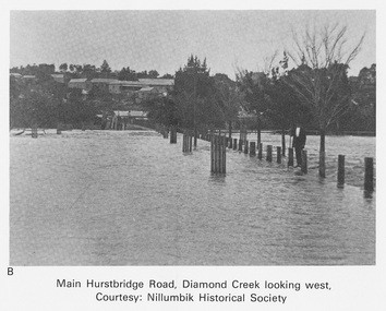
Work on paper (Sub-Item) - Photograph, Main Hurstbridge Road, Diamond Creek looking west
Undated black and white photograph of Main Hurstbridge Road, Diamond Creek in flood looking west. Nillumbik Historical Society collectionflood, diamond creek, nillumbik historical society -
 Eltham District Historical Society Inc
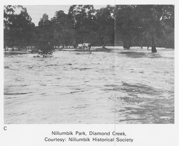
Work on paper (Sub-Item) - Photograph, Nillumbik Park, Diamond Creek
Undated black and white photograph of the Diamond Creek in flood, Nillumbik Park, Diamond Creek. Cattle take refuge on a high point. Nillumbik Historical Society collectionflood, diamond creek, nillumbik historical society -
 Eltham District Historical Society Inc
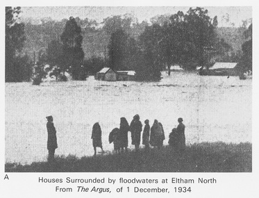
Work on paper (Sub-Item) - Photograph, Houses surrounded by floodwaters at Eltham North
"The house (centre) at North Eltham in which Mr. and Mrs. William Frizell, an elderly couple, were marooned by flood waters. When this photograph was taken late yesterday afternoon the couple were still inside the house, and through a ventilator they had stuck a red flag which they waved from time to time. The house on the left belongs to Mr. Leads, who also was marooned." - The Argus 1 December 1934. John William Frizell, painter and his wife Sarah Jane are registered at Glen Park, Eltham in the 1924 Electorial Roll This was most probably the Diamond Creek in flood. In 1934 extensive flooding of the Yarra River and Diamond Creek sets new records for flood plain level (via Chronology of Eltham, EDHS) flood, frizell, leads, argus, glen park, eltham north, flooding, marooned, diamond creek -
 Eltham District Historical Society Inc
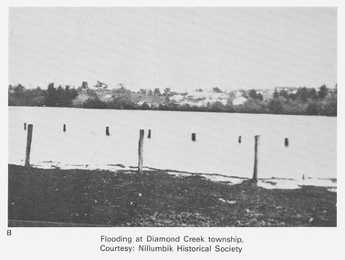
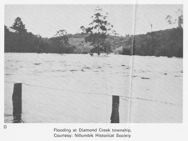
Work on paper (Sub-Item) - Photograph, Flooding at Diamond Creek Township
Black and white photograph of the Diamond Creek in flood at Diamond Creek township in 1934. In 1934 extensive flooding of the Yarra River and Diamond Creek set new records for flood plain level (Eltham Chronology EDHS) Nillumbik Historical Society collectionflood, diamond creek, flooding, nillumbik historical society -
 Eltham District Historical Society Inc
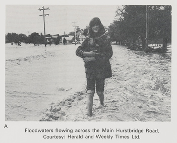
Work on paper (Sub-Item) - Photograph, Floodwaters flowing across Main Hurstbridge Road, Diamond Creek Township, 8 April 1977
Black and white photograph of young woman walking through floodwaters, possibly carrying an animal. The Diamond Creek in flood at Diamond Creek township, 8 April 1977 Herald and Weekly Times collectionflood, diamond creek, flooding, herald and weekly times, rescue -
 Eltham District Historical Society Inc
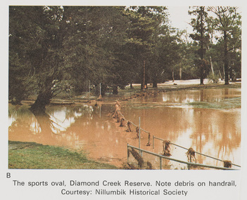
Work on paper (Sub-Item) - Photograph, The Sports Oval, Diamond Creek Reserve, Diamond Creek Township, 8 April 1977
Colour photograph. Note debris on the rail fencing around the oval. The Diamond Creek in flood at Diamond Creek township, 8 April 1977 Nillumbik Historical Society collectionflood, diamond creek, flooding, oval, nillumbik historical society, rail -
 Eltham District Historical Society Inc
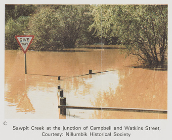
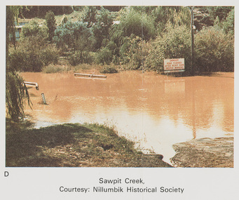
Work on paper (Sub-Item) - Photograph, Sawpit Creek at the junction of Campbell and Watkins Street, Diamond Creek Township, 8 April 1977
Colour photograph. Sawpit Creek at the junction of Campbell and Watkins Street, Diamond Creek Township. The Diamond Creek in flood at Diamond Creek township, 8 April 1977 Nillumbik Historical Society collectionflood, diamond creek, flooding, nillumbik historical society, give way, sawpit creek, campbell street, watkins street -
 Eltham District Historical Society Inc
Work on paper (Sub-Item) - Photograph, Sawpit Creek in flood, Diamond Creek Township, 8 April 1977
Colour photograph. Sawpit Creek near the Diamond Creek in flood at Diamond Creek township, 8 April 1977 A road sign reads" DANGER ROAD FLOODED AFTER HEAVY RAIN OBSERVE MARKERS" Nillumbik Historical Society collectionflood, diamond creek, flooding, nillumbik historical society, give way, sawpit creek, campbell street, watkins street, danger, road sign -
 Eltham District Historical Society Inc
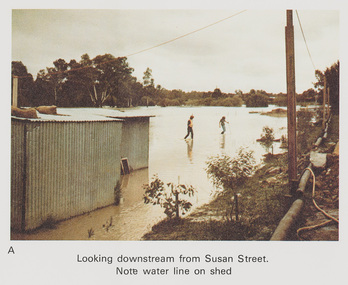
Work on paper (Sub-Item) - Photograph, Flooding, looking downstream from Susan Street, Eltham 8 April 1977
Colour photograph. Looking downstream from Susan Street, Eltham , 8 April 1977. Note water line on shed flood, diamond creek, flooding, susan street -
 Eltham District Historical Society Inc
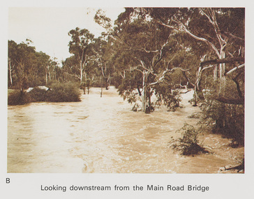
Work on paper (Sub-Item) - Photograph, Flooding, looking downstream from Main Road Bridge, Eltham 8 April 1977
Colour photograph. Looking downstream on the Diamond Creek from Main Road Bridge, Eltham , 8 April 1977. flood, diamond creek, flooding, main road, eltham -
 Eltham District Historical Society Inc
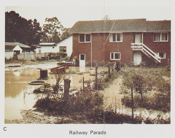
Work on paper (Sub-Item) - Photograph, Flooding, 75 Railway Parade, Eltham 8 April 1977
Colour photograph. Flooding of Diamond Creek at the rear and side of property at 75 Railway Parade, Eltham , 8 April 1977. flood, diamond creek, flooding, eltham, 75 railway parade -
 Eltham District Historical Society Inc
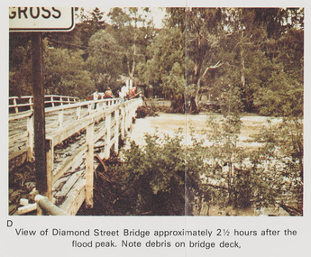
Work on paper (Sub-Item) - Photograph, Flooding, View of Diamond Street Bridge, Eltham 8 April 1977
Colour photograph. Flooding of Diamond Creek at Diamond Street Eltham bridge approximately 2 1/2 hours after the flood peak. Note debris on the bridge deck. 8 April 1977. flood, diamond creek, flooding, eltham, diamond street, bridge -
 Eltham District Historical Society Inc
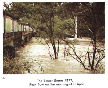
Work on paper (Sub-Item) - Photograph, Main Road Bridge, Eltham peak flow of flood 8 April, 1977
Colour photograph. Flooding of Diamond Creek at Main Road Bridge, Eltham peak flow of flood. Easter storm, 8 April, 1977flood, diamond creek, flooding, eltham, bridge, main road -
 Eltham District Historical Society Inc
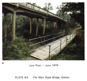
Work on paper (Sub-Item) - Photograph, Main Road Bridge, Eltham low flow of Diamond Creek, June 1979
Colour photograph.Main Road Bridge, Eltham low flow of Diamond Creek with wooden pedestrain bridge constructed over the creek as a continuation of the walking and biking trail, June 1979diamond creek, eltham, bridge, main road, pedestrain bridge, trail -
 Eltham District Historical Society Inc
Work on paper (Sub-Item) - Photograph, Arthurs Creek Road Bridge, Hurstbridge, 1885
Black and white photograph.bridge, hurstbridge -
 Eltham District Historical Society Inc
Work on paper (Sub-Item) - Photograph, Monash Bridge, Arthurs Creek Road, Hurstbridge, 1917
Black and white photograph of the new bridge opened in 1917.bridge, hurstbridge -
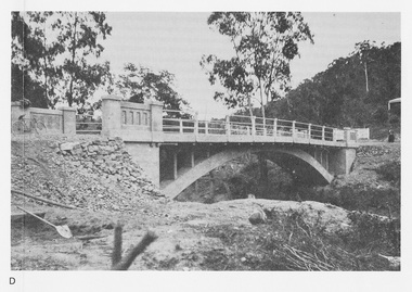
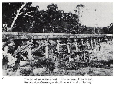 Eltham District Historical Society Inc
Work on paper (Sub-Item) - Photograph, Trestle bridge under construction between Eltham and Hurstbridge
Black and white photograph of the bridge under construction. The line opened at Hurstbridge in 1912.bridge, hurstbridge -
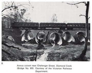 Eltham District Historical Society Inc
Work on paper (Sub-Item) - Photograph, Armco culvert near Challenger Street, Diamond Creek
Black and white photograph. A passenger train crosses Victorian Railways Bridge No 65 near Challenger Street, Diamond Creek. A series of steel culverts or tunnels carrying a stream have been constructed beneath the railway bridge.bridge, culvert, train, challenger street -
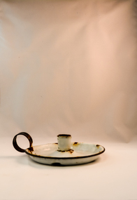
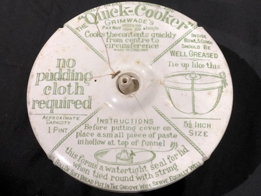 Mont De Lancey
Pudding Basin, Grimwade's, Circa 1911
White ironstone "Quick-Cooker" pudding basin with lid and written cooking instructions in green."Gold Medal London 1911 The Quick-Cooker" Grimwades's Pat Nos 12835/09 and 1504/09 and 12181/11 Excellent for stews of all kinds" etcpudding basins -
 Kiewa Valley Historical Society
Candle Holder x2, circa early 1900
Historically this item was before electricity lighting was available. There is no protection around the candle to prevent wind or air movement from extinguishing the candle flame therefore this means of night illumination was used within a house environment. It could be easily moved from room to room but would have insignificant "candle power" to lighten more than a few metres around it. This item was before kerosene lamps, gas lighting and electric/battery lamps This candle holder would have been used within the homes of Kiewa residences to illuminate the way from room to room where there were no other forms of lighting available. As it is relatively light in weight and with a finger/s grip it is highly portable and was in time replaced by battery powered torches. It was used in a period where home, or local made candles were a necessity of living. This Item was used before battery powered torches were invented. Although candles are still used in the late 20th and after, their fundamental use has changed and they function more as a mood enhancement item or as a back up for an electrical power failure and the alternative battery powered torch also runs out of power.1. This small basin shaped candle holder is formed of metal and sealed with a pale grey enamel skin. It has a black painted edge and finger holder. It has a raised vertical spout for the securing of the candle. The bottom of the basin is contoured from the candle base to the outer edge to allow for melted candle wax to be safely held within the basin. 2. As above. The handle is rusty but otherwise in good condition. candle-holder, portable light enamel household goods -
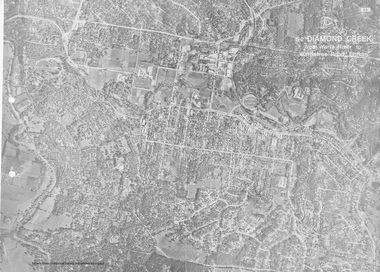 Eltham District Historical Society Inc
Work on paper (Sub-Item) - Aerial Photograph, Diamond Creek from Yarra River to Wattletree Road, Eltham
Black and white aerial photograph witrh key features around the central place of Eltham township marked inluding Yarra River, Main Road, Bridge Street and Ryans Road, Eltham North land development, real estate, aerial view, eltham, eltham north -
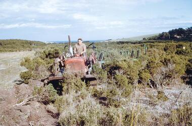 Phillip Island and District Historical Society Inc.
Photographs/Slides, Laurie Dixon, 1961
Five of a collection of slides donated by Laurie Dixon. Water was pumped from Candowie Reservoir to nearby Almurta Basin and gravity fed to Wimbledon Heights Storage Basin. These open water basins were two main components of the water distribution of the day and supplied the area from 1964 to 1989. The Almurta and Wimbledon Heights Storage Basins were decommissioned in 1999 when the San Remo Basin was improved an now is the vital link in the transfer of water from Candowie via the Purification Plant.Five of a collection of slides taken by Laurie Dixon. (Photographs scanned by E Alexander). The photographs are of the machinery used to clear the land for the reservoir constructed at Wimbledon Heights in September 1961 273-08 Robert Cleeland on TractorInscriptions of slides 273-09. Tourerpull & crawler at reservoir Sep. 61 273-10. Reservoir Sep 61 273-11. Reservoir Sep 61 273-12. Building reservoir Sep 61wimbledon heights reservoir, laurie dixon -
 Tatura Irrigation & Wartime Camps Museum
Album - Photo
Very early photographs of construction of Goulburn Weir, Waranga Basin and channels. Post card of Waranga Basin QuarrySilver and black photo album, flower logo.album, photo, goulburn weir, waranga basin, tatura, irrigation, books, albums, rural, industries -
Tatura Irrigation & Wartime Camps Museum
Photograph, Waranga Basin, c.1926
Photographs taken by Mrs. Craven. Waranga Basin inlet and other, probably taken on the opening of the upgraded Basin c.1926B & W. photos. -
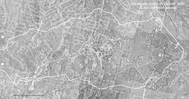 Eltham District Historical Society Inc
Work on paper (Sub-Item) - Photograph, St Helena East, St Helena West and Eltham West drains, ca 1980
black and white aerial photograph with boundary and drains marked over three page fold out eltham, st helena, drains, aerial view -
 Kiewa Valley Historical Society
Basin - Enamel, 1940's
The Tawonga District Hospital opened in the early 1950's in the Kiewa Valley to treat local patients from Mt Beauty and the residents of the KIewa Valley. The State Electricity Commission of Victoria assisted with the building of the hospital as the population of Mt Beauty increased with the S.E.C. workers and their families during the construction of the Kiewa Hydro Electric Scheme. The Tawonga Hospital was later relocated to Mt Beauty. All the enamel equipment was eventually replaced with stainless steel.This grey enamel basin is large with a royal blue lip. It was used in the Tawonga District Hospital to wash patients.enamel basin, tawonga hospital, medical, kiewa hydro electric scheme -
Tatura Irrigation & Wartime Camps Museum
Book, The Supply of Water for Irrigation in Victoria 1881-1981, 1988
Early history of irrigation in Victoria. From 1981 the name changed from State Rivers & Water Supply Commission to Rural Water Commission. Major changes have occurred sinceCream plasticized cover. Black writing. Photo of horse team and scoop working on Waranga Basin or channelsirrigation, books, history, local, rural, industry -
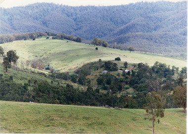 Lakes Entrance Historical Society
Photograph, Tambo Shire, 1994
Also second similar copyColour photograph taken at The Basin, showing hilly farmland, dense forest on ranges in distance. Buchan Victoriatopography, vegetation -
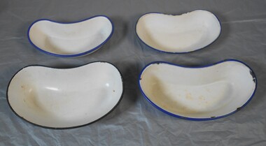 Bendigo Historical Society Inc.
Functional object - Kidney dishes
Four enameled kidney dishes. A kidney dish (British English) or emesis basin (American English) is a shallow basin with a kidney-shaped base and sloping walls used in medical and surgical wards to receive soiled dressings and other medical waste. The shape of the dish allows it to be held against the patient's body to catch any falling fluids or debris. Various sizes of emesis basins are common in healthcare settings. Aileen and John Ellison Collectionmedical, kidney dish