Showing 514 items
matching black forest
-
 Marysville & District Historical Society
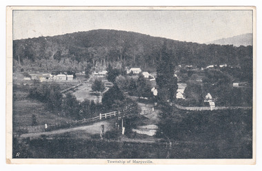
Postcard (item) - Black and white postcard, Nicholas John Caire, Township of Marysville, 1858-1918
One of a series of postcards of photographs taken by socialite photographer Nicholas John Caire. N.J. Caire had a great love for the area and in the late 1800's took many photographs of Marysville and its surrounds.One of a series of postcards of photographs taken by socialite photographer Nicholas John Caire. N.J. Caire had a great love for the area in and surrounding Marysville and in the late 1800's took many photographs of Marysville and its surrounds. N.J. Caire was born in 1837 in Guernsey. He arrived in Adelaide about 1860 along with his parents who encouraged his early interest in photography. He opened a studio in Adelaide in 1867 after traveling extensively throughout the Gippsland taking photographs. After marrying in 1870 he moved to Talbot in Victoria until 1876 when he opened a studio in the Royal Arcade in Melbourne. After 1885 N.J. Caire gave up his city work and made his home in South Yarra and devoted the rest of his life to outdoor photography, specializing in the bush, the gullies and the mountains of south-eastern Victoria. POST CARD The Address to be written on this side This space may be used for Correspondence/ within the Commonwealth at 1d. rate./ Foreign, charged ordinary letter rate. St. Fillans/ Narbethong This is the/ little village we/ visited last week/ E.L. Mrs R.D. Cole/ Mozart Villa/ Bethanga One penny Victorian postage stamp Date Stamp/ Illegible Date Stamp/ JA 16/ 6/ VICTORIA/ Illegiblemarysville, victoria, nicholas john caire, postcard, souvenir -
 Marysville & District Historical Society
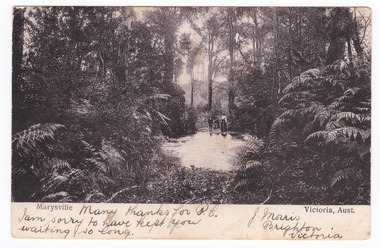
Postcard (item) - Black and white postcard, Nicholas John Caire, Marysville Victoria, Aust, 1858-1918
One of a series of postcards of photographs taken by socialite photographer Nicholas John Caire. N.J. Caire had a great love for the area and in the late 1800's took many photographs of Marysville and its surrounds.One of a series of postcards of photographs taken by socialite photographer Nicholas John Caire. N.J. Caire had a great love for the area in and surrounding Marysville and in the late 1800's took many photographs of Marysville and its surrounds. N.J. Caire was born in 1837 in Guernsey. He arrived in Adelaide about 1860 along with his parents who encouraged his early interest in photography. He opened a studio in Adelaide in 1867 after traveling extensively throughout the Gippsland taking photographs. After marrying in 1870 he moved to Talbot in Victoria until 1876 when he opened a studio in the Royal Arcade in Melbourne. After 1885 N.J. Caire gave up his city work and made his home in South Yarra and devoted the rest of his life to outdoor photography, specializing in the bush, the gullies and the mountains of south-eastern Victoria. Many thanks for P.C./ I am sorry to have kept you/ waiting so long. J. Morris/ Brighton/ Victoria POST CARD [THIS SPACE MAY BE USED FOR COMMUNICATION] ]FOR WRITING ADD (rest has been removed when stamp was removed) Mr Herman Frock/ Petersgaard/ Langebak Street/ Denmark Date Stamp/ MELBOURNE/ FEB 2?/ 4.33/ 1906 Date Stamp/ MASNEDSUND/ KALLEHAVE/ 24.3.06.1.4 Stamp/ BILL HOPKINS COLLECTION/ 21 KENSINGTON PARK ROAD W11/ NOTTING HILL GATE LONDON marysville, victoria, nicholas john caire, bill hopkins collection, postcard, souvenir -
 Marysville & District Historical Society
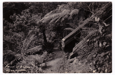
Postcard (item) - Black and white postcard, Forest of Arden Marysville, Unknown
Postcard of early photograph of the Forest of Arden near Marysville.Postcard of early photograph of the Forest of Arden near Marysville.POST CARD PLACE/ POSTAGE/ STAMP/ HEREforest of arden, marysville, forest, tree fern, postcard, souvenir, victoria -
 Marysville & District Historical Society
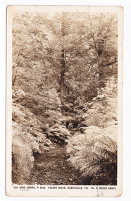
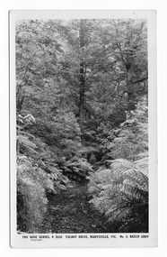
Postcard (item) - Black and white postcard, Rose Stereograph Company, Talbot Drive, Marysville, Vic. No. 5. Beech Grove, 1913-1967
A postcard in a series produced by the Rose Stereograph Company in Victoria, Australia as a souvenir of Marysville.A black and white photograph taken along Lady Talbot Drive, Marysville, Victoria, of the area known as the Beech Grove. The Beeches Rainforest Walk is a loop that starts at Taggerty Cascades before winding through Myrtle Beech and Mountain Ash woodland and is one of the many walking tracks in and around Marysville. It is accessible from Lady Talbot Drive which is a 24 kilometer scenic rainforest car journey which passes a number of walks and waterfalls in the Yarra Ranges National Park. Lady Talbot Drive is named after Lady Sarah Elizabeth, the wife of Sir Reginald Talbot, who was the Governor of Victoria from 25th April, 1904 to 6th July 1908. This postcard was produced by the Rose Stereograph Company as a souvenir of Marysville.POST CARD The "Rose" Set/ De Luxe A Real Photograph/ Produced in Australia Published by the Rose Stereograph Co./ Armadale, Victoria. This is just to remind you of/ Marysville - I am spending the/ weekend up here & thoroughly/ enjoying it./ Love to all of you L. McIver All best honey + thanks for/ a lovely day E. + P. F.talbot drive, marysville, victoria, beech grove, p. 2310, rose series postcard, postcard, souvenir, beeches rainforest walk, sarah elizabeth talbot, sir reginald talbot, mountain ash, myrtle beech -
 Marysville & District Historical Society
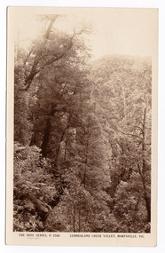
Postcard (item) - Black and white postcard, Rose Stereograph Company, Cumberland Creek Valley, Marysville, Vic, 1913-1967
A postcard in a series produced by the Rose Stereograph Company in Victoria, Australia as a souvenir of Marysville.A black and white photograph of a heavily forested valley leading up to a forested hill. The Cumberland Valley is near Cambarville which was a timber town near Marysville. Cambarville is notable for its giant mountain ash (Eucalyptus regnans) trees within the Cumberland Memorial Scenic Reserve, and relics from former sawmills and gold mining. The Big Culvert is located nearby on the Marysville - Woods Point Road, which was historically part of the Yarra Track. Cambarville was established as a timber mill town in the 1940s. Timber mill owners A Cameron and FJ Barton named Cambarville. They established the mill to salvage timber from trees destroyed in the 1939 bushfires. Cambarville was impacted by the 2009 Black Saturday bushfires and any remaining structures were destroyed.POST CARD The "Rose" Series/ De Luxe A Real Photograph/ Produced in Australia Published by the Rose Stereograph Co.,/ Armadale, Victoria.cumberland valley, marysville, victoria, p. 2330, cumberland creek, rose series postcard, postcard, souvenir, mountain ash, timber mill, mining, a cameron, fj barton, cambarville, big culvert, yarra track, black saturday bushfires, 1939 bushfires -
 Marysville & District Historical Society
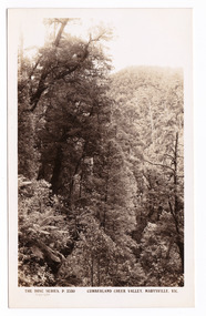
Postcard (item) - Black and white postcard, Rose Stereograph Company, Cumberland Creek Valley, Marysville, Vic, 1913-1967
A postcard in a series produced by the Rose Stereograph Company in Victoria, Australia as a souvenir of Marysville.A sepia photograph of a heavily forested valley leading up to a forested hill. The Cumberland Valley is near Cambarville which was a timber town near Marysville. Cambarville is notable for its giant mountain ash (Eucalyptus regnans) trees within the Cumberland Memorial Scenic Reserve, and relics from former sawmills and gold mining. The Big Culvert is located nearby on the Marysville - Woods Point Road, which was historically part of the Yarra Track. Cambarville was established as a timber mill town in the 1940s. Timber mill owners A Cameron and FJ Barton named Cambarville. They established the mill to salvage timber from trees destroyed in the 1939 bushfires. Cambarville was impacted by the 2009 Black Saturday bushfires and any remaining structures were destroyed.POST CARD THE "ROSE"SERIES/ DE LUXE/ REAL PHOTOS PRODUCED IN/ AUSTRALIA Published by the Rose Stereographs/ Armadale, Victoriacumberland valley, marysville, victoria, p. 2330, cumberland creek, rose series postcard, postcard, souvenir, cambarville, mountain ash, mining, timber mills, big culvert, yarra track, a cameron, fj barton, black saturday bushfires, 1939 bushfires -
 Marysville & District Historical Society
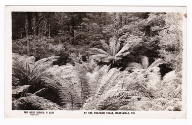
Postcard (item) - Black and white postcard, Rose Stereograph Company, By the Wolfram Track, Marysville, Vic, 1913-1967
A postcard in a series produced by the Rose Stereograph Company in Victoria, Australia as a souvenir of Marysville.A black and white photograph of a part of the forest that the Wolfram Track, which is part of the Wilks Creek Walking Track, runs through. The Wilks Creek Walking Track is in Marysville in Victoria. The Wolfram Track is named after the Wilks Creek Wolfram Mine which opened in around 1894. Wolframite is one of the principle ores of tungsten. The discovery was made in Wolfram Creek by a Mr Robinson who was probably a local of the district. Four creeks eventually proved to carry alluvial deposits of the ore; Wolfram Creek, Opas Creek, Quartz Creek and Main Creek. These creeks run south-east into Deep Creek, a tributary of the O'Shannassy River which, in turn, runs into the Yarra River.POST CARD The "Rose" Series/ De Luxe A Real Photograph/ Produced in Australia Published by the Rose Stereograph Co.,/ Armadale, Victoria.wolfram track, wilks creek walking track, walking track, marysville, victoria, p. 2334, rose series postcard, postcard, souvenir, p. 2332, wolframite, wolfram creek, opas creek, quartz creek, main creek, deep creek, o'shannassy river, yarra river, mining -
 Marysville & District Historical Society
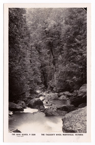
Postcard (item) - Black and white postcard, Rose Stereograph Company, The Taggerty River, Marysville, Victoria, 1913-1967
A postcard in a series produced by the Rose Stereograph Company in Victoria, Australia as a souvenir of Marysville.A black and white photograph of the Taggerty River in Marysville in Victoria.POST CARD The "Rose " Series/ De Luxe A Real Photograph/ Produced in Australia Published by the Rose Stereograph Co.,/ Armadale, Victoriataggerty river, marysville, victoria, p. 2338, rose series postcard, postcard, souvenir -
 Marysville & District Historical Society
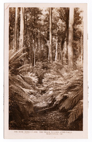
Postcard (item) - Black and white postcard, Rose Stereograph Company, The Track to Cora Lynn Falls, Marysville, Vic, 1913-1967
A postcard in a series produced by the Rose Stereograph Company in Victoria, Australia as a souvenir of Marysville.A black and white photograph of the track leading through the forest to the Cora Lynn Falls which is in the Cumberland Valley in Victoria. These falls are located on the Marysville-Wood's Point Road. Cambarville is notable for its giant mountain ash (Eucalyptus regnans) trees within the Cumberland Memorial Scenic Reserve, and relics from former sawmills and gold mining. The Big Culvert is located nearby on the Marysville-Woods Point Road, which was historically part of the Yarra Track. Cambarville was established as a timber mill town in the 1940s. Timber mill owners A Cameron and FJ Barton named Cambarville. They established the mill to salvage timber from trees destroyed in the 1939 bushfires. Cambarville was impacted by the 2009 Black Saturday bushfires and any remaining structures were destroyed. THE ROSE SERIES P. 4958/ COPYRIGHT/ THE TRACK TO CORA LYNN FALLS, MARYSVILLE, VIC. The reverse of postcard is illegible as it is covered by paper residue from when postcard was removed from an album. marysville, victoria, photograph, cora lynn falls, waterfalls, p. 4958, rose series postcard, rose stereograph company, souvenir, cambarville, marysville-wood's point road, eucalyptus regnans, cumberland memorial scenic reserve, mining, big culvert, yarra track, a cameron, fj barton, 1939 bushfires, 2009 black saturday bushfires, timber mills -
 Marysville & District Historical Society
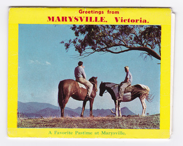
Postcard (item) - Colour photographs, Rose Stereograph Company, Greetings from MARYSVILLE, Victoria, 1960's
A pull-out postcard of colour photographs of attractions in an around Marysville in Victoria.A pull-out postcard of colour photographs of attractions in an around Marysville in Victoria. The postcard was produced by the Rose Stereograph Company on behalf of Marylands Guest House. Marylands was originally one of the ‘Mary’ chain of guesthouses and was one of several of the chain in Marysville. Marylands was destroyed in the 2009 Black Saturday bushfires along with nearly all the guesthouses in Marysville.M Published by the Rose Stereograph Co., Armadale, Victoria./ Color Transparencies by courtest Maryslands Guest House/ Copyrightmarysville, victoria, rose stereograph company, postcard, souvenir, marylands guest house, autumn, signpost corner, jock's lookout, kooringa, stevenson's river, steavenson river, stevenson's falls, forest -
 Marysville & District Historical Society
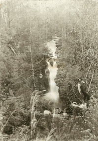
Photograph (item) - Black and white photograph, 1900's
An early black and white photograph of two men in the forest alongside the top level of Steavenson Falls in Marysville in Victoria.An early black and white photograph of two men in the forest alongside the top level of Steavenson Falls in Marysville in Victoria. The Steavenson Falls is named after the Victorian Assistant Commissioner of Roads and Bridges, John Steavenson who arrived in Victoria in the early 1860s.steavenson falls, marysville, victoria, waterfalls, john steavenson -
 Marysville & District Historical Society
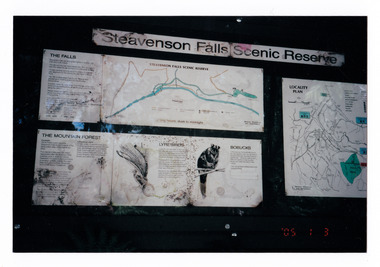
Photograph (item) - Colour photograph, 03-01-2005
Shows the sign at the Steavenson Falls Scenic Reserve.Shows the sign at the Steavenson Falls Scenic Reserve. This sign was destroyed in the 2009 Black Saturday bushfires. The Steavenson Falls is named after the Victorian Assistant Commissioner of Roads and Bridges, John Steavenson who arrived in Victoria in the early 1860s.'05 1 3 3.01.05. Marysville (from Helga Walsh)steavenson falls, steavenson falls scenic reserve, mountain forest, lyrebird, bobuck, mountain brushtail possum, marysville, victoria, john steavenson, 2009 black saturday bushfires -
 Marysville & District Historical Society
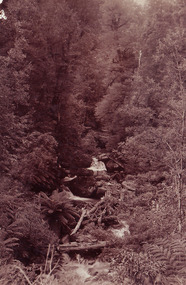
Photograph (item) - Black and white photograph, Unknown
... the heavily treed forest. Photograph Black and white photograph ...A black and white photograph of Steavenson Falls in Marysville in Victoria.A black and white photograph of Steavenson Falls in Marysville in Victoria. The Steavenson Falls are named after the Victorian Assistant Commissioner of Roads and Bridges, John Steavenson who arrived in Victoria in the early 1860s.steavenson falls, marysville, victoria, waterfall, john steavenson -
 Marysville & District Historical Society
Photograph (item) - Black and white photographs, Unknown
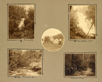
An album page with five photographs of 5 natural attractions in an around Marysville in Victoria.An album page with five photographs of 5 natural attractions in an around Marysville in Victoria.Steavenson Falls 18/ Steavenson River 21/ "Land of mountain or flood" 20/ a Mountain Stream 22steavenson falls, steavenson river, marysville, victoria, waterfalls -
 Marysville & District Historical Society
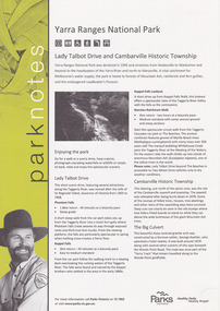
Flyer (item) - Information Flyer, Parks Victoria, park notes-Yarra Ranges National Park-Lady Talbot Drive and Cambarville Historic Township, June 2013
A flyer produced by Parks Victoria of information on Lady Talbot Drive and Cambarville Historic Township.A flyer produced by Parks Victoria of information on Lady Talbot Drive and Cambarville Historic Township. Lady Talbot Drive a 24 kilometer scenic rainforest car journey which passes a number of walks and waterfalls in the Yarra Ranges National Park. Lady Talbot Drive is named after Lady Sarah Elizabeth, the wife of Sir Reginald Talbot, who was the Governor of Victoria from 25th April, 1904 to 6th July 1908. Cambarville is notable for its giant mountain ash (Eucalyptus regnans) trees within the Cumberland Memorial Scenic Reserve, and relics from former sawmills and gold mining. The Big Culvert is located nearby on the Marysville-Woods Point Road, which was historically part of the Yarra Track. Cambarville was established as a timber mill town in the 1940s. Timber mill owners A Cameron and FJ Barton named Cambarville. They established the mill to salvage timber from trees destroyed in the 1939 bushfires. Cambarville was impacted by the 2009 Black Saturday bushfires and any remaining structures were destroyed. parks victoria, yarra ranges national park, lady talbot drive, lady talbot forest drive, cambarville, taggerty river, sir reginald talbot, lady sarah elizabeth talbot, phantom falls, keppel falls, keppel falls lookout, beeches rainforest walk, big culvert, cumberland walk, the big tree, the sitka spruce, cora lynn falls, sovereign view -
 Marysville & District Historical Society
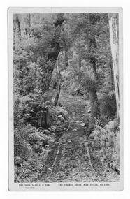
Postcard (item) - Black and white postcard, Rose Stereograph Company, Talbot Drive, Marysville, Vic. No. 4, View from Murray Pass, 1913-1967
An early black and white photograph of the view of the Taggerty River from Murray Pass near Marysville in Victoria.An early black and white photograph of the Taggerty River from Murray Pass near Marysville, Victoria. Murray Pass is located on the Lady Talbot Drive. Lady Talbot Drive a 24 kilometer scenic rainforest car journey which passes a number of walks and waterfalls in the Yarra Ranges National Park. Lady Talbot Drive is named after Lady Sarah Elizabeth, the wife of Sir Reginald Talbot, who was the Governor of Victoria from 25th April, 1904 to 6th July 1908. This postcard was produced by the Rose Stereograph Company as a souvenir of Marysville.POST CARD The "Rose" Series/ De Luxe A Real Photograph/ Produced in Australia Published by the Rose Stereograph Co./ Armadale, Victoria. Dear Harold/ This is the prettiest card I/ could get for you. Probably we will/ go this trip in a day or two./ Yours Nance xxx xxxmarysville, victoria, photograph, taggerty river, murray pass, lady talbot forest drive, 2309, postcard, souvenir, lady talbot drive, sir reginald talbot, sarah elizabeth talbot, rose series postcard -
 Marysville & District Historical Society
Postcard (item) - Black and white postcard, Rose Stereograph Company, Talbot Drive, Marysville, Vic. No. 5, Beech Grov, 1913-1967
A postcard in a series produced by the Rose Stereograph Company in Victoria, Australia as a souvenir of Marysville.A black and white photograph taken along Lady Talbot Drive, Marysville, Victoria, of the area known as the Beech Grove. The Beeches Rainforest Walk is a loop that starts at Taggerty Cascades before winding through Myrtle Beech and Mountain Ash woodland and is one of the many walking tracks in and around Marysville. It is accessible from Lady Talbot Drive which is a 24 kilometer scenic rainforest car journey which passes a number of walks and waterfalls in the Yarra Ranges National Park. Lady Talbot Drive is named after Lady Sarah Elizabeth, the wife of Sir Reginald Talbot, who was the Governor of Victoria from 25th April, 1904 to 6th July 1908. This postcard was produced by the Rose Stereograph Company as a souvenir of Marysville.POST CARD The "Rose" Series/De Luxe A Real Photograph/ Produced in Australia Published by the Rose Stereograph Co./ Armadale, Victoria. MATHESONtalbot drive, marysville, victoria, beech grove, p. 2310, rose series postcard, postcard, souvenir, beeches rainforest walk, sarah elizabeth talbot, sir reginald talbot, mountain ash, myrtle beech -
 Marysville & District Historical Society
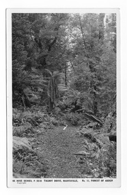
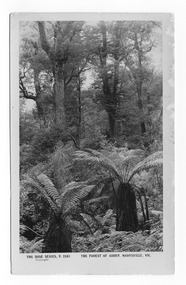
Postcard (item) - Black and white postcard, Rose Stereograph Company, Talbot Drive, Marysville. No. 11, Forest of Arden, 1913-1967
... , Marysville. No. 11, Forest of Arden Postcard Black and white postcard ...A postcard in a series produced by the Rose Stereograph Company in Victoria, Australia as a souvenir of Marysville.A black and white photograph of the Forest of Arden near Marysville in Victoria. This postcard was produced by the Rose Stereograph Company as a souvenir of Marysville.POST CARD THE "ROSE" SERIES/ DE LUXE/ REAL PHOTOS PRODUCED IN/ AUSTRALIA Published by the Rose Stereographs/ Armadale, Victoriaforest of arden, marysville, forest, tree fern, postcard, souvenir, victoria, rose stereograph company, p. 2316 -
 Marysville & District Historical Society
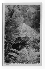
Postcard (item) - Black and white postcard, Rose Stereograph Company, At the Meeting of the Waters, Marysville, Vic, 1913-1967
A postcard in a series produced by the Rose Stereograph Company in Victoria, Australia as a souvenir of Marysville.A black and white photograph of the hut at the Meeting of the Waters near Marysville in Victoria.POST CARD REAL PHOTO THE "ROSE" SERIES DE LUXE PRODUCED IN AUSTRALIA Published by "The Rose Stereographs"/ Armadale, Victoria.meeting of the waters, marysville, victoria, rose series postcard, p. 2336, postcard, souvenir -
 Marysville & District Historical Society
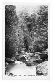
Postcard (item) - Black and white postcard, Rose Stereograph Company, The Taggerty River, Marysville, Victoria, 1913-1967
A postcard in a series produced by the Rose Stereograph Company in Victoria, Australia as a souvenir of Marysville.A black and white photograph of the Taggerty River in Marysville in Victoria.POST CARD The "Rose " Series/ De Luxe A Real Photograph/ Produced in Australia Published by the Rose Stereograph Co.,/ Armadale, Victoriataggerty river, marysville, victoria, p. 2338, rose series postcard, postcard, souvenir -
 Marysville & District Historical Society
Postcard (item) - Black and white postcard, Rose Stereograph Company, The Talbot Drive, Marysville, Victoria, 1913-1967
A postcard in a series produced by the Rose Stereograph Company in Victoria, Australia as a souvenir of Marysville.Lady Talbot Drive (Talbot Drive) is a 24 kilometer scenic rainforest car journey which passes a number of walks and waterfalls in the Yarra Ranges National Park. Lady Talbot Drive is named after Lady Sarah Elizabeth, the wife of Sir Reginald Talbot, who was the Governor of Victoria from 25th April, 1904 to 6th July 1908. This road was originally constructed as a corduroy road (or log road) is a type of road or timber trackway made by placing logs, perpendicular to the direction of the road over a low or swampy area. The result is an improvement over impassable mud or dirt roads, yet rough in the best of conditions and a hazard to horses due to shifting loose logs.POST CARD REAL PHOTO THE "ROSE" SERIES DE LUXE PRODUCED IN AUSTRALIA PUBLISHED BY "THE ROSE STEREOGRAPHS"/ Armadale, Victoria.talbot drive, lady talbot drive, lady talbot forest drive, sir reginald talbot, lady sarah elizabeth talbot, rainforest, marysville, victoria, rose stereograph company, p. 2340, postcard, souvenir, corduroy road -
 Marysville & District Historical Society
Postcard (item) - Black and white postcard, Rose Stereograph Company, The Forest of Arden, Marysville, Vic, 1913-1967
A postcard in a series produced by the Rose Stereograph Company in Victoria, Australia as a souvenir of Marysville.A black and white photograph of the forest known as the Forest of Arden near Marysville in Victoria.POST CARD REAL PHOTO THE "ROSE" SERIES DE LUXE PRODUCED IN AUSTRALIA Published by "The Rose Stereographs"/ Armadale, Victoria.forest of arden, marysville, victoria, rose stereograph company, p. 2341, postcard, souvenir -
 Marysville & District Historical Society
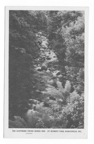
Postcard (item) - Black and white postcard, Rose Stereograph Company, At Murray Pass, Marysville, Vic, 1913-1967
A postcard in a series produced by the Rose Stereograph Company in Victoria, Australia as a souvenir of Marysville.An early black and white photograph of the Taggerty River from Murray Pass near Marysville, Victoria. Murray Pass is located on the Lady Talbot Drive. Lady Talbot Drive a 24 kilometer scenic rainforest car journey which passes a number of walks and waterfalls in the Yarra Ranges National Park. Lady Talbot Drive is named after Lady Sarah Elizabeth, the wife of Sir Reginald Talbot, who was the Governor of Victoria from 25th April, 1904 to 6th July 1908. This postcard was produced by the Rose Stereograph Company as a souvenir of Marysville.POST CARD. Correspondence Addressmarysville, victoria, photograph, taggerty river, murray pass, lady talbot forest drive, southern cross series, 2309, postcard, souvenir, lady talbot drive, sir reginald talbot, sarah elizabeth talbot -
 Marysville & District Historical Society
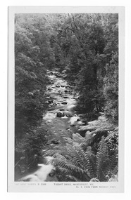
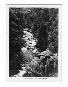
Photograph (item) - Black and white photograph, Rose Stereograph Company, From Murray Pass, Marysville, 1913-1967
An early black and white photograph of the Taggerty River from Murray Pass near Marysville, Victoria.An early black and white photograph of the Taggerty River from Murray Pass near Marysville, Victoria. Murray Pass is off the Lady Talbot Drive. Lady Talbot Drive a 24 kilometer scenic rainforest car journey which passes a number of walks and waterfalls in the Yarra Ranges National Park. Lady Talbot Drive is named after Lady Sarah Elizabeth, the wife of Sir Reginald Talbot, who was the Governor of Victoria from 25th April, 1904 to 6th July 1908.The photograph was also used to produce the Rose Series postcard P. 2309.marysville, victoria, photograph, taggerty river, murray pass, lady talbot forest drive, p. 2309, rose series postcard, souvenir, rose stereograph company, sir reginald talbot, lady sarah elizabeth talbot -
 Marysville & District Historical Society
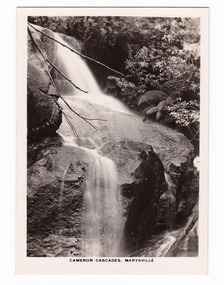
Photograph (item) - Black and white photograph, Rose Stereograph Company, Cameron Cascades, Marysville, 1913-1967
An early black and white photograph of the Cameron Cascades near Marysville, Victoria. An early black and white photograph of the Cameron Cascades near Marysville, Victoria. The Cameron Cascades are off the Lady Talbot Drive. Lady Talbot Drive a 24 kilometer scenic rainforest car journey which passes a number of walks and waterfalls in the Yarra Ranges National Park. Lady Talbot Drive is named after Lady Sarah Elizabeth, the wife of Sir Reginald Talbot, who was the Governor of Victoria from 25th April, 1904 to 6th July 1908. The photograph was also used to produce the Rose Series postcard P. 2313.marysville, victoria, photograph, cameron cascades, waterfalls, cameron cascades track, lady talbot forest drive, p. 2313, rose series postcard, souvenir, rose stereograph company, sir reginald talbot, lady sarah elizabeth talbot -
 Marysville & District Historical Society
Photograph (item) - Colour photograph, 04-1960
A colour photograph of the entrance to a fire dugout on Mount Margaret near Marysville in Victoria.A colour photograph of the entrance to a fire dugout on Mount Margaret near Marysville in Victoria. The fire refuge dugout, which developed in the era of bush sawmilling in the early twentieth century, was a distinctive cultural response to the history of fire in the tall Victorian forests. Few dugouts were built in other forest regions of Australia, but those that did exist in these Victorian ranges saved dozens of lives in the fires of Black Friday 1939.27 'Fire Dug out' Mt Margaret April 1960mount margaret, marysville, victoria, fire dugout, sawmilling industry, black friday 1939, bushfire -
 Marysville & District Historical Society
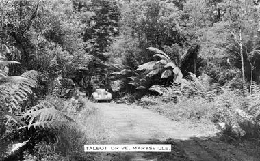
Photograph (item) - Black and white photograph, Talbot Drive, Marysville, Unknown
An early black and white photograph of Lady Talbot Drive in Marysville in Victoria.Lady Talbot Drive a 24 kilometer scenic rainforest car journey which passes a number of walks and waterfalls in the Yarra Ranges National Park. Lady Talbot Drive is named after Lady Sarah Elizabeth, the wife of Sir Reginald Talbot, who was the Governor of Victoria from 25th April, 1904 to 6th July 1908. This road was originally constructed as a corduroy road (or log road) is a type of road or timber trackway made by placing logs, perpendicular to the direction of the road over a low or swampy area. The result is an improvement over impassable mud or dirt roads, yet rough in the best of conditions and a hazard to horses due to shifting loose logs.lady talbot drive, lady talbot forest drive, marysville, victoria, sir reginald talbot, lady sarah elizabeth talbot, corduroy road -
 Marysville & District Historical Society
Photograph (item) - Black and white photograph, Talbot Drive, Marysville, Unknown
An early black and white photograph of Lady Talbot Drive in Marysville in Victoria.An early black and white photograph of a car traveling along Lady Talbot Drive in Marysville in Victoria. Lady Talbot Drive a 24 kilometer scenic rainforest car journey which passes a number of walks and waterfalls in the Yarra Ranges National Park. Lady Talbot Drive is named after Lady Sarah Elizabeth, the wife of Sir Reginald Talbot, who was the Governor of Victoria from 25th April, 1904 to 6th July 1908. This road was originally constructed as a corduroy road (or log road) is a type of road or timber trackway made by placing logs, perpendicular to the direction of the road over a low or swampy area. The result is an improvement over impassable mud or dirt roads, yet rough in the best of conditions and a hazard to horses due to shifting loose logs.marysville, victoria, lady talbot drive, lady talbot forest drive, sir reginald talbot, lady sarah elizabeth talbot, corduroy road -
 Bendigo Military Museum
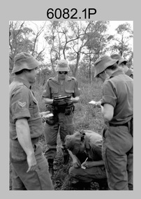
Photograph - Army Survey Regiment - Regimental Training Navigation Exercise, 1985
... personnel undertaking a navigation exercise in the Wellford Forest... at Fortuna; RATEL at Wellsford Forest and rifle shooting at Wellsford ...This is a set of 16 photographs of Army Survey Regiment personnel undertaking a non-tactical navigation exercise, part of the field phase of regimental training in the Wellsford Forest, Bendigo 1985. This was one of the six regimental training objectives outlined in the administrative instruction – Exercise “City Soldier” accompanying these photos. The other objectives were SLR rifle and M30 grenade handling revision, and first aid at Fortuna; RATEL at Wellsford Forest and rifle shooting at Wellsford Rifle Range. Personnel from Air Survey, Cartographic, Lithographic and Headquarters Squadrons were reallocated to four training platoons for one week from 7th to 11th October 1985.This is a set of 16 photographs of Army Survey Regiment personnel undertaking a navigation exercise in the Wellford Forest, Bendigo 1985. Black & white photos .1P to .10P are printed on photographic paper and scanned at 300 dpi. Photos .11P to .16P are on 35mm negative film and scanned at 96 dpi. They are part of the Army Survey Regiment’s Collection. .1) - Photo, black & white, 1985, L to R: CPL Mick Minchin, SGT Alan Staley, CPL Megan (McBurney) Reynolds SPR Wendy (Leitinger) McCarthy. .2) - Photo, black & white, 1985, L to R: unidentified, SPR Wendy (Leitinger) McCarthy, CPL Megan (McBurney) Reynolds, unidentified, SGT Alan Staley, SPR Dave Lawler. .3) - Photo, black & white, 1985, L to R: CPL Greg Honan, CPL Grant McGuinness, SPR Leah (Hoffman) Peppler, CPL Ken Peters, SSGT Ian ‘Rock’ Thistleton, SSGT Kevin ‘Spook’ Kennedy. .4) - Photo, black & white, 1985, unidentified personnel. .5) - Photo, black & white, 1985, L to R: CPL Peter ‘Spoon’ Lefel, unidentified, CPL Mick ‘Buddha’ Ellis. .6) - Photo, black & white, 1985, L to R: SSGT Harald Mai, unidentified. .7) - Photo, black & white, 1985, unidentified personnel. .8) - Photo, black & white, 1985, unidentified personnel. .9) - Photo, black & white, 1985, WO1 Dick Manley. .10) - Photo, black & white, 1985, L to R: LT Brenton MacDonald, LT Kathie Ryan, WO1 Brian Mead. .11) - Photo, black & white, 1985, L to R: LT Carol Dunstan, unidentified, CPL John Reid. .12) - Photo, black & white, 1985, L to R: WO1 Dick Manley, unidentified, LT Carol Dunstan. .13) - Photo, black & white, 1985, L to R: unidentified (x2), WO1 Dick Manley. .14) - Photo, black & white, 1985, LT Brenton McDonald. .15) - Photo, black & white, 1985, L to R: CPL Megan (McBurney) Reynolds, SPR Wendy (Leitinger) McCarthy, CPL Mick Minchin. .16) - Photo, black & white, 1985, L to R: SPR Wendy (Leitinger) McCarthy, CPL Mick Minchin..1P to .16P – No personnel are identified.royal australian survey corps, rasvy, army survey regiment, army svy regt, fortuna, asr -
 Bendigo Military Museum
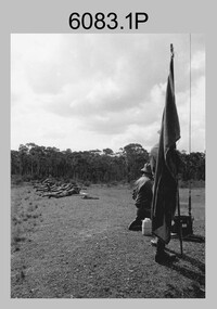
Photograph - Army Survey Regiment - Regimental Training at Wellsford Rifle Range, Bendigo, 1985
This is a set of seven photographs of Army Survey Regiment personnel undertaking live fire SLR rifle qualification training at Wellsford Rifle Range, Bendigo 1985. This was the last of six regimental training objectives outlined in the administrative instruction – Exercise “City Soldier” accompanying these photos. The other objectives were SLR rifle and M30 grenade handling revision, and first aid at Fortuna; and navigation and RATEL at Wellsford Forest. Personnel from Air Survey, Cartographic, Lithographic and Headquarters Squadrons were reallocated to four training platoons for one week from 7th to 11th October 1985. Rifle shooting at Wellsford Rifle Range occurred for two days at the end of the week.This is a set of seven photographs of the Army Survey Regiment undertaking live fire rifle qualification training at Wellsford Rifle Range, Bendigo, 1985. Black & white photos .1P to .5P are printed on photographic paper and scanned at 300 dpi. Photos .6P to .7P are on 35mm negative film and scanned at 96 dpi. They are part of the Army Survey Regiment’s Collection. .1) - Photo, black & white, 1985, unidentified personnel. .2) - Photo, black & white, 1985, unidentified personnel. .3) - Photo, black & white, 1985, unidentified personnel. .4) - Photo, black & white, 1985, MAJ Terry Edward. .5) - Photo, black & white, 1985, unidentified US Army Exchange officer. .6) & .7) - Photo, black & white, 1985, unidentified rifle range safety officer..1P to .7P – No personnel are identifiedroyal australian survey corps, rasvy, army survey regiment, army svy regt, fortuna, asr