Showing 823 items
matching board of works
-
 Greensborough Historical Society
Map, Melbourne and Metropolitan Board of Works. Survey Division, MMBW, Yarra 2500 / 14.23. Diamond Creek, Sutherland Homes, 1979_05
... melbourne and metropolitan board of works...Melbourne and Metropolitan Board of Works. Yarra 2500 [base...Melbourne and Metropolitan Board of Works. Survey Division.... and metropolitan board of works shire of diamond valley plenty - maps ...Melbourne and Metropolitan Board of Works. Yarra 2500 [base map] 14.23. Diamond Creek, Sutherland Homes. Parish of Morang 3183 and Nillumbik 3310. Municipality of Diamond Valley 257. Prominent streets Aqueduct Road, Diamond Creek Road, Yan Yean Road and McLaughlans Lane. Features include the abandoned Maroondah aqueduct and Sutherland Cottages.MMBW Map in 1:2500 [scale] series. Cream parchment with green tape reinforcing on edges and punched holes on left edge.mmbw, melbourne and metropolitan board of works, shire of diamond valley, plenty - maps, sutherland homes, maroondah aqueduct -
 Greensborough Historical Society
Map, Melbourne and Metropolitan Board of Works. Survey Division, MMBW, Yarra 2500 / 13.28. Mernda, Wilton Vale, 1977_08
... melbourne and metropolitan board of works...Melbourne and Metropolitan Board of Works. Yarra 2500 [base...Melbourne and Metropolitan Board of Works. Survey Division.... and metropolitan board of works shire of diamond valley mernda - maps MMBW ...Melbourne and Metropolitan Board of Works. Yarra 2500 [base map] 13.28. Mernda, Wilton Vale. Municipality of Diamond Valley 257 and Whittlesea 239. Prominent streets: Wilton Vale Road. Features include Yan Yean Pipe Track and SEC Transmission Lines. The abandoned rail line (old Whittlesea line) is in the top left corner.MMBW Map in 1:2500 [scale] series. Cream parchment with green tape reinforcing on edges and punched holes on left edge.mmbw, melbourne and metropolitan board of works, shire of diamond valley, mernda - maps -
 Greensborough Historical Society
Map, Melbourne and Metropolitan Board of Works. Survey Division, MMBW, Yarra 2500 / 15.24. Diamond Creek, Grassy Flat Road, 1978_02
... melbourne and metropolitan board of works...Melbourne and Metropolitan Board of Works. Yarra 2500 [base...Melbourne and Metropolitan Board of Works. Survey Division.... and metropolitan board of works diamond creek - maps shire of diamond ...Melbourne and Metropolitan Board of Works. Yarra 2500 [base map] 15.24. Diamond Creek, Grassy Flat Road. Parish of Nillumbik 3310. Municipality of Diamond Valley 257. Prominent streets include: Everleigh Drive, Broad Gully Road and Clyde Street. Features include the Diamond Creek, Nillumbik Park and Diamond Creek Reservoir.MMBW Map in 1:2500 [scale] series. Cream parchment with green tape reinforcing on edges and punched holes on left edge.mmbw, melbourne and metropolitan board of works, diamond creek - maps, shire of diamond valley -
 Port Melbourne Historical & Preservation Society
Plan - Drainage, Board of Works, William Pentland (Coach builders), corner Ingles Street and Crockford Street, 21 Dec 1939
... Drainage, Board of Works, William Pentland (Coach builders...Board of Works drainage plan for William Pentland (coach... environment - industrial sue pentland william pentland Board of Works ...Board of Works drainage plan for William Pentland (coach builders) 1939built environment - industrial, sue pentland, william pentland -
 Eltham District Historical Society Inc
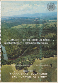
Book, Melbourne Metropolitan Board of Works, Lower Yarra Water Supply DeVelopment: Report on Yarra Brae-Sugarloaf Environmental Study, April 1974
... Melbourne Metropolitan Board of Works...Melbourne Metropolitan Board of Works... melbourne Environmental Study Melbourne Metropolitan Board of Works ...environmental study, melbourne metropolitan board of works, report, sugarloaf reservoir, water catchment area, water supply, yarra brae dam, yarra river valley -
 Eltham District Historical Society Inc
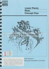
Book, Brett Cheatley et al, Lower Plenty River Concept Plan; Maroondah Pipetrack - Greensborough to Yarra/Plenty Confluence; Draft Volume B, Resource Description and Issues, February 1991
... Melbourne Metropolitan Board of Works...Melbourne and Metropolitan Board of Works (Vic.). Open... melbourne Concept Plan Melbourne Metropolitan Board of Works Plenty ...concept plan, melbourne metropolitan board of works, plenty river, report -
 Greensborough Historical Society
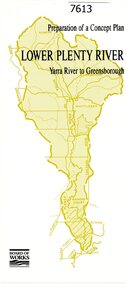
Pamphlet, Melbourne & Metropolitan Board of Works, Lower Plenty River: Yarra River to Greensborough: preparation of a concept plan, 1990
... board of works...Melbourne & Metropolitan Board of Works.... plenty river melbourne water corporation board of works 2 p ...This pamphlet outlines a proposed concept plan for the lower Plenty River, Greensborough to Heidelberg. The plan would focus on preserving and enhancing the aesthetic, recreational and conservation potential of the waterway.2 p., illus., tri-fold pamphlet. 2 copiesplenty river, melbourne water corporation, board of works -
 Greensborough Historical Society
Map, Melbourne and Metropolitan Board of Works. Survey Division, MMBW, Yarra 2500 / 13.19. Lower Plenty, Montmorency, Yallambie, 1979_02
... melbourne and metropolitan board of works...Melbourne and Metropolitan Board of Works. Yarra 2500 [base...Melbourne and Metropolitan Board of Works. Survey Division.... and metropolitan board of works shire of diamond valley montmorency - maps ...Melbourne and Metropolitan Board of Works. Yarra 2500 [base map] 13-19. Lower Plenty, Montmorency, Yallambie. Parishes of Keelbundora 2856 and Nillumbik 3310. Municipalities of Heidelberg 228, Diamond Valley 257 and Eltham 238. Prominent streets include: Elder Street, Para Road, and Main Road Lower Plenty. Includes Watsonia Army Barracks.MMBW Map in 1:2500 [scale] series. Cream parchment with green tape reinforcing on edges and punched holes on left edge.mmbw, melbourne and metropolitan board of works, shire of diamond valley, montmorency - maps, yallambie - maps, lower plenty - maps -
 Kew Historical Society Inc
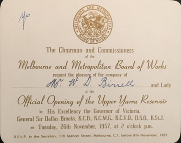
Document (item) - Invitation to the Official Opening of the Upper Yarra Reservoir, Melbourne and Metropolitan Board of Works, 1957
... melbourne & metropolitan board of works... AND METROPOLITAN BOARD OF WORKS / REQUEST THE / PLEASURE OF THE COMPANY...Melbourne and Metropolitan Board of Works... invitations -- kew (vic) melbourne & metropolitan board of works upper ...The Municipality of Kew (1860-1863), the Borough of Kew (1863-1910), the Town of Kew (1910-1921) and the City of Kew (1921-1994) were local government instrumentalities in the State of Victoria. In 1994, the City of Kew was amalgamated, together with the former Cities of Camberwell and Hawthorn, into the new City of Boroondara (1994- ). Like other local government entities of the period, Kew was administered by town clerks. The two notable town clerks in Kew's history were H. H. (Henry Hirst) Harrison (1868-1955) and W. D. (William Dickie) Birrell (1899-1974). Harrison was appointed to the position in 1901 and retired in 1938 after 37 years. Birrell, appointed Acting Town Clerk in 1921, became Town Clerk in 1938, following Harrison's retirement. He continued in this role until his retirement in 1966.This card is part of an historically significant civic collection, containing hundreds of separate invitations, documents, greeting cards, programmes and tickets issued and/or collected by successive town clerks. Items in the collection illuminate the political, social and cultural history of the district. As a continuous record, ranging across most decades of the Twentieth Century, they reveal changing tastes in design, values and relationships in the history of local government in Victoria.THE CHAIRMEN AND COMMISSIONERS / OF THE MELBOURNE AND METROPOLITAN BOARD OF WORKS / REQUEST THE / PLEASURE OF THE COMPANY OF / Mr W D Birrell / AT THE / OPENING OF THE UPPER YARRA RESERVOIR / BY HIS EXCELLENCY THE GOVERNOR OF VICTORIA / GENERAL SIR DALLAS BROOKS KCB KCMG KCVO DSO KStJ / ON TUESDAY, 26TH NOVEMBER, 1957, AT 2 O'CLOCK P.M. / RSVP TO THE SECRETARY, 110 SPENCER STREET, MELBOURNE, C1, BEFORE 8TH NOVEMBER, 1957civic invitations -- kew (vic), melbourne & metropolitan board of works, upper yarra reservoir -
 Greensborough Historical Society
Map, Melbourne and Metropolitan Board of Works. Survey Division, MMBW, Yarra 2500 / 14.22. St Helena, St Katherine's Church, 1979_08
... melbourne and metropolitan board of works...Melbourne and Metropolitan Board of Works. Yarra 2500 [base...Melbourne and Metropolitan Board of Works. Survey Division.... and metropolitan board of works shire of diamond valley st helena - maps st ...Melbourne and Metropolitan Board of Works. Yarra 2500 [base map] 14.22. St Helena, St Katherine's Church. Parish of Nillumbik 3310. Municipality of Diamond Valley 257. Prominent streets St Helena Road, Weidlich Road, Yan Yean Road and Allumba Drive. Features include St Katherine's Church of England and the St Helena Secondary College site.MMBW Map in 1:2500 [scale] series. Cream parchment with green tape reinforcing on edges and punched holes on left edge.mmbw, melbourne and metropolitan board of works, shire of diamond valley, st helena - maps, st katherines church st helena -
 Greensborough Historical Society
Map, Melbourne and Metropolitan Board of Works. Survey Division, MMBW, Yarra 2500 / 12.24. Plenty and Blue Lake, 1977_10
... melbourne and metropolitan board of works...Melbourne and Metropolitan Board of Works. Yarra 2500 [base...Melbourne and Metropolitan Board of Works. Survey Division.... and metropolitan board of works shire of diamond valley plenty - maps blue ...Melbourne and Metropolitan Board of Works. Yarra 2500 [base map]. 12-24, Municipalities of Whittlesea 239 and Diamond Valley 257. Shows street names, easement sizes, lot numbers, lodged plan numbers, names of prominent features, contour values, creek or river names. Watsonia Railway Station and environs. Prominent streets: Memorial Drive. Includes Plenty River and Blue Lake in the Plenty Gorge.MMBW Map in 1:2500 [scale] series. Cream parchment with green tape reinforcing on edges and punched holes on left edge.mmbw, melbourne and metropolitan board of works, shire of diamond valley, plenty - maps, blue lake -
 Greensborough Historical Society
Map, Melbourne and Metropolitan Board of Works. Survey Division, MMBW, Yarra 2500 / 13.21. Central Greensborough, 1979_05
... melbourne and metropolitan board of works...Melbourne and Metropolitan Board of Works. Yarra 2500 [base...Melbourne and Metropolitan Board of Works. Survey Division.... melbourne and metropolitan board of works shire of diamond valley ...Melbourne and Metropolitan Board of Works. Yarra 2500 [base map]. 13-21, Parishes of Keelbundora 2856 and Nillumbik 3310, Municipality of Diamond Valley 257. Shows street names, easement sizes, lot numbers, lodged plan numbers, names of prominent features, contour values, creek or river names. Central Greensborough. Prominent streets: Main Street, Para Road, St Helena Road and Diamond Creek Road.MMBW Map in 1:2500 [scale] series. Cream parchment with green tape reinforcing on edges and punched holes on left edge.mmbw, melbourne and metropolitan board of works, shire of diamond valley, greensborough - maps -
 Greensborough Historical Society
Map, Melbourne and Metropolitan Board of Works. Survey Division, MMBW, Yarra 2500 / 12.19. Watsonia, Simpson Army Barracks, 1983_03
... melbourne and metropolitan board of works...Melbourne and Metropolitan Board of Works. Yarra 2500 [base...Melbourne and Metropolitan Board of Works. Survey Division.... melbourne and metropolitan board of works shire of diamond valley ...Melbourne and Metropolitan Board of Works. Yarra 2500 [base map]. 12-19, Parish of Keelbundora 2856, Municipalities of Diamond Valley 257 and 228. Shows street names, easement sizes, lot numbers, lodged plan numbers, names of prominent features, contour values, creek or river names. Watsonia Barracks (Simpson Army Barracks) and environs. Prominent streets: Yallambie Road, Greensborough Road, and Strathallan Road. MMBW Map in 1:2500 [scale] series. Cream parchment with green tape reinforcing on edges and punched holes on left edge.mmbw, melbourne and metropolitan board of works, shire of diamond valley, watsonia - maps -
 Greensborough Historical Society
Map, Melbourne and Metropolitan Board of Works. Survey Division, MMBW, Yarra 2500 / 13.22. Greensborough, Apollo Parkways, 1979_06
... melbourne and metropolitan board of works...Melbourne and Metropolitan Board of Works. Yarra 2500 [base...Melbourne and Metropolitan Board of Works. Survey Division.... (Bypass) mmbw melbourne and metropolitan board of works shire ...Melbourne and Metropolitan Board of Works. Yarra 2500 [base map] 13-22. Greensborough, Apollo Parkways. Parishes of Nillumbik 3310 and Keelbundora 2856. Municipalities of Diamond Valley 257 and Whittlesea 239. Prominent streets include: Plenty River Drive, Diamond Creek Road and Civic Drive. Includes Diamond Valley Civi Centre, Churinga, Janefield Colony Reserve and "proposed freeway" now Greensborough Highway (Bypass)MMBW Map in 1:2500 [scale] series. Cream parchment with green tape reinforcing on edges and punched holes on left edge.mmbw, melbourne and metropolitan board of works, shire of diamond valley, greensborough - maps, apollo parkways - maps -
 Bayside Gallery - Bayside City Council Art & Heritage Collection
Map - print, Melbourne and Metropolitan Board of Works, Interim development order: Brighton, Moorabbin and Sandringham, 1959
... Melbourne and Metropolitan Board of Works...The Melbourne and Metropolitan Board of Works (now...Melbourne and Metropolitan Board of Works... The Melbourne and Metropolitan Board of Works (now Melbourne Water ...The Melbourne and Metropolitan Board of Works (now Melbourne Water) was established in 1891. From that time, as part of their work laying water and sewerage connections, they created detailed plans of houses and other buildings in the Melbourne metropolitan area. In 1956 it acquired powers to construct and maintain highways and bridges, protect and improve the foreshores and create and maintain parks within the metropolitan region. This Interim development order comprises part of the municipalities of Brighton, Moorabbin and Sandringham and was made on 20 October 1959.brighton, moorabbin, sandringham, melbourne and metropolitan board of works, map, town planning, cartographic material, interim development order, bayside -
 Greensborough Historical Society
Map, Melbourne and Metropolitan Board of Works. Survey Division, MMBW, Yarra 2500 / 12.20. Watsonia Railway Station and environs, 1983_03
... melbourne and metropolitan board of works...Melbourne and Metropolitan Board of Works. Yarra 2500 [base...Melbourne and Metropolitan Board of Works. Survey Division.... and Metropolitan Board of Works. Survey Division. ...Melbourne and Metropolitan Board of Works. Yarra 2500 [base map]. 12-20, Parishes of Keelbundora 2856, Municipalities of Diamond Valley 257 and 228. Shows street names, easement sizes, lot numbers, lodged plan numbers, names of prominent features, contour values, creek or river names. Watsonia Railway Station and environs. Prominent streets: Watsonia Road, Elder Street, Morwell Avenue and Nepean Street. Includes former Watsonia Technical School and Gresswell Rehabilitation Centre sites.MMBW Map in 1:2500 [scale] series. Cream parchment with green tape reinforcing on edges and punched holes on left edge.mmbw, melbourne and metropolitan board of works, shire of diamond valley, watsonia - maps -
 Greensborough Historical Society
Map, Melbourne and Metropolitan Board of Works. Survey Division, MMBW, Yarra 2500 / 12.21. Watsonia North, 1979_02
... melbourne and metropolitan board of works...Melbourne and Metropolitan Board of Works. Yarra 2500 [base...Melbourne and Metropolitan Board of Works. Survey Division.... and metropolitan board of works shire of diamond valley watsonia - maps ...Melbourne and Metropolitan Board of Works. Yarra 2500 [base map]. 12-22, Parish of Keelbundora 2856, Municipality of Diamond Valley 257. Shows street names, easement sizes, lot numbers, lodged plan numbers, names of prominent features, contour values, creek or river names. Watsonia Railway Station and environs. Prominent streets: Grimshaw Street, William Street and Macorna Street. Includes former Institute of Social Welfare (now Loyola College) Lines Reserve and Binnak Park.MMBW Map in 1:2500 [scale] series. Cream parchment with green tape reinforcing on edges and punched holes on left edge.mmbw, melbourne and metropolitan board of works, shire of diamond valley, watsonia - maps, bundoora - maps -
 Greensborough Historical Society
Map, Melbourne and Metropolitan Board of Works. Survey Division, MMBW, Yarra 2500 / 12.22. Watsonia North, 1978_03
... melbourne and metropolitan board of works...Melbourne and Metropolitan Board of Works. Yarra 2500 [base...Melbourne and Metropolitan Board of Works. Survey Division.... melbourne and metropolitan board of works shire of diamond valley ...Melbourne and Metropolitan Board of Works. Yarra 2500 [base map]. 12-22, Parishes of Keelbundora 2856, Municipalities of Whittlesea 239 and Diamond Valley 257. Shows street names, easement sizes, lot numbers, lodged plan numbers, names of prominent features, contour values, creek or river names. Watsonia Railway Station and environs. Prominent streets: Edmund Rice Parade and Macorna Street. Includes Christian Brothers Edmund Rice College and Janefield Special School sites and "proposed future freeway" (now Metropolitan Ring Road).MMBW Map in 1:2500 [scale] series. Cream parchment with green tape reinforcing on edges and punched holes on left edge.mmbw, melbourne and metropolitan board of works, shire of diamond valley, watsonia - maps, bundoora - maps -
 Kew Historical Society Inc
Plan, Melbourne and Metropolitan Board of Works, Borough of Kew : Detail Plan No.1580, 1904
... melbourne and metropolitan board of works, detail plans...The Melbourne and Metropolitan Board of Works (MMBW) plans...Melbourne and Metropolitan Board of Works... The Melbourne and Metropolitan Board of Works (MMBW) plans were produced ...The Melbourne and Metropolitan Board of Works (MMBW) plans were produced from the 1890s to the 1950s. They were crucial to the design and development of Melbourne's sewerage and drainage system. The plans, at a scale of 40 feet to 1 inch (1:480), provide a detailed historical record of Melbourne streetscapes and environmental features. Each plan covers one or two street blocks (roughly six streets), showing details of buildings, including garden layouts and ownership boundaries, and features such as laneways, drains, bridges, parks, municipal boundaries and other prominent landmarks as they existed at the time each plan was produced. (Source: State Library of Victoria)This plan forms part of a large group of MMBW plans and maps that was donated to the Society by the Mr Poulter, City Engineer of the City of Kew in 1989. Within this collection, thirty-five hand-coloured plans, backed with linen, are of statewide significance as they include annotations that provide details of construction materials used in buildings in the first decade of the 20th century as well as additional information about land ownership and usage. The copies in the Public Record Office Victoria and the State Library of Victoria are monochrome versions which do not denote building materials so that the maps in this collection are invaluable and unique tools for researchers and heritage consultants. A number of the plans are not held in the collection of the State Library of Victoria so they have the additional attribute of rarity.Original survey plan, issued by the MMBW to a contractor with responsibility for constructing sewers in the area identified on the plan within the Borough of Kew. The plan was at some stage hand-coloured, possibly by the contractor, but more likely by officers working in the Engineering Department of the Borough and later Town, then City of Kew. The hand-coloured sections of buildings on the plan were used to denote masonry or brick constructions (pink), weatherboard constructions (yellow), and public buildings (grey). The area represented in this detail plan has undergone significant change during the 20th century. The widening of High Street in the 1930s and 1950s involved the shops on the south side of High Street being demolished and later rebuilt to fit the widened street. Another significant loss was the mansion ‘Drayton’ fronting Wellington Street, owned at this stage by Susannah Fenton. Her family name would later to be given to Fenton Way, which was to be built over the grounds of the house following its demolition. The plan of the garden is particularly interesting, containing a batten dome fronting Wellington Street, an ornamental pond, a fountain and a brick and glass conservatory. The notes by the plumbing contractor on this plan are particularly detailed. Pink borders delineate the ownership of the varying parcels of land. Some of the better known owners listed include the real estate agent Cr. Henry de Castres Kellett (bt) and John Padbury, the funeral director. This particular plan provides a clear view of the configuration of the Kew Junction in 1903 and the commercial buildings that surrounded it.melbourne and metropolitan board of works, detail plans, maps - borough of kew, mmbw 1580, cartography -
 Kew Historical Society Inc
Plan, Melbourne and Metropolitan Board of Works, Borough of Kew : Detail Plan No.1562, 1905
... melbourne and metropolitan board of works, detail plans...The Melbourne and Metropolitan Board of Works (MMBW) plans...Melbourne and Metropolitan Board of Works... The Melbourne and Metropolitan Board of Works (MMBW) plans were produced ...The Melbourne and Metropolitan Board of Works (MMBW) plans were produced from the 1890s to the 1950s. They were crucial to the design and development of Melbourne's sewerage and drainage system. The plans, at a scale of 40 feet to 1 inch (1:480), provide a detailed historical record of Melbourne streetscapes and environmental features. Each plan covers one or two street blocks (roughly six streets), showing details of buildings, including garden layouts and ownership boundaries, and features such as laneways, drains, bridges, parks, municipal boundaries and other prominent landmarks as they existed at the time each plan was produced. (Source: State Library of Victoria). This plan forms part of a large group of MMBW plans and maps that was donated to the Society by the Mr Poulter, City Engineer of the City of Kew in 1989. Within this collection, thirty-five hand-coloured plans, backed with linen, are of statewide significance as they include annotations that provide details of construction materials used in buildings in the first decade of the 20th century as well as additional information about land ownership and usage. The copies in the Public Record Office Victoria and the State Library of Victoria are monochrome versions which do not denote building materials so that the maps in this collection are invaluable and unique tools for researchers and heritage consultants. A number of the plans are not held in the collection of the State Library of Victoria so they have the additional attribute of rarity.Original survey plan, issued by the MMBW to a contractor with responsibility for constructing sewers in the area identified on the plan within the Borough of Kew. The plan was at some stage hand-coloured, possibly by the contractor, but more likely by officers working in the Engineering Department of the Borough and later Town, then City of Kew. The hand-coloured sections of buildings on the plan were used to denote masonry or brick constructions (pink), weatherboard constructions (yellow), and public buildings (grey). MMBW detail plan No.1562, in contrast to No.1561 includes the names of a large number of houses: in Barkers Road: ‘Ashwick’, ‘Owasso’, ‘Anadiha’, ‘Eurobin’, ‘Carlsruhe’, ‘Arlington’ and ‘Altyre’. Unnamed but clearly represented on the plan is what was then known as the ‘Auburn Heights Recreation Club’, which at this stage included a Bowling Green, a Croquet Green and two Tennis Courts. On the plan, Brougham Place, as it was then known, is represented. It was later renamed Daniell Place. The aforementioned Arlington is now the junior campus of Preshil. melbourne and metropolitan board of works, detail plans, mmbw 1562, cartography -
Port Melbourne Historical & Preservation Society
Plan - Drainage, Board of Works, William Pentland (Coach builders), corner Ingles Street and Crockford Street, 8 Mar 1905
... Drainage, Board of Works, William Pentland (Coach builders...Board of Works drainage plan for William Pentland (Coach... environment - industrial sue pentland william pentland Board of Works ...Board of Works drainage plan for William Pentland (Coach builders) at Ingles St and Crockford St corner. 1905built environment - industrial, sue pentland, william pentland -
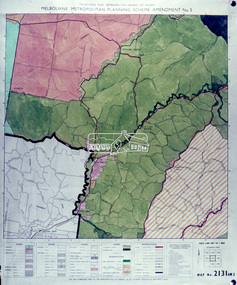
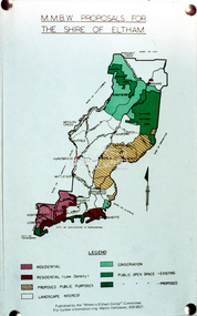 Eltham District Historical Society Inc
Slide - Photograph, Eltham Shire Council, Shire of Eltham, Melbourne Metropolitan Planning Scheme, Amendment No. 3, Melbourne and Metropolitan Board of Works, Apr 1972
... , Amendment No. 3, Melbourne and Metropolitan Board of Works...Melbourne Metropolitan Board of Works... melbourne Map Melbourne Metropolitan Board of Works MMBW Planning ...35mm colour positive transparency blue Agfacolour Service plastic mountmap, melbourne metropolitan board of works, mmbw, planning proposals, shire of eltham, planning -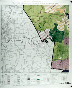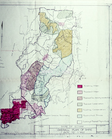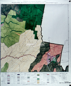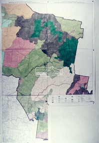
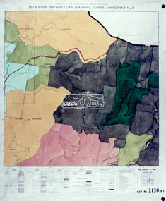
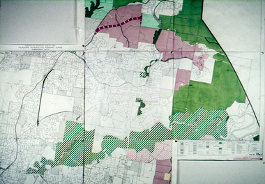 Eltham District Historical Society Inc
Slide - Photograph, Eltham Shire Council, Shire of Eltham, Melbourne Metropolitan Planning Scheme, Amendment No. 21, Melbourne and Metropolitan Board of Works, Apr 1972
... , Amendment No. 21, Melbourne and Metropolitan Board of Works...Melbourne Metropolitan Board of Works... melbourne Map Melbourne Metropolitan Board of Works MMBW Planning ...35mm colour positive transparency blue Agfacolour Service plastic mountmap, melbourne metropolitan board of works, mmbw, planning proposals, shire of eltham, planning