Showing 1057 items matching "boundaries"
-
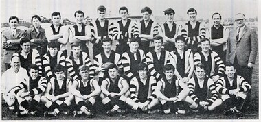 St Patrick's Old Collegians Association (SPOCA)
Photograph - SPOCA, Patricians FC
-
 Port Melbourne Historical & Preservation Society
Photograph - Bay and Boundary Hotel, Bay Street, Port Melbourne, Ron Laing, 1990s
Part of Ron Laing's collection of photographs recording Port Melbourne over a thirteen year period. Donated to the PMH&PS by the photographer.From a group of Ron Laing photographs of Port Melbourne hotels, 1990s: the Bay & Boundary (originally the Rising Sun)business and traders - hotels, ron laing, bay and boundary hotel -
 Flagstaff Hill Maritime Museum and Village
Photograph - Historical, Flagstaff Hill, John Lindsay, View of the Bay from the south boundary of the Ports and Harbours land, 1970s
The photograph shows the view of the shore and Lady Bay with the Breakwater and Middle Island all visible. It was taken to show that the Flagstaff Hill area was unlikely to have any further development between it and the Bay, with the view of development of the Flagstaff Hill Maritime Museum and Village. This photograph, a print, is one of a set of five that show the site of Flagstaff Hill. The photographer was John Lindsay, Founding Director of Flagstaff Hill Maritime Museum and Village, with the words "Photo J Lindsay" on the back. It was taken in the early 1970s during the initial stages of the development of Flagstaff Hill as a Museum and Maritime Village. The photographs belonged to the donor's grandparents, who lived in the Warrnambool district of Allansford/Naringal. The photograph is a record of the site and surrounds of Flagstaff Hill Maritime Museum and Village before its development and opening in 1975. It shows the Surfside Holiday Park, Surf Lifesaving Club, and the Breakwater. The photograph is significant for recording the location and condition of the Lower Lighthouse on the Hill.Coloured photograph, glassy print, one of a set of five. Flagstaff Hill's Lower Lighthouse is in the foreground above the Surfside Holiday Park. To the right of centre is the Surf Lifesaving Club. In the background is Lady Bay and the Breakwater and Middle Island, with the Southern Ocean the other side. The photograph's paper has the printer's watermark and a pencilled inscription on the back. The early 1970s scene was photographed by John Lindsay, Warrnambool.Label on the back: "VIEW OF THE BAY FROM the southern boundary of the Ports and Harbours land. No development below this area is likely to obstruct the view, due to the steep grade down to the Southern boundary of Flagstaff Hill property." Handwritten in pencil: "Photo J Lindsay"flagstaff hill, flagstaff hill maritime museum and village, warrnambool, maritime museum, maritime village, great ocean road, shipwreck coast, 1970s, photograph, surfside holiday park, lady bay, flagstaff hill site, john lindsay, lower lighthouse, lower light, surf lifesaving club, breakwater, middle island, ports and harbours -
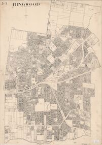 Ringwood and District Historical Society
Map, City of Ringwood - Rateable Properties Layout - c.1966
A0-size (approx) map of named streets, lot-numbered properties and locality features within City of Ringwood boundary. Scale: 8 chains to 1 inch. City Engineer's signature in bottom right corner - Alan Robertson (City Engineer 1958-1987) -
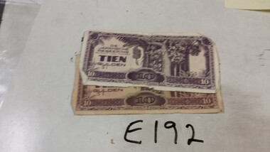 Running Rabbits Military Museum operated by the Upwey Belgrave RSL Sub Branch
Invasion Money
Japanese |Invasion money for Dutch East Indies !0 Guilder X2 (one with Japanese & English) hand writing on boundary.ephemera, ww2, general -
Port Melbourne Historical & Preservation Society
Document - Newsletters, Council activities, Cr Glen Cosham, Glen Cosham, 1974 - 1978
Retained by donor from his service on Port Melbourne Council from 1973 to 1978.13 bulletins on Council activities, sent to Boundary Ward residents by then Councillor Glen Cosham between 1974 and 1978 (photocopies)local government - city of port melbourne, glen cosham -
Clunes Museum
Document - NEWSPAPER, THE BALLARAT NEWS, THE NEWS 1/8/1991, 1/8/1991
THE NEWS, 1 AUGUST 1991. REAL ESTATE NEWS, COUNTRY CABIN AT CLUNES. NO. 1 BOUNDARY ROAD ON 4.05 HECTARESreal estate, 1 boundary road -
 Whitehorse Historical Society Inc.
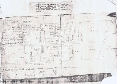
Document, South Riding
Plan showing owners of land in the South Riding of the Shire of NunawadingPlan showing owners of land in the South Riding of the Shire of Nunawading 1888. South Boundary Road is now Highbury RoadPlan showing owners of land in the South Riding of the Shire of Nunawading land subdivision, shire of nunawading. centre riding, dandenong creek, fulton, dr, shire of nunawading. south riding, arundale, w, h. arnold & co. -
 Whitehorse Historical Society Inc.
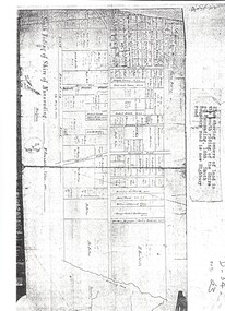
Map, Shire of Nunawading 1888
Plan showing owners of land in the South Riding of the Shire of Nunawading, 1888. South Boundary Road is now Highbury Road.shire of nunawading. south riding, south boundary road, burwood east, highbury road, springvale road, mahoneys road, forest hill, holland road, blackburn south, burwood highway -
 Bendigo Military Museum
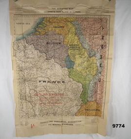
Map - ARMISTICE MAP, WW1, The Industrial Australian and Mining Standard, Melbourne and Sydney>, Post June 1919
The different colours cover France, Belgium, Luxembourg, Alsace, Lorraine, The Rhine, Nuetral zone, Germany, Switzerland, Holland, Rhenish Prussia (Germany) Item in the collection relating to C.J.C. McQuie MM, refer Cat No 9680P for his service details.Map in colour showing a large section of Europe, the boundaries set up after the Armistice in 1919, countries are in different colours.At the top, "The Armistice map, Germany's new place in Europe"maps, europe, armistice, mcquie -
 Bendigo Historical Society Inc.
Map - EPSOM ?, Circa 1880
Map: Parish plan showing an area Southwards from the parish of Huntly boundary, Covering Epsom,Ascot and White Hillsmap, bendigo, parish plan, epsom, ascot, white hills -
Whitehorse Historical Society Inc.
Document, History of Tally Ho Boys Home, 1972
Three papers on History of Boys Training Farm, Highbury Road, Tally Ho3 papers on History of Boys Training Farm, Highbury Road, Tally Ho, commenced in 1903 by Rev. and Mrs George Cole. The story covers the period from 1903-1930. The farm was built on land bought from Abel Hoadley for 1,000 Pounds near the corner of Springvale Road in Boundary Road (now Highbury Road). 2 letters (16/7/1972 & 28/5/1972) to Nancy Leach from E. Hinneberg, Assistant Superintendent, Tally Ho, about his association with Tally Ho.Three papers on History of Boys Training Farm, Highbury Road, Tally Hoyouth services, tally ho boys home, cole, george, rev., cole, mrs, hoadley, abel, boundary road burwood east, highbury road, burwood east, springvale road, burwood east, leach, nancy, hinneberg, ernest. -
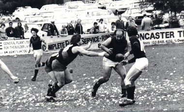 Emerald Museum & Nobelius Heritage Park
B/W Photograph, Emerald v Powelltown Grand Final 1983, 1983
Emerald Football Club won the Premiership in 1983 against Powelltown.The photograph records a significant even in the history of the Emerald Football Club.B/W photograph of several footballers grappling for the ball, near the oval boundary. A dozen or so spectator clearly visible in the background.Rear (handwritten): "1983" (top right corner) "Peter Rush - No. 18 front left" "Emerald Football Club playing Powelltown" "Grand Final - Emerald won"emerald football club, powelltown football club -
Port Melbourne Historical & Preservation Society
Document - Specification, Tramway, Normanby Road, Ingles Street to Boundary Street, Port Melbourne, 14 Mar 1893
Written specification for works attached to plan of tramway in Normanby Road from Ingles Street to Boundary Street (Reg 66.1), 1893.A.V. Heath (Town Surveyor) J.J. Bartlett (Mayor)engineering - roads streets lanes and footpaths, transport - tramways, town planning, town clerks, mayors, arthur victor heath, james john bartlett -
Port Melbourne Historical & Preservation Society
Map - Footscray, Public Lands Office, 19 Oct 1857
Map of Footscray, west of Saltwater Creek; south of Hopkins Street, east of Railway and north southern boundary of Botanical Garden reserve.The Township of Footscray, Parish of Cut-Paw-Pawfootscray -
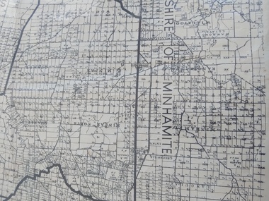 Peterborough History Group
Map - Shire of Warrnambool
Map of the area, when Peterborough was part of Warrnambool ShireHistoric map of the area when Peterborough was in the Warrnambool ShireA3 size map, larger view of the whole shire of Warrnambool, and includes adjoining Shire Boundaries. Shows individual land allotments.peterborough, warrnambool shire, old maps -
Whitehorse Historical Society Inc.
Article, Reins to city, 1995
Whitehorse Council's Chief Executive Office, Dr Shirley Randall and Chief Commissioner, Geoff Oscar inspect the new boundary signs.Whitehorse Council's Chief Executive Office, Dr Shirley Randall and Chief Commissioner, Geoff Oscar inspect the new boundary signs.Whitehorse Council's Chief Executive Office, Dr Shirley Randall and Chief Commissioner, Geoff Oscar inspect the new boundary signs.city of whitehorse, logos, randell, shirley, oscar, geoff -
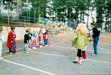 Sunbury Family History and Heritage Society Inc.
Photograph, Bulla Primary School - Dress-up Day, C1993
The children in photograph are not wearing their school uniform as it was taken on a Bulla Primary School dress-up day. Although they didn't wear their uniforms, classes carried on as normal. This young group are practising ball handling skills needed for netball. he teacher with her back to the camera is Barbara Springfield. A coloured photograph showing eight children standing on the boundary of a netball court with two adults, who are playing a ball game with the children.bulla primary school dress-up day, barbara springfield, ball games -
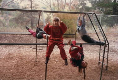 Sunbury Family History and Heritage Society Inc.
Photograph, Bulla Primary School - Playground, c 1994
In the early 1990s a number of upgrades and improvements were made to the buildings and the playground at the Bulla Primary School. The climbing frame which these children are using was one of the items installed in the school's playground.A coloured pre-digital photograph of four children playing on a climbing frame in a playground. There are trees growing behind the boundary cyclone fence.playground equipment, bulla primary school, climbing frame -
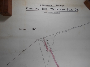 Bendigo Historical Society Inc.
Administrative record - Central Red White and Blue
Draftsman's drawing Boundary Survey Central Red White and Blue Map Forms part of the Margaret Roberts Collection of mining records.bendigo, margaret roberts, gold, map, mine, central red white and blue -
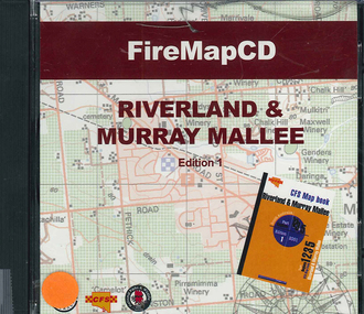 Victorian Aboriginal Corporation for Languages
CD-ROM, Country Fire Services South Australia, FireMapCD Riverland &? Murray Mallee, 2001
The area covered by this map is the same as the CFS Riverland & Murray Mallee Map Book. The area covered adjoins the Mount Lofty Ranges map book on the eastern boundary at Murray Bridge, north to Morgan and east to Renmark and the State Border. It extends southwards to join the northern boundary of the Lower South East map book at Padthaway.CD-ROMfire protection, victorian maps -
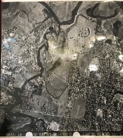 Greensborough Historical Society
Aerial Photograph, Yan Yean M/S 7922 Run 17 No. 3833-18, 1/11/1984
Covers Viewbank area: North boundary Martin's Lane; South boundary Yarra River & Birrarung Park; East boundary east of Plenty RiverLaminated black and white aerial photograph; adjoins 6227 on west sideviewbank -
Port Melbourne Historical & Preservation Society
Plan - Tramway, Normanby Road, Ingles Street to Boundary Street, Port Melbourne, 14 Mar 1893
Plan of tramway in Normanby Road from Ingles Street to Boundary Street, together with written specification for works attached (Reg 66.2), 1893.A.V. Heath (Town Surveyor) J.J. Bartlett (Mayor)engineering - roads streets lanes and footpaths, transport - tramways, town planning, town clerks, mayors, arthur victor heath, james john bartlett -
Port Melbourne Historical & Preservation Society
Flyer - Campaign Leaflets, 1974 Port Melbourne Council Election, 1974
Campaign leaflets for 1974 Port Melbourne Council, Boundary Ward Election .01 - Michael Barbieri, independent .02 - Phillip Lang, ALPlocal government - city of port melbourne, politics, societies clubs unions and other organisations, michael barbieri, phil lang, alp, australian labor party -
 Whitehorse Historical Society Inc.
Article, Dempsey's Boundary Hotel, 1873
An article about Dempsey's Boundary Hotel, NW. cnr Highbury & Middleborough Roads, East Burwood.An article about Dempsey's Boundary Hotel, NW. cnr Highbury & Middleborough Roads, East Burwood. Licensees Mary Anne & William Dempsey.An article about Dempsey's Boundary Hotel, NW. cnr Highbury & Middleborough Roads, East Burwood. dempsey, william, boundary hotel, green mount, dempsey, mary ann, parish of nunawading -
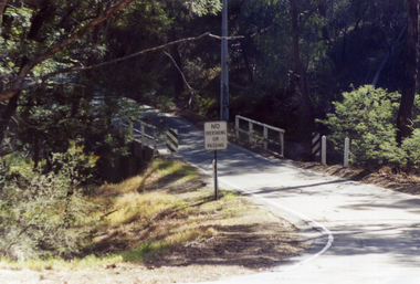 Whitehorse Historical Society Inc.
Photograph, Quarry Road Bridge, Mitcham, 2007
Coloured Photo of Quarry Road Bridge, Mitcham near boundary of Whitehorse Road and Manningham Municipalities. (See record number NP3411 above)quarry road, mitcham, bridges -
Camberwell Historical Society
Pamphlet (Item), City of Boroondara
boroondara, camberwell -
 Whitehorse Historical Society Inc.
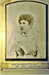
Photograph - B/W Photograph, Alice Schwerkolt
Alice Tanner nee Schwerkolt was the granddaughter of August & Paulina Schwerkolt. She was the child of Louis Schwerkolt and Francisca (Both) Kruse who was the daughter of August's second wife, Wilhelmina. In 1913 Alice married William Martyn Tanner. Marriage Certificate No. 3604.Sepia photograph of a young woman wiith short curly hair and wearing a frilly blouse. The photograph has a frame within its boundary.Alice Schwerkolt Tanner 1891 - 1954. Child of Cissie.schwerkolt alice bertha, tanner alice bertha -
 Greensborough Historical Society
Aerial Photograph, AAM Photographics, Heidelberg AAM1969c 088, 24/11/1991
One of a series of overlapping aerial photographs of the Heidelberg/Greensborough area, covering Eaglemont, Heidelberg, Ivanhoe East & Viewbank. North boundary Hurstbridge railway, South boundary Ivanhoe East, East boundary Bulleen RoadLaminated colour aerial photographeaglemont, heidelberg, ivanhoe east, viewbank -
 Greensborough Historical Society
Map, Municipality of Heidelberg Plan No. 480, 17/10/1948
Map shows streets, buildings, river and major drainage easements in area covered by West boundary Sellars Street, North boundary Yando Street & South boundary Grimshaw Street. Adjoins Map No. 481 to East. Black & white map, features marked in green, gradients in red. Scale: 160 feet to 1 inchgreensborough