Showing 234 items
matching box hill council
-
 Whitehorse Historical Society Inc.
Article, Pay-as-you-go rates might raise costs, 1967
Report on a debate on payment of rates in which the Nunawading Town Clerk, Mr J.H. Brown opposed the concept of paying rates in installments throughout the year as proposed by the Box Hill Town Clerk, Mr A.N. Walls.Report on a debate on payment of rates in which the Nunawading Town Clerk, Mr J.H. Brown opposed the concept of paying rates in installments throughout the year as proposed by the Box Hill Town Clerk, Mr A.N. Walls. Mr Brown agreed that raising loans would be easier if councils had government guarantees.Report on a debate on payment of rates in which the Nunawading Town Clerk, Mr J.H. Brown opposed the concept of paying rates in installments throughout the year as proposed by the Box Hill Town Clerk, Mr A.N. Walls. city of nunawading, brown, john h., walls, a.n., rates, loans -
Whitehorse Historical Society Inc.
Article, Lower rates, more services sought, 1994
Amalgamations survey of residents by Nunawading Council: 87% of residents wanted lower costs and rates, 25% favoured a merger with Box Hill with lower numbers favouring other options.Amalgamations survey of residents by Nunawading Council: 87% of residents wanted lower costs and rates, 25% favoured a merger with Box Hill with lower numbers favouring other options.Amalgamations survey of residents by Nunawading Council: 87% of residents wanted lower costs and rates, 25% favoured a merger with Box Hill with lower numbers favouring other options.local government, amalgamations, city of nunawading, city of box hill, city of whitehorse, local government finance -
Whitehorse Historical Society Inc.
Article, Support for mergers, 1994
Nunawading Council resident survey revealed 25% favoured a Nunawading / Box Hill merger, which is the Nunawading Council's preferred optionNunawading Council resident survey revealed 25% favoured a Nunawading / Box Hill merger, which is the Nunawading Council's preferred option. Other favoured options ranged from 10% to 19%.Nunawading Council resident survey revealed 25% favoured a Nunawading / Box Hill merger, which is the Nunawading Council's preferred optionlocal government, amalgamations, city of nunawading, city of box hill, city of whitehorse, city of ringwood, city of doncaster and templestowe, city of waverley -
Whitehorse Historical Society Inc.
Document, Report to the people of Nunawading on the outcome on the survey of amalgamations, 1994
Nunawading Gazette insert reporting results of council amalgamation survey.Nunawading Gazette insert reporting results of council amalgamation survey.Nunawading Gazette insert reporting results of council amalgamation survey.local government, amalgamations, city of box hill, city of nunawading, city of doncaster and templestowe, city of waverley, city of ringwood -
Whitehorse Historical Society Inc.
Article, LGB praise for Council, 1994
Leonie Burke, Local Government Board Chairperson was impressed by Nunawading's preparation and community inclusion in the impending amalgamation decision.Leonie Burke, Local Government Board Chairperson was impressed by Nunawading's preparation and community inclusion in the impending amalgamation decision. Cr Abbott stated Box Hill's resident survey was incorrect regarding rates after a merger.Leonie Burke, Local Government Board Chairperson was impressed by Nunawading's preparation and community inclusion in the impending amalgamation decision. local government, city of box hill, city of nunawading, city of whitehorse, amalgamations, local government finance -
Whitehorse Historical Society Inc.
Article, Council's first option : City of Koornung, 1994
... Mitcham melbourne Options are discussed with Nunawading / Box Hill ...Nunawading Council has made its submission re amalgamation to the Local Government Board.Nunawading Council has made its submission re amalgamation to the Local Government Board. Options are discussed with Nunawading / Box Hill the natural choice; this being second preference for the Business Group.Nunawading Council has made its submission re amalgamation to the Local Government Board. local government, amalgamations, city of nunawading, city of whitehorse, city of ringwood, city of croydon, city of waverley, city of knox, city of doncaster and templestowe, city of box hill -
Whitehorse Historical Society Inc.
Article, Assurance on assets, 1994
Nunawading mayor, Cr Abbott receives an assurance from Local Government Board Chairperson, Leonie Burke, that unless an account had been set up to service a particular debt, all income belongs to the amalgamated council.Nunawading mayor, Cr Abbott receives an assurance from Local Government Board Chairperson, Leonie Burke, that unless an account had been set up to service a particular debt, all income belongs to the amalgamated council.Nunawading mayor, Cr Abbott receives an assurance from Local Government Board Chairperson, Leonie Burke, that unless an account had been set up to service a particular debt, all income belongs to the amalgamated council.local government finance, city of nunawading, city of box hill, city of whitehorse, amalgamations, burke, leonie, abbott, kevin -
Whitehorse Historical Society Inc.
Article, Nunawading looks at Box Hill merger, 1986
... Mitcham melbourne Box Hill is not convinced of advantages ...unawading Council has sent a report to the Local Government Commission seeking a close examination of a possible reunion with the City of Box Hill.Nunawading Council has sent a report to the Local Government Commission seeking a close examination of a possible reunion with the City of Box Hill. Box Hill is not convinced of advantages of the reunion but has agreed to hold discussions with both Nunawading and the State Government.unawading Council has sent a report to the Local Government Commission seeking a close examination of a possible reunion with the City of Box Hill.local government, city of nunawading, local government commission, amalgamations -
Whitehorse Historical Society Inc.
Article, Box Hill and Nunawading : great cities apart - even better together - Community forum on council amalgamations, 1994
... of Nunawading Amalgamations City of Box Hill Advertisement from City ...Advertisement from City of Nunawading promoting miscalculation of City Councils.Advertisement from City of Nunawading promoting miscalculation of City Councils. On verso advertisement for community forum of Nunawading residents on 19 June 1994 on Council amalgamations. Great cities apart - even better together - Community forum on council amalgamations.Advertisement from City of Nunawading promoting miscalculation of City Councils.city of nunawading, amalgamations, city of box hill -
Whitehorse Historical Society Inc.
Article, Why ratepayers and residents need Box Hill and Nunawading Councils to work towards amalgamation, 1994
... New changes for Melbourne's inner city councils mean Box... changes for Melbourne's inner city councils mean Box Hill ...Why ratepayers and residents need Box Hill and Nunawading Councils to work towards amalgamation.New changes for Melbourne's inner city councils mean Box Hill and Nunawading must get together.Why ratepayers and residents need Box Hill and Nunawading Councils to work towards amalgamation.city of nunawading, city of box hill, amalgamations, local government -
Whitehorse Historical Society Inc.
Letter - Correspondence, Letter of thanks, 28/06/1927 12:00:00 AM
... Mitcham melbourne City of Box Hill Gawler John Stevens Council ...Letter of thanks to Councillor J. S. Gawler, regarding the design for the seal of the City of Box Hill, from the Town Clerk.Letter of thanks to Councillor J. S. Gawler, regarding the design for the seal of the City of Box Hill, from the Town Clerk.Letter of thanks to Councillor J. S. Gawler, regarding the design for the seal of the City of Box Hill, from the Town Clerk.city of box hill, gawler, john stevens, council seals -
Whitehorse Historical Society Inc.
Article, Economies if councils join forces, 1976
Possible amalgamations in Nunawading - Box Hill - Ringwood region.Possible amalgamations in Nunawading - Box Hill - Ringwood region.Possible amalgamations in Nunawading - Box Hill - Ringwood region.city of nunawading, oakley, gavan, james, peter, amalgamations -
Whitehorse Historical Society Inc.
Article, Amalgamation could mean a cut-back of Council seats, 1986
The reunion of Nunawading and Box Hill cities as favoured by Nunawading would be certain to see the abolition of several seats from both the present councils.The reunion of Nunawading and Box Hill cities as favoured by Nunawading would be certain to see the abolition of several seats from both the present councils. Chief Executive, Les Fell said in his report there would need to be an adjustment to the size of wards and the representation of councillors. He also said a combined union of Box Hill, Nunawading and Ringwood to create a city of 200,000 people would be difficult.The reunion of Nunawading and Box Hill cities as favoured by Nunawading would be certain to see the abolition of several seats from both the present councils. local government, city of nunawading, city of box hill, city of ringwood, fell, les, amalgamations -
Whitehorse Historical Society Inc.
Article, Civic find, 1989
Public relations officer, Joan Pettigrew found a decorative plaster plaque, believed to have been made in 1925 to mark the creation of the Shire of Blackburn and Mitcham after its separation from Box Hill. The plaque will be hung in the council chamber.Public relations officer, Joan Pettigrew found a decorative plaster plaque, believed to have been made in 1925 to mark the creation of the Shire of Blackburn and Mitcham after its separation from Box Hill. The plaque will be hung in the council chamber.Public relations officer, Joan Pettigrew found a decorative plaster plaque, believed to have been made in 1925 to mark the creation of the Shire of Blackburn and Mitcham after its separation from Box Hill. The plaque will be hung in the council chamber.local government, pettigrew, joan, shire of blackburn and mitcham, smith, dorothy g, fisher, bruce -
Whitehorse Historical Society Inc.
Article, Submission made to board, 1994
... Box Hill should not amalgamate with Camberwell, Kew ...Nunawading Council has made a submission on council amalgamation to the Local Government Board.Nunawading Council has made a submission on council amalgamation to the Local Government Board. The submission said there was a good case why Box Hill should not amalgamate with Camberwell, Kew and Hawthorn, based on community interest, long term cost savings, effective advocacy and coordinated economic development.Nunawading Council has made a submission on council amalgamation to the Local Government Board. local government, city of nunawading, city of box hill, amalgamations -
 Whitehorse Historical Society Inc.
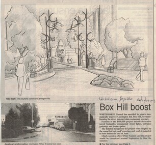
Article, Carrington Road, Box Hill, 30/04/1997 12:00:00 AM
... Mitcham melbourne carrington road box hill ption Whitehorse ...ption Whitehorse Council's plan to improve Carrington RoadWhitehorse Council's plan to improve Carrington Road Box Hill shopping precinctption Whitehorse Council's plan to improve Carrington Road carrington road, box hill -
 Whitehorse Historical Society Inc.
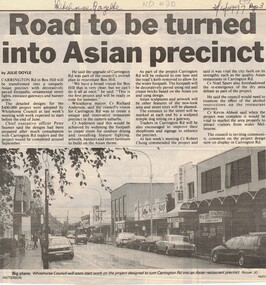
Article, Carrington Road Box Hill, 30/04/1998 12:00:00 AM
Whitehorse Council's plans to improve Carrington RoadWhitehorse Council's plans to improve Carrington Road Box Hill shopping areaWhitehorse Council's plans to improve Carrington Roadcarrington road, box hill, city of whitehorse -
Whitehorse Historical Society Inc.
Article, City puts 'dry' issue on hold, !997
... Mitcham melbourne City of Whitehorse Liquor Licencing Act Box Hill ...Whitehorse Council has backed down from making a decision on Box Hill's controversial dry area until after the return of elected councillors in March.Whitehorse Council has backed down from making a decision on Box Hill's controversial dry area until after the return of elected councillors in March.Whitehorse Council has backed down from making a decision on Box Hill's controversial dry area until after the return of elected councillors in March.city of whitehorse, liquor licencing act, box hill -
Whitehorse Historical Society Inc.
Article, Depots to merge, 1995
Whitehorse Council is considering selling the Nunawading Council depot and upgrading the Box Hill depot to cater for the new amalgamated municipality.Whitehorse Council is considering selling the Nunawading Council depot and upgrading the Box Hill depot to cater for the new amalgamated municipality. But Nunawading is likely to retain its Horticultural Centre in Forest Hill.Whitehorse Council is considering selling the Nunawading Council depot and upgrading the Box Hill depot to cater for the new amalgamated municipality.local government, city of whitehorse, council depots, amalgamations -
Whitehorse Historical Society Inc.
Article, Council 'home' inadequate, 1995
... at Box Hill own Hall. Bruce Atkinson, Koonung Province MP claims... Whitehorse Council administrative centre at Box Hill own Hall. Bruce ...Former Nunawading mayor, Noel Spurr, joined the debate over the unsuitability of the current Whitehorse Council administrative centre at Box Hill own Hall.Former Nunawading mayor, Noel Spurr, joined the debate over the unsuitability of the current Whitehorse Council administrative centre at Box Hill own Hall. Bruce Atkinson, Koonung Province MP claims parts of Nunawading Civic centre, still being used by Whitehorse Council to house some employees, could be better utilized as a District Court House for the Eastern region.Former Nunawading mayor, Noel Spurr, joined the debate over the unsuitability of the current Whitehorse Council administrative centre at Box Hill own Hall. local government, city of whitehorse, spurr, noel, atkinson, bruce, council chambers, amalgamations, box hill town hall -
Whitehorse Historical Society Inc.
Article, New city makes progress, 1994
... happening at the council offices at Box Hill and Nunawading since... happening at the council offices at Box Hill and Nunawading since ...Although it may not be apparent to residents much has been happening at the council offices at Box Hill and Nunawading since the appointment of the three commissioners to the City of Whitehorse.Although it may not be apparent to residents much has been happening at the council offices at Box Hill and Nunawading since the appointment of the three commissioners to the City of Whitehorse. Australia Day Family festival is to be held 12 noon - 10 pm Thursday 26 January at the Nunawading Civic Centre grounds.Although it may not be apparent to residents much has been happening at the council offices at Box Hill and Nunawading since the appointment of the three commissioners to the City of Whitehorse. city of whitehorse, australia day, festivals and celebrations -
Whitehorse Historical Society Inc.
Article, Council ready for change, 1994
... although frustrating waiting for the future of Box Hill ...39 metropolitan councils currently involved in second round of local government reviews are prepared for inevitable change.39 metropolitan councils currently involved in second round of local government reviews are prepared for inevitable change. Mr Dilley, City Manager and Mayor, Kevin Abbott told Nunawading councillors discussions have been fruitful although frustrating waiting for the future of Box Hill to be determined.39 metropolitan councils currently involved in second round of local government reviews are prepared for inevitable change. local government, city of nunawading, dilley, warwick, abbott, kevin, amalgamations -
Whitehorse Historical Society Inc.
Article, Hello Whitehorse, 1994
The new City of Whitehorse covering all the former Box Hill and Nunawading municipalities was officially created by State cabinet last Thursday. Women will play a greater role on Whitehorse City Council initially than in most of the other new councils created last week.The new City of Whitehorse covering all the former Box Hill and Nunawading municipalities was officially created by State cabinet last Thursday.Women will play a greater role on Whitehorse City Council initially than in most of the other new councils created last week.The new City of Whitehorse covering all the former Box Hill and Nunawading municipalities was officially created by State cabinet last Thursday. Women will play a greater role on Whitehorse City Council initially than in most of the other new councils created last week.city of whitehorse, local government commissioners, oscar, geoff, fifer, dimity, wallace, marie, payne, brian -
Whitehorse Historical Society Inc.
Article, Nunawading's happy, 1994
Nunawading council and community groups have welcomed the Local Government Board's interim proposal to amalgamate the municipality with Box Hill to become the City of Koornung.Nunawading council and community groups have welcomed the Local Government Board's interim proposal to amalgamate the municipality with Box Hill to become the City of Koornung.Nunawading council and community groups have welcomed the Local Government Board's interim proposal to amalgamate the municipality with Box Hill to become the City of Koornung.local government, city of nunawading, amalgamations -
Whitehorse Historical Society Inc.
Article, Nunawading opts to join Box Hill, 1994
... Hill Amalgamations Council debate on the amalgamation of Box ...Council debate on the amalgamation of Box Hill and Nunawading municipalitiesCouncil debate on the amalgamation of Box Hill and Nunawading municipalitiesCouncil debate on the amalgamation of Box Hill and Nunawading municipalitieslocal government, city of nunawading, city of box hill, amalgamations -
Whitehorse Historical Society Inc.
Pamphlet, Nunawading and Box hill Councils to merge, 1994
... and Box hill Councils to merge Pamphlet Pamphlet ...Pamphlet on public meting about amalgamation of Nunawading and Box Hill. 3 Nov 1994. Includes arguments for proposal.Pamphlet on public meting about amalgamation of Nunawading and Box Hill. 3 Nov 1994. Includes arguments for proposal.Pamphlet on public meting about amalgamation of Nunawading and Box Hill. 3 Nov 1994. Includes arguments for proposal.local government, city of nunawading, city of box hill, amalgamations -
Whitehorse Historical Society Inc.
Article, Council accepts merger, 1994
... Board's recommendation it be amalgamated with Box Hill. Council ...Nunawading Council was expected to accept the Local Government Board's recommendation it be amalgamated with Box Hill.Nunawading Council was expected to accept the Local Government Board's recommendation it be amalgamated with Box Hill.Nunawading Council was expected to accept the Local Government Board's recommendation it be amalgamated with Box Hill.local government, city of nunawading, amalgamations -
Whitehorse Historical Society Inc.
Article, Council service stands out, 1994
... achievements on the eve of amalgamation with Box Hill. Local government ...One hundred and thirty-five men and women have served the City of Nunawading and before that the Shire of Blackburn and Mitcham.One hundred and thirty-five men and women have served the City of Nunawading and before that the Shire of Blackburn and Mitcham. Present and past councillors recall major achievements on the eve of amalgamation with Box Hill.One hundred and thirty-five men and women have served the City of Nunawading and before that the Shire of Blackburn and Mitcham.local government, city of nunawading, shire of blackburn and mitcham, councillors, sutherland, leslie j, riddell, arthur, rooney, keith, cox, george, oakley, gavan, barelli, ken, plummer, jan, atkinson, bruce, athan, savvas, smith, dorothy g, allan, peter, spurr, noel -
Whitehorse Historical Society Inc.
Article, New Mayor's fight for City, 1994
New mayor, Cr Noel Spurr, is committed to achieving his council's aim to merge with Box Hill. He says he has a vital role to play to ensure Nunawading residents and businesses were not disadvantaged by the amalgamation.New mayor, Cr Noel Spurr, is committed to achieving his council's aim to merge with Box Hill. He says he has a vital role to play to ensure Nunawading residents and businesses were not disadvantaged by the amalgamation.New mayor, Cr Noel Spurr, is committed to achieving his council's aim to merge with Box Hill. He says he has a vital role to play to ensure Nunawading residents and businesses were not disadvantaged by the amalgamation.local government, city of nunawading, spurr, noel, amalgamations -
Whitehorse Historical Society Inc.
Article, For Nuna Council it's steady as she goes, 1994
... recommending its merger with Box Hill. Nunawading Council was divided ...Nunawading Council was divided last week over how it should proceed in the wake of the release of the Local Government Board's interim report recommending its merger with Box Hill.Nunawading Council was divided last week over how it should proceed in the wake of the release of the Local Government Board's interim report recommending its merger with Box Hill.Nunawading Council was divided last week over how it should proceed in the wake of the release of the Local Government Board's interim report recommending its merger with Box Hill.local government, city of nunawading, victoria. local government board, amalgamations