Showing 247 items
matching box hill north
-
 Ringwood and District Historical Society
Letter, Letter To the Talbot's from friend Shirley about the arrangements for Jack Harker's burial with Ruby. He died 2001
Ruby was Jack (Archie'S) wife who died in 2000. She was buried in Box Hill Cemetery but when Jack died a year later he could not be nuried with Ruby as he wished. So Shirley, who wrote the letter, related how the problem was solved by cremating Jack and then placing the ashes with Ruby. The Talbots lived in Queensland.3 pages hand written on heavy pink paper. No date or address which has been cut off.right hand corner page one. -
 City of Moorabbin Historical Society (Operating the Box Cottage Museum)
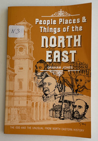
Book, Jones, Graham, People, places & things of the North East, 1981
128 p. : ill.non-fictionvictoria, history -
 Bendigo Historical Society Inc.
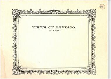
Photograph - VIEWS OF BENDIGO: COPIES OF 52 PHOTOS, 1850 - 1900
Copies of Photographs from - Views of Bendigo by Nicholas Caire Originals in Box 13 No.1 Sandhurst east/ City Reserve x 2 No 2 New Chum Line of Reef No 3 Sandhurst to North from top of Masonic Hall No.4 Hustler's Line of Reef No.5 Battery of stampers for crushing quartz x 2 No.6 View Sandhurst from top of Masonic Hall x 2 No.7 Excavation Quartz Reef, Ironbark Hill. No 8 St. Paul's Church. No.9 View Camp Reserve from Court House. No.10 View of Nth. Old Chum. No.11 View Camp Hill near the Lodge x 2 No.12 Garden Gully. No.13 Shamrock Hotel, Sandhurst. No.14 View from Court House, east end Pall Mall. No.15 Wesleyan Church, Golden Square x 2 No.16 Savings Bank, Sandhurst No.17 Bendigo District Hospital. No.18 Interior Wesleyan Church x 2 No.19 View Golden Square township. No.20 The Town Hall, Sandhurst. No 21 The City Hotel,Sandhurst. No 22 Pall Mall Sandhurst, No 23 Sandhurst City Market No 24 Pall Mall looking west x 2 No 25 Camp Hill x 2 No 26 Charing Cross No 27 View Sandhurst. x 2 No 28 Long Gully. No 29 Railway station and sheds No 30 Cemetery Back Ck. No 31 Kock's Pioneer Quartz Crushing Plant Long Gully. No 32 Masonic Hall. No 33 Bendigo Benevolent Asylum. No 34 Bendigo Flat. No 35 Old Chum Hill x 2 No 36 New Chum Gully No 37 Township of Eaglehawk No 38 From St Paul's tower looking west No 39 Tunnel Big Hill. No 40 From St Paul's tower looking south x 2 No 41 From St Paul's tower looking eastward x 2 No 42 From St Paul's tower looking north west x 2 No 43 Great Extended Hustlers Quartz Mining Claim No 44 Big Hill Rail line x 2 No 45 From St Paul's tower looking westward x 2 No 46 From St Paul's tower looking north west No 47 Big Hill Ranges Buick. x 2 No 48 St.Paul's Tower x 2 No 49 Eaglehawk township. No 50 Mitchell Street No 51 Botanical gardens, White Hills x 2 No 52 View Point, Sandhurst. .N.J. Caire.place, bendigo, bendigo area., views of bendigo. -
 Coal Creek Community Park & Museum
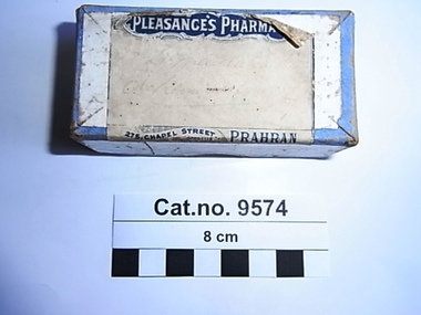
Box. Chemist, 1902-1944
Victoria Government Gazette, January 12, 1917, Medical Act 1915, Part III. – Poisons Act 1915, THE PHARMACEUTICAL REGISTER OF VICTORIA and List of Licensed Dealers in Poisons for 1917.page 130. No. of Certificate : 1704, Date of Registration :10 Feb 1915, Name : Pleasance, Charles Maxwell, Address : 275 Chapel Street, Prahran, Qualifications : Final Exam., Vict., 14 Dec., 1914. No. of Certificate : 600, Date of Registration : 14 May 1879, Name : Pleasance, George, Address : 275 Chapel Street, Prahran, Qualifications : Mod. Exam., Vict., 7 Sept., 1877. No. of Certificate : 1739, Date of Registration : 12 Jan., 1916, Name : Pleasance, George Hayward, Address : 275 Chapel Street, Prahran, Qualifications : Final Exam., Vict., 8 Dec., 1915. George Pleasance was in business alone at 84 Chapel Street Prahran from 1898 to 1906 and at 275 Chapel Street from 1902 – 1915. Charles Maxwell Pleasance joined George in the business from 1916 until George died in December 1929 after which Charles Maxwell Pleasance continued the business alone at that address until 1944. George Hayward Pleasance also joined George & Charles Maxwell Pleasance in the business from 1917 until his death in 1925. The register was not Gazetted between 1945-47 but Charles Maxwell Pleasance next appeared on the register at 17 Khartoum Street, North Caulfield, 1948-1968 and at 2 Shrimpton Court, Box Hill 1969 -1973. Pleasances were a family of homeopaths, Pharmacists and Pharmacy owners in Victoria from the 1870's to at least the 1970's.Small cardboard box with cardboard lid, white paper label with dark blue print, and faded hand written text.On label 'Pleasance's Pharmacy 275 Chapel Street, Prahran (opposite the Arcade)' with faded hand written illegible text. pharmacist, pharmacy, pleasance -
 Uniting Church Archives - Synod of Victoria
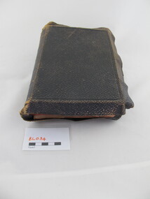
Book - Bible, Holy Bible, c1900
Leather bound bible with gilt text on the spine and gilt edged pages. The dedication page has a small newspaper cutting stuck at the bottom of the page. rev t s b woodfull -
 Uniting Church Archives - Synod of Victoria
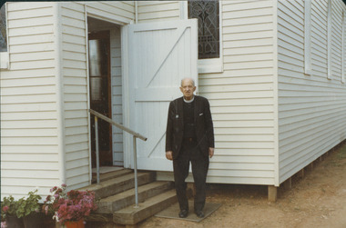
Photograph, Mitiamo UC Centenary & Rev. V. Raymond Hicks 11/11/1984, 11/11/1984
Victor Raymond Hicks (11/8/1903–19/11/1995) born at Ballarat. Trained at Otira and accepted as candidate for the ministry in 1927. Ordained 1934. Married Lillian Harvey, 4 children. Appointments to Mitiamo, Matimuk, Woomelang, Wodonga, Kerang, Springvale, Brunswick, North Fitzroy, Geelong West, Kyneton and Brown Hill (Ballarat). Chaplaincy in WW2 and at Box Hill hospital. The article about the Mitiamo church: "Fifty years ago the Rev. Raymond Hicks was minister at Mitiamo as it celebrated its Golden Jubilee. He returned for the centenary this year and powerfully preached on 'Lengthen your cords, and strengthen your stakes' (Isaiah 54:2). He spoke of the great need of the church today to have a passion to lead men and women to Christ. Also sharing in the service were the Rev. Ray Scholl, a Mitiamo member before entering the ministry, and present minister, the Rev. M. Thalheimer. The centenary weekend began with an old fashioned tea meeting and concert. The Sunday school hall housed a comprehensive display of photos and historical records dating back to the Bible Christian days of 1884. Mrs Thirza Phelan has researched and written the church history. FOOTNOTE: The first minister, Mitiamo's the Rev. Daniel Daley, preached at the Golden Jubilee service—Mr Hicks has followed an ancient tradition."Colour photograph of Rev. V. Raymond Hicks standing outside the front of a wooden church porch.C&N identification.rev raymond hicks, home missionary, methodist ministry, otira -
 Uniting Church Archives - Synod of Victoria
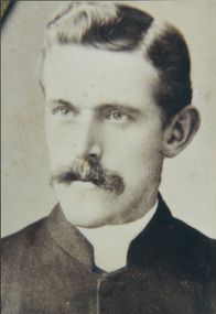
Photograph, Reverend Wesley Johns
Reverend Wesley Johns was born in Victoria in 1864 and died in Box Hill in 1933. He commenced his ministry in 1886. He was stationed at Benalla and Euroa 1886, Wodonga 1887 Dromana 1888 Nathalia 1889 Kerang 1890 Horsham 1893 Blackwood 1895 Kilmore 1898 Forth 1901 Wangaratta 1904 Portland 1907 Brighton New Street 1910 North Melbourne 1912 Colac 1916 Ringwood 1921 St Kilda 1924 Oakleigh 1926. He was Financial Secretary of District between 1918 and 1926.B&W photograph head and shoulders.johns, wesley, reverend -
 Box Hill Historical Society
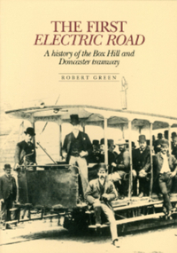
Book, Green, Robert, The First Electric Road - A History of the Box Hill and Doncaster Tramway
This book gives a brief description of tramways around the world before focussing on Box Hill-Doncaster's very own. The tramway - the first electric one in the Southern Hemisphere - operated from 1889-1896. It ran from Whitehorse Road along Station Street north to Doncaster Road Intersection. Photos. Index.arnot> arthur, draper> thomas, laurie> david, meader> william, masters> william, serpell> richard, glassford> matthew, aspinall> joseph w., cockcroft> george, collier> samuel, ellingworth> william, inglis> john, mcmurdie> f.a., padgham> silas, rawlings> alfred, serpell> alfred, wright> george, wright> james, wright> john, wright> william edward, lauer> a.c.h., transport, tram services, station street, box hill, elgar road, doncaster, doncaster road, box hill and doncaster tramway company -
 Whitehorse Historical Society Inc.
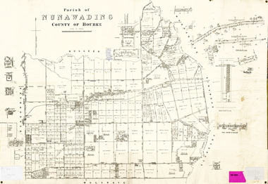
Legal record - Map, Parish of Nunawading, c1930
Office of Lands and survey map, 1864 with many further subdivisions of 1870 onwards added.Office of Lands and survey map, 1864 with many further subdivisions of 1870 onwards added. Boundaries of City of Box Hill included. Note added re Slater's land in Blackburn North. Office of Lands and survey map, 1864 with many further subdivisions of 1870 onwards added. maps, shire of blackburn and mitcham, city of box hill, slater family -
Whitehorse Historical Society Inc.
Article, Happy hour, 1979
Photocopy of article concerning visits by Box Hill and Nunawading councillors to Box Hill Technical College in 1979.Photocopy of article concerning visits by Box Hill and Nunawading councillors to Box Hill Technical College in 1979.Photocopy of article concerning visits by Box Hill and Nunawading councillors to Box Hill Technical College in 1979.box hill technical college, city of box hill, city of nunawading, fountain, geoff, madden, john, dempsey, bill, whittaker, harold, arrowsmith, valda, nunawading north neighbourhood centre -
Whitehorse Historical Society Inc.
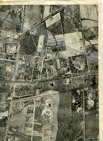
Map, Aerial photographs Nunawading, 1972
Department of Crown Lands and Survey, Melbourne, 1972.Department of Crown Lands and Survey, Melbourne, 1972. Project runs 34 - 39 - City of Nunawading. frames numbered from South to North boundaries, each strip numbered from West to east. The series extends further West to Box Hill and East to Ringwood than the 1970 project. No index map. Sheets 39/2 and 34/28 missing.non-fictionDepartment of Crown Lands and Survey, Melbourne, 1972.victoria. department of crown lands and survey, aerial photographs, nunawading, mitcham, blackburn, blackburn north, blackburn south, forest hill, vermont, burwood east, box hill, ringwood, vermont south -
Whitehorse Historical Society Inc.
Map, Aerial photographs Nunawading, 1976
Department of Crown Lands and Survey, Melbourne, 1976 Project.Department of Crown Lands and Survey, Melbourne, 1976 Project. Runs 29 - 33 City of Nunawading. Frames numbered from South to North boundaries, each strip numbered from West to East. No index map. Sheets 30/8 and 30/9 missing.non-fictionDepartment of Crown Lands and Survey, Melbourne, 1976 Project. victoria. department of crown lands and survey, aerial photographs, nunawading, mitcham, blackburn, blackburn north, blackburn south, forest hill, vermont, vermont south, burwood east, box hill, ringwood -
Whitehorse Historical Society Inc.
Map, Waverley, c1985
Map of Waverley, including Box Hill Soiuth, Blackburn South, Vermont, Vermont South, Burwood East, Burwood, Ashburton, Mount Waverley, Glen Waverley, Oakleigh South, Clayton North and Mulgrave.Map of Waverley, including Box Hill Soiuth, Blackburn South, Vermont, Vermont South, Burwood East, Burwood, Ashburton, Mount Waverley, Glen Waverley, Oakleigh South, Clayton North and Mulgrave. UBD map issued by Nicholls Gledhill Real Estate Agents. Scale 1:50,000.Map of Waverley, including Box Hill Soiuth, Blackburn South, Vermont, Vermont South, Burwood East, Burwood, Ashburton, Mount Waverley, Glen Waverley, Oakleigh South, Clayton North and Mulgrave. blackburn south, burwood east, vermont, vermont south, forest hill -
Whitehorse Historical Society Inc.
Map, Aerial maps, 2/04/1966 12:00:00 AM
Melbourne 1966 project, runs 10A and 11A, lens 122 151.75 mm 9,800. Photo nos 77, 107, 109, 161, 163, 165.Melbourne 1966 project, runs 10A and 11A, lens 122 151.75 mm 9,800. Photo nos 77, 107, 109, 161, 163, 165. Areas and boundaries: Map no 77 W. Park and Cook Roads; E. Dubon Rd; N Oban Rd; S Reilly St. Map No 107. W. Indra Rd and Pakenham St; E. Rooks Rd & McLares Rd; N. Maroondah Hwy; S. Hawthorn Rd & Eley Rd. Map No 109 W. Elgar Rd. E. Blackburn Rd & McKean St; S. Eley Rd & Burwood Hwy. Map No 161. W. Elgar Rd & Huntingdale Rd; E. Blackburn Rd; N. Burwood Hwy; S. Waverley Rd. Map No 163. W. Blackburn Rd; S. Springvale Rd; N. Eley Rd & Hawthorn Rd; S. Glen Waverley Railway Line. Map No 165. W. Stanley Rd, Vermont South; E. Cathies Lane, Wantirna South; N. North of Burwood Hwy; S. High Street. Melbourne 1966 project, runs 10A and 11A, lens 122 151.75 mm 9,800. Photo nos 77, 107, 109, 161, 163, 165. aerial photographs, blackburn, blackburn south, forest hill, nunawading, box hill, burwood, burwood east, donvale, mount waverley, glen waverley, wantirna, vermont south, mitcham, ringwood north, ringwood -
Whitehorse Historical Society Inc.
Map, Burwood Road, Box Hill City, 15/02/1952 12:00:00 AM
Detailed map of subdivision along the north side of Burwood Road, Box Hill between Station Street and Middleborough Road.Detailed map of subdivision along the north side of Burwood Road, Box Hill between Station Street and Middleborough Road. Shows many block owners, types of buildings, nature of fencing. Marked as 'Survey Plan No 5440'.Detailed map of subdivision along the north side of Burwood Road, Box Hill between Station Street and Middleborough Road. maps, burwood road, burwood, andrews street, greenwood street, tennyson street, middleborough road, station street -
 Whitehorse Historical Society Inc.
Map, Photo-map Ringwood A4A, 1945
Aerial photo covering approximately from Box Hill to Mitcham (West to East) and Springfield Road to Hawthorn Road (North to south).Aerial photo covering approximately from Box Hill to Mitcham (West to East) and Springfield Road to Hawthorn Road (North to south). Names of main roads inscribed.Aerial photo covering approximately from Box Hill to Mitcham (West to East) and Springfield Road to Hawthorn Road (North to south).aerial photographs, box hill, blackburn, nunawading, forest hill, mitcham -
Whitehorse Historical Society Inc.
Document, Allens Real Estate, 2011
... , Burwood, Box Hill, Box Hill South, Mitcham, Mont Albert North... North, Blackburn South, Burwood, Box Hill, Box Hill South... North Blackburn South Box Hill Box Hill South Burwood Doncaster ...Promotional brochures detailing property values, recent sales and historical background.Promotional brochures detailing property values, recent sales and historical background. Includes Blackburn, Blackburn North, Blackburn South, Burwood, Box Hill, Box Hill South, Mitcham, Mont Albert North, Nunawading, Doncaster East, Vermont.Promotional brochures detailing property values, recent sales and historical background.blackburn, blackburn north, blackburn south, box hill, box hill south, burwood, doncaster east, mitcham, nunawading, mont albert north, vermont -
Whitehorse Historical Society Inc.
Map, Eastern Suburbs, 1922
Enlargement of sections of 1922 Ringwood Commonwealth Survey - Imperial General Staff (West - Camberwell; North - Templestowe; East - Ringwood; South - Clayton)maps, nunawading, tunstall, box hill, blackburn, mitcham, vermont, burwood east, mont albert -
Whitehorse Historical Society Inc.
Document, Surrey Road, Blackburn North, 1/02/2000
... : Whitehorse Partners First National, Box Hill. Surrey Road, Blackburn ...Auction brochure for 3 bedroom weatherboard house at 90 Surrey Road, Blackburn North, for auction 12 February 2000. Agent: Whitehorse Partners First National, Box Hill.surrey road, blackburn north, no 90, auctions -
 Whitehorse Historical Society Inc.
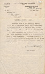
Letter - Correspondence, Postal land - Blackburn, 1/06/1924
Letter from the Crown Solicitor to Edgar Erikson, orchardist, re compulsory acquisition of land for postal use. He was paid 264 pounds.land titles, eriksson, edgar, junction road, blackburn north, australia. crown solicitors office, johnston, louisa caroline, station street, box hill, post offices -
 Whitehorse Historical Society Inc.
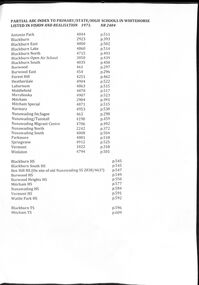
Document - Centenary History of State Education in Victoria, Victorian Education Department, Centenary History, 1973
Selected pages of schools in the Nunawading area from "Vision and Realisation". A Centenary History of State Education in Victoria. N.B. State schools are now called Primary SchoolsA list and description of schools in Whitehorse from "Vision and Realisation"A4 photocopy of 58 selected pages from "Vision and Realisation": a "Centenary History of State Education in Victoria" by the Victorian Education Department. Volume 3 dealing with schools in the Nunawading areavictorian education department, burwood east state school no.454, nunawading (sagoe common school) (box hill) no.463, nunawading (boroondara) catholic school no.464, nunawading state school (canterbury road) no.469, vermont state school. no 1022, burwood east state school no 461, nunawading north state school no 2242, mitcham state school no.2904, blackburn state school no.2923, blackburn open air school no.3850, blackburn south state school no. 4035, nunawading state school no.4190, forest hill state school no.4251, nunawading migrant centre no.4706, blackburn north state school no.4715, tally ho training farm no.3588, winlaton girls youth training centre no.4794, blackburn east state school no.4800, nunawading south state school no.4808, antonio park state school no.4844, blackburn lake state school no.4860, laburnun state school no.4863, mitcham special school no.4871, blackburn high school, blackburn south high school, mitcham high school, nunawading high school, vermont high school, mitcham technical school, primary schools, secondary schools, blackburn technical school -
 Ballarat Heritage Services
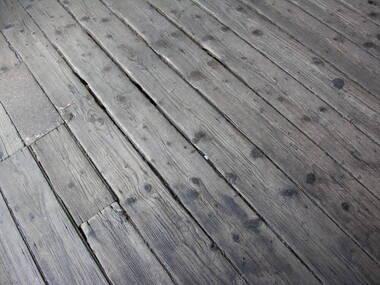
Photograph - Photograph - Colour, Timber Floor on the North Platform, Ballarat Railway Precinct, 2017
Colour photograph of fwell worn timber floor boards at the Ballarat Railway Station. ballarat railway station, floor boards -
 Ballarat Heritage Services
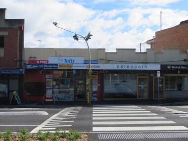
Photograph, Clare Gervasoni, North Kew Newsagency, 93 Willsmere Road, North Kew, 2017, 10/07/2017
North Kew Newsagency, 93 Willsmere Road, North Kew.north kew newsagency, north kew village, newsagent, willsmere road, kew north -
 Ballarat Heritage Services
Photograph - Colour, Clare Gervasoni, Ludbrook House, Ballarat, 2016, 30/07/2016
Colour photography of a double storey building in Lydiard Street North, Ballarat.ludbrook house, lydiard street, ballarat -
 Ballarat Heritage Services
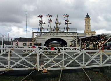
Photograph - Digital photographs, L.J. Gervasoni, Railway Gates Ballarat, c2013
Colour photograph of operational railway gates across Lydiard Street North, Ballarat.ballarat, ballarat railway station, gates, railway gates, heritage, cultural landscape, crossing, signals -
 Ballarat Heritage Services
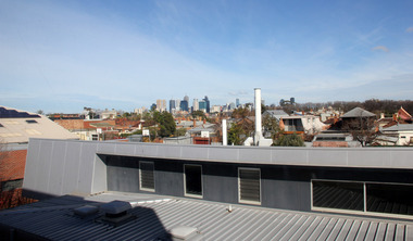
Digital photographs, L.J. Gervasoni, Looking Towards Melbourne City and inner north from Fitzroy High School, 2013
Colour photograph looking towards the Melbourne Central Business District.melbourne, viewscape, cbd, inner north, cityscape -
 Ballarat Heritage Services
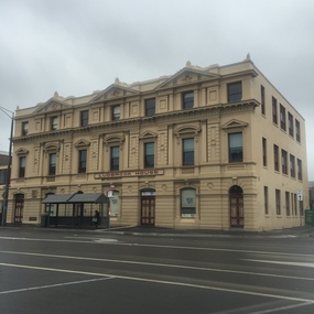
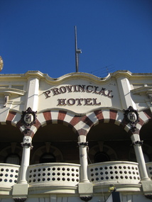
Photograph - Colour, Provincial Hotel, Lydiard Street North, Ballarat, 2015, 15/12/2015
Colour photograph of a detail of the facade of the Provincial Hotel in Ballarat.provincial hotel, hotels, ballarat -
 Ballarat Heritage Services
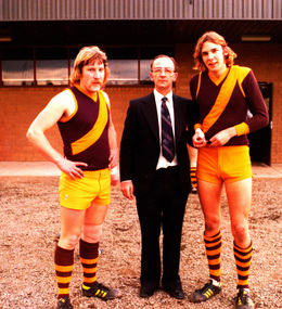
Photograph - digital copy, K.P. Gervasoni, North Kew Rovers footballers Peter Cooper and Niall McAllister with Mayor of Kew Cr Jack Gervasoni),1979, 1979
Jack and Kathleen Gervasoni ran the North Kew Authorised Newsagency at 93 Willsmere Road for 17 years. Peter Cooper and Niall McAllister where two of a multitude of paperboys who worked at the newsagency.Copy of colour photograph of two North Kew Rovers Footballers with City of Kew Mayor Cr John H. Gervasoni. Left to right: Peter Cooper, Jack Gervasoni, Niall McAllister at Stradbroke Park, Kewkew, gervasoni, jack gervasoni, mayor, team, sport, football, cooper, stradbroke park, peter cooper, neil mcalister, paperboys, j.h. gervasoni, niall mcalister -
 Ballarat Heritage Services
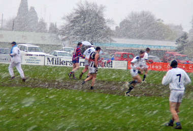
digital photographs, Central Highlands Football League Grand Final in the Snow, 2004, 2004
Hepburn Football Club are victors in a Australian Football League grandfinal which was played in the snow at North Ballarat. hepburn burras, footy, football, grand final, snow, weather, chfl, hepburn fooball club -
 Ballarat Heritage Services
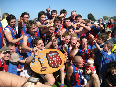
digital photographs, Lisa Gervasoni, Central Highlands Football League Grand Final, 2004, 2004
The grand final was played at the North Ballarat Football Ground.Colour photograph of Premiers of the CHFL for 2004, Hepburn Football Club.hepburn burras, footy, football, grand final, chfl, reserves, captains