Showing 2073 items
matching burkes
-
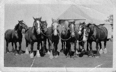 Hymettus Cottage & Garden Ballarat
Photograph, Archie Burke's Ploughing Team Dooboobetic
Mr William Burke settled at Dooboobetic near Donald in the 1860s his sons eventually working their own farms on subdivisions of the original property. Archibald (Archie) whose team is pictured had a portion named "Inverleigh". His daughter married Mr Michael Taffe of "Hymettus" Ballarat where the photographic archive survives. small snapshot image badly creased of team with inscription and print on reverse.Written on reverse "G'pa Burke's team. with printed words KODAK PRINT and ink stamp 431 -
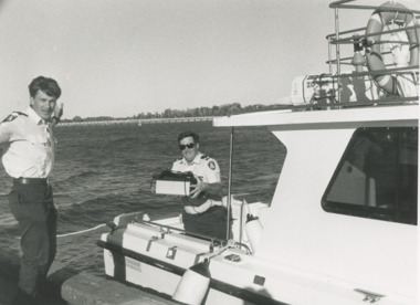 Lakes Entrance Historical Society
Photograph - Paynesville Water Police, Lakes Post Newspaper, 1/04/1996 12:00:00 AM
Water Police Snr Const. Tony Burke and Snr Const. Brian Hall of Paynesville Water Police docked at Lakes Entrance Victoria. An abandoned EPFRG emergency position indicating Beacon set off the alarm in Canberra initiating a full emergency response with helicopter, water police, coastguard and other units involved. The EPFRG was eventually located in a rubbish bin on a private property in Lakes EntranceBlack and white photograph of two Water Police Snr Const. Tony Burke and Snr Const. Brian Hall of Paynesville Water Police docked at Lakes Entrance Victoriacoast, defence services, police -
 Kew Historical Society Inc
Photograph, Burke Hall, Xavier Preparatory School, circa 1930, c. 1930
This work forms part of the collection assembled by the historian Dorothy Rogers, that was donated to the Kew Historical Society by her son John Rogers in 2015. The manuscripts, photographs, maps, and documents were sourced by her from both family and local collections or produced as references for her print publications. Many were directly used by Rogers in writing ‘Lovely Old Homes of Kew’ (1961) and 'A History of Kew' (1973), or the numerous articles on local history that she produced for suburban newspapers. Most of the photographs in the collection include detailed annotations in her hand. The Rogers Collection provides a comprehensive insight into the working habits of a historian in the 1960s and 1970s. Together it forms the largest privately-donated collection within the archives of the Kew Historical Society.A panoramic photograph of the grounds of Xavier Preparatory School taken from the vicinity of Studley House, looking north east towards Burke Hall (originally Studley Hall). The foreground to the left of the chapel is an oval known as the Chapel Oval (later known as Studley Oval). The ground to the right front is now known as the Jack Gervasoni oval. The house to the far right (part view) is "Campion".Burke Hall (Xavier Preparatory School) formerly Waverley. Built by Charles Griffiths ca. 1869 (Panoramic view from East [sic]) burke hall, studley hall, xavier preparatory school, kew, studley park, dorothy rogers, chapel oval, jack gervasoni oval, burke hall chapel, studley oval, charles griffiths -
 Bendigo Military Museum
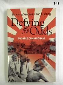
Book, Lothian Books, Defying the Odds: Surviving Sandakan & Kuching, 2006
Defying the Odds tells the story of officers of B & E Forces interred at Sandakan & Kuching during World War II.Soft card cover. Red & cream cover illustrated front & back. Title on cover & spine in black letters. 237 cut edge pages. Black & white illustrations.On first page: Len Burke 12.10.06, Donated by Len Burke.books, military, history, valour -
 Kew Historical Society Inc
Photograph, Burke Road Bridge, 1930s
Without bridges, Kew remained cut off from the City of Melbourne, only being accessible by Punt. Private and public bridges were constructed from the 1850s, beginning with the Hawthorn Bridge linking Bridge and Burwood Roads. A bridge across the Yarra at Burke Road was created as early as 1873. Since that first wooden bridge, a number of later bridges, typically on concrete pylons have been built, in 1926 and again during the 1970s.Sepia, faded photograph of the Burke Road Bridge linking East Kew and Ivanhoe. The previous bridge, constructed in 1926 was submerged beneath the flood waters in the 1934 mega-flood of the Yarra.burke road bridge (kew), bridges -- river yarra -
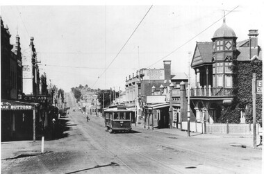 Melbourne Tram Museum
Photograph - Black & White Photograph/s, Bob Prentice, c1915
Black and white photograph of PMTT No. 57 in Burke Road Camberwell c1915. Tram showing route No. 12. Possibly at Mayston St. In the view is the State Savings Bank, a Real Estate agent, a snooker hall and a button shop. Photograph features on page 59 of Ian Brady's book on the PMTT, "Melbourne's Foremost Municipal Tramway". Photograph from the Bob Prentice Collection - from the Rose Series post-card P3639. Two copies held.Has caption on the photo "Burke Road, Camberwell c1920's" and in pencil on the rear 'RSCP 325", C1916 and in red ink "H57"trams, tramways, pmtt, burke road, camberwell, tram 59 -
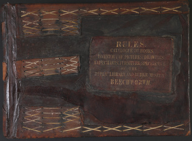 The Beechworth Burke Museum
Book - 1875 Catalogue, William Detmold, RULES / CATALOGUE OF BOOKS / INVENTORY OF PICTURES, DRAWINGS, / MAPS, CHARTS, FURNITURE, SPECIMENS / OF THE / PUBLIC LIBRARY AND BURKE MUSEUM / BEECHWORTH, 1875
This large, leather bound journal was made for the Public Library and Burke Museum in Beechworth by book manufacturer, William Detmold in 1875. It was commissioned by the President of the Library and Burke Museum committee, Dr Antoine Mousse, for the purpose of cataloguing all the items in the collection. The cataloguer was the curator at that time, William Morton, whose hand-writing appears in the journal today. When William Morton first started recording in this journal in 1875, there were already a number of existing items in the institution. The Public Library and Burke Museum in Beechworth had actually been operating since the 1850s; first as a Young Men’s Association in 1856, then as Beechworth Athenaeum in 1858, then as the Beechworth Public Library in 1860. Then in 1861 when news of the death of Beechworth’s former police superintended, Robert O’Hara Burke, reached the town, it was agreed that the Public Library would also become a museum to tribute his legacy, renaming it as the ‘Public Library and Robert O’Hara Burke Memorial Museum, Beechworth’. Many of the items from the early institutions would have been used to form the nucleus of this new organisation. Plus, the additional items that were either collected or donated to develop it into a museum. The catalogue is extensive. There are exactly 461 pages of recorded items, each page detailing the various collections the museum acquired in the late 19th century. Collections recorded in this catalogue include a large collection of geological specimens, that were given to the museum in 1868 by the Geological Survey Department of Victoria. A large collection of taxidermy mounts, that were given to the museum as skins by the Museum of Australia in 1865. An extensive collection of Aboriginal artefacts that were purchased from amateur anthropologist R. E . Johns in 1868. As well as artworks, charts, photographs, machinery, maps etc., all of which have been held in the museum since. This catalogue also details the governance and management of the organisation. There were originally 30 rules that governed the actions for the management committee and, while anyone could read in the free library, only subscribers could borrow two books and one periodical. At first, subscriptions rates were 7/6 a quarter. This was later changed to £1 per annum, paid quarterly in advance. This was a considerable amount; 7/6 per quarter meant that the annual fee was £1.10. This was equivalent to about £650.00 or about $1,182.00AUD today, while the reduced subscription fee of £1 a year was the equivalent to £450.00 or about $818.00AUD today. Membership of the athenaeum would have been the reserve of the town's notable citizens. The vale of the catalogue lies not only in its historical connect with the establishment of the Athenaeum and the current museum, but also in its record of the names and positions of all members of the institution's committees of management from 1875-1876. This is a unique object that contains important records for a notable country town. Large brown leather bound book made in 1875 for the Beechworth library and museum by William Detmond. Inside is a comprehensive and detailed itemised listing of the paintings, drawings, charts, photographs, specimens and books that entered the institution from 1850 -1882. non-fictionCover: RULES / CATALOGUE OF BOOKS / INVENTORY OF PICTURES, DRAWINGS, / MAPS, CHARTS, FURNITURE, SPECIMENS / OF THE / PUBLIC LIBRARY AND BURKE MUSEUM / BEECHWORTHburke museum, beechworth, catalogue, museum catalogue, 1875, william morton, william detmold, exposition universelle, ferdinand von mueller, public library, collection, book, leather bound, restored, digitised, robert o'hara burke, hand-written -
 4th/19th Prince of Wales's Light Horse Regiment Unit History Room
Book, Harrison & Sons, Animal Management 1908, 1914
Hard covered book, reprinted 1914, covering animal management in the British Army. It deals mainly with horses but also mules, donkeys and oxenSigned by Alan Burkebook, animal management, british army -
Eltham District Historical Society Inc
Folder, Robert Burke, 1860s
Folder of information on Robert Burke, bushranger 1860srobert burke, bushrangers -
 Kew Historical Society Inc
Plan, F R Simms & Son, Land for Private Sale: Cnr Victor Avenue and Mont Victor Road, Kew, 1950-1960
George Rimington established The Parkhill Nursery in 1877. By 1910, it was more commonly known as Rimington’s Nurseries and well known for its sale of violets. After World War II, Rimington’s Nurseries were gradually subdivided and sold. The 38 allotments were released in sections, including lots 34 to 36 on the corner of Mont Victor Road and Victor Avenue. Previous lots in the subdivision had bordered Burke Road, Rimington Avenue, Heather Grove, and Stoke Avenue. The selling point as it had been in comparable estates for a century were the proximity to transport, schools and churches, as well as the high location and excellent views. The subdivision plan shows most of the lots in the entire subdivision: 1-11, 13-26, and 34-38. Presumably, lot 12 and lots 27-33 were still to be released.Subdivision plans are historically important documents used as evidence of the growth of suburbs in Australia. They frequently provide information about when the land was sold on which a built structure was subsequently constructed as well as evidence relating to surveyors and real estate and financial agents. The numerous subdivision plans in the Kew Historical Society's collection represent working documents, ranging from the initial sketches made in planning a subdivision to printed plans on which auctioneers or agents listed the prices for which individual lots were sold. In a number of cases, the reverse of a subdivision plan in the collection includes a photograph of a house that was also for sale by the agent. These photographs provide significant heritage information relating house design and decoration, fencing and household gardens.Subdivision plan advertising five superb home sites among lots in Burke Road, Stoke Avenue, Victor Avenue, Mont Victor Road and Heather Grove.subdivision plans - kew, rimington avenue -- kew (vic.), heather grove -- kew (vic), stoke avenue -- kew (vic.), burke road -- kew (vic.), mont victor road -- kew (vic.) -
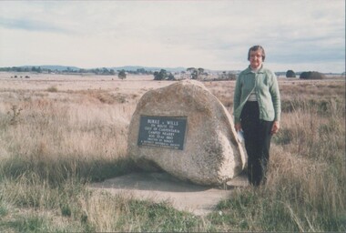 Bendigo Historical Society Inc.
Photograph - EDITH LUNN COLLECTION: BURKE & WILLS CAIRN AT LANCEFIELD 14/05/1988
Burke & Wills Cairn at Lancefield 14/05/1988Edith Lunn -
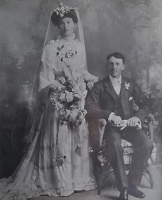 Hymettus Cottage & Garden Ballarat
Photograph - Wedding Photograph, Archibald Burke and Eleanor McKew wedding day
Wedding photograph of Archibald (Archie) Burke and Eleanor McKew.Nilburke, mckew, st arnaud, wedding photography -
 Kew Historical Society Inc
Photograph - Civic event in Stradbroke Park, 1976
Stradbroke Park. Extent: Kilby Road to Harp Road at Burke Road. Historical Documentation: 1851 - Portion 91 purchased by Edward Glynn; 1888 - The Harp of Erin Estate (which included Section 91) offered for sale; 1896 - The area now known as Stradbroke Park was bisected by a creek that flowed from the Yarra via Hay's Paddock (q.v.) and extended through to Burke Road; 1943 - W.D. Birrell, Town Clerk of Kew, proposed that the creek be filled and a reserve created; 1954 - Entire area designated as 'open space' and named 'Stradbroke Park'. The line of the creek that ran through the Park created a further reserve on the north side of High Street, now known as 'Harrison Reserve'. Existing Condition: The park is largely of mown grass that has mature trees set into it It is possible that a number of these are remnant of the original vegetation, while there are also a number of exotic trees introduced, particularly at the northern end of the park. The southern end is dominated by playing fields. (Source: Sanderson, P 1988. Kew Conservation Study)Colour photographic positive (with colour degradation) of sporting teams at a civic event in Stradbroke Park in Kew East in May 1976. The event was officiated by the Mayor of Kew, Cr Alan Hutchinson. Stradbroke Park is situated on the western boundary of Kew and bordered by Burke and Harp Roads.stradbroke park, cr alan hutchinson, team sports -- kew (vic.) -
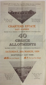 Kew Historical Society Inc
Plan - Subdivision Plan, Charteris Estate, East Ivanhoe, 1939
The Charteris Estate in Ivanhoe was sold in a number of sections. Copies of a subdivision plan of the first section is in the State Library of Victoria collection. This later section of the Charteris Estate includes lots in the Government Boulevard, Castella Street, McArthur Road, Burke Road North, Charteris Drive and Warncliff Road.Subdivision plans like that for the Charteris Estate are invaluable records for local historians identifying when lots in streets were promoted for sale.Four-fold brochure advertising the Charteris Estate in East Ivanhoe in 1939. Streets named on the plan include: the Government Boulevard, Castella Street, McArthur Road, Burke Road North, Charteris Drive and Warncliff Road. The brochure contains photos of Charterisville, the home of F De Castella Esq and also of attractive rolling hills. Annotations in pencilcharteris estate - east ivanhoe (vic), subdivision plans - east ivanhoe (vic) -
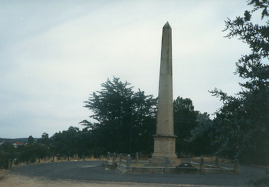 Ballarat Heritage Services
Photograph - Photograph - Colour, Clare Gervasoni, Burke and Wills Memorial, Castlemaine, c2007
Robert O'Hara's last position before leaving on the expedition to reach the Gulf of Victoria was with the police force in Castlemaine. Four sided memorial for Robert O'Hara Burke and Wills in Castlemaine. robert o'hara burke, castlemaine, memorial, burke and wills -
 Bendigo Historical Society Inc.
Photograph - BURKE & WILLS BUS TOUR, 21 August 2010
DVD. Burke and Wills bus tour, 21st August 2010. -
 Melbourne Tram Museum
Photograph - Black and White photograph, 11/01/1925 12:00:00 AM
Black and white photograph of MMTB B class No. 23 taken from a front verandah on its first trip at the corner of High St and Woodlands Ave 11-1-25 on the return trip from Burke Road to Kew Depot. A young lady is standing by the front fence. The tram is well loaded with passengers and possibly the conductor standing in the rear section of the tram, revelling at speed.On rear in ink "MMTB No. 23 taken from a front verandah on its first trip at the corner of High St and Woodlands Ave 11-1-25 on the return trip from Burke Road to Kew Depot."trams, tramways, high st kew, b class, opening, tram 23, mmtb -
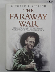 Bendigo Military Museum
Book, The Faraway War. Personal Diaries of the Second World War in Asia and the Pacific
Hard cover - Black with author and title in gold on spine. White dust cover - photo of solder on front and six photos on back. 704 pages - illustrated - 7 mapsDonated by Len Burke on fly leafdocuments-diaries, military history -
![Photograph - Construction of the F19 [Eastern Freeway], Ron Setford, May 1976](/media/collectors/550653872162f11fb04854aa/items/6828828d64071e7c58e68949/item-media/682882ac64071e7c58e68b4b/item-fit-380x285.jpg) Kew Historical Society Inc
Kew Historical Society IncPhotograph - Construction of the F19 [Eastern Freeway], Ron Setford, May 1976
Ron Setford and his wife Grace Setford lived in Tanner Avenue, East Kew, from c.1946 to c.1995. A keen photographer, he recorded the changing face of Kew over a 20 year period. Apart from 30 photographs of built structures and places in Kew dating from 1960 and 1961, 145 of his 35mm colour slides chronicle the development of the F19 (later renamed Eastern) Freeway through the Yarra Valley in Kew over a five year period from c.1972 to c.1977. This important collection was donated to the Society by his granddaughter in 2025.This collection of 175 35mm slides is of local and statewide significance, owing to its subject matter, particularly the major development of road transport infrastructure during the 1970s with the construction of the Eastern Freeway. The photographer also took care to annotate and date most of his slides which enable the researcher to pinpoint temporal and spatial locations."Dual highways towards Burke Rd"ron setford, eastern freeway, f19 freeway -
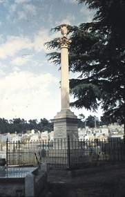 Bendigo Historical Society Inc.
Slide - BENDIGO BUILDINGS & SCENERY, Dec 1960
Slide. Bendigo Buildings & Scenery. Burke and Wills Monument at Bendigo Cemetery.slide, bendigo, bendigo buildings & scenery., bendigo buildings & scenery. -
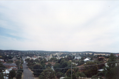 Ballarat Heritage Services
Photograph - Colour, Clare Gervasoni, Castlemaine from the Burke and Wills Memorial, c2007, c2007
Colour photograph showing a townscape of Castlemaine from the Burke and Wills Memorial.castlemaine, burke and wills memorial, townscape -
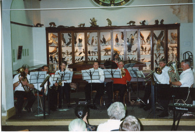 The Beechworth Burke Museum
Photograph, 1999
This photograph depicts members of the Beechworth Band at a 'Liedertafel' concert in the main hall at the Burke Museum in 1999. The concert was associated with an exhibition titled, 'From the Liedertafel to the Skating Rink: Entertainment in Beechworth 1852 - early 1900s', which celebrated the rich and diverse entertainments that were a part of Beechworth life in the nineteenth and early twentieth centuries. Marching bands, choirs, circus acts, theatrical performances, races, and seasonal activities, such as Mr. Spiller's roller skating rink, founded in the late 1860s, were among the attractions on offer. 'Liedertafel' is a tradition that accompanied German settlers to Australia. It refers to a friendly society of men united by an enthusiasm for singing. The Beechworth Brass Band was formed by Mr. H. Vandenberg in 1887. The Beechworth Liedertafel was established 14 March 1894 at the London Tavern, Camp Street, Beechworth, by Mr. A.A. Billson, and a visiting conductor, Mr. H. Fielder. German clubs, complete with marching bands, athletics associations and Liedertafel choirs, were centres of social activity attracting wide audiences not limited to members of their own ethnicity. Alfred Arthur Billson was the youngest son of Mr. George Billson, who served as Beechworth’s mayor between 1869-1871. In 1872, George purchased the Oven’s Brewery in Last Street, which became Billson’s Brewery, one of the oldest continuing beverage manufacturers in Australia. An active member of Beechworth’s cultural, business and political life around the turn of the century, A.A. Billson served on Beechworth Shire Council from 1884 to 1893, and from 1895 to 1910, with three terms as president (1888–89, 1899–1901, 1908–09). He founded the Beechworth Progress Association in 1891 and produced an ‘Illustrated Guide to Beechworth and Vicinity’ to develop tourism potential. This photograph of the Beechworth Band playing at the Burke Museum is historically significant for the information it conveys about an exhibition at the Burke Museum between September and November 1999. The use of the contemporary Beechworth Band in a 'Liedertafel' performance provides insight into curatorial approaches at the turn of the twenty-first century and improves our understanding of how exhibitions use objects in the Burke Museum's Collection to tell stories about the past in the present. The image is historically and socially significant for attesting to the enduring appeal of local musical associations, which were a popular means of entertainment that fostered social connections among settlers from diverse ethnic backgrounds. Rectangular colour photograph printed on matte photographic paper. Reverse: 7029 / Label: 7029 / Source / Burke Museum / Beechworth / Band / 1999/2000 /liedertafel, beechworth band, burke museum, from the liedertafel to the skating rink, entertainment in beechworth 1852 - early 1900s, gold rush, immigration, beechworth's german heritage, london tavern beechworth, beechworth's first brick tavern, spiller's skating rink, vandenberg's beechworth brass band, protestantism, teetotallism, skating carnivals, beechworth german association, yma's, beechworth skating rink, progress societies, billson's brewery, german-australians, beechworth progess association, lodges, freemasonry, colonial australia -
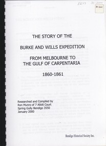 Bendigo Historical Society Inc.
Book - THE STORY OF THE BURKE AND WILLS EXPEDITION, 2000
The Story of the Burke and Wills Expedition. From Melbourne to the Gulf of Ccarpentaria, 1860 - 1861.Ron Munroaustralia, pioneer history and early australia -
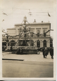 Ballarat Heritage Services
Photograph - Photograph - Black and White, Ballarat Celebrations 1937, 1937
I suspect that these are photographs before the celebrations for the coronation. See The Argus 13 May 1937 "Celebrations in Many Country Towns" Ballarat Celebrations BALLARAT Wednesday - Special Coronation celebrations were largely attended In the morning there was a service In Christ Church, at which representatlves of the council and other public bodies were present There was a similar gathering in St Andrew's Kirk At a civic service in the Alfred Hall in the afternoon the address was given by the Bishop of Ballarat (the Right Rev W Johnson). Bishop Johnson spoke of the personal association of King George V with his people, and said that the present King and Queen would be equally concerned with the welfare of their subjects The Revs H A Horsfall and B E Williams co-operated In the service, which was presided over by the Mayor (Councillor J Pryor) Mr Lloyd Lindsay recited Mase?Coronation ode and Miss W Ritchie sang "Land of Hope and Glory ' At night a Coronation concert was held in the Alfred Hallblack and white photograph of the Burke and Wills Fountain decorated for the Ballarat Celebrations in 1937.max walters, ballarat, celebrations, burke and wills fountain, anniversary -
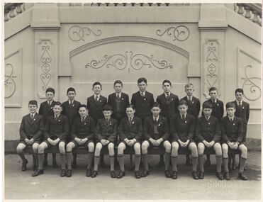 Kew Historical Society Inc
Photograph, Class photograph, Xavier Preparatory School, c. 1965
This work forms part of the collection assembled by the historian Dorothy Rogers, that was donated to the Kew Historical Society by her son John Rogers in 2015. The manuscripts, photographs, maps, and documents were sourced by her from both family and local collections or produced as references for her print publications. Many were directly used by Rogers in writing ‘Lovely Old Homes of Kew’ (1961) and 'A History of Kew' (1973), or the numerous articles on local history that she produced for suburban newspapers. Most of the photographs in the collection include detailed annotations in her hand. The Rogers Collection provides a comprehensive insight into the working habits of a historian in the 1960s and 1970s. Together it forms the largest privately-donated collection within the archives of the Kew Historical Society.Class photograph. Group of Boys in front of Burke Hall. Xavier Preparatory Schoolburke hall, xavier preparatory school, dorothy rogers -
 Kew Historical Society Inc
Photograph - Civic event in Stradbroke Park, 1976
Stradbroke Park. Extent: Kilby Road to Harp Road at Burke Road. Historical Documentation: 1851 - Portion 91 purchased by Edward Glynn; 1888 - The Harp of Erin Estate (which included Section 91) offered for sale; 1896 - The area now known as Stradbroke Park was bisected by a creek that flowed from the Yarra via Hay's Paddock (q.v.) and extended through to Burke Road; 1943 - W.D. Birrell, Town Clerk of Kew, proposed that the creek be filled and a reserve created; 1954 - Entire area designated as 'open space' and named 'Stradbroke Park'. The line of the creek that ran through the Park created a further reserve on the north side of High Street, now known as 'Harrison Reserve'. Existing Condition: The park is largely of mown grass that has mature trees set into it It is possible that a number of these are remnant of the original vegetation, while there are also a number of exotic trees introduced, particularly at the northern end of the park. The southern end is dominated by playing fields. (Source: Sanderson, P 1988. Kew Conservation Study)Colour photographic positive (with colour degradation) of sporting teams at a civic event in Stradbroke Park in Kew East in May 1976. The event was officiated by the Mayor of Kew, Cr Alan Hutchinson. Sporting teams in uniform included: footballers, athletes, cricketers, hockey players. Stradbroke Park is situated on the western boundary of Kew at Burke and Harp Roads.stradbroke park, cr alan hutchinson, team sports -- kew (vic.) -
![Photograph - Construction of the F19 [Eastern Freeway], Ron Setford, December 1977](/media/collectors/550653872162f11fb04854aa/items/683bd8ae69688f11138e86f8/item-media/683bd8e969688f11138e890a/item-fit-380x285.jpg) Kew Historical Society Inc
Kew Historical Society IncPhotograph - Construction of the F19 [Eastern Freeway], Ron Setford, December 1977
Ron Setford and his wife Grace Setford lived in Tanner Avenue, East Kew, from c.1946 to c.1995. A keen photographer, he recorded the changing face of Kew over a 20 year period. Apart from 30 photographs of built structures and places in Kew dating from 1960 and 1961, 145 of his 35mm colour slides chronicle the development of the F19 (later renamed Eastern) Freeway through the Yarra Valley in Kew over a five year period from c.1972 to c.1977. This important collection was donated to the Society by his granddaughter in 2025.This collection of 175 35mm slides is of local and statewide significance, owing to its subject matter, particularly the major development of road transport infrastructure during the 1970s with the construction of the Eastern Freeway. The photographer also took care to annotate and date most of his slides which enable the researcher to pinpoint temporal and spatial locations."Towards Burke Rd from Belford Rd"ron setford, eastern freeway, f19 freeway -
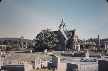 Bendigo Historical Society Inc.
Slide - BENDIGO BUILDINGS & SCENERY, Nov 1960
Slide. Bendigo Buildings & Scenery. Chapel at the Bendigo Cemetery and Burke & Wills Monument at the right.slide, bendigo, bendigo buildings & scenery., bendigo buildings & scenery.