Showing 107 items matching "canterbury maps"
-
 Bendigo Historical Society Inc.
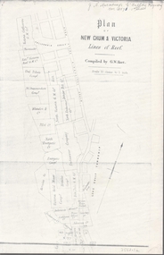
Map - NEW CHUM & VICTORIA LINES OF REEF - PLAN OF NEW CHUM & VICTORIA LINES OF REEF
Two pages of a Plan of New Chum & Victoria Lines of Reef, compiled by G. W. Hart. Taken from J. N. Macartney's G'Fields Registry for 1871. Plan shows leases from High Street to California Gully. Location of the Manchester Arms, British & American Hotel and the Quartz Miners Arms are shown. Townships of Long Gully and Ironbark are shown.map, goldfields, new chum & victoria lines of reef, victoria catharine g m coy, thornton & co, extd victoria reef g m co, ural tribute compy, nil desperandum compy, koch, north victoria g m co, danger hill coy, north endeavour coy, wheadon & co, pilot co, north energetic co, energetic compy, endeavour company, hercules co, victoria gold mines compy, iron duke g m co, golden fleece united, ballerstedt, alfred co, confidence co, prince alfred co, canterbury co, advance co, wells, humboldt co, adventure co, try me well, sterry & co, gibbs & ballerstedt, handy andy, wells?, south adventure co, w rae, victoria reef quartz m co, myra co, jackson, wybrants, burrows & sterry, new chum & victoria tribute, old chum co, ballerstedt, lazarus, watson, koch & hildebrand, lansell & hunt, dennis, abe lincoln co, bonati & co, ellesmere co, moore late menzies, british co, british tribute co, garibaldi, c c co, new chum trib, dobson & co, young chum co, little chum co, old chum co, new chum trib, little chum trib, g w hart, j n macartney's g'fields registry for 1871, manchester arms, british & american, quartz miners arms -
 Ringwood and District Historical Society
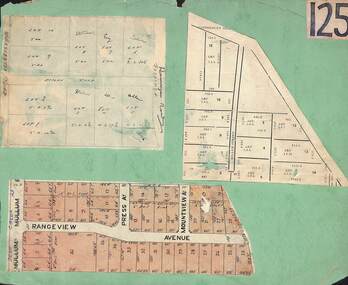
Card, Collage of Residential Subdivision Map Clippings - Ringwood, Victoria - (Undated)
Three maps mounted on green cardboard - Hand-drawn map of residential allotments off Warrandyte Road in Milne Road and Berringa Road Park Orchards. Map with acres roods and perches measurements of allotments in Canterbury Road and Miller Street Heathmont. Clipping from a land sale brochure with street names not existing together in the area - Rangeview Avenue, Press Avenue and Mountview Avenue. -
 Ringwood and District Historical Society
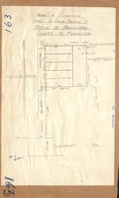
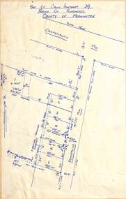
Map - Plan of Subdivision, Part of Crown Portion 7, Parish of Ringwood, County of Mornington - circa 1950
Hand-drawn map attached to light cardboard backing showing 5 residential allotments on eastern side of Maidstone Street Ringwood, north of Canterbury Road.RFK 8/11/51 -
 Ringwood and District Historical Society
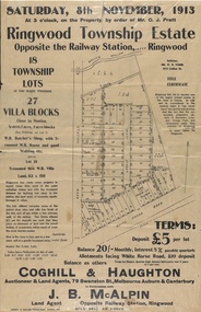
Flyer, Auction Sale Advertisements - Ringwood Township Estate, Ringwood, Victoria - 1913
Advertisements for auction sale of retail and residential blocks opposite the Ringwood Railway Station on Saturday, 8th November, 1913, showing subdivision layout, terms of sale, and summary of local features and services. Auction at 3 o'clock on the property by order of Mr. O.J. Pratt - 18 township lots, 27 villa blocks, also weatherboard butcher's shop with 5-roomed weatherboard house and good stabling, and 5-roomed new weatherboard villa. Subdivision includes Station Road (later Warrandyte Road), Pratt Street, and Whitehorse Road. Agents - Coghill & Haughton, 79 Swanston Street, Melbourne, Auburn & Canterbury, in conjunction with J.B. McAlpin, Opposite Railway Station, Ringwood. Additional 2 partially trimmed copies allotment maps on cardboard backing with handwritten sales notations. -
 Ringwood and District Historical Society
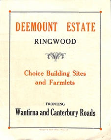
Flyer, Subdivisional Land Sale advertisement - Deemount Estate, Ringwood, Vic. - c.1950
Double sided folded page with black and orange advertisement and blueprint for Deemount Estate fronting Canterbury and Wantirna Roads, Ringwood, with handwritten price list and terms of sale. Additional undated hand-drawn map on light cardboard - 4 allotments on western side of Maidstone Street .Subdivision includes Canterbury Road, Wantirna Road and Maidstone Street. -
 Canterbury History Group
Document - A Victorian Gem - Heritage Report "Arklow"
Heritage Report for "Arklow", 40 Bryson Street, Canterbury - part of Arklow Hill Estate. Report includes information on submission and previous owner Title information11 pages, spinal bound, A4, includes mapsarklow hill estate, heritage studies, bryson street, victorian style -
Canterbury History Group
Ephemera - Historical Walk Canterbury South of the Line and 3 letters, Pam Jellie et al, 1987/8
Walk organised by Canterbury History Group describing 10 sites and a map, 3 letters outlining funding for the walkBlue A4shett folded in 3 and 3 A4 typed letterscanterbury mansions, maling road shops, eurobin, "cullymont", wattle valley road, royal historical society of victoria -
 Ringwood and District Historical Society
Map, Subdivision Plan of residential allotments on Canterbury Road, Bayswater (later surrounding Miller Road, Heathmont), Victoria - (Undated - circa 1930s)
Hand-drawn map on cardboard backing. Includes red pen notations marking allotments sold to Mrs A. Harrison, Mrs C Cornwall, J.M. Miller, and A.W. Dickson.Red pen notations mark allotments sold to Mrs A. Harrison, Mrs C Cornwall, J.M. Miller, and A.W. Dickson. Later subdivision of the map area took in Miller Road and Atunga Court developments. -
 Ringwood and District Historical Society
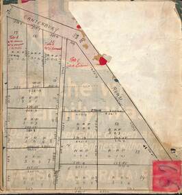
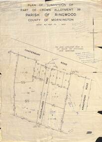
Map - Plan of Subdivision, Part of Crown Allotment 39, Parish of Ringwood, County of Mornington - (Undated - circa 1930s)
Copy of land title map on light cardboard backing showing layout and size of 11 allotments in Canterbury Road and Culverlands Road, Heathmont, Victoria. Hand-written sales notations on map and backing include names and telephone numbers - Mr Robinson MJ2411, Mr Smith MX5425, Abicare WY1848. Later notation 12/12/67 - A. Robertson. Rubber stamp imprint in top left corner - D.H. Oliver, Civil Engineer & Licensed Surveyor, Bellevue Street Lilydale, Phone Lilydale 91. -
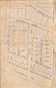
 Ringwood and District Historical Society
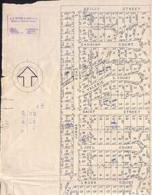
Map, Subdivision Plan of 141 allotments off Jarma Road, Heathmont, Victoria - Circa 1957
Folded subdivision map on cardboard backing with real estate sales notations on some allotments. Subdivision includes Jarma Road, Reilly Street, Adrian Court, Valerie Court, Daisy Street, Joel Court, Ross Court, and Canterbury Road, Heathmont.Rubber stamp imprint in top left corner - J.S. Watson & Associates, Surveyors & Chartered Engineers, 7 Main Street Mornington, Phone Mornington 2186 & 24 Kensington Road, South Yarra, Phone BJ2155. -
 Ringwood and District Historical Society
Map - Plan of Subdivision, Part of Crown Allotment 43, Parish of Ringwood, County of Mornington - (Circa 1950)
Copy of land title map in manilla folder showing layout and size of seven residential allotments (Lots 1 to 4 and 17 to 19) in Canterbury Road Heathmont, north-east of Bedford Road corner.Ronald G. Lee Licensed Surveyor, 195 Bridge Road, Richmond. Tel 42-6356. -
 Ringwood and District Historical Society
Map - Subdivision Plan, Part of Crown Allotment 39, Parish of Ringwood, County of Mornington, Heathmont, Victoria - (Undated - circa 1950s)
Hand-drawn map on light cardboard backing showing location and size of 6 allotments on western side of Armstrong Road near Canterbury Road, Heathmont. -
Canterbury History Group
Document - Maling Road Discovery, 29 October 2011
Document with brief history of Maling Road buildingsInformation gathered by Stuart Warmington for "Visions of a Village" by Don Gibb and Stuart Warmington A4 double-sided typed page and mapmaling road, canterbury theatre, theatre place -
Canterbury History Group
Ephemera - A Golding Walk in Canterbury, Robin Da Costa-Adams, 2006
Walk organised by Robin da Costa-Adams describing 6 sites and a map of area covered by walk. Includes a colour photo of William Tibbitts painting "Canterbury in 1882". A4 sheet folded in landscape with colour photo and mapjohn august reserve, alfred golding, balwyn road, rochester road, balwyn methodist church, chaucers reception centre, "the pines" -
 Ringwood and District Historical Society
Map - Subdivision Plans, Residential allotments in Canterbury Road, Hume Street, Finlayson Street, Gray Street (later Grayview Avenue), and Thomas Street (later Gracedale Avenue), Ringwood East, Victoria - (Undated - circa 1950s)
Hand-drawn map on light cardboard backing. Multiple sets of numbered allotments, with un-numbered lots adjoining a drainage reserve north of Finlayson Street. -
Canterbury History Group
Document, Context Pty Ltd, City of Boroondara, Municipal-Wide Heritage Gap Study: Volume 1 - Canterbury: Final report 23 January 2017, 2017
This report is an assessment for Canterbury's heritage assets (including Victorian, Federation, interwar and post-war dwellings, commercial buildings and precincts). It includes an overview of the methodology, findings and recommendations as well as citations for nominated individual properties and precincts. Appendix D is a detailed study of the places studied.405 pages, A4 in ring binder; includes colour photos, mapsnon-fictionThis report is an assessment for Canterbury's heritage assets (including Victorian, Federation, interwar and post-war dwellings, commercial buildings and precincts). It includes an overview of the methodology, findings and recommendations as well as citations for nominated individual properties and precincts. Appendix D is a detailed study of the places studied.heritage studies, matlock street, mangarra road, chaucer crescent, rochester road, canterbury road -
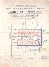 Ringwood and District Historical Society
Map - Plan of Subdivision, Parts of Crown Portions 10 and 10B Parish of Ringwood - 1958
Folded subdivision map of 15 residential allotments in McKay Court Ringwood, off Wantirna Road north of Canterbury Road. Rubber stamped by Surveyors and Chartered Engineers J.S. Watson & Associates, Mornington and South Yarra, with illegible signature dated 17/2/58. Handwritten notations indicating allotment sale names and amounts or where passed in. Accompanying clipping on scrap paper backing from Land Sale Brochure with description of available services and local facilities and terms of sale - £75 Deposit £10 Monthly.