Showing 383 items matching "conservation photographs"
-
 Federation University Historical Collection
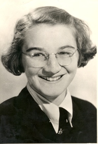
Photograph - Portrait, Valda Lawn (Val D'Angri), c1950
Val Lawn married Norm D'Angri. She later taught Craft at the Ballarat Technical Art School. Val D'Angri is well known for her work on the conservation of the Eureka Flag. Black and white potrait of Ballarat Technical Art School Student Valda Lawn. valda lawn, val d'angri, ballarat technical art school, alumni, university women -
 Conservation Volunteers
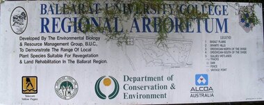
Sign: Ballarat Regional Arboretum, University campus, Mount Helen, Unknown, Ballarat Regional Arboretum Sign, about 1987
Collaboration between ATCV, the local university and corporate and resource manager partners.The arboretum is well grown but is now poorly signed and appears neglected.Large sign-written board next to Ballarat regional Arboretum which is on the slopes above the campus of the University of Ballarat.See photograph attached -
 Conservation Volunteers
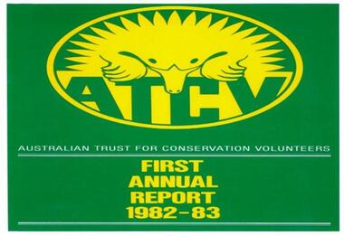
The first-ever ATCV Annual Report 1982-3, ATCV Annual Report 1982-3, 1983
Topics covered:Lists of achievements, officers, benefactors, accounts: priorities for 1983-4; Work featured includes Yarrowee River, Ballarat; Mount Worth; Wilson's Promontory & Port Campbell National Park, Mooramong heritage property,; donattion of first aid boxes by Ballarat School of MinesThis item is significant as it was the first annual report of a then fledgling organisation. It portrays the enthusiasm of board and volunteers to do work for the environment. A4 17PP booklet, black and white printing, 15 b/w photographsGreen and yellow cover featuring 'echidna logo' and text AUSTRALIAN TRUST FOR CONSERVATION VOLUNTEERS - FIRST ANNUAL REPORT 1982-3atcv australian trust for conservation volunteers yarrowee river ballarat mount worth wilsons promontory port campbell - national park - mooramong - first aid - ballarat school of mines -
 Conservation Volunteers
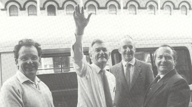
Photograph: Prime Minister Bob Hawke visits Ballarat and meets President of ATCV John Mewton and CEO Tim Cox
Prime Minister Bob HawkeAlthough determinedly apolitical ATCV/CVA has maintained good relations with all sides of politics.Black and white photographcva, conservation volunteers, conservation volunteers australia, conservation volunteers new zealand, colin jackson, better earth, environmental conservation, volunteers, volunteering, corporate volunteering, education – environmental, carbon footprint, climate change, ballarat, safety, training, partnerships, victoria, vic, nsw, queensland, act, australian capital territory, nt, northern territory, western australia, wa, south australia, sa, tasmania, new zealand, californi1a conservation corps, atcv, bob hawke, prime minister, john mewton, tim cox -
 Phillip Island and District Historical Society Inc.
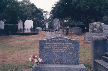
Photograph Album, Kodak, Phillip Island Cemetery, c 1990
The Album was compiled by Nancy McHaffie late 1990's, with the assistance of Edith Jeffery's, with her book "Garden of Memories" and extensive knowledge of Phillip Island. The Cemetery lies back from the road and is surrounded by Manna Gums, rare Peppermint Gums, Blackwoods and other native trees. In all 25 acres of land were set aside as Crown Land in the land settlement of 1868. There are 6.2 acres of wetlands near the cemetery entrance.Jack Robinson Oswin: Many of the trees now flourishing in the cemetery grounds were planted by Jack Oswin and his wife Coral. Born in Mildura in 1909, his association with Phillip Island started when he attended the Cowes Primary School during the war years. He was foundation member of the Phillip Island Conservation Society and played a key role in the purchases of the area of land known as Conservation Hill. In the early 1980s he was awarded the British Empire Medal in recognition for his services to conservation. Jack died on December 4th 1990, aged 81 years.phillip island cemetery, jack robinson oswin, coral oswin, nancy mchaffie, edith jeffery -
 Phillip Island and District Historical Society Inc.
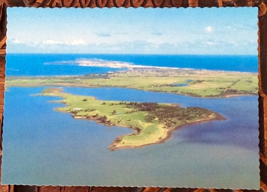
Photographs, Victoria Conservation Trust, Churchill Island, 1980s
... Photographs Victoria Conservation Trust ...3 coloured postcards and 8 coloured photographs of scenes on Churchill Island including an aerial view, homestead, outbuildings, vegetation, views, cairn and coastal scenes.Postcards say Churchill Island, Victoria. Victoria Conservation Trustchurchill island, churchill island heritage farm, churchill island - homestead, samuel amess -
 Greensborough Historical Society
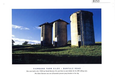
Photograph - Calendar, Banyule City Council, Viewbank Farm silos - Banyule Road, 1997
Colour photograph of Viewbank Farm Silos - Banyule Road. Silos were built in the 1930s by Harold Bartram. He used them to store fodder for his 200 milking cows. A brief history of the site is included. This is taken from the Heidelberg Conservation Study by Graeme Butler.Colour photograph printed in Banyule calendar and information from Heidelberg Conservation Studyviewbank homestead, viewbank silos, harold bartram, banyule road viewbank, viewbank -
 Greensborough Historical Society
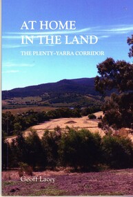
Book, Geoff Lacey, At home in the land: the Plenty-Yarra corridor, 2021
111 p., paperback, col. photographs, mapsnon-fictionindigenous plants, indigenous fauna, plenty river, yarra river -
 Greensborough Historical Society
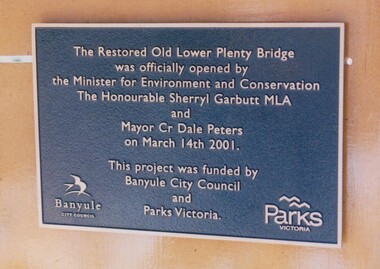
Photograph - Digital Image, Anne Paul, Plaque: Opening of restored Old Lower Plenty Bridge 2001, 14/03/2001
This plaque commemorates the opening of the restored Old Lower Plenty Bridge, opened on 14/03/2001 by the Minister for Environment and Conservation Sherryl Garbutt MLA and Mayor of Banyule Cr Dale Peters. The project was jointly funded by Banyule Council and Parks Victoria.Digital copy of colour photograph of memorial plaquelower plenty, lower plenty bridge, sherryl garbutt, dale peters, banyule council, parks victoria -
 Greensborough Historical Society
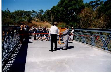
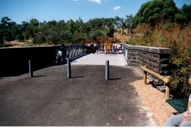
Photograph - Digital Image, Anne Paul, Opening of restored Old Lower Plenty Bridge 2001, 14/03/2001
The opening of the restored Old Lower Plenty Bridge, opened on 14/03/2001 by the Minister for Environment and Conservation Sherryl Garbutt MLA and Mayor of Banyule Cr Dale Peters. The project was jointly funded by Banyule Council and Parks Victoria. The restored bridge is the oldest remaining bridge in the former Shire of Eltham and forms part of the Plenty River Trail.Digital copy of colour photographlower plenty, lower plenty bridge, sherryl garbutt, dale peters, banyule council, parks victoria -
 Greensborough Historical Society
Photograph - Digital Image, Anne Paul, Opening of restored Old Lower Plenty Bridge 2001 - area adjacent, 14/03/2001
The opening of the restored Old Lower Plenty Bridge, opened on 14/03/2001 by the Minister for Environment and Conservation Sherryl Garbutt MLA and Mayor of Banyule Cr Dale Peters. The project was jointly funded by Banyule Council and Parks Victoria. The restored bridge is the oldest remaining bridge in Nillumbik and forms part of the Plenty River Trail. this photograph shows the area adjacent to the bridge on the day of the opening.Digital copy of colour photographlower plenty, lower plenty bridge, sherryl garbutt, dale peters, banyule council, parks victoria -
 Greensborough Historical Society
Photograph - Digital Image, Anne Paul, Opening of restored Old Lower Plenty Bridge 2001 - bridge and community, 14/03/2001
The opening of the restored Old Lower Plenty Bridge, opened on 14/03/2001 by the Minister for Environment and Conservation Sherryl Garbutt MLA and Mayor of Banyule Cr Dale Peters. The project was jointly funded by Banyule Council and Parks Victoria. The restored bridge is the oldest remaining bridge in the former Shire of Eltham and forms part of the Plenty River Trail. This photograph shows the bridge area ready for the opening ceremony and the assembled community members attending the function.Digital copy of colour photographlower plenty, lower plenty bridge, sherryl garbutt, dale peters, banyule council, parks victoria -
 Greensborough Historical Society
Photograph - Digital Image, Anne Paul, Opening of restored Old Lower Plenty Bridge 2001 - side view of bridge, 14/03/2001
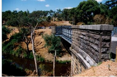
The opening of the restored Old Lower Plenty Bridge, opened on 14/03/2001 by the Minister for Environment and Conservation Sherryl Garbutt MLA and Mayor of Banyule Cr Dale Peters. The project was jointly funded by Banyule Council and Parks Victoria. The restored bridge is the oldest remaining bridge in the former Shire of Eltham and forms part of the Plenty River Trail. This photograph shows the bridge from the side elevation, showing the bluestone and iron construction.Digital copy of colour photographlower plenty, lower plenty bridge, sherryl garbutt, dale peters, banyule council, parks victoria -
 Greensborough Historical Society
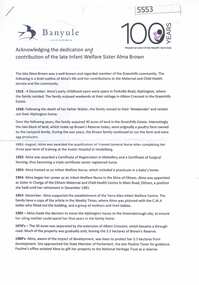
Article, Acknowledging the dedication and contribution of the late Infant Welfare Sister Alma Brown, 1916o
Chronology of Alama Brown's life, work in maternal and child health in the Diamond Valley area and conservation, memorialised by Brown's Reserve in Greenhills. Also a celebration of 100 years of Maternal and Child Health.4p. col. documents, photographsalma brown, infant welfare -
 Glenelg Shire Council Cultural Collection
Photograph - Photograph - Montage. Handover Ceremony of Portland Section of Great South West Walk to Department Conservation Forrest and Land, 13/04/1986
... to Depatment,Conservation, Forests and Lands following inaugurul walk ...Glenelg Shire Council RecordsPhotographic Montage of handing over of Portland section of Great South West Walk, to the Department Conservation, Forests and Lands.Front: Bottom Right: Sticker, typed Handing over to Depatment,Conservation, Forests and Lands following inaugurul walk on City of Portland Section of the Great South West Walk. (now a complete circuit) Signature in pen Grahame McDonald 13th April 1986. -
 Kiewa Valley Historical Society
Posters - 5 in series - Published by the Victorian Conservation Trust 1980
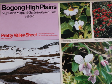
... There are 4 sheets - Hotham not photographed. The Victoria... but not photographed. The Spion Kopje Sheet is not included. The Victoria ...Series of five includes: Bogong High Plains - Pretty Valley Sheet, Rocky Valley Sheet and Bogong Sheet. The Hotham Sheet is in the tube but not photographed. The Spion Kopje Sheet is not included. The Victoria Conservation Trust published the posters in 1980Bogong High PlainsThere are 4 sheets - Hotham not photographed. The Victoria Conservation Trust published this series of the Bogong High Plains in 1980. All coloured, glossy and two sided.flora and fauna, bogong high plains, victoria conservation trust -
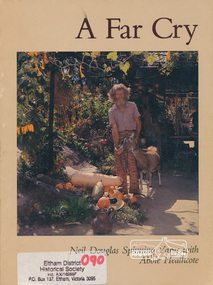 Eltham District Historical Society Inc
Book, Neil Douglas et al, A far cry / Neil Douglas spinning yarns with Abbie Heathcote, 1979
Reminiscences of environmental artist Neil Douglas as told to Abbie Heathcote. Kangaroo Island stories, living naturally, bumbling through the Depression, Robinson Crusoe gardening, trials of a conservationist, health and home, artist friends, aninal friends. Illustrated by Neil Douglas and incudes photographs of his home and garden at Bend of Islands.1. Paperback; 140 p. : ill. ; 25 cm. 2. Hardback (missing dust jacket); 140 p. : ill. ; 25 cm.ISBN 095950950xstories, social customs, alternative lifestyles, kangaroo ground, gardening, reminiscences, bend of islands, conservation, neil douglas, abbie heathcote, environment, -
 Eltham District Historical Society Inc
Photograph, Eucalyptus Road and Pitt Street/Nyora Road roundabout, Eltham
... pauline toner butterfly nature conservation reserve Colour ...Looking north along Eucalyptus Road, showing roundabout at intersection of Pitt Street and Nyora Road, Eltham. Parks Victoria owns and manages the Pauline Toner Eltham Copper Butterfly Reserve on the left of the image. Colour photographeucalyptus road, pitt street, nyora road, roundabouts, eltham, pauline toner eltham copper butterfly reserve, pauline toner butterfly nature conservation reserve -
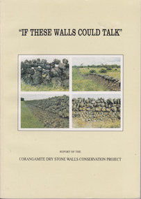 Warrnambool and District Historical Society Inc.
Book, If These Walls Could Talk, 1995
This publication is a result of funding made to the Corangamite Arts Council in 1990-91. Its aims were to identify and research the dry stone walls of the region, to raise their profile and through workshops continue the skills of those wanting to learn more about the craft. The book gives the history of the practice in the area and the various different styles with photographs to illustrate the different features. It also has a number of first- hand accounts written by stonewallers.This study has social, historical, artistic and interpretive significance as the walls are an important feature of the district. The account written by former builders of the walls provides an interesting insight into the various styles and reasons for their construction.Light green card cover. Front cover has 4 photographs of dry stone walls with title and other text in black. Back cover is plain. 144 pages. It contains a large number of black and white photographs of stone walls from around the district as well as maps. Report of the Corangamite dry stone walls Conservation project.dry stone walls, corangamite stone walls, warrnambool and district history, constructing dry stone walls -
 Warrnambool and District Historical Society Inc.
Book, Warrnambool Botanic Garden Masterplan, February 1995
This Warrnambool Botanic Gardens Study and Report was funded by the National Estate Grants Program of the Australian Heritage Commission and the City of Warrnambool. It was monitored in progress by a Steering Committee consisting of representatives of the Botanic and Public Gardens Advisory Committee, the Warrnambool City Council, Friends of the Warrnambool Botanic Gardens and National Estate Grants Program representatives and community representatives. The Warrnambool Botanic Gardens were first sited close to the Hopkins River in 1859. In 1869 the gardens were relocated to the present day location in Botanic Road. This plan is of some importance as it gives an overview of the history and current condition in 1995 of the Warrnambool Botanic Gardens and draws up a plan for its future development. It is useful for research and for consideration by the City Council today of policy making and further development of the gardens. This is a publication containing a master plan for the Warrnambool Botanic Gardens. It has a section on acknowledgements, a summary, eight chapters, and 14 appendices. The pages are bound with plastic rings, the front cover is plasticized with an aerial photograph of the Botanic Gardens and surrounds and the back cover is lightweight cardboard. The pages contain printed material, fold out maps, sketches and diagrams and many photocopied photographs.Front Cover: City of Warrnambool, Warrnambool Botanic Gardens, Conservation and Development Plan, Jill Orr-Young, Patrick Mallon, SF Consultants Pty Ltd, February 1995. warrnambool botanic gardens, warrnambool -
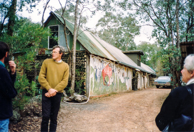 Eltham District Historical Society Inc
Photograph, Visit to Clifton Pugh's home, Dunmoochin, 26 May 1991, 26/05/1991
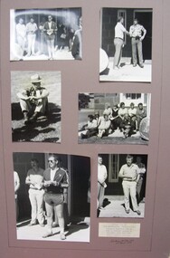
[from EDHS Newsletter No. 78, May 1991:] DUNMOOCHIN TRIP "Dunmoochin" was the home of the famous artist Clifton Pugh who died last year. The house also gives an informal name to the surrounding area at Cottles Bridge where artists, conservationists and like minded people have made their homes. This is an area of unconventional houses blending in with the surrounding bushland. The Pugh house is a rambling complex including studios and a large pottery kiln. It contains many of Clifton Pugh's works. For this excursion we have arranged a guided visit of the Pugh house and hope to be able to visit another house in the area. We will also be able to wander through bushland which Clifton had purchased for conservation purposes. This will be an afternoon excursion on Sunday 26th May starting with lunch (bring your own) at 12:30 pm at the Panton Hill Memorial Park. Transport will be by private car but transport can be arranged for those not wishing to drive. There is no cost but we need to be advised of members attending. Advise Russell Yeoman at the May Meeting or by 10th May if you intend to go. We will not be able to add extra people after that date.Three colour photographsactivities, clifton pugh, dunmoochin -
 Eltham District Historical Society Inc
Photograph, Leon Saper residence, 60 Dunmoochin Road, Cottlesbridge, 26 May 1991, 26/05/1991
[from EDHS Newsletter No. 78, May 1991:] DUNMOOCHIN TRIP "Dunmoochin" was the home of the famous artist Clifton Pugh who died last year. The house also gives an informal name to the surrounding area at Cottles Bridge where artists, conservationists and like minded people have made their homes. This is an area of unconventional houses blending in with the surrounding bushland. The Pugh house is a rambling complex including studios and a large pottery kiln. It contains many of Clifton Pugh's works. For this excursion we have arranged a guided visit of the Pugh house and hope to be able to visit another house in the area. We will also be able to wander through bushland which Clifton had purchased for conservation purposes. This will be an afternoon excursion on Sunday 26th May starting with lunch (bring your own) at 12:30 pm at the Panton Hill Memorial Park. Transport will be by private car but transport can be arranged for those not wishing to drive. There is no cost but we need to be advised of members attending. Advise Russell Yeoman at the May Meeting or by 10th May if you intend to go. We will not be able to add extra people after that date.Two colour photographsactivities, clifton pugh, dunmoochin, leon saper -
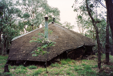
 Eltham District Historical Society Inc
Photograph, Doug Orford, Pottery kiln, visit to Clifton Pugh's home, Dunmoochin, 26 May 1991, 26/05/1991
[from EDHS Newsletter No. 78, May 1991:] DUNMOOCHIN TRIP "Dunmoochin" was the home of the famous artist Clifton Pugh who died last year. The house also gives an informal name to the surrounding area at Cottles Bridge where artists, conservationists and like minded people have made their homes. This is an area of unconventional houses blending in with the surrounding bushland. The Pugh house is a rambling complex including studios and a large pottery kiln. It contains many of Clifton Pugh's works. For this excursion we have arranged a guided visit of the Pugh house and hope to be able to visit another house in the area. We will also be able to wander through bushland which Clifton had purchased for conservation purposes. This will be an afternoon excursion on Sunday 26th May starting with lunch (bring your own) at 12:30 pm at the Panton Hill Memorial Park. Transport will be by private car but transport can be arranged for those not wishing to drive. There is no cost but we need to be advised of members attending. Advise Russell Yeoman at the May Meeting or by 10th May if you intend to go. We will not be able to add extra people after that date.Colour photographactivities, clifton pugh, dunmoochin -
 Eltham District Historical Society Inc
Photograph, Visit to Clifton Pugh's home, Dunmoochin, 26 May 1991, 26/05/1991
[from EDHS Newsletter No. 78, May 1991:] DUNMOOCHIN TRIP "Dunmoochin" was the home of the famous artist Clifton Pugh who died last year. The house also gives an informal name to the surrounding area at Cottles Bridge where artists, conservationists and like minded people have made their homes. This is an area of unconventional houses blending in with the surrounding bushland. The Pugh house is a rambling complex including studios and a large pottery kiln. It contains many of Clifton Pugh's works. For this excursion we have arranged a guided visit of the Pugh house and hope to be able to visit another house in the area. We will also be able to wander through bushland which Clifton had purchased for conservation purposes. This will be an afternoon excursion on Sunday 26th May starting with lunch (bring your own) at 12:30 pm at the Panton Hill Memorial Park. Transport will be by private car but transport can be arranged for those not wishing to drive. There is no cost but we need to be advised of members attending. Advise Russell Yeoman at the May Meeting or by 10th May if you intend to go. We will not be able to add extra people after that date.Three colour photographsactivities, clifton pugh, dunmoochin -
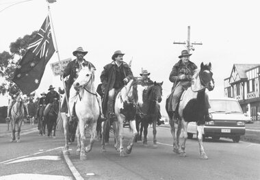 Ringwood and District Historical Society
Photograph, Horsemen at Nunawading By-election 1982
Written on back of photograph, "Dec. 1985 at vote for Nunawading by-election side issues ???, such as conservation of high country". -
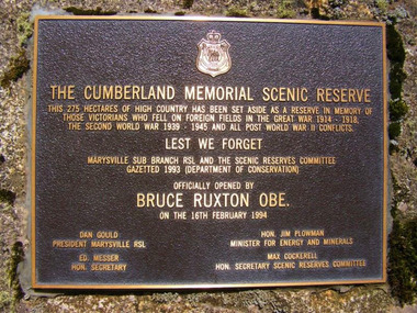 Marysville & District Historical Society
Photograph (item) - Colour photograph, Unknown
A colour photograph of the plaque commemorating Victorian veterans who have lost their lives in various conflicts in world history which was placed in the Cumberland Memorial Scenic Reserve on 16th February 1994, the day of the opening of the reserve.The Cumberland Memorial Scenic Reserve comprises of 275 hectares set aside as a reserve to commemorate Victorians who have died in service or were killed in action in World War One, World War Two, and conflicts since 1945. The reserve is situated on the Marysville-Wood's Point Road.THE CUMBERLAND MEMORIAL SCENIC RESERVE THIS 275 HECTARES OF HIGH COUNTRY HAS BEEN SET ASIDE AS A RESERVE IN MEMORY OF/ THOSE VICTORIANS WHO FELL ON FOREIGN FIELDS IN THE GREAT WAR 1914 - 1918,/ THE SECOND WORLD WAR 1939 - 1945 AND ALL POST WAR II CONFLICTS LEST WE FORGET MARYSVILLE SUB BRANCH RSL AND THE SCENIC RESERVES COMMITTEE GAZETTED 1993 (DEPARTMENT OF CONSERVATION) OFFICIALLY OPENED BY BRUCE RUXTON OBE. ON THE 16TH FEBRUARY 1994 DAN GOULD/ PRESIDENT MARYSVILLE RSL ED MESSER/ HON SECRETARY HON. JIM PLOWMAN/ MINISTER FOR ENERGY AND MINERALS MAX COCKERERLL/ HON. SECRETARY SCENIC RESERVES COMMITTEEcumberland memorial scenic reserve, marysville, victoria, marysville-woods point road -
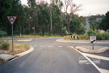
 Eltham District Historical Society Inc
Photograph, Eucalyptus Road, Eltham, 15 October 1990
Looking south towards Pitt Street and Nyora Road. Bus stop now on opposite side. Pauline Toner Butterfly Nature Conservation Reserve managed by Parks Victoria on the right hand side. Roll of 35mm colour negative film, 6 of 7 stripsKodak Gold 100-2 5095infrastructure, roadworks - gutters, shire of eltham, streets, eucalyptus road, pauline toner eltham copper butterfly reserve, pauline toner butterfly nature conservation reserve -
 Eltham District Historical Society Inc
Photograph, Eucalyptus Road and Pitt Street/Nyora Road roundabout, Eltham
Looking north along Eucalyptus Road, showing roundabout at intersection of Pitt Street and Nyora Road, Eltham. Parks Victoria owns and manages the Pauline Toner Eltham Copper Butterfly Reserve on the left of the image.Roll of 35mm colour negative film, 4 stripsFuji 100eltham, eucalyptus road, nyora road, pitt street, roundabouts, pauline toner eltham copper butterfly reserve, pauline toner buttefly nature conservation reserve -
 Glen Eira Historical Society
Document - Church of Christ Caulfield North Dandenong Road 514
Reprinted conservation study on Church of Christ by Andrew Ward dated March 1995 of 514 Dandenong Road. Includes black and white photo and black and white undated photo of Church of Christ. Printout from website on Indonesian Praise Centre formerly Church of Christ North Caulfield includes a coloured photograph.ward andrew, dandenong road, north caulfield, gothic revival architecture, towers, religious groups, romanesque style, alma road, lloyd c, yanga, architecture, goldsworthy stanley, architects, deague brothers, williams and sons, iskander hendra, budiman agus, jayo yanta, margono haryono, indonesian praise centre, oikumene evangelical charismatic church -
 Glen Eira Historical Society
Article - CAULFIELD RAILWAY STATION
This file contains four items: 1/Press cutting from Caulfield Contact, November 1991 (brief report, with photograph of Caulfield Station passengers boarding the steam engine K163 bound for Frankston on Public Transport Open Day). 2/Five pages (stapled together) of photo copied recommendations and assessment by Andrew Ward, March 1995, relating to the history, condition and conservation of the Caulfield Railway Station complex (includes four photocopied photographs). 3/Six pages (stapled together) of material from Heritage Victoria, to B. Evans, Environment Offices, Bayside Trains, 05/03/1999 (two sheets), with enclosure (4 sheets) relating to the cultural heritage significance of the Caulfield Railway Station complex (includes one photocopied photograph). 4/Photocopy of postcard (gelatin silver photograph) of ‘Three new railway lines, train going to Oakleigh [at Caulfield Railway Station]’ c1915, from State Library of Victoria (print dated 12/06/2013).caulfield railway station, b. evans, steam engines, railway stations, railway buildings, ray tonkin, heritage victoria, andrew ward