Showing 121 items
matching council vehicles
-
 Bendigo Historical Society Inc.
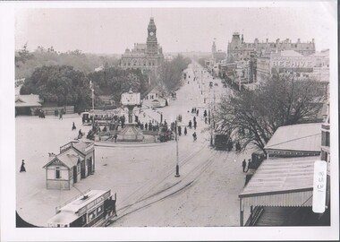
Photograph - Charing Cross and Pall Mall
View of Charing Cross and Pall Mall Bendigo, featuring the Alexandra fountain still under construction. The fountain was jointly funded by the Bendigo Juvenile Industrial Exhibition in 1879, a 500 pound donation by George Lansell and a 700 pound grant from the Sandhurst City Council. The fountain was designed by William Vahland and was opened 5/7/1881. The fountain is 28 feet tall and sits in a 2 feet deep pond that is 50 feet in diameter. It was built with 22 tons of Harcourt granite, cast iron and painted stone.8531 A4 B&W photograph of Charing Cross and Pall Mall, Bendigo, in the late 1800s (prior to automobiles); taken from the City Family Hotel. Photograph shows work underway on the Alexandra Fountain at Charing Cross. Photo shows three trams, pedestrians and some horse drawn vehicles. Pall mall shows Post Office, Shamrock hotel and TAFE towers.charing cross, post office -
 Kew Historical Society Inc
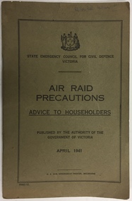
Booklet, State Emergency Council for Civil Defence, Air Raid Precautions: Advice to Householders, 1941
Air raid precautions distributed to householders in Victoria. The booklet is part of a suite of materials used to support Air Raid Precautions (ARP) during the Second World War. Air raid wardens managed groups of people in using air raid facilities that were constructed throughout the district. The ARP scheme was based on that developed in the United Kingdom.Primary resources showing the materials and advice developed to protect civilians on the home front. Examples of such support in the Kew Historical Society's collection includes advice for authorised community representatives, insignia and equipment.This booklet was published by the State Emergency Council for Civil Defence Victoria in April 1941. The 37-page work provides advice about what to do in an air raid, lighting restrictions, the use of road vehicles and safety for pedestrians, and shelters. The final pages of the book include a number of illustrations providing guidelines for air raid shelter construction. second world war - air raid precautions, state emergency council for civil defence victoria - 1939-45, arp, air raid precautions, second world war — air raid precautions, state emergency council for civil defence victoria — 1939-1945, world war 2 — 1939-1945, home front — kew (vic.) -
 Kew Historical Society Inc
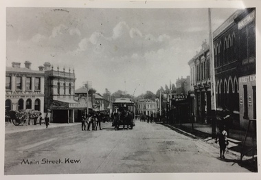
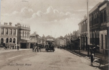
Postcard, Main Street, Kew
Image copied from older postcard (c.1890-1900) showing horse drawn vehicles and a horse tram. Since then, the southern side of the street has been widened. Businesses identified in the photograph include the Ryan's Council Family Hotel, the Greyhound Hotel, the Clifton Hotel, the ES&A Bank and Jellis' Bakery. Black & white photograph of a postcard showing Main [High] Street, Kew looking south west showing horse drawn tram centre.Reverse - "High St Kew looking down from Post Office to Kew Junction"horse tram kew, clifton hotel - kew junction, ryan's council family hotel kew, horse tram - kew (vic), kew junction -
 Kew Historical Society Inc
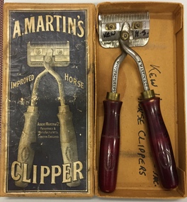
Equipment, A Martin's Improved Horse Clipper
Horse drawn vehicles were used by the City of Kew to draw a number of vehicles including garbage carts. These clippers were used to groom council-owned horses. A well-provenaced piece of equipment used to groom council-owned horses. The item has local significance as a representative piece of equipment made redundant by the introduction of motorised vehicles.Metal horse clippers with wooden handles of a red colour. Manufacturers label on box : "A. Martin's Improved Horse Clipper : Albert Martin & Co., Patentees and Manufacturers, London, England" Similar manufacturer's markings on handles of the clipper. The box notes that it was sourced from the City of Kew.horse clippers, city of kew -
 Kew Historical Society Inc
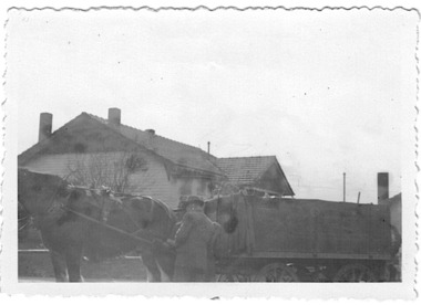
Photograph - Rubbish cart of the City of Kew, 1935-1945
... of kew council workers horse-drawn vehicles kew depot Annotation ...The City of Kew (1860-1994) was a municipality within the boundaries of suburban Melbourne, bordering on the inner suburbs. It was governed by a Council who employed council officers and workers. Services offered to ratepayers included garbage collection. Workers also carried our rubbish removal. From the evidence of photographs, garbage trucks has a semi-circular top with openings on the side of the top and at the rear. Rubbish carts were simple open top containers. Both garbage trucks and rubbish carts were drawn by horses and, in the interwar years and after, operated out of the Council Depot in High Street (formerly the 'horse tramway' sheds and later was to be replaced by the Kew Recreation Centre. The depot was on the corner of High and Disraeli Streets, kew. Small, original black and white positive photograph of a council worker, horse and rubbish cart. This rectangular cart has an open top. An unidentified house is in the background.Annotation in pencil by donor verso: "Kew Council Rubbish cart / Pre & during WWII / from Eliz Bentley"rubbish collection, garbage collection, rubbish carts, city of kew, council workers, horse-drawn vehicles, kew depot -
 Kew Historical Society Inc
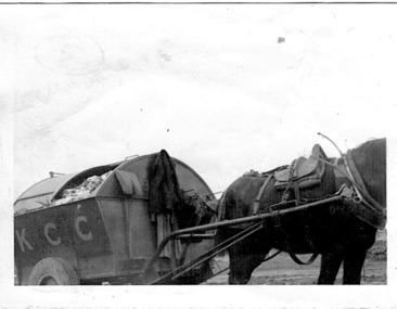
Photograph - City of Kew garbage truck, 1935-1945
... of kew council workers horse-drawn vehicles kew depot Annotation ...The City of Kew (1860-1994) was a municipality within the boundaries of suburban Melbourne, bordering on the inner suburbs. It was governed by a Council who employed council officers and workers. Services offered to ratepayers included garbage collection. Workers also carried our rubbish removal. From the evidence of photographs, garbage trucks has a semi-circular top with openings on the side of the top and at the rear. Rubbish carts were simple open top containers. Both garbage trucks and rubbish carts were drawn by horses and, in the interwar years and after, operated out of the Council Depot in High Street (formerly the 'horse tramway' sheds and later was to be replaced by the Kew Recreation Centre. The depot was on the corner of High and Disraeli Streets, kew. Small, original black and white positive photograph of a City of Kew horse and garbage cart. The rectangular cart has a curved roof with openings at the side. A large door at the back allowed for the removal of garbage. K.C.C. is written on the side of the cart.Annotation in pencil by donor verso: "From E. Bennett / Kew City C'cil used during and after WW2 / from E. Bentley"rubbish collection, garbage collection, rubbish carts, city of kew, council workers, horse-drawn vehicles, kew depot -
 Kew Historical Society Inc
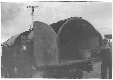
Photograph - City of Kew garbage cart, 1935-1945
... of kew council workers horse-drawn vehicles kew depot Annotation ...The City of Kew (1860-1994) was a municipality within the boundaries of suburban Melbourne, bordering on the inner suburbs. It was governed by a Council who employed council officers and workers. Services offered to ratepayers included garbage collection. Workers also carried our rubbish removal. From the evidence of photographs, garbage trucks has a semi-circular top with openings on the side of the top and at the rear. Rubbish carts were simple open top containers. Both garbage trucks and rubbish carts were drawn by horses and, in the interwar years and after, operated out of the Council Depot in High Street (formerly the 'horse tramway' sheds and later was to be replaced by the Kew Recreation Centre. The depot was on the corner of High and Disraeli Streets, kew. Small, original black and white positive photograph of a City of Kew garbage cart and two council workers. The rectangular cart has a curved roof with openings at the side. A large door at the back allowed for the removal of garbage. Annotation in pencil by donor verso: "From E. Bentley / used during and after WW2 / Kew Garbage Truck"rubbish collection, garbage collection, rubbish carts, city of kew, council workers, horse-drawn vehicles, kew depot -
 Kew Historical Society Inc
Photograph - Filling in the Outer Circle Railway cutting at East Kew, 1939
W.D. Vaughan (Kew's Civic Century, 1960, pp.195-6) quotes Council Minutes of 1938 and 1939 to record that: "After protracted negotiations between the Council, the Railways Department and the Tramways Board agreement was reached in June, 1938, for the filling of the railway cutting at the Harp Junction and shifting tram tracks to the High Street alignment ... The Outer Circle railway land from Princess Street to Park Crescent was purchased by the Kew Council in October, 1939, for 2,750 [pounds]. The land from Park Crescent to High Street was leased for 1 [pound] per annum. Considerable work was done in levelling the embankments to the original surface level."Important and rare photograph of the period, showing major works by Kew Council in Kew East working on a significant piece of urban infrastructure.Small, original black and white positive (photograph) showing workers and vehicles filling in the tracks of the former Outer Circle railway at East Kew. In the background is the metal bridge with brick piers, adjacent to the Harp Junction. The bridge crossed the cutting, linking the two parts of High Street. Behind the tip truck, painted on the side with the name 'Fowler Quarries' [located Keilor Road, North Essendon], one can see shops [including T.G. Garroway, Cash Grocer] in High Street. What appears to be the City of Kew Steamroller is immediately in front of the bridge. A group of passers-by watch from the bridge and from the road. Annotation in pencil on verso: "Filling in Outer Circle line at High St East Kew prior to straightening High St. (c. Feb 1930?)outer circle railway, railway cuttings, harp junction, high street -- kew east -
 Kew Historical Society Inc
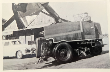
Photograph - City of Kew vehicles and workers, c. 1960
Tom Bentley (1912-1993) was born in Lancashire (UK). From circa 1951, he was the Overseer/Superintendent of Outdoor Works for Kew City Council. Until his retirement in the 1970s, he was based at the Kew Council Depot, located in the former MTB Horse Tram Depot on the corner of Disraeli and High Streets, Kew. Accompanying the set of twelve photographs is a 12-page illustrated biography of the Bentley and Plumridge families, separately kept in the 'Bentley' subject file.Duplicate black and white positive print photograph of road works in Studley Park Road, Kew, carried out under the supervision of Tom Bentley, Overseer/Superintendent of Outdoor Works for the City of Kew. The photograph shows a Council-owned front end loader and a Council trailer.city of kew, public works, tom bentley -
 Kew Historical Society Inc
Postcard, Main Street, Kew, c.1890
The Kew Historical Society's Pictures Collection is comprised of photographs, postcards and original works of art. The postcards include original (mainly) images dating from the 1900s to the present. A number of postcards, some of which have numerous variants, were published as parts of series. Others are original images customised as postcards. Many of the postcards in the collection depict places within the suburbs of Kew and Kew East. Others depict locations in Victoria or internationally. A monochrome postcard showing Main Street [High Street], Kew, looking south west from near its junction with Cotham Road, showing: Ryan’s Council Family Hotel, T. G. Jellis (baker, confectioner), Herbert King (undertaker), L. Merritt (boot warehouse), horse tram, horse drawn vehicles and pedestrians.Post card text addressed to Miss Newell of Balmain.high street - kew, cotham road - kew, tramways - kew -
 Kew Historical Society Inc
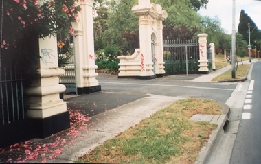
Photograph - Gates, Victoria Park, 1988
The Kew Asylum Entrance Gateway and an adjacent gate lodge were built at the Princess Street entrance in 1873.1 The imposing sandstone pillars and cast-iron gates impressed upon visitors the therapeutic and civilising vision of the asylum. The entrance opened onto a tree-lined drive (now known as Main Drive) which culminated in an elliptical carriageway in front of the main building. (Heritage Council of Victoria)Colour photographic positive of the former Kew Asylum Gates which were relocated in 1942 to Victoria Park in High Street, Kew. The gates were listed by Heritage Victoria in 2020. The citation reads: "The Former Kew Asylum Entrance Gateway consists of two 4.5 metre sandstone gate piers on bluestone bases on either side of a 5.5 metre vehicle entrance set back from the High Street pavement. The 1870s gate piers are of Barrabool sandstone and repairs during 2015-16 were undertaken with sandstone from English Town, Tasmania. The gate piers are highly decorative and feature oculi, triglyphs, dentils, corbeling and other ornamental work. Each gate pier incorporates a pedestrian archway with a cast-iron pedestrian swing gate. Two curved sections of cast-iron palisade fencing on rusticated bluestone blocks extend from the outer edges of the piers to a set of shorter sandstone pillars on the High Street pavement. Straight sections of cast-iron fence extend 4.5 metres ending at two bluestone pillars. Garden beds have been created within the curved sections of fencing, bordered by concreted bluestone and planted with shrubs." (Heritage Council of Victoria)gates -- kew asylum, gates -- victoria park -- kew (vic.) -
 Royal District Nursing Service (now known as Bolton Clarke)
Photograph - Photograph, black and white, Barry Sutton, 24.06.1971
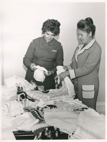
RDNS Sister E. Anderson is Supervisor of Royal District Nursing Service (RDNS) Footscray Centre and Mrs. J. Simpson is the coordinator of RDNS Auxiliaries. They are admiring items from auxiliaries and other interested friends which will be distributed, as required, by RDNS Sisters to any poor families whom they visit to administer nursing care.From its inception in 1885 Melbourne District Nursing Society (MDNS), held functions to gain finances to run the Society. They also asked the public for donations, ranging from food items to linen for bandages, bed linen, blankets, clothes, including baby clothes, etc to assist in the care of their patients. The public generously responded. Each year the President made a special appeal for donations at Christmas time for food and gifts for the MDNS sick poor. Out of this evolved, in 1925, the first MDNS Auxiliary in the Eastern Suburbs. This extended to Auxiliaries throughout the suburbs who worked to donate money and ‘gifts in kind’ to assist MDNS to continue their work, and to furnish wards in the After-Care Home. Before the District Division of MDNS had its own fleet of vehicles, a Motor Auxiliary was formed in 1929 where the general public, when available, provided their car, and drove Sisters to visit patients who lived a distance away. This was disbanded in 1971 when the, now named Royal District Nursing Service (RDNS), had its own fleet of vehicles. The Jessie Henderson Auxiliary ran a Kiosk and Library with all profits to the Society for 20 years. By 1950 there were fourteen auxiliaries who continued to hold functions when the District division separated from the After-Care Hospital and became Melbourne District Nursing Service, which, with Royal patronage, became RDNS in 1966. A Council of Auxiliaries, with Mrs. J. Simpson at its head, and which comprised of two delegates from each auxiliary, was formed in February 1968 to work for District. There were nine auxiliaries in 1970. They continued to run into the 2000s, but the numbers of auxiliaries reduced over the years, as well as the number of members in each auxiliary as the members aged, so this form of support ceased.On the rear left of the black and white photograph is Royal District Nursing Service (RDNS), Sister E. Anderson, who has short dark curly hair and is wearing her RDNS uniform of a long sleeved grey frock, with a white name badge on the upper left; parts of RDNS insignia are seen on the top section of each sleeve. On the right rear is Mrs. J. Simpson, who has her long dark hair drawn up and is wearing a light grey coloured frock with white lapels, cuffs and a white pocket, all with dark piping. They are both holding baby items and looking at knitted and other donated items which are laying on tables in front of them.Photographers stamp. Quote No. KH 74melbourne district nursing society, melbourne district nursing service, mdns, royal district nursing service, rdns, mdns auxiliaries, rdns auxiliaries, ellen anderson,, j. simpson, -
 Tarnagulla History Archive
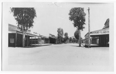
Photograph looking up Commercial Road, Tarnagulla, Looking up Commercial Road, Tarnagulla, c.1960s
Murray Comrie Collection. Original print.Monochrome photograph. View looking up Commercial Road, Tarnagulla, from the Poverty Street intersection. Street deserted - no people or vehicles visible. Building with text 'Williams & Clouston's' visible at far right. Willersdorf;s store opposite, and the Borough Council Chambers can vaguely be seen in the left distance. tarnagulla, businesses, commercial road -
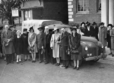 City of Kingston
Photograph - Black and white, c.1943
This photograph shows members of the community outside the Moorabbin Council Offices, handing over a brand-new utility truck for use by the Australian Comforts Fund, in support of the war effort. It was purchased with funds raised by contestants in Moorabbin's 'Popular Girl Quest'. Contestants received a vote for each penny they collected. The winner was Gladys Mariott, pictured centre wearing a sash, who raised £528 10s, earning her 126,800 votes. In total, the contestants raised more than a thousand pounds, which enabled the purchasing of the new utility truck.Members of the Moorabbin community were keen to play their part in supporting the war effort. A black and white photograph of a group of men and women standing in front of and behind a utility vehicle with the license plate FA 341. There are two buildings in the background, one of which has a sign out the front that reads "Moorabbin Free Library & Mechanics Institute". The photograph was taken outside Moorabbin Council offices to illustrate the handing over of utility truck for use by Australian Comforts Fund. Money for the truck was raised by the 'Popular Girl Quest' won by Gladys Marriott (centre wearing sash)Handwritten in red ink: A 600 / 72% Handwritten in black ink: CHAP 6. / WITH SUB-STORY / Spy base -- / OR general pix / in Chap 6 / referring to warworld war ii, australian comforts fund, popular girl quest, fundraising, war efforts, vehicles -
 Merri-bek City Council
Photograph - Archival inkjet print, Janelle Low, Untitled #1, 2016
“Maybe here” is a constant thought running through the back of my mind that something might happen where I’m standing. Tension builds at the slightest sound or suggestion of movement. How much of this fear is self-perpetuated and how much of it is warranted. How different would my experience be if I was someone else.This series is a departure from Janelle Low’s conceptual interests around Australian identity and multiculturalism. Using the project as a vehicle to confront and challenge her own personal concerns as well as a means to represent a more universal female experience.Donated by the artist -
 Merri-bek City Council
Photograph - Archival inkjet print, Janelle Low, Untitled 8, 2016
“Maybe here” is a constant thought running through the back of my mind that something might happen where I’m standing. Tension builds at the slightest sound or suggestion of movement. How much of this fear is self-perpetuated and how much of it is warranted. How different would my experience be if I was someone else.This series is a departure from Janelle’s conceptual interests around Australian identity and multiculturalism. Using the project as a vehicle to confront and challenge her own personal concerns as well as a means to represent a more universal female experience. -
 Merri-bek City Council
Photograph - Archival inkjet print, Janelle Low, Untitled #9, 2016
“Maybe here” is a constant thought running through the back of my mind that something might happen where I’m standing. Tension builds at the slightest sound or suggestion of movement. How much of this fear is self-perpetuated and how much of it is warranted. How different would my experience be if I was someone else.This series is a departure from Janelle’s conceptual interests around Australian identity and multiculturalism. Using the project as a vehicle to confront and challenge her own personal concerns as well as a means to represent a more universal female experience. -
 Eltham District Historical Society Inc
Document - Report, Dimity Reed et al, Advisory Commlttee Hearing on Permit Applications 96/0376, and 96/0377, and on Planning Appeals 96/40724 and 96/40812 re a proposed convenience centre at 895 Main Road, Eltham, June 1997
On 15 December 1994 the former Shire of Eltham ceased to exist following the Liberal Kennett Government local council amalgamations. A new Nillumbik Shire Council was established with unelected commissioners appointed. That Council sold the former Eltham Shire Council Offices and land at 89S Main Road Eltham to Dallas Price Homes Pty. Ltd. the sale being conditional upon the granting of a planning permit for a petrol station/convenience store, fast food and video outlet. The sale was conditional that if the permit was not granted by 30 August. 1997, the contract could be avoided by either the purchaser or the vendor. The proposed development consisted of a petrol station with undercover fuelling facilities, convenience shopping, a drive through service facility for fast food, an 80 seat cafe, automated banking, a children's play area and retail space. In addition, the proposal included a 200 square metre community facility for Council use, provision of on site carparking over 2 levels for 83 vehicles, and advertising signage. The Advisory Committee was appointed under Section 151 of the Planning and Environment Act 1987 to hear submissions on the proposal to develop the land at 895 Main Road Eltham, the site of the former Eltham Shire Offices. In September 1996, two applications were made by Contour Consultants Australia Pty Ltd on behalf of Dallas Price Homes Ply Ltd, to Nillumbik Shire Council. After extensive notification, the Council received 213 objections and a petition of over 1400 signatures. On October 9, 1996, Nillumbik Shire Council issued Notices of Decision to Grant Permit on Applications number 96/03376 and 96/0377 for the use and development of the land as a convenience Centre consisting of a petrol station, convenience store, cafe/takeaway food premises, a retail facility and a community facility, with associated advertising signs. Objectors to the proposals lodged Planning Appeals number 96/40724 and 96/40812 with the Administrative Appeals Tribunal on November 1, 1996. The grounds of appeal can be summarised as: inappropriate development, insufficient carparking, traffic and access issues, unsatisfactory design, inadequate permit conditions, the proposal being out of character with the area. and being contrary to the purpose and orderly development of the Eltham Town Centre, excessive noise, lack of consultation and unsuitable signage. On November 13, 1996, the Minister for Planning and Local Government directed the Registrar of the Administrative Appeals Tribunal. under Section 41 (1) (a) of the Planning Act 1980, to refer the Appeals to the Governor in Council for determination without a hearing or recommendation by the Tribunal. The Minister for Planning and Local Government called in the Appeals as he considered that they raised major issues of policy relating to the facilitation of development in accordance with the objectives set out in Section 4 of the Planning and Environment Act 1987, and that determination of the Appeals could have a substantial effect on the achievement of these planning objectives. The Minister required the Advisory Committee to consider the planning merits of the proposed use and development, and to address the issues raised in the objections. The Advisory Committee was required to produce a report providing: • The Committee's response to the matters detailed; • Relevant supporting information for the Advisory Committee's recommendation; and • A description of the proceedings conducted by the Advisory Committee and a list of those consulted or heard by the Committee. In March 1997, elections were held in the Shire of Nillumbik and the view of the new Council to this proposal differed from the view held by the earlier Council Hence the Submission made to the Committee by the Shire was against the decision by the Shire of Nillumbik to issue the Notices of Decision to Grant a Permit. The Recommendations of the Advisory Committee were: i. The cafe and take away food premises are as of right uses and are therefore allowable, but that shop and petrol station are unacceptable uses. A community facility is a discretionary use and is acceptable. ii. A development of the type and scale proposed is totally inappropriate for this land and that the Applications number 96/03376 and 96/0377 for the use and development of the land as a convenience Centre consisting of a petrol station, convenience store, café/takeaway food premises, a retail facility and a community facility, with associated advertising signs, be refused. iii. The land should be rezoned for public purposes and should remain in the community's ownership for community use. 895 main road, advisory committee, dallas price homes, eltham, eltham shire office, nillumbik shire council, planning application, administrative appeals tribunal -
 Eltham District Historical Society Inc
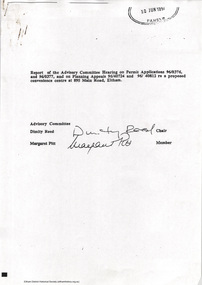
Document - Report, Paul Jerome, Advisory Committee on a Proposed Convenience Centre and an Alternative Shire Proposal - Eltham Gateway Community Precinct Concept Plan - 895 Main Road Eltham, October 1997
On 15 December 1994 the former Shire of Eltham ceased to exist following the Liberal Kennett Government local council amalgamations. A new Nillumbik Shire Council was established with unelected commissioners appointed. That Council sold the former Eltham Shire Council Offices and land at 89S Main Road Eltham to Dallas Price Homes Pty. Ltd. the sale being conditional upon the granting of a planning permit for a petrol station/convenience store, fast food and video outlet. The sale was conditional that if the permit was not granted by 30 August. 1997, the contract could be avoided by either the purchaser or the vendor. The proposed development consisted of a petrol station with undercover fuelling facilities, convenience shopping, a drive through service facility for fast food, an 80 seat cafe, automated banking, a children's play area and retail space. In addition, the proposal included a 200 square metre community facility for Council use, provision of on site carparking over 2 levels for 83 vehicles, and advertising signage. An Advisory Committee consisting of Dimitry Reed and Margaret Pitt was appointed under Section 151 of the Planning and Environment Act 1987 to hear submissions on the proposal to develop the land at 895 Main Road Eltham, the site of the former Eltham Shire Offices. In September 1996, two applications were made by Contour Consultants Australia Pty Ltd on behalf of Dallas Price Homes Ply Ltd, to Nillumbik Shire Council. After extensive notification, the Council received 213 objections and a petition of over 1400 signatures. On October 9, 1996, Nillumbik Shire Council issued Notices of Decision to Grant Permit on Applications number 96/03376 and 96/0377 for the use and development of the land as a convenience Centre consisting of a petrol station, convenience store, cafe/takeaway food premises, a retail facility and a community facility, with associated advertising signs. Objectors to the proposals lodged Planning Appeals number 96/40724 and 96/40812 with the Administrative Appeals Tribunal on November 1, 1996. The grounds of appeal can be summarised as: inappropriate development, insufficient carparking, traffic and access issues, unsatisfactory design, inadequate permit conditions, the proposal being out of character with the area. and being contrary to the purpose and orderly development of the Eltham Town Centre, excessive noise, lack of consultation and unsuitable signage. On November 13, 1996, the Minister for Planning and Local Government directed the Registrar of the Administrative Appeals Tribunal. under Section 41 (1) (a) of the Planning Act 1980, to refer the Appeals to the Governor in Council for determination without a hearing or recommendation by the Tribunal. The Minister for Planning and Local Government called in the Appeals as he considered that they raised major issues of policy relating to the facilitation of development in accordance with the objectives set out in Section 4 of the Planning and Environment Act 1987, and that determination of the Appeals could have a substantial effect on the achievement of these planning objectives. The Minister required the Advisory Committee to consider the planning merits of the proposed use and development, and to address the issues raised in the objections. The Advisory Committee was required to produce a report providing: • The Committee's response to the matters detailed; • Relevant supporting information for the Advisory Committee's recommendation; and • A description of the proceedings conducted by the Advisory Committee and a list of those consulted or heard by the Committee. In March 1997, elections were held in the Shire of Nillumbik and the view of the new Council to this proposal differed from the view held by the earlier Council Hence the Submission made to the Committee by the Shire was against the decision by the Shire of Nillumbik to issue the Notices of Decision to Grant a Permit. The Recommendations of the Advisory Committee were: i. The cafe and take away food premises are as of right uses and are therefore allowable, but that shop and petrol station are unacceptable uses. A community facility is a discretionary use and is acceptable. ii. A development of the type and scale proposed is totally inappropriate for this land and that the Applications number 96/03376 and 96/0377 for the use and development of the land as a convenience Centre consisting of a petrol station, convenience store, café/takeaway food premises, a retail facility and a community facility, with associated advertising signs, be refused. iii. The land should be rezoned for public purposes and should remain in the community's ownership for community use. Following this, the Minister for Planning and Local Government, the Hon. Robert Maclellan, appointed Mr. Paul Jerome as an Advisory Committee under section 151 of the Planning and Environment Act 1987 to consider a Convenience Centre and an alternative proposal by Iha Shire of Nillumbik being the Eltham Gateway Community Precinct Concept Plan for the site of the former Shire of Eltham municipal offices at 895 Main Road, Eltham. In summary, the terms of reference for the Advisory Committee required it to: • consider the merits of the Council proposal • examine the merits of both proposals in terms of net community benefit • address the report of the previous Advisory Committee on the Convenience Centre proposal The Advisory Committee inspected the site and considered all the material before It including submissions made by all parties to the previous Advisory Committee and correspondence received by the Department of Infrastructure both before and after that Committee submltted its report. The Advisory Committee also held discussions with the following people: • Cr. Robert Marshall • Cr. Margaret Jennings • Cr. Lex de Man • Mr. Dallas Howgate of Dallas Price Properties, also Dallas Price Homes • Mr. Barry Rochford, CEO, Shire of Nillumbik • Ms. Yvonne Rust, Planning Officer, Shire of Nillumbik • Mr. Gregory Burgess, Architect of the Eltham Library and of Council’s Community Precinct Concept Plan • Mr. Jim Connor representing Mrs Thelma Barkway of the Eltham Senior Citizens Club Having considered all the material before it, the Committee arrived at two basic conclusions. First, the DPP proposal should be rejected because, on its merits, It does not sufficiently satisfy the requirements of the planning scheme which is a statutory document. The planning scheme requires that, before making a decision on the permit applications for the DPP proposal, a range of matters must be considered. It follows that consideration of these matters should Influence the decision. These matters include local policies relating to character and amenity. In particular, these policies seek • to conserve and enhance the bushland/country atmosphere, artistic heritage and strong sense of community of the Eltham Town Centre by ensuring that the design and height of any new development is sympathetic to existing buildings • to achieve a pleasing physical environment within the Eltham Town Centre by encouraging a high standard of architecture and urban design • to encourage Improvement to pedestrian amenity through such facilities as open and shattered rest areas and meeting places, crossing facilities, pedestrian arcades, pedestrian links to car parks and pedestrian weather protection • to reduce conflict between vehicular traffic and pedestrian flows, and • to encourage pedestrian thoroughfares It is submitted, as set out In the main body of this report, that the DPP proposal fails substantially to meet these policies and In so doing does not merit the exercise of discretion In Its favour with the Issuing of a permit. This finding is not offset by the investment and employment attributes of the proposal. They do not override the need to comply with the planning scheme. Second, the Council proposal, on Its own merits, substantially meets all statutory requirements applicable to this site with a possible reservation about car parking and traffic management which need further definition and assessment as the concept is refined. The Council proposal, however, has a serious weakness in that Its financial viability has not been adequately tested. The Committee refers to 'financial' rather than 'commercial' viability in recognition that Council owns the land and may enter into a range of agreements and partnerships to realise its concept some of which may be truly commercial and some of which may involve an element of subsidy arising from Council's involvement as a public body acting on behalf of its community. The Committee concludes that Council should be given the opportunity, within a reasonable timeframe to establish the financial feasibility of its concept and should develop a strategy for the future of Its land asset at 895 Main Road in the event that Its concept for the site cannot be realised. 895 main road, advisory committee, dallas price homes, eltham, eltham shire office, nillumbik shire council, planning application, administrative appeals tribunal -
 Eltham District Historical Society Inc
Photograph - Digital Photograph, Alan King, Eltham Court House, 730 Main Road, Eltham, 28 December 2007
The Eltham Court House is Eltham's oldest public building. It was classified by the National Trust in 1977. In 1857 five Eltham residents petitioned the licensing magistrates of the Heidelberg district asking for better police protection, including from itinerant gold prospectors who turned to crime when their quest was unsuccessful. In response the Eltham Courthouse was constructed in 1860. Over the years it has also been used for other activities, including for electoral polling purposes, inquests, early meetings of the Eltham Roads Board and even as an overflow classroom. This type of localised solution is characteristic of the self-reliance preserved in Eltham today. The court house is an important symbol of the spirit which makes Eltham distinctive as a community. The Eltham Courthouse is historically significant because its construction was intended to emphasise the centralised control over law and order in the Colony of Victoria in the wake of the 1852 Snodgrass committee report on the Victorian police force and the resulting Police Regulation Act (1853). The nature of the Court House planning and use of architectural devices make the building's function easily interpreted. The arrangement of rooms, with public entry and clerical rooms to the rear, and the use of raised floor levels throughout these spaces to signify relative rank is easily perceived. The distinction in entries, public, magistrate and person-in-custody, and the existing court furniture enhances appreciation of this building. The Eltham Court House is one of only two intact examples in the state of this simple design with projecting entry. The building is of architectural significance because it retains intact early features. These include use of handmade bricks, simple decoration, roof trusses, timber ceiling boards, original windows, doors and associated hardware and a collection of court furniture. Additions to the court house have been done in a manner which did not interfere with the fabric of the original building. Typical cases heard before the Court of Petty Sessions included financial debt, straying livestock, theft, assault, drunkenness, public disorder, truancy, motor vehicle offences, unregistered animals and failing to have children attend school, or be vaccinated. The courthouse operated for over 120 years before it closed in 1985. In April 2021, Nillumbik Shire Council authorised restoration of the building and furnishings. The extensive works required for the total restoration of this highly valued heritage building was undertaken by Ducon Building Solutions and other specialist contractors. Covered under Heritage Overlay, Nillumbik Planning Scheme. Victorian Heritage National Trust of Australia (Victoria) State significance Published: Nillumbik Now and Then / Marguerite Marshall 2008; photographs Alan King with Marguerite Marshall.; p65 A demand for better police protection resulted in the building of the Eltham Courthouse and the police residence beside it. In 1857 five Eltham residents petitioned the Heidelberg district licensing magistrates. They pointed out that Eltham had two hotels, a population of about 1000, and many strangers employed on the public roads. Yet the nearest police were at Heidelberg eight miles (12.8km) away, or at the Caledonia Diggings 21 miles (33.7km) away.1 Subsequently the courthouse and then the police residence, near the corner of Main Road and Brougham Street, were built in 1859/60. The courthouse is Eltham’s oldest public building and the National Trust classified it in 1977. It ceased operation in 1984 and has since been used by local groups. There are only six other known examples of similar small brick country courthouses in Victoria . For £536, a Mr Duncan built the courthouse – a neat, narrow, oblong building with handmade orange bricks. Its gabled roof and porch are covered with brown slate tiles and it has 12-paned windows. Inside, the roof is peaked and the courthouse is still ventilated by oblong slits near the ceiling. Most of the fine carved timber and upholstered furniture is original. The original prisoners’ door, now permanently closed, led from the police station to the dock. Builders, Langridge Wright and Witney built a timber police station (since demolished) and a brick residence to its north,2 for £1150/7/-. Built around the same time were the lock-up behind the residence, also later demolished, and the two-storey orange brick stables. The former police residence also has a brown slate roof and handmade bricks. The front veranda roof is made of corrugated iron, as is the roof of the back weatherboard extension. The application for police protection was approved within a few months and police operated from a cottage rented at ten shillings a week and owned by William Jarrold. This was probably the one at the corner of Main Road and Dalton Street called Jarrold or White Cloud Cottage. In 1858 a second constable was appointed to Eltham following a fight at the hotel. The timber police office a replica of which was built in the early 1990s is at the building’s side. The lock-up was demolished following the relocation of the police to a new station in about 1952. The residence has been used as the Eltham District Historical Society centre since 1997. Records show court cases were held at Eltham before the courthouse was built, but the location is unknown. Some court cases were not very different from those today. In 1891 a man was charged with being drunk while in charge of a horse and was fined ten shillings. The courthouse was used for other purposes during its long history. It was probably used as a polling place as indicated by old photographs of election-day crowds outside. The Eltham Road Board met there from the early 1860s until 1868 when the Board transferred to Kangaroo Ground. During the same period the Road Board Secretary used the courthouse as an office until 1867 when it was transferred to his home at Wingrove Cottage. The courthouse was also used as an overflow classroom for the Dalton Street school in 1875. The two buildings can further link us with Eltham’s early days through Police Department correspondence. The first constable-in-charge was George Reid. In 1860 a letter to The Argus newspaper signed ‘A Sufferer’ declared the Eltham police were not active enough in their duties. The writer suggested that the ‘very snug’ police quarters were too comfortable, and he detailed various incidents including one of an alleged break-in to the Road Board Secretary’s home. But the Board Secretary, C S Wingrove, wrote to the Police Department refuting The Argus letter saying he had received full co-operation from Sen. Constable Peter Lawler.This collection of almost 130 photos about places and people within the Shire of Nillumbik, an urban and rural municipality in Melbourne's north, contributes to an understanding of the history of the Shire. Published in 2008 immediately prior to the Black Saturday bushfires of February 7, 2009, it documents sites that were impacted, and in some cases destroyed by the fires. It includes photographs taken especially for the publication, creating a unique time capsule representing the Shire in the early 21st century. It remains the most recent comprehenesive publication devoted to the Shire's history connecting local residents to the past. nillumbik now and then (marshall-king) collection, eltham, eltham court house, main road -
 Old Gippstown
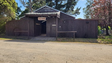
Building - Coach House
Built in the 1920s on Tom Fowler's farm at Willow Grove. Used as a shed.A large square-shaped shed with walls of split timber. It has a gabled roof of corrugated iron, while the floor is made up of wooden cobbles. The roofs of the side extensions are made of wood. The floor is Red Gum blocksagriculture, old gippstown, west gippsland, gippsland, gippsland heritage park, goldfields, coal mine, victorian era, moe, historical village, baw baw shire, willow grove, latrobe valley, old gippstown heritage park, horse drawn vehicles, butchers cart, baker's cart, tanjil valley, latrobe city council -
 Old Gippstown
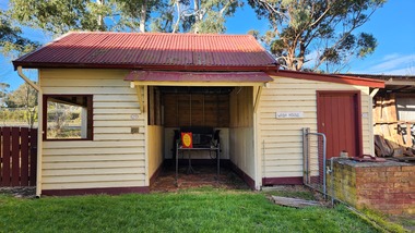
Building - Stable, 1970s
... vehicles Latrobe City Council A small square-shaped timber stable ...Designed and constructed by Old Gippstown from materials at hand.A small square-shaped timber stable building with a gabled corrugated iron roof.old gippstown, west gippsland, gippsland, gippsland heritage park, goldfields, coal mine, victorian era, moe, historical village, stable, old gippstown heritage park, latrobe valley, horse drawn vehicles, latrobe city council -
 Darebin Parklands Association
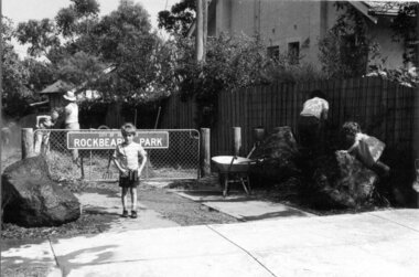
Entrance to Rockbeare Park 15th February 1976, Rockbeare Park Conservation Group, 1976
Ellis Stones, well known landscape designer, designed and supervised the entrance to the Parklands from Rockbeare Grove. He designed a winding path but Council insisted on two straight paths for vehicle access.B&W photograph. Annotated with:[RPCG working bee]. Shows children Phil and Gill Course. This item and all other Darebin Parklands Association archival material is now held by State Library Victoria (Accession No: YMS 13746). Please contact State Library Victoria if access is required. -
 Eltham District Historical Society Inc
Photograph - Digital Photograph, Marguerite Marshall, Jesse Tree playing the Didgeridoo and Swiss Hang Drum at St Andrews Market, 29 March 2008
Published: Nillumbik Now and Then / Marguerite Marshall 2008; photographs Alan King with Marguerite Marshall.; p175 It’s Saturday morning and thousands of people are visiting St Andrews Market at the corner of Heidelberg-Kinglake Road and Proctor Street. It’s hard to find a park. Cars are banked up along the narrow road and crammed in a nearby parking area. Yet, at the market, people look relaxed and happy amongst the yellow box gums on the site where the Wurundjeri people used to gather. Stone artefacts unearthed there by Koorie researcher, Isabel Ellender, indicate the site was once a Wurundjeri meeting place, according to Aboriginal Affairs Victoria. Acoustic sounds mingle with quiet conversations. A guitarist blows a mouth organ while his bare toes tickle chimes. A tiny busker, perhaps five years old, plays a violin while sounds of a harp emerge from the hall. One stallholder, selling delicious-looking pastries, chats to another in Spanish, then to me in broad Australian. ‘I was born in Fitzroy but my mother came from Mexico and my dad from Serbia,’ she smiles. A New Zealander fell in love with Mongolia and now imports their hand-made embroidered clothes and Yurts (tents) and runs adventure tours. A young woman visited Morocco and when friends admired the shoes she bought, she decided to import them and sell them at the market. Oxfam sells Fair Trade toys and clothes and displays a petition to Make Poverty History. Other stalls sell Himalayan salt, jewellery made from seeds from northern Australia, glass paper-weights from China as well as locally grown vegetables, flowers and organic freshly baked bread. A woman sits in a state of bliss under the hands of a masseur. Another offers Reiki or spiritual healing. A juggler tosses devil sticks – ‘not really about the devil,’ he smiles. This skill was practised thousands of years ago in Egypt and South America he says. At the Chai Tent people lounge on cushions in leisurely conversation. The idea for the market was first mooted among friends over a meal at the home of famous jazz and gospel singer Judy Jacques.2 Jacques remembers a discussion with several local artists including Marlene Pugh, Eric Beach, Les Kossatz, Ray Newell and Peter Wallace. ‘We decided we wanted a meeting place, where all the different factions of locals could meet on common ground, sell their goodies and get to know one another,’ Jacques recalls. They chose the site opposite another meeting place, St Andrews Pub. A week later Jacques rode her horse around the district and encouraged her neighbours to come along to the site to buy or sell. On February 23, 1973, about 20 stallholders arrived with tables. They traded ‘second-hand clothes, vegetables, meat, cheese, eggs, chickens, goats, scones, tea, garden pots and peacock feathers’. Now around 2000 people visit each Saturday. People usually linger until dusk. The market – with around 150 stalls of wares from a wide variety of cultures – stands alongside Montsalvat as the most popular tourist attraction in Nillumbik. By the 1990s St Andrews Market was in danger of being loved to death, as the site was becoming seriously degraded. The market was spreading in all directions and the degradation with it. A local council arborist’s report in 1994 noted exposed tree roots from erosion and compaction. The Department of Sustainability and Environment threatened to close the market if the degradation was not rectified. After many months of research, discussions and lobbying by a few residents, the council formed a Committee of Management, with an Advisory Committee, and introduced an Environment Levy. The State Government, the council and the market, funded terracing of the site to stop erosion, and retain moisture and nutrients. Vehicles were excluded from some sensitive areas and other crucial zones reserved for re-vegetation. Volunteers planted more than 3000 locally grown indigenous species. The old Yellow Box trees fully recovered and are expected to give shade for many years to come.This collection of almost 130 photos about places and people within the Shire of Nillumbik, an urban and rural municipality in Melbourne's north, contributes to an understanding of the history of the Shire. Published in 2008 immediately prior to the Black Saturday bushfires of February 7, 2009, it documents sites that were impacted, and in some cases destroyed by the fires. It includes photographs taken especially for the publication, creating a unique time capsule representing the Shire in the early 21st century. It remains the most recent comprehenesive publication devoted to the Shire's history connecting local residents to the past. nillumbik now and then (marshall-king) collection, didgeridoo, jesse tree, st andrews market, swiss hang drum -
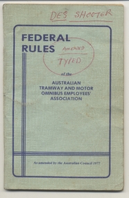 Melbourne Tram Museum
Book, Australian Tramway & Motor Omnibus Employees Association (ATMOEA), "Federal Rules of the Australian Tramway and Motor Omnibus Employees' Association", 1977
Sky blue (faded) coloured book, embossed covers, 64 pages + covers, centre stapled titled "Federal Rules of the Australian Tramway and Motor Omnibus Employees' Association" as amended by the Australian Council 1977. Further typed amendments have been pasted into the book and ink notes to other rule changes that were made. Provides an index of the rules of the Association. Has numerous advertisements for services to members such as accommodation, hotels, motor vehicles. 2nd copy added 24/12/2014.On front cover in red ink has the name "Des Shooter" and "Amended Typed".trams, tramways, atmoea, unions -
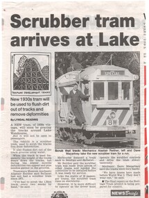 Ballarat Tramway Museum
Newspaper, The Courier Ballarat, "Scrubber tram arrives at Lake", 2/10/1999 12:00:00 AM
Newspaper Clipping from The Courier, Ballarat 2/10/1999 about the arrival of ex MMTB Scrubber tram No. 8 (8W) and the use of the vehicle. Quotes Alastair Reither (who claims he was mis-quoted about the cleaning of the tracks) and Dave Macartney. Has a photo of the tram with Alastair and Dave (btm1218i1.jpg) and a cartoon by Inkcinct (btm1218i2.jpg). Also notes a report on the Heritage Tram Project being prepared for Council. Item written by Lyndal Reading.On rear of sheet in pencil "Courier 2/10/1999 p7"trams, tramways, scrubber tram, btm -
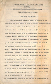 Melbourne Tram Museum
Document - Radio Transcript, Melbourne & Metropolitan Tramways Board (MMTB), "Wireless address 3LO by Mr Alex Cameron, Chairman MMTB 12 Jan 1930 - 745pm - Our Trams and Safety", 12/01/1930 12:00:00 AM
Radio transcript - 10 foolscap sheets, typed, titled "Wireless address 3LO by Mr Alex Cameron, Chairman MMTB 12 Jan 1930 - 745pm - Our Trams and Safety". Introduction refers to a request from the Safety Council of Australia, about safety around trams. Notes braking systems, tramcar maintenance, Preston Workshops, training, medical examinations, accident statistics, cable trams, more accidents with cable cars, knock downs mainly in the city, step accidents, crowding on trams, passengers knocked down by motor cars, tram stops, safety zones, traffic regulation, motor traffic, motor vehicle licencing, parking, and lane markings. Has a lists of don't for motorists, pedestrians and passengers.trams, tramways, radio stations, accidents, behaviour, driver training, brakes, safety, medical, cable trams, statistics, motor vehicles, traffic control -
 Flagstaff Hill Maritime Museum and Village
Vehicle - Tip Dray, Prior to 1930s
... drawn vehicle Springvale Council Jack Bourke Muck Cart Scotch ...A Dray is a type of dead axle wagon that was used to transport heavy loads or objects. They had a flat level floor and while some had no sides, others had box bodies and sides. Tip Drays (also known as Tip Carts, Muck Cart, Scotch Cart, Tumbrel or Putt in different parts of England) were smaller than other drays as their loads were heavy and usually only pulled by one horse. Their basic design included two wheels, a tipping body and shafts. The Tip Dray has a unique mechanism that allows the top to tip backwards to tip the load out of the back of the dray. The tipper was activated by a handle at the front allowing the driver to operate it while still having control over the horse. A Tip Dray was an indispensable piece of equipment in the days before tractors and mechanical trucks. They were used by farmers and carters to transport hay, rocks, bricks, gravel and rubbish etc. and because they were useful for dumping loads, they were favoured for use in road and railway construction. A photo in the collection of the Lorne Historical Society shows a tipping dray being used during the construction of the Great Ocean Road. They were part of the daily street traffic in towns and cities around Australia from the early days of settlement. In Australia in the early 1900's, carters began to join unions to protect their jobs and pay. N.S.W. had a "Trolley, Draymen and Carters Union", Queensland had a "Tip Dray Men's Association" and in W. A. the "Top Dray Driver's Union" had a "cessation of work" in 1911 when they were fighting for an increase in their day's wages. In 1910 a meeting of Tip Carters was held in Geelong at the Trades Hall to discuss the formation of a union (The Geelong Tip Dray Carters) which was a success and a schedule of rates for all carting, whether by contract or day labor, was fixed. By 1912 they had "labelled" more than 50 drays and had representatives on the "Trades Hall and Eight Hours Committee". By the mid 1930's and early 1940's, tip drays were being superseded by mechanical trucks and utes. However tip drays continued to be used in some circumstances. They were a practical solution to the problem of petrol rationing during W. W. 2. It was noted in a letter to the editor in the "Sunshine Advocate" in 1938 that a positive argument for continued use of Tip Drays for rubbish collection related to the idea that a horse drawn vehicle involved with lots of stops and starts at different houses (very like a milkman's delivery route) often involved the horse "driving itself" while the driver picked up the rubbish - something a motor truck was unable to do! Another article written in August 1935 and published in the Age in a parliamentary report into the rubber industry noted "tip drays had almost disappeared and in their place, metal was carted in 5 ton motor trucks" but the report went on to say that as a part of the Government relief work (during the Great Depression) the Government had "to some extent reintroduced the tip drays so that a greater number of men would be employed". This particular tip dray was owned by Mr. Oswald (Jack) Bourke. He used it to deliver dry goods from Sunbury to the Queen Victoria Market in Melbourne several times a week in the 1930's and then (between 1945 and 1962) Mr. Bourke used it on the garbage round in Springvale Victoria for the Springvale Council. The Council owned three drays and the "No. 3" painted on this dray is in recognition of its original number. After the death of Mr. Bourke in 1990, one of Mr. Bourke's sons (Andy) found the dray in a shed and restored it. The sign writing on the back and side panels were added during the restoration. This Tipping Dray is a significant example of a horse drawn vehicle that was used by workers from the early days of white settlement through to the 1940's and even into the early 1960's. It was used in a range of "working class" occupations - road construction, railway construction, carting goods, rubbish collection etc. and would have been found in cities, country towns and on farms.A wooden and metal tipping dray with a box body and four sides. It has two iron and wooden wheels (with 14 spokes), two wooden shafts and a metal tipping mechanism. The back panel folds down to allow loads to be dumped out. It is painted in green and cream with sign writing on one of the sides and on the front and back panels. It features decorative painted lines and designs in burgundy, cream and light blue on most of the wooden parts. The tipping mechanism is on the front of the dray's left side and consists of a metal pin secured with a metal ring, and a lever.Front of dray - "No. 3" Side of dray - "A. & M. BOURKE / Contractors / LONGWARRY" Back of dray - "G.T. ANDREWS / QUEEN VICTORIA MARKET - Stand C23 / Phone DANDENONG 225"flagstaff hill maritime museum and village, warrnambool, shipwreck coast, tipping dray, dray, tip dray, tip cart, vehicles, horse drawn vehicle, springvale council, jack bourke, muck cart, scotch cart, tumbrel, putt, box body, oswald bourke, sunbury, queen victoria market, melbourne, no. 3 -
 Flagstaff Hill Maritime Museum and Village
Photograph - Vessel S. S. Casino in Lady Bay Warrnambool, 1920's - 1930's
This photograph was one of ten photographs donated to Flagstaff Hill Maritime Museum and Village by Fred Trewartha. Frederick John Fox Trewartha (Fred) was a well-known Warrnambool businessman. He was born in Beeac near Geelong in 1920 and came to Warrnambool with his family as a very young child. He was apprenticed to his father John, as a saddler and later opened his own shop on Raglan Parade. He then moved into working with tarpaulins and canvases for the trucking industry. Fred was keenly interested in photography (and was a member of the Warrnambool Cine Club), yachting and boat building. He kept his yacht moored at Port Fairy for many years and participated in sailing events locally and interstate. He also built boats with his sons. He had the opportunity to meet many older sailors and it's thought this photo (and others in the set) may have been given to him by one of these men. Fred Trewartha died in 2016 in Warrnambool. Warrnambool by the 1920's and 1930's had become a popular holiday destination with visitors arriving by steamer and train. It was during these decades that a "Surf Bathers Association" began in Warrnambool in response to the growing popularity of local sea bathing. They worked with the local council to develop a "Beach Improvement Fund" and a comprehensive plan of "Beach Improvement" which included erecting and maintaining beach boxes, building a kiosk, improving paths and roads to the beach, planting marram grass on the sand dunes, building new enclosures for vehicles and horses and generally making the beach more attractive for visitors and townspeople. The 1930's was also an era when free "Herald" Learn-to-Swim classes were being held throughout Victoria. In 1931 it was reported in "The Age" newspaper that "over the past week in Warrnambool, 250 pupils had passed through the hands of the local life saving club swimming instructors". The Port of Warrnambool - In the early years the Port of Warrnambool was a busy port. Steamships and sailing ships were frequent visitors to the port. Steam navigation companies were plentiful, carrying passengers and freighting cargo such as coal, timber, food, livestock, furniture, hardware and haberdashery between Melbourne and the ports along the southwest coast of Victoria, including Warrnambool. The carts would take their loads into the township for distribution. The Breakwater was built (using 32 ton blocks of concrete) between 1874 and 1890 to provide ships with greater protection from the Southern Ocean. The Lifeboat and Rocket House - The coastline of South West Victoria has had over 600 shipwrecks and many lost lives; even in Warrnambool’s Lady Bay there were around 16 known shipwrecks between 1850 and 1905, with eight lives lost. In 1859 the first Government-built lifeboat arrived at Warrnambool Harbour and a shed was soon built to house it, followed in 1864 by a rocket house to safely store the Rocket Rescue equipment. In 1878 the buildings were moved to the Breakwater area, and in 1910 the new Lifeboat Warrnambool arrived with its ‘self-righting’ design. For almost one hundred years the lifeboat and rocket crews, mostly local volunteers, trained regularly to maintain and improve their skills, summoned when needed by alarms, gunshots, ringing bells and foghorns. Some became local heroes but all served an important role. By the end of the 1950s the lifeboat and rescue equipment had become obsolete. The S.S. Casino was a passenger and freight steamer built in Dundee, Scotland, in 1882 for the Newcastle and Hunter River Steam Navigation Company of N.S.W. She weighed 425 tons gross with a length of 160.4 feet, beam of 24.1 feet and a depth of 10.2 feet. She had saloon accommodation for 35 people, a fore cabin for 25 more people, and she carried 300 tons of cargo. While on her delivery journey on May 30th 1882, the S.S. Casino called in at the Port of Warrnambool for coal, narrowly escaping going ashore in gale force winds due to the quick action of the pilot. At that time, still at anchor, she impressed the directors of the Belfast and Koroit Steam Navigation Company so much that they bought her immediately; she was ideal for trade along the West Coast of Victoria. (The Belfast and Koroit Steam Navigation Company was first managed by Messers. Saltau and Osburne and after the passing of Mr. Osburne, by produce merchants Messers H. Sautau and Sons, who had a hay and corn store and shipping agency on the corner of Liebig and Koroit Streets in Warrnambool. ) The S.S. Casino became “the most famous steamer to operate in Victorian waters along the West Coast” by author Jack Loney. Captain Boyd was her first Master, followed by Captain Chapman, who stayed with her from 1890 until 1924. Captain W. Robertson followed for a short term, and then Captain Middleton then took command from 1925 - 1932. An article published on Monday 11th June 1932 in The Sun News Pictorial (Melbourne) giving a detailed history of S. S. Casino said "owned by Port Fairy interests, she was an integral part of the town's development ... for a long time, her arrival in Port Fairy was an event, the townspeople going down to the wharf to see her come in". It also said "Except when the weather was bad, the Casino hugged the coast on her trips and passengers obtained wonderful views of the sandstone terraces and caves. A little time ago every member of her regular crew except one, was a Scotsman." The S.S. Casino had several mishaps during her life. One was on 3rd January 1898 when she collided with the S.S. Flinders in Apollo Bay with minor damage. Another was on 24th October 1924 when she grounded on a reef at Point Hawdon near Grey River and most of her cargo (of Christmas goods) had to be dumped into the sea. Then in February 1929 she was ‘holed’ when she struck a submerged object as she entered Lady Bay, Warrnambool. In the years following the turn of the century, the S.S. Casino remained the only regular trader with normal passenger accommodation along the West Coast. From 1882 she had made at least 2,500 voyages on the one run. On the morning of 10th July 1932, after attempting to berth at Apollo Bay jetty in heavy seas, Captain Middleton decided to take her out into the bay and wait until the seas abated. It was not realised that the anchor used to steady her as she manoeuvred to her berth had pierced her hull. She put about and headed for the beach but sank. Captain Middleton and nine others lost their lives; nine people were rescued including the two female passengers. Captain Middleton had been in charge of the S.S. Casino for seven years. He was the first ship’s Master to lose his life in a shipwreck in the West Coast trade. In June 1932, the directors of the Belfast and Koroit Steam Navigation Company had proposed to celebrate the completion of fifty years of trading by the steamer Casino in August, but tragically the Casino was wrecked only one month later (and "was only one month off completing its fifty years of valuable service between Melbourne and Portland.") Flagstaff Hill’s collection has a photograph of a portrait of Captain Chapman, a ship model of the S.S. Casino that shows both forms of power under which she sailed, steam and sail. The ship is painted green and flies three flags. The inscription across the case of the ship model, incorrectly dated, tells the sad story of the wreck of the ship and the loss of lives on July 10th 1932 at Apollo Bay. A print in the Collection shows S.S. Casino underway in the heavy sea off Point Lonsdale, another two photographs show her at the Port of Warrnambool, leaving from the Breakwater in Lady Bay and another identifies the S.S. Casino as a ship from the Belfast and Koroit Steam Navigation Company. (Belfast is the original name for the township of Port Fairy).This photograph is significant because of its association with the coastal trader S.S. Casino and its significance to trade along Victoria's West Coast in the late 19th and early 20th centuries. The wreck of the S.S. Casino is considered an important part of Victorian and Australian cultural heritage and as such has been declared and protected as an Historic Shipwreck under State and Commonwealth Law in the Commonwealth Historic Shipwrecks Act (1976). It is also significant as it shows the early years of tourism in Warrnambool and the important role the beach played in the lives of residents and visitors.A black and white photograph (with colour tinting) showing Lady Bay in Warrnambool with the Breakwater in the background. The S. S. Casino is moored at the Breakwater and the lifeboat shed and a coal train can be seen on the Breakwater. Six swimmers are standing in the water. On the back of the photograph are the donor's name and telephone number (written in black biro) and the name of the S. S. Casino and its tonnage written in blue ink. A blurred number has been stamped on plus a "M' written in pencil.Donor's name, address and phone number / "S. S. Casino" / "500 TONS" / "REG" "- - - 09 " (blurred numbers) / "M"warrnambool, great ocean road, shipwreck coast, lady bay, breakwater, fred trewartha, frederick john fox trewartha, surf bathers association, sea bathing, swimming, warrnambool beach, beach improvement fund, port of warrnambool, steamships, lifeboat house, rocket house, lifeboat crew, s. s. casino, belfast and koroit steam navigation company, saltau and osburne, captain middleton, apollo bay, apollo bay shipwreck -
 Ballarat Tramway Museum
Legal record, City of Ballaarat, City of Ballaarat - by-law - No. 120, June 1939
By-Law No. 120, details the regulation or control of traffic, motor vehicles and horse drawn, pedestrians in the City of Ballaarat, including tram stops and safety zones. Dated 19/6/1939. Signed Alex M King Mayor, J Pryor Councillor and Geo F Morton Town Clerk.Yields information about the operation of vehicles in Sturt St. Ballarat at the time when Councils were responsible for traffic control within their municipalities.Folded sheet - 8 pages printed centre stapled. Two copies, includes one marked reprint.tramways, city of ballaarat, sturt st, two way traffic, traffic control