Showing 378 items matching "cut work"
-
 Eltham District Historical Society Inc
Photograph - Aerial Photograph, Landata, Eltham; Crown Allotment 15, Section 5, Parish of Nillumbik (Stokes Orchard Estate), Jan. 1984
Centred on present day Diosma Rd, Stokes Pl, Nyora Rd and Eucalyptus Rd Historic Aerial Imagery Source: Landata.vic.gov.au Aerial Photo Details: Project No :1716 Project : WESTERN PORT FORESHORES Run : 15 Frame : 70 Date : 01/1984 Film Type : B/W Camera : RC8 Flying Height : 5300 Scale : 10000 Film Number : 3833 GDA2020 : 37°42'38"S, 145°10'09"E MGA2020 : 338612, 5824719 (55) Melways : 22 D4 (ed. 42) A History of the Development of Crown Allotment 15, Section 5, Parish of Nillumbik – Stokes Orchard Crown Allotment 15, Section 5, Parish of Nillumbik (CA15) is a square allotment of 158 acres or approximately a quarter of a square mile. It lies just beyond the eastern end of Pitt Street, south of Nyora Road to the northern end of Eucalyptus Road and extends east from Eucalyptus Road to Reynolds Road. The topography of CA15 is generally steep, sloping up to a hill near the centre of the land, the ridgeline passing through the properties along the southern side of Diosma Road. Eucalyptus Road is a straight north-south road with its northern end at the north west corner of CA15. Until the end of the 1970s this road was an un-named Government Road and was largely not open to traffic. With residential development in the 1970s the road was constructed, and the council allocated the name obviously in recognition of the predominant species of the local bushland. CA15 was purchased from the Crown by George D’Arley Boursiquot, a prominent Melbourne printer, on 28th October 1852. On November 23, 1922, former Member for Gippsland and Melbourne Real Estate Agent, Hubert Patrick Keogh purchased the allotment then sold it March 13, 1925, to local farmer, Robert David Taylor, a former Shire of Eltham Councillor (1911-1920) and Shire President (1919). Taylor had extensive land holdings stretching west towards Bible Street and Main Road. The Taylor home was situated at the top of the hill in Bible Street at present day 82 Bible Street. At the time of Taylor’s purchase in 1925, CA15 was subdivided into 48 lots that could be described as small rural properties or large residential lots. A typical lot size was one hectare or 2.5 acres. The subdivision created two roads, Nyora Road, and Diosma Road, each following an irregular alignment between Eucalyptus and Reynolds Roads. However, the lots were not sold off separately nor were the roads constructed. The land effectively remained as one parcel for many further years. Robert David Taylor died November 30, 1934, and probate was granted to his son of the same name, Robert David Taylor of Bible Street, Salesman and William McLelland Vance Taylor of 73 Emmeline Street, Northcote, Clerk, with the transfer of the land into their names on July 8, 1935. Frank Stokes worked as a qualified accountant at Kennons leather factory in Burnley, while living at 1 Thomas Street, Mitcham. He suffered from migraines and wanted to return to working the land (he had previously worked on farms and orchards since coming to Australia from England in 1926, both in WA and Vic.). He first travelled to the district by train in July 1942 to find land with the intention to establish an orchard. By chance he met Arthur Bird of Bird Orchard (bounded by Pitt Street, Eucalyptus Road, and Wattle Grove) and they got talking over their common interest. Arthur put Frank up for the night and pointed out the land, 158 acres- part of the Taylor Estate- £900, Crown Allotment 15, Section 5, Parish of Nillumbik (CA15) somewhat diagonally opposite Bird Orchard. Stokes applied through the Riverina Agency to purchase the land who in turn applied for permission from Canberra to sell as there was a new government regulation introduced during the Second World War banning land sales except for immediate production. Stokes obtained a loan on his Mitcham house of £600 @ 5% and paid £450 deposit with quarterly payments of £15 spread over 5 years. Stokes was assisted and advised by Arthur Bird who farmed the neighbouring orchard. In early 1943 Stokes took possession and would catch the train out to Eltham on Fridays after work and began building a hut on the corner of Nyora Road and the Government Road (Eucalyptus Road) for shelter and to lock up tools. He established an orchard on the central western part of the land through the centre of which ran a natural waterway (part of the present-day linear park) and was able to pay a neighbour (Hawkins) to help with clearing and fencing 25 acres, and with a horse and single furrowed plough, planted approximately 2,500 fruit trees - cherries, peaches, plums, almonds, pears, apricots and lemons as well as a few apples and oranges; a massive task. Aerial photographs from the 1940s through to the 1990s clearly show the orchard with most of the larger CA15 site remaining as natural bushland. A huge problem was hares and rabbits eating all the new buds off the tiny trees. As well as laying poison he painted the trees with a mixture of cow manure and lime, often working by moonlight. Procurement of wire and wire netting was difficult because of the war but after much effort he obtained a permit from the Agricultural Department for supplies in March 1944. In February 1945 Stokes applied for a permit to build a “packing shed” as no house building was allowed. It was to be 33 feet x 21 feet and cost £312. It was constructed mostly from second-hand materials, which were hard to obtain, especially iron for roofing. Stokes finished work at Kennons on October 31, 1945, and in March 1946 he sold the family home at Mitcham for £1,230 plus £170 for furniture. On May 15, 1946, title to the CA15 property was issued to Frank Howard Alfred Stokes, Orchardist and Gladys Ethel Stokes, Married Woman, both of Pitt Street, Eltham. The family of five then moved into the very unfinished “packing shed” at Eltham, which was a struggle to weatherproof. Eventually rooms were divided off and lined with hessian bags and whitewashed. Their income was firewood (cut and sold), selling rockery stones and cut Sweet Bursaria. (It was discovered during the 1940s that Sweet Bursaria contained the sunscreen compound Aesculin. The RAAF utilised this compound from Sweet Bursaria during WW2 for pilots and gunners.) The orchard’s first fruit sale was a half-case of Le Vanq peaches in December 1947 for the price of 8 shillings. In 1956 plans for house were drawn and Glen Iris bricks purchased (1956 Olympic Rings variant). The building of the house commenced in 1957 - 12 feet of original packing shed was removed – and was completed in 1959. Water was connected from newly built pressure storage on the property at the end of 1959 and the electricity connection for the first time at 3pm on April 29, 1960. The house remains to present day (somewhat modified) at 1 Nyora Road, home to Nyora Studio Gallery. On occasions, spare remnants of the 1956 bricks have been known to be unearthed in gardens on the estate as they were utilised by Frank Stokes to fill in rabbit holes. On May 26, 1950, a parcel of land was compulsorily acquired by the Melbourne and Metropolitan Board of Works on the hilltop to establish an easement for a high-level service reservoir to augment Eltham’s water supply. The project also included pipe tracks for the necessary water mains. The reservoir has now been superseded by higher level water tanks east of Reynolds Road and its former site is now a public reserve. On November 27, 1964, the State Electricity Commission served notice to compulsorily acquire a further parcel through the eastern part of the land for a major electricity transmission line that augmented supply from the La Trobe Valley to Melbourne. The easement was registered February 11, 1966. The easement was widened July 18, 1969 for a second transmission line to be constructed. In 1971 Melbourne Metropolitan Planning Scheme amendments adopted Nyora Road as the boundary between a residential zone to the north and a rural zone to the south. This determined the future development of the land. In the mid-1970s the Shire of Eltham divided the orchard into numerous rate-able parcel lots, the 48 lots having been established in 1925 and the subsequent rates assessment proved unsustainable for Stokes. He commenced selling lots outside the boundary of the orchard, north of Diosma and South of Nyora. However shortly later the land between Nyora and Diosma Roads and west of the electricity easement was sold and subdivided into residential lots, a housing development by Macquarie Builders and marketed as the Stokes Orchard Estate. New streets were created, and most were named after trees, although one, Stokes Place, commemorates the former owners. The development was undertaken in two stages; Stage 1 (1975) encompassing Scarlet Ash Court, Ironbark Close and Peppermint Grove bounded by Nyora and Eucalyptus roads and Stage 2 (1978) encompassing Stokes Place, Orchard Way, The Crest and The Lookout bound by Nyora and Diosma roads. The developer, Macquarie Builders went bankrupt shortly after the release of Stage 2 leaving many purchasers to fend for themselves and arrange for their own independent builders. There were also difficulties with sewerage for the land immediately south of Diosma Road and so the conventional residential lots were abandoned in favour of larger lots. The development of Orchard Way, The Crest and The Lookout did not proceed as planned and the proposed lots were incorporated into five-acre parcels instead. These included a low-density group housing development by the Graves family and the award winning Choong House (1983) with Gordon Ford developed garden immediately next door situated on the ridge of the hill nestled amongst the original bush, Eucalypt trees and Sweet Bursaria. In 1994, Nillumbik Shire Council applied Significant Environment and Significant Landscape overlays upon the properties on the south side of Diosma Road to ensure protection of this natural bush garden environment. With the arrival of the sewer along Diosma Road in the 1990s, most of these five-acre parcels have since been subdivided multiple times. The Choong house presently sits on a 2.7-acre property, which in 2022 Nillumbik Council nominated for Cultural Significance Heritage protection and is considered potentially significant at State level. The Stokes family were also associated with the Eltham Christian Church. In the 1970s this church had met in temporary premises in Eltham. Lots of the original 1925 subdivision remained south of Nyora Road and a number of these lots were utilized for the Eltham Christian School, which was established by the Eltham Christian Church in 1981. The school operated on this site until 2000. The premises are now used by The Vine Baptist Church. By the mid-1980s the whole of CA15 had been developed for residential and school purposes, except for the sections north of Diosma Road and between the transmission lines and Reynolds Road. Sewerage issues had been resolved for the section north of Diosma Road and in 1987 it was in the process of being subdivided into residential lots. The development coincided with the discovery of colonies of the rare and endangered Eltham Copper Butterfly on the site. This resulted in a community and political campaign to save the butterfly habitat. With the co-operation of the land developer the subdivision was altered to create two bushland reserves in the critical butterfly habitat areas. In the late 1980s the State Government was investigating options for establishing a metropolitan ring road link between Diamond Creek and Ringwood. The chosen route was adjacent to Reynolds Road and so this created a freeze on development of CA15 between Reynolds Road and the electricity easement. The ring road proposal was eventually abandoned, and this part of the land was subdivided into low density residential lots. Diosma Road has been discontinued at the electricity easement and the eastern part incorporated into View Mount Court with access from Reynolds Road. The whole of CA15 has now been developed for residential or associated purposes, ranging from conventional density to quite low density south of Nyora Road. Some remnants of the orchard remain, a few cherry trees on the Graves property and a lone apple tree in Stokes Place. The butterfly reserves comprise significant areas of remnant bushland. Linear reserves through the estate link with central Eltham via the Woodridge linear reserve and with Research along the electricity easement. CA15 as it exists today has a complicated history of rural use, Government acquisition, urban development, and community action. References: • “Stokes Orchard, an incomplete history”; Russell Yeoman with Doug Orford • Correspondence, Beryl Bradbury (nee Stokes) • Aerial Photographs, 1931-1991, Landata (landata.vic.gov.au) • Certificate of Title, Vol. 4930 Fol. 985900 • Plan Number LP 10859 aerial photo, diosma road, eltham copper butterfly, eucalyptus road, ironbark close, nyora road, peppermint grove, peter & elizabeth pidgeon collection, power transmission lines, reynolds road, scarlet ash court, stokes orchard estate, stokes place, woodridge estate, frank stokes -
 Eltham District Historical Society Inc
Photograph - Aerial Photograph, Landata, Eltham; Crown Allotment 15, Section 5, Parish of Nillumbik (Stokes Orchard Estate), Mar. 1987
Centred on present day Diosma Rd, Stokes Pl, Nyora Rd and Eucalyptus Rd Historic Aerial Imagery Source: Landata.vic.gov.au Aerial Photo Details: Project No :1716 Project : WESTERN PORT FORESHORES Run : 15 Frame : 108 Date : 03/1987 Film Type : B/W Camera : RC10 Flying Height : 5600 Scale : 10000 Film Number : 4102 GDA2020 : 37°43'00"S, 145°10'13"E MGA2020 : 338725, 5824036 (55) Melways : 22 D5 (ed. 42)719 (55) Melways : 22 D4 (ed. 42) A History of the Development of Crown Allotment 15, Section 5, Parish of Nillumbik – Stokes Orchard Crown Allotment 15, Section 5, Parish of Nillumbik (CA15) is a square allotment of 158 acres or approximately a quarter of a square mile. It lies just beyond the eastern end of Pitt Street, south of Nyora Road to the northern end of Eucalyptus Road and extends east from Eucalyptus Road to Reynolds Road. The topography of CA15 is generally steep, sloping up to a hill near the centre of the land, the ridgeline passing through the properties along the southern side of Diosma Road. Eucalyptus Road is a straight north-south road with its northern end at the north west corner of CA15. Until the end of the 1970s this road was an un-named Government Road and was largely not open to traffic. With residential development in the 1970s the road was constructed, and the council allocated the name obviously in recognition of the predominant species of the local bushland. CA15 was purchased from the Crown by George D’Arley Boursiquot, a prominent Melbourne printer, on 28th October 1852. On November 23, 1922, former Member for Gippsland and Melbourne Real Estate Agent, Hubert Patrick Keogh purchased the allotment then sold it March 13, 1925, to local farmer, Robert David Taylor, a former Shire of Eltham Councillor (1911-1920) and Shire President (1919). Taylor had extensive land holdings stretching west towards Bible Street and Main Road. The Taylor home was situated at the top of the hill in Bible Street at present day 82 Bible Street. At the time of Taylor’s purchase in 1925, CA15 was subdivided into 48 lots that could be described as small rural properties or large residential lots. A typical lot size was one hectare or 2.5 acres. The subdivision created two roads, Nyora Road, and Diosma Road, each following an irregular alignment between Eucalyptus and Reynolds Roads. However, the lots were not sold off separately nor were the roads constructed. The land effectively remained as one parcel for many further years. Robert David Taylor died November 30, 1934, and probate was granted to his son of the same name, Robert David Taylor of Bible Street, Salesman and William McLelland Vance Taylor of 73 Emmeline Street, Northcote, Clerk, with the transfer of the land into their names on July 8, 1935. Frank Stokes worked as a qualified accountant at Kennons leather factory in Burnley, while living at 1 Thomas Street, Mitcham. He suffered from migraines and wanted to return to working the land (he had previously worked on farms and orchards since coming to Australia from England in 1926, both in WA and Vic.). He first travelled to the district by train in July 1942 to find land with the intention to establish an orchard. By chance he met Arthur Bird of Bird Orchard (bounded by Pitt Street, Eucalyptus Road, and Wattle Grove) and they got talking over their common interest. Arthur put Frank up for the night and pointed out the land, 158 acres- part of the Taylor Estate- £900, Crown Allotment 15, Section 5, Parish of Nillumbik (CA15) somewhat diagonally opposite Bird Orchard. Stokes applied through the Riverina Agency to purchase the land who in turn applied for permission from Canberra to sell as there was a new government regulation introduced during the Second World War banning land sales except for immediate production. Stokes obtained a loan on his Mitcham house of £600 @ 5% and paid £450 deposit with quarterly payments of £15 spread over 5 years. Stokes was assisted and advised by Arthur Bird who farmed the neighbouring orchard. In early 1943 Stokes took possession and would catch the train out to Eltham on Fridays after work and began building a hut on the corner of Nyora Road and the Government Road (Eucalyptus Road) for shelter and to lock up tools. He established an orchard on the central western part of the land through the centre of which ran a natural waterway (part of the present-day linear park) and was able to pay a neighbour (Hawkins) to help with clearing and fencing 25 acres, and with a horse and single furrowed plough, planted approximately 2,500 fruit trees - cherries, peaches, plums, almonds, pears, apricots and lemons as well as a few apples and oranges; a massive task. Aerial photographs from the 1940s through to the 1990s clearly show the orchard with most of the larger CA15 site remaining as natural bushland. A huge problem was hares and rabbits eating all the new buds off the tiny trees. As well as laying poison he painted the trees with a mixture of cow manure and lime, often working by moonlight. Procurement of wire and wire netting was difficult because of the war but after much effort he obtained a permit from the Agricultural Department for supplies in March 1944. In February 1945 Stokes applied for a permit to build a “packing shed” as no house building was allowed. It was to be 33 feet x 21 feet and cost £312. It was constructed mostly from second-hand materials, which were hard to obtain, especially iron for roofing. Stokes finished work at Kennons on October 31, 1945, and in March 1946 he sold the family home at Mitcham for £1,230 plus £170 for furniture. On May 15, 1946, title to the CA15 property was issued to Frank Howard Alfred Stokes, Orchardist and Gladys Ethel Stokes, Married Woman, both of Pitt Street, Eltham. The family of five then moved into the very unfinished “packing shed” at Eltham, which was a struggle to weatherproof. Eventually rooms were divided off and lined with hessian bags and whitewashed. Their income was firewood (cut and sold), selling rockery stones and cut Sweet Bursaria. (It was discovered during the 1940s that Sweet Bursaria contained the sunscreen compound Aesculin. The RAAF utilised this compound from Sweet Bursaria during WW2 for pilots and gunners.) The orchard’s first fruit sale was a half-case of Le Vanq peaches in December 1947 for the price of 8 shillings. In 1956 plans for house were drawn and Glen Iris bricks purchased (1956 Olympic Rings variant). The building of the house commenced in 1957 - 12 feet of original packing shed was removed – and was completed in 1959. Water was connected from newly built pressure storage on the property at the end of 1959 and the electricity connection for the first time at 3pm on April 29, 1960. The house remains to present day (somewhat modified) at 1 Nyora Road, home to Nyora Studio Gallery. On occasions, spare remnants of the 1956 bricks have been known to be unearthed in gardens on the estate as they were utilised by Frank Stokes to fill in rabbit holes. On May 26, 1950, a parcel of land was compulsorily acquired by the Melbourne and Metropolitan Board of Works on the hilltop to establish an easement for a high-level service reservoir to augment Eltham’s water supply. The project also included pipe tracks for the necessary water mains. The reservoir has now been superseded by higher level water tanks east of Reynolds Road and its former site is now a public reserve. On November 27, 1964, the State Electricity Commission served notice to compulsorily acquire a further parcel through the eastern part of the land for a major electricity transmission line that augmented supply from the La Trobe Valley to Melbourne. The easement was registered February 11, 1966. The easement was widened July 18, 1969 for a second transmission line to be constructed. In 1971 Melbourne Metropolitan Planning Scheme amendments adopted Nyora Road as the boundary between a residential zone to the north and a rural zone to the south. This determined the future development of the land. In the mid-1970s the Shire of Eltham divided the orchard into numerous rate-able parcel lots, the 48 lots having been established in 1925 and the subsequent rates assessment proved unsustainable for Stokes. He commenced selling lots outside the boundary of the orchard, north of Diosma and South of Nyora. However shortly later the land between Nyora and Diosma Roads and west of the electricity easement was sold and subdivided into residential lots, a housing development by Macquarie Builders and marketed as the Stokes Orchard Estate. New streets were created, and most were named after trees, although one, Stokes Place, commemorates the former owners. The development was undertaken in two stages; Stage 1 (1975) encompassing Scarlet Ash Court, Ironbark Close and Peppermint Grove bounded by Nyora and Eucalyptus roads and Stage 2 (1978) encompassing Stokes Place, Orchard Way, The Crest and The Lookout bound by Nyora and Diosma roads. The developer, Macquarie Builders went bankrupt shortly after the release of Stage 2 leaving many purchasers to fend for themselves and arrange for their own independent builders. There were also difficulties with sewerage for the land immediately south of Diosma Road and so the conventional residential lots were abandoned in favour of larger lots. The development of Orchard Way, The Crest and The Lookout did not proceed as planned and the proposed lots were incorporated into five-acre parcels instead. These included a low-density group housing development by the Graves family and the award winning Choong House (1983) with Gordon Ford developed garden immediately next door situated on the ridge of the hill nestled amongst the original bush, Eucalypt trees and Sweet Bursaria. In 1994, Nillumbik Shire Council applied Significant Environment and Significant Landscape overlays upon the properties on the south side of Diosma Road to ensure protection of this natural bush garden environment. With the arrival of the sewer along Diosma Road in the 1990s, most of these five-acre parcels have since been subdivided multiple times. The Choong house presently sits on a 2.7-acre property, which in 2022 Nillumbik Council nominated for Cultural Significance Heritage protection and is considered potentially significant at State level. The Stokes family were also associated with the Eltham Christian Church. In the 1970s this church had met in temporary premises in Eltham. Lots of the original 1925 subdivision remained south of Nyora Road and a number of these lots were utilized for the Eltham Christian School, which was established by the Eltham Christian Church in 1981. The school operated on this site until 2000. The premises are now used by The Vine Baptist Church. By the mid-1980s the whole of CA15 had been developed for residential and school purposes, except for the sections north of Diosma Road and between the transmission lines and Reynolds Road. Sewerage issues had been resolved for the section north of Diosma Road and in 1987 it was in the process of being subdivided into residential lots. The development coincided with the discovery of colonies of the rare and endangered Eltham Copper Butterfly on the site. This resulted in a community and political campaign to save the butterfly habitat. With the co-operation of the land developer the subdivision was altered to create two bushland reserves in the critical butterfly habitat areas. In the late 1980s the State Government was investigating options for establishing a metropolitan ring road link between Diamond Creek and Ringwood. The chosen route was adjacent to Reynolds Road and so this created a freeze on development of CA15 between Reynolds Road and the electricity easement. The ring road proposal was eventually abandoned, and this part of the land was subdivided into low density residential lots. Diosma Road has been discontinued at the electricity easement and the eastern part incorporated into View Mount Court with access from Reynolds Road. The whole of CA15 has now been developed for residential or associated purposes, ranging from conventional density to quite low density south of Nyora Road. Some remnants of the orchard remain, a few cherry trees on the Graves property and a lone apple tree in Stokes Place. The butterfly reserves comprise significant areas of remnant bushland. Linear reserves through the estate link with central Eltham via the Woodridge linear reserve and with Research along the electricity easement. CA15 as it exists today has a complicated history of rural use, Government acquisition, urban development, and community action. References: • “Stokes Orchard, an incomplete history”; Russell Yeoman with Doug Orford • Correspondence, Beryl Bradbury (nee Stokes) • Aerial Photographs, 1931-1991, Landata (landata.vic.gov.au) • Certificate of Title, Vol. 4930 Fol. 985900 • Plan Number LP 10859 aerial photo, diosma road, eltham copper butterfly, eucalyptus road, ironbark close, nyora road, peppermint grove, peter & elizabeth pidgeon collection, power transmission lines, reynolds road, scarlet ash court, stokes orchard estate, stokes place, woodridge estate, frank stokes -
 Eltham District Historical Society Inc
Photograph - Aerial Photograph, Landata, Eltham; Crown Allotment 15, Section 5, Parish of Nillumbik (Stokes Orchard Estate), Sep. 1991
Centred on present day Diosma Rd, Stokes Pl, Nyora Rd and Eucalyptus Rd Historic Aerial Imagery Source: Landata.vic.gov.au Aerial Photo Details: Project No :2072 Project : MELBOURNE PROJECT Run : 13 Frame : 119 Date : 09/1991 Film Type : COL Camera : RC10 Flying Height : 8300 Scale : 15000 Film Number : 4419 GDA2020 : 37°43'07"S, 145°09'35"E MGA2020 : 337812, 5823811 (55) Melways : 22 B6 (ed. 42) A History of the Development of Crown Allotment 15, Section 5, Parish of Nillumbik – Stokes Orchard Crown Allotment 15, Section 5, Parish of Nillumbik (CA15) is a square allotment of 158 acres or approximately a quarter of a square mile. It lies just beyond the eastern end of Pitt Street, south of Nyora Road to the northern end of Eucalyptus Road and extends east from Eucalyptus Road to Reynolds Road. The topography of CA15 is generally steep, sloping up to a hill near the centre of the land, the ridgeline passing through the properties along the southern side of Diosma Road. Eucalyptus Road is a straight north-south road with its northern end at the north west corner of CA15. Until the end of the 1970s this road was an un-named Government Road and was largely not open to traffic. With residential development in the 1970s the road was constructed, and the council allocated the name obviously in recognition of the predominant species of the local bushland. CA15 was purchased from the Crown by George D’Arley Boursiquot, a prominent Melbourne printer, on 28th October 1852. On November 23, 1922, former Member for Gippsland and Melbourne Real Estate Agent, Hubert Patrick Keogh purchased the allotment then sold it March 13, 1925, to local farmer, Robert David Taylor, a former Shire of Eltham Councillor (1911-1920) and Shire President (1919). Taylor had extensive land holdings stretching west towards Bible Street and Main Road. The Taylor home was situated at the top of the hill in Bible Street at present day 82 Bible Street. At the time of Taylor’s purchase in 1925, CA15 was subdivided into 48 lots that could be described as small rural properties or large residential lots. A typical lot size was one hectare or 2.5 acres. The subdivision created two roads, Nyora Road, and Diosma Road, each following an irregular alignment between Eucalyptus and Reynolds Roads. However, the lots were not sold off separately nor were the roads constructed. The land effectively remained as one parcel for many further years. Robert David Taylor died November 30, 1934, and probate was granted to his son of the same name, Robert David Taylor of Bible Street, Salesman and William McLelland Vance Taylor of 73 Emmeline Street, Northcote, Clerk, with the transfer of the land into their names on July 8, 1935. Frank Stokes worked as a qualified accountant at Kennons leather factory in Burnley, while living at 1 Thomas Street, Mitcham. He suffered from migraines and wanted to return to working the land (he had previously worked on farms and orchards since coming to Australia from England in 1926, both in WA and Vic.). He first travelled to the district by train in July 1942 to find land with the intention to establish an orchard. By chance he met Arthur Bird of Bird Orchard (bounded by Pitt Street, Eucalyptus Road, and Wattle Grove) and they got talking over their common interest. Arthur put Frank up for the night and pointed out the land, 158 acres- part of the Taylor Estate- £900, Crown Allotment 15, Section 5, Parish of Nillumbik (CA15) somewhat diagonally opposite Bird Orchard. Stokes applied through the Riverina Agency to purchase the land who in turn applied for permission from Canberra to sell as there was a new government regulation introduced during the Second World War banning land sales except for immediate production. Stokes obtained a loan on his Mitcham house of £600 @ 5% and paid £450 deposit with quarterly payments of £15 spread over 5 years. Stokes was assisted and advised by Arthur Bird who farmed the neighbouring orchard. In early 1943 Stokes took possession and would catch the train out to Eltham on Fridays after work and began building a hut on the corner of Nyora Road and the Government Road (Eucalyptus Road) for shelter and to lock up tools. He established an orchard on the central western part of the land through the centre of which ran a natural waterway (part of the present-day linear park) and was able to pay a neighbour (Hawkins) to help with clearing and fencing 25 acres, and with a horse and single furrowed plough, planted approximately 2,500 fruit trees - cherries, peaches, plums, almonds, pears, apricots and lemons as well as a few apples and oranges; a massive task. Aerial photographs from the 1940s through to the 1990s clearly show the orchard with most of the larger CA15 site remaining as natural bushland. A huge problem was hares and rabbits eating all the new buds off the tiny trees. As well as laying poison he painted the trees with a mixture of cow manure and lime, often working by moonlight. Procurement of wire and wire netting was difficult because of the war but after much effort he obtained a permit from the Agricultural Department for supplies in March 1944. In February 1945 Stokes applied for a permit to build a “packing shed” as no house building was allowed. It was to be 33 feet x 21 feet and cost £312. It was constructed mostly from second-hand materials, which were hard to obtain, especially iron for roofing. Stokes finished work at Kennons on October 31, 1945, and in March 1946 he sold the family home at Mitcham for £1,230 plus £170 for furniture. On May 15, 1946, title to the CA15 property was issued to Frank Howard Alfred Stokes, Orchardist and Gladys Ethel Stokes, Married Woman, both of Pitt Street, Eltham. The family of five then moved into the very unfinished “packing shed” at Eltham, which was a struggle to weatherproof. Eventually rooms were divided off and lined with hessian bags and whitewashed. Their income was firewood (cut and sold), selling rockery stones and cut Sweet Bursaria. (It was discovered during the 1940s that Sweet Bursaria contained the sunscreen compound Aesculin. The RAAF utilised this compound from Sweet Bursaria during WW2 for pilots and gunners.) The orchard’s first fruit sale was a half-case of Le Vanq peaches in December 1947 for the price of 8 shillings. In 1956 plans for house were drawn and Glen Iris bricks purchased (1956 Olympic Rings variant). The building of the house commenced in 1957 - 12 feet of original packing shed was removed – and was completed in 1959. Water was connected from newly built pressure storage on the property at the end of 1959 and the electricity connection for the first time at 3pm on April 29, 1960. The house remains to present day (somewhat modified) at 1 Nyora Road, home to Nyora Studio Gallery. On occasions, spare remnants of the 1956 bricks have been known to be unearthed in gardens on the estate as they were utilised by Frank Stokes to fill in rabbit holes. On May 26, 1950, a parcel of land was compulsorily acquired by the Melbourne and Metropolitan Board of Works on the hilltop to establish an easement for a high-level service reservoir to augment Eltham’s water supply. The project also included pipe tracks for the necessary water mains. The reservoir has now been superseded by higher level water tanks east of Reynolds Road and its former site is now a public reserve. On November 27, 1964, the State Electricity Commission served notice to compulsorily acquire a further parcel through the eastern part of the land for a major electricity transmission line that augmented supply from the La Trobe Valley to Melbourne. The easement was registered February 11, 1966. The easement was widened July 18, 1969 for a second transmission line to be constructed. In 1971 Melbourne Metropolitan Planning Scheme amendments adopted Nyora Road as the boundary between a residential zone to the north and a rural zone to the south. This determined the future development of the land. In the mid-1970s the Shire of Eltham divided the orchard into numerous rate-able parcel lots, the 48 lots having been established in 1925 and the subsequent rates assessment proved unsustainable for Stokes. He commenced selling lots outside the boundary of the orchard, north of Diosma and South of Nyora. However shortly later the land between Nyora and Diosma Roads and west of the electricity easement was sold and subdivided into residential lots, a housing development by Macquarie Builders and marketed as the Stokes Orchard Estate. New streets were created, and most were named after trees, although one, Stokes Place, commemorates the former owners. The development was undertaken in two stages; Stage 1 (1975) encompassing Scarlet Ash Court, Ironbark Close and Peppermint Grove bounded by Nyora and Eucalyptus roads and Stage 2 (1978) encompassing Stokes Place, Orchard Way, The Crest and The Lookout bound by Nyora and Diosma roads. The developer, Macquarie Builders went bankrupt shortly after the release of Stage 2 leaving many purchasers to fend for themselves and arrange for their own independent builders. There were also difficulties with sewerage for the land immediately south of Diosma Road and so the conventional residential lots were abandoned in favour of larger lots. The development of Orchard Way, The Crest and The Lookout did not proceed as planned and the proposed lots were incorporated into five-acre parcels instead. These included a low-density group housing development by the Graves family and the award winning Choong House (1983) with Gordon Ford developed garden immediately next door situated on the ridge of the hill nestled amongst the original bush, Eucalypt trees and Sweet Bursaria. In 1994, Nillumbik Shire Council applied Significant Environment and Significant Landscape overlays upon the properties on the south side of Diosma Road to ensure protection of this natural bush garden environment. With the arrival of the sewer along Diosma Road in the 1990s, most of these five-acre parcels have since been subdivided multiple times. The Choong house presently sits on a 2.7-acre property, which in 2022 Nillumbik Council nominated for Cultural Significance Heritage protection and is considered potentially significant at State level. The Stokes family were also associated with the Eltham Christian Church. In the 1970s this church had met in temporary premises in Eltham. Lots of the original 1925 subdivision remained south of Nyora Road and a number of these lots were utilized for the Eltham Christian School, which was established by the Eltham Christian Church in 1981. The school operated on this site until 2000. The premises are now used by The Vine Baptist Church. By the mid-1980s the whole of CA15 had been developed for residential and school purposes, except for the sections north of Diosma Road and between the transmission lines and Reynolds Road. Sewerage issues had been resolved for the section north of Diosma Road and in 1987 it was in the process of being subdivided into residential lots. The development coincided with the discovery of colonies of the rare and endangered Eltham Copper Butterfly on the site. This resulted in a community and political campaign to save the butterfly habitat. With the co-operation of the land developer the subdivision was altered to create two bushland reserves in the critical butterfly habitat areas. In the late 1980s the State Government was investigating options for establishing a metropolitan ring road link between Diamond Creek and Ringwood. The chosen route was adjacent to Reynolds Road and so this created a freeze on development of CA15 between Reynolds Road and the electricity easement. The ring road proposal was eventually abandoned, and this part of the land was subdivided into low density residential lots. Diosma Road has been discontinued at the electricity easement and the eastern part incorporated into View Mount Court with access from Reynolds Road. The whole of CA15 has now been developed for residential or associated purposes, ranging from conventional density to quite low density south of Nyora Road. Some remnants of the orchard remain, a few cherry trees on the Graves property and a lone apple tree in Stokes Place. The butterfly reserves comprise significant areas of remnant bushland. Linear reserves through the estate link with central Eltham via the Woodridge linear reserve and with Research along the electricity easement. CA15 as it exists today has a complicated history of rural use, Government acquisition, urban development, and community action. References: • “Stokes Orchard, an incomplete history”; Russell Yeoman with Doug Orford • Correspondence, Beryl Bradbury (nee Stokes) • Aerial Photographs, 1931-1991, Landata (landata.vic.gov.au) • Certificate of Title, Vol. 4930 Fol. 985900 • Plan Number LP 10859 aerial photo, diosma road, eltham copper butterfly, eucalyptus road, ironbark close, nyora road, peppermint grove, peter & elizabeth pidgeon collection, power transmission lines, reynolds road, scarlet ash court, stokes orchard estate, stokes place, woodridge estate, frank stokes -
 Eltham District Historical Society Inc
Document - Certificate of Title, Landata, Vol. 4930 Fol. 985900, Crown Portion 15 Section 5, Parish of Nillumbik, County of Evelyn, 1925
(Cancelled) Certificate of Title originally issued for Crown Portion 15, Section 5 to Robert David Taylor, of Eltham, County of Evelyn, Farmer, 13 March 1925. It is with this title that the land allotment was subdivided into 48 lots. The title shows the issuance to Robert David Taylor with encumbrance placed upon it by immediate former owner, Hugh Patrick Keogh, a former member for Gippsland and Melbourne Real Estate Agent. Following Taylor's death in 1934 the title passes to his Executors, sons Robert David Taylor of Bible Street, Eltham and William McLelland Vance Taylor of Northcote. The property is then sold to Frank Stokes who develops the Stokes Orchard. Compulsory acquisitions by the Melbourne Metropolitan Board of Works and State Electricity Commission show provisions of easemenst for town water supply and high voltage power transmission lines. Subsequent lots are then sold off with the development of the Stokes Orchard Estate residential development in the mid to late 1970s. A History of the Development of Crown Allotment 15, Section 5, Parish of Nillumbik – Stokes Orchard Crown Allotment 15, Section 5, Parish of Nillumbik (CA15) is a square allotment of 158 acres or approximately a quarter of a square mile. It lies just beyond the eastern end of Pitt Street, south of Nyora Road to the northern end of Eucalyptus Road and extends east from Eucalyptus Road to Reynolds Road. The topography of CA15 is generally steep, sloping up to a hill near the centre of the land, the ridgeline passing through the properties along the southern side of Diosma Road. Eucalyptus Road is a straight north-south road with its northern end at the north west corner of CA15. Until the end of the 1970s this road was an un-named Government Road and was largely not open to traffic. With residential development in the 1970s the road was constructed, and the council allocated the name obviously in recognition of the predominant species of the local bushland. CA15 was purchased from the Crown by George D’Arley Boursiquot, a prominent Melbourne printer, on 28th October 1852. On November 23, 1922, former Member for Gippsland and Melbourne Real Estate Agent, Hubert Patrick Keogh purchased the allotment then sold it March 13, 1925, to local farmer, Robert David Taylor, a former Shire of Eltham Councillor (1911-1920) and Shire President (1919). Taylor had extensive land holdings stretching west towards Bible Street and Main Road. The Taylor home was situated at the top of the hill in Bible Street at present day 82 Bible Street. At the time of Taylor’s purchase in 1925, CA15 was subdivided into 48 lots that could be described as small rural properties or large residential lots. A typical lot size was one hectare or 2.5 acres. The subdivision created two roads, Nyora Road, and Diosma Road, each following an irregular alignment between Eucalyptus and Reynolds Roads. However, the lots were not sold off separately nor were the roads constructed. The land effectively remained as one parcel for many further years. Robert David Taylor died November 30, 1934, and probate was granted to his son of the same name, Robert David Taylor of Bible Street, Salesman and William McLelland Vance Taylor of 73 Emmeline Street, Northcote, Clerk, with the transfer of the land into their names on July 8, 1935. Frank Stokes worked as a qualified accountant at Kennons leather factory in Burnley, while living at 1 Thomas Street, Mitcham. He suffered from migraines and wanted to return to working the land (he had previously worked on farms and orchards since coming to Australia from England in 1926, both in WA and Vic.). He first travelled to the district by train in July 1942 to find land with the intention to establish an orchard. By chance he met Arthur Bird of Bird Orchard (bounded by Pitt Street, Eucalyptus Road, and Wattle Grove) and they got talking over their common interest. Arthur put Frank up for the night and pointed out the land, 158 acres- part of the Taylor Estate- £900, Crown Allotment 15, Section 5, Parish of Nillumbik (CA15) somewhat diagonally opposite Bird Orchard. Stokes applied through the Riverina Agency to purchase the land who in turn applied for permission from Canberra to sell as there was a new government regulation introduced during the Second World War banning land sales except for immediate production. Stokes obtained a loan on his Mitcham house of £600 @ 5% and paid £450 deposit with quarterly payments of £15 spread over 5 years. Stokes was assisted and advised by Arthur Bird who farmed the neighbouring orchard. In early 1943 Stokes took possession and would catch the train out to Eltham on Fridays after work and began building a hut on the corner of Nyora Road and the Government Road (Eucalyptus Road) for shelter and to lock up tools. He established an orchard on the central western part of the land through the centre of which ran a natural waterway (part of the present-day linear park) and was able to pay a neighbour (Hawkins) to help with clearing and fencing 25 acres, and with a horse and single furrowed plough, planted approximately 2,500 fruit trees - cherries, peaches, plums, almonds, pears, apricots and lemons as well as a few apples and oranges; a massive task. Aerial photographs from the 1940s through to the 1990s clearly show the orchard with most of the larger CA15 site remaining as natural bushland. A huge problem was hares and rabbits eating all the new buds off the tiny trees. As well as laying poison he painted the trees with a mixture of cow manure and lime, often working by moonlight. Procurement of wire and wire netting was difficult because of the war but after much effort he obtained a permit from the Agricultural Department for supplies in March 1944. In February 1945 Stokes applied for a permit to build a “packing shed” as no house building was allowed. It was to be 33 feet x 21 feet and cost £312. It was constructed mostly from second-hand materials, which were hard to obtain, especially iron for roofing. Stokes finished work at Kennons on October 31, 1945, and in March 1946 he sold the family home at Mitcham for £1,230 plus £170 for furniture. On May 15, 1946, title to the CA15 property was issued to Frank Howard Alfred Stokes, Orchardist and Gladys Ethel Stokes, Married Woman, both of Pitt Street, Eltham. The family of five then moved into the very unfinished “packing shed” at Eltham, which was a struggle to weatherproof. Eventually rooms were divided off and lined with hessian bags and whitewashed. Their income was firewood (cut and sold), selling rockery stones and cut Sweet Bursaria. (It was discovered during the 1940s that Sweet Bursaria contained the sunscreen compound Aesculin. The RAAF utilised this compound from Sweet Bursaria during WW2 for pilots and gunners.) The orchard’s first fruit sale was a half-case of Le Vanq peaches in December 1947 for the price of 8 shillings. In 1956 plans for house were drawn and Glen Iris bricks purchased (1956 Olympic Rings variant). The building of the house commenced in 1957 - 12 feet of original packing shed was removed – and was completed in 1959. Water was connected from newly built pressure storage on the property at the end of 1959 and the electricity connection for the first time at 3pm on April 29, 1960. The house remains to present day (somewhat modified) at 1 Nyora Road, home to Nyora Studio Gallery. On occasions, spare remnants of the 1956 bricks have been known to be unearthed in gardens on the estate as they were utilised by Frank Stokes to fill in rabbit holes. On May 26, 1950, a parcel of land was compulsorily acquired by the Melbourne and Metropolitan Board of Works on the hilltop to establish an easement for a high-level service reservoir to augment Eltham’s water supply. The project also included pipe tracks for the necessary water mains. The reservoir has now been superseded by higher level water tanks east of Reynolds Road and its former site is now a public reserve. On November 27, 1964, the State Electricity Commission served notice to compulsorily acquire a further parcel through the eastern part of the land for a major electricity transmission line that augmented supply from the La Trobe Valley to Melbourne. The easement was registered February 11, 1966. The easement was widened July 18, 1969 for a second transmission line to be constructed. In 1971 Melbourne Metropolitan Planning Scheme amendments adopted Nyora Road as the boundary between a residential zone to the north and a rural zone to the south. This determined the future development of the land. In the mid-1970s the Shire of Eltham divided the orchard into numerous rate-able parcel lots, the 48 lots having been established in 1925 and the subsequent rates assessment proved unsustainable for Stokes. He commenced selling lots outside the boundary of the orchard, north of Diosma and South of Nyora. However shortly later the land between Nyora and Diosma Roads and west of the electricity easement was sold and subdivided into residential lots, a housing development by Macquarie Builders and marketed as the Stokes Orchard Estate. New streets were created, and most were named after trees, although one, Stokes Place, commemorates the former owners. The development was undertaken in two stages; Stage 1 (1975) encompassing Scarlet Ash Court, Ironbark Close and Peppermint Grove bounded by Nyora and Eucalyptus roads and Stage 2 (1978) encompassing Stokes Place, Orchard Way, The Crest and The Lookout bound by Nyora and Diosma roads. The developer, Macquarie Builders went bankrupt shortly after the release of Stage 2 leaving many purchasers to fend for themselves and arrange for their own independent builders. There were also difficulties with sewerage for the land immediately south of Diosma Road and so the conventional residential lots were abandoned in favour of larger lots. The development of Orchard Way, The Crest and The Lookout did not proceed as planned and the proposed lots were incorporated into five-acre parcels instead. These included a low-density group housing development by the Graves family and the award winning Choong House (1983) with Gordon Ford developed garden immediately next door situated on the ridge of the hill nestled amongst the original bush, Eucalypt trees and Sweet Bursaria. In 1994, Nillumbik Shire Council applied Significant Environment and Significant Landscape overlays upon the properties on the south side of Diosma Road to ensure protection of this natural bush garden environment. With the arrival of the sewer along Diosma Road in the 1990s, most of these five-acre parcels have since been subdivided multiple times. The Choong house presently sits on a 2.7-acre property, which in 2022 Nillumbik Council nominated for Cultural Significance Heritage protection and is considered potentially significant at State level. The Stokes family were also associated with the Eltham Christian Church. In the 1970s this church had met in temporary premises in Eltham. Lots of the original 1925 subdivision remained south of Nyora Road and a number of these lots were utilized for the Eltham Christian School, which was established by the Eltham Christian Church in 1981. The school operated on this site until 2000. The premises are now used by The Vine Baptist Church. By the mid-1980s the whole of CA15 had been developed for residential and school purposes, except for the sections north of Diosma Road and between the transmission lines and Reynolds Road. Sewerage issues had been resolved for the section north of Diosma Road and in 1987 it was in the process of being subdivided into residential lots. The development coincided with the discovery of colonies of the rare and endangered Eltham Copper Butterfly on the site. This resulted in a community and political campaign to save the butterfly habitat. With the co-operation of the land developer the subdivision was altered to create two bushland reserves in the critical butterfly habitat areas. In the late 1980s the State Government was investigating options for establishing a metropolitan ring road link between Diamond Creek and Ringwood. The chosen route was adjacent to Reynolds Road and so this created a freeze on development of CA15 between Reynolds Road and the electricity easement. The ring road proposal was eventually abandoned, and this part of the land was subdivided into low density residential lots. Diosma Road has been discontinued at the electricity easement and the eastern part incorporated into View Mount Court with access from Reynolds Road. The whole of CA15 has now been developed for residential or associated purposes, ranging from conventional density to quite low density south of Nyora Road. Some remnants of the orchard remain, a few cherry trees on the Graves property and a lone apple tree in Stokes Place. The butterfly reserves comprise significant areas of remnant bushland. Linear reserves through the estate link with central Eltham via the Woodridge linear reserve and with Research along the electricity easement. CA15 as it exists today has a complicated history of rural use, Government acquisition, urban development, and community action. References: • “Stokes Orchard, an incomplete history”; Russell Yeoman with Doug Orford • Correspondence, Beryl Bradbury (nee Stokes) • Aerial Photographs, 1931-1991, Landata (landata.vic.gov.au) • Certificate of Title, Vol. 4930 Fol. 985900 • Plan Number LP 10859 neil webster collection, diosma road, eltham copper butterfly, eucalyptus road, ironbark close, nyora road, peppermint grove, power transmission lines, reynolds road, scarlet ash court, stokes orchard estate, stokes place, woodridge estate, frank stokes, certificate of title -
 Eltham District Historical Society Inc
Film - Video (DVD), Frank Stokes, Stokes Family, 1950-1977
Various family scenes taken from outside the family home on the southeast corner of the intersection of Nyora Road and Pitt Street with Eucalyptus Road. Also, scenes of the Stokes Orchard and equipment used, construction of water reservoir at the end of Nyora Road near Reynolds Road and Diosma Road as well as early stages of the Stokes Orchard housing development. Frank Stokes worked as a qualified accountant at Kennons leather factory in Burnley, while living at 1 Thomas Street, Mitcham. He suffered from migraines and wanted to go back to the land (he had previously worked on farms and orchards since coming to Australia in 1926 both in WA and Vic.). He first travelled to the district by train in July 1942 to find land with the intention to establish an orchard. By chance he met Arthur Bird of Bird Orchard (bounded by Pitt Street, Eucalyptus Road and Wattle Grove) and they got talking over their common interest. Arthur put Frank up for the night and pointed out the land, 158 acres- Taylor Estate- £900, part of Crown Allotment 15, Section 5, Parish of Nillumbik (CA15) somewhat diagonally opposite Bird Orchard. He applied through the Riverina Agency to purchase the land who in turn had to get permission from Canberra to sell as there was a new government regulation banning land sales except for immediate production. He obtained a loan on his Mitcham house of £600 @ 5% and paid £450 deposit with quarterly payments of £15 over 5 years. The title to the property was issued May 15, 1946. He was helped and advised by Arthur Bird who farmed the neighbouring orchard. Early 1943 he took possession and would catch the train out to Eltham on Fridays after work and began building a hut for shelter and to lock up tools. He was able to pay a neighbour (Hawkins) to help with clearing and fencing 25 acres and with a horse and single furrowed plow, planted approximately 2,500 fruit trees - cherries, peaches, plums, almonds, pears, apricots and lemons as well as a few apples and oranges; a massive job. A huge problem was hares and rabbits eating all the new buds off the tiny trees. As well as laying poison he painted the trees with a mixture of cow manure and lime. Often working by moonlight. It was extremely difficult to get wire and wire netting because of the war but after much effort he obtained a permit from the Agricultural Department for supplies in March 1944. In February 1945 he applied for a permit to build a “packing shed” as no house building allowed. It was to be 33 feet x 21 feet and cost £312. Constructed mostly from second-hand materials, which was hard to obtain, especially iron for roofing. Frank finished work at Kennons October 31, 1945, and in March 1946 he sold the Mitcham house for £1230 plus £170 for furniture. The family of five then moved into a very unfinished at Eltham, which was a struggle to weatherproof. Eventually rooms were divided off and lined with hessian bags and whitewashed. Their income was firewood (cut and sold), selling rockery stones and cut sweet bursaria. (It was discovered during the 1940s that Bursaria contained the sunscreen compound Aesculin. The RAAF utilised this compound from Bursaria during WW2 for pilots and gunners.) The orchard’s first fruit sale was a 1/2 case of Le Vanq peaches in December 1947 - 8 shillings. In 1956 plans for house were drawn and Glen Iris bricks purchased (1956 Olympic Rings variant). The building of the house commenced in 1957 - 12 feet of original packing shed removed – and was completed in 1959. Water was connected from newly built pressure storage on the property at the end of 1959 and the electricity connection for the first time at 3pm on April 29, 1960. In the mid-1970s the Shire of Eltham divided the orchard up into numerous rate-able parcel lots, which became unaffordable for Frank. Consequently, Stokes Orchard was turned into a housing development by Macquarie Builders and marketed as the Stokes Orchard Estate in two stages; Stage 1 encompassing Scarlet Ash Court, Ironbark Close and Peppermint Grove bounded by Nyora and Eucalyptus roads c.1976 and Stage 2 encompassing Stokes Place, Orchard Way, The Crest and The Lookout bound by Nyora and Diosma roads c.1979. The development of Orchard Way, The Crest and The Lookout did not proceed as planned due to the lack of the sewer along Diosma Road and so many of the proposed lots were incorporated into five-acre parcels instead. With the arrival of the sewer along Diosma Road many years later, most of these five-acre parcels have since been subdivided many times.Representative of the orchard growing areas of ElthamMP4 00:24:39; 426MB Digital file only - Digitised by EDHS from a DVD copy on loan from Beryl Bradbury (nee Stokes), daughter of Frank Stokes. 24 min duration compilation of home movie Super 8mm film shot by Frank Stokes brother-in-law.beryl bradbury (nee stokes) collection, frank stokes, nyora road, stokes orchard, stokes orchard estate, stokes place, video recording -
 Eltham District Historical Society Inc
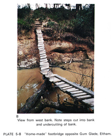
Work on paper (Sub-Item) - Photograph, Home-made footbridge across Diamond Creek, opposite Gum Glade, Eltham
Colour photograph of home-made footbridge across the Diamond Creek opposite Gum Glade, Eltham. View from west bank. Note steps cut into bank and undercutting of bankeltham, diamond creek, footbridge, gum glade, creek bank -
 Eltham District Historical Society Inc
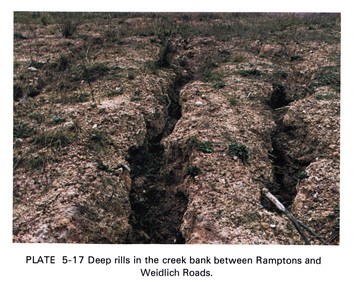
Work on paper (Sub-Item) - Photograph, Deep rills in the creek bank between Rampstons and Weidlich Roads
Colour photograph of deep rills in the Diamond Creek bank between Rampstons and Weidlich Roads, Eltham North. The shallow channels are cut into the soil by the erosive action of flowing water.eltham, creek bank, erosion, eltham north -
 Eltham District Historical Society Inc
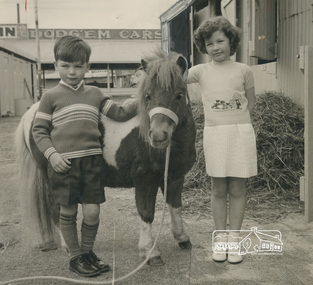
Work on paper (item) - Photograph, Little Models, 1961
Florence Ada Zull, known as Ada was an illustrator for the 'New Idea for Women" magazine. In 1961 she lived in Brunswick. From 1963 she and her husband Robert built a Alistair Knox designed house at 2 (lot 8) Metery Road, Eltham. In this issue Ada's son and daughter Susan model jumpers that were knitting competition prize winners at the Royal Agricultural Society of Victoria's Royal Show including Mrs L.M. Fullerton. (page 15) The opposite page features a photograph of film star Virginia Mayo and a beauty column. Original photo cut in half donated along with the issue of the magazine the photo was published in. royal agricultural society of victoria, royal melbourne show, l.m. fullerton, 1961, susan zull, susan bennett, zull family, knitting, pony, jumpers, virgninia mayo -
 Federation University Historical Collection
Book - Book - Scrapbook, Ballarat School of MInes: Scrapbook of Newspaper Cuttings, Book 74, June 1996 to August 1996
Collection of newspaper articles related to Ballarat School Of Mines.They cover activities and advertisements for staff. The papers concerned are The Courier, Ballarat, The Australian, The Age ad other region papers over the period of 1 June 1996 to 6 August 1996.Book with yellow cover, front, spiral bound. teaching positions advertised, pre-employment courses, courses available, enrolment for smb courses, counselling course may be lost, myma rance, father son graduate, phil allender, steve allender, building apprentices non payment, proposed changes to industrialrelations laws, brenda huggins winner of award, education is lifelong quest, smb graduation night, her majesty's 121st, food fit for a king, tony leonard, cuts fall on regional takes, administration students placed in workforce, art appreciation through theatre, tenders exceed funding, ray borner to olympic games, shane everard inspiration to all, network caters for chefs, judith beaton and jennifer martin, business studies, master painters' association, innovative businesses, building course for women, deanne jakiel's win a boon for kooris, dr ron wild, bright future for smb, young workers test their skills, melissa cameron, michael ronaldson mhr, peter morey work skill, angela cox, geoffrey richards, a legacy of design, jocelynne scutt - barrister, paralympians at smb, barry jones - alp, tafe cuts hit farmers, smb and red lion hotel - hospitality course -
Federation University Historical Collection
Book - Book - Scrapbook, Ballarat College of Advanced Education: Scrapbook of newspaper cutting, Book 9; March 1981 to September 1981
Newspaper cuttings relating to Ballarat College of Advanced Education. These are from various newspapers and include The Age, Ballarat Courier, The Australian, The Herald. The cuttings cover the period from 12 March 1981 to 1 September 1981. Many items are dedicated to the opening of Founder's Hall. . Book with grey cover, front. Image of draught horses. Spiral bound.employment advertisements, application for enrolment, outline of courses, wind power at bcae, cash outlook gloomy, concert to celebrate hall opening, grim look for teachers, opening of founder's hall, conferring of degrees at founder's hall, bhp chief at degree conferring, way to economic growth, education mission from china, library award to bcae student, helen hately, 50 years on, college enrolments climb, ronald potter winner of a e stohr medal of the institution of engineers, stop college cuts, political bias denied, protest at education cuts, graduate tom honeyman at bcae, college water supply, bcae field trip to western australia, lectures for industry, bill rofe, zig plavina, careers in sciences seminar, fitness for volunteers, study of walnuts a hit, siddons plan solar heating thrust, william charters inventor, jobs that go begging, shortage of engineers, careers seminar at bcae, morgan john retires, prints by students on show, pam dethridge, hard work pays off, labor pledge on education, unemployment in ballarat, bcae student dinner, advanced learning program for secondary students, first exhibition for eric collins, 30 escape bus crash, mining cadetship awarded to tom devries, bcae open day, technology week, getting the facts at bcae, memorial lecture, prof weston bate, tertiary education disadvantaged, goldrush miners relied on luck, more tafe funding 'not enough', equus ready for stage, mineral exports vital -
Federation University Historical Collection
Book - Book - Scrapbook, Ballarat College of Advanced Education: Scrapbook of newspaper cutting, Book 20; February 1987 to May 1987
Newspaper cuttings relating to Ballarat College of Advanced Education. These are from various newspapers and include The Age, Ballarat Courier, The Australian, The Herald. The cuttings cover the period from 23 February 1987 to 21 May 1987. . Book with green cover, front. Spiral bound.employment advertisements, application for enrolment, outline of courses, ballarat college of advanced education, bcae, health and safety, jim goulding, australian academy of hypnotic science, community officer, hamlet has wide appeal, paul tolton as hamlet, pottery work chosen for melbourne exhibition, tax hits enrolments, call to scrap fees, colleges oppose fees, john sharpham next bcae head, arts mean tourist dollars, courses professionally recognised, janet rubin theatre expert, exercise to music, mike whitesideand secret tunnel, joint showing of local artista, rick calvert civil engineering, sino-australian relations, enrolments, new orchestra ready for first night, adrian thomas, bso concert a success, paul tolton, the lost generation, john sharrock, david lance - winemaker, degrees herald future, karen bibby engineering medal, jack's final degree ceremony, 'full tertiary fees', college will give nurses 'merited new status', mathews defends library $2m cut, rodney brown wins geology award, royal australian nurses' federation, irene bolger - secretary, education changes, stayers and sprinters compared, koji hoashi - ceramics, paul mason community arts officer, "barefoot in the park" -
 Bendigo Military Museum
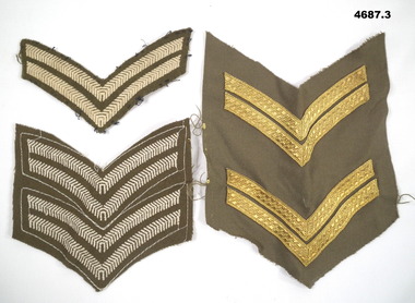
Uniform - RANK INSIGNIA, C.1960 - 1980
.1) is as used for Corporal, .2).3) these can be cut to make two sets of Corporal stripes, .1).2) these are work dress for Greens, .3) these are for Service Dress. Peter Dodd collection, refer Cat No 2436.2P.1) Rank insignia “Corporal”, dark brown with 2 off white “V” shape stripes. .2) Rank insignia same as in .1) except has 2 sets of Corporal stripes. .3) Rank insignia, 2 sets brown back ground with Gold Corporal stripes.rank insignia, corporal, accessory, uniforms -
 Federation University Historical Collection
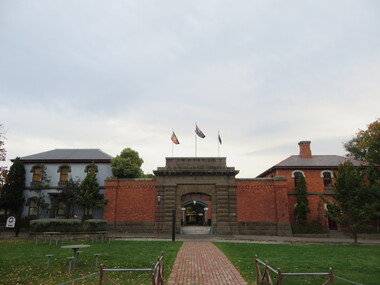
Photograph - Colour photograph, Former Ballarat Gaol Gates, 24/04/2017
The main gate to the former Gaol is a monumental work. The arch keystone facing Lydiard Street is beautifully executed. The gates and the iron lacework over the top are distinctive.The arch under the flyover is also distinctive; the basalt keystone appears to have been cut from one single block of stone. Most of the gaol has been demolished to allow the School of Mines Ballarat to expand onto the site. The remaining structures at the site include the main gate, warden's residence and governor's residence. These buildings are now used by Federation University.The main gate to the former Gaol is a monumental work. The arch keystone facing Lydiard Street is beautifully executed. The gates and the iron lacework over the top are distinctive.The arch under the flyover is also distinctive; the basalt keystone appears to have been cut from one single block of stone. gate, gaol, arch keystone, lydiard street, iron lacework, flyover, stone, basalt, warden's residence, governor's residence, ballarat school of mines, federation university, former ballarat gaol -
 Bendigo Military Museum
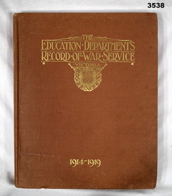
Book - BOOK, WAR SERVICE WW1, The Education Department's Record of Service Victoria 1914-1919, c.1921 - Forword dated 1.3.1921
From Forword: Contained in this book are the records of the work done by the schools of the Education Department of Victoria.Hard cardboard cover, orange buckram with gold print on front & spine. 304 pages, cut, faint speckled edge, white. Illustrated black / white photos & illustrations. End papers are dark brown. Handwritten in black ink on page before title page: “Sapper Henry J Collins”book, service, education department, victoria -
 Bendigo Military Museum
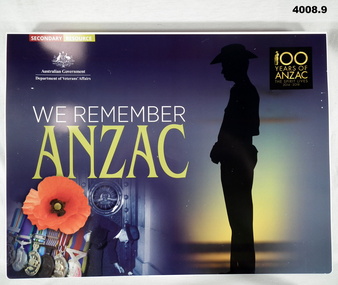
Education kit, Department of Veterans Affairs, WE REMEMBER ANZAC, 2) 2014, .4) 2014, .5) 2014, .6) 2014
WE REMEMBER ANZAC - 100 years of ANZAC - THE SPIRIT LIVES 2014-2018 - SECONDARY RESOURCE .1) .2) 'WE REMEMBER ANZAC' .3) 'COMMEMORATIVE CEREMONY' .4) 'Memories & Memorabilia - Recognising and Preserving Australia's War Heritage' .5) 'Candour. Stories in the words of those who served 1914-1918.' .6) Over a Century of Service 2015 (Calendar) .7) 'ANZAC CENTENARY' .8) 'ANZAC PORTAL' .9) '2015 Anzac Day School's Awards'.1) Box folder - cardboard, white & gold print front, spine, back. Illustrated - collage colour photographs - medals, poppy, rising sun badge, soldier in silhouette. .2) Softcover, cardboard with fold in front flap, white & gold print, spiral bound, colour collage photographs - poppy, medals, troops. Pages - 86 pages, cut, plain, white, illustrated black & white, colour photographs, work sheets. .3) DVD inside cover flap. .4) Soft cover, cardboard, spiral bound, black, print front, illustrated sepia photograph soldier with letter and slouch hat. Pages - 88 pages, cut, plain, white, illustrated black & white, colour photographs, posters. .5) Soft cover, cardboard, white print front & back, illustrated - collage colour and sepia photographs of service personnel, letters, pens, brooch. Pages - 56 pages, cut, plain, white, illustrated colour, black & white photographs, medals, paintings. .6) Calender - soft cover, cardboard, light brown and black print front and back. Illustrated - sepia and colour - in silhouette - Troops of 1st Australian Division and members of 4 RAR. Pages - cut, plain, white, illustrated colour, black & white photographs from Boer War to Afghanistan. .7) .8) Card, cardboard with Webkey attached. Card - white & dark red print, small colour, sepia illustrations. .8) Key - metal with words printed - 'ANZAC PORTAL'. In plastic pocket. .9) Leaflet - lightweight cardboard black, white, yellow print front and back. Illustrated - black & white photograph of troop ship dockside. educational kit, anzac centenary -
 Bendigo Military Museum
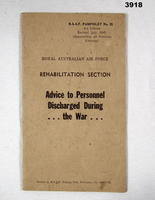
Literary work - PAMPHLET, Advice to Personnel Discharged During the War, 7.1945
RAAF pamphlet No 25 issued by the Rehabilitation Section of the RAAF to provide advice to personnel discharged during WWII. Item re Frederick Gardner DAVEY DFC No 410533 RAAF. Refer Reg No 3536P for his service details.Brown, card cover. 16 cut edged pages with black print on all. Pages stapled to the cover. Title on cover.rehabilitation, raaf -
 Bendigo Military Museum
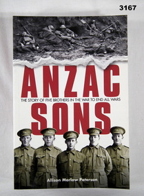
Book - BOOK WW1, Big Sky Publishing Pty Ltd, ANZAC Sons, 2014
The story of Five brothers in the war to end all wars. ANZAC Sons is composed from a collection of over 5 hundred letters & postcards written by the brothers who served.. This compelling true story was compiled by the grand daughter of a surviving brother.Soft cardboard cover, red & black print on front, spine & back. Sepia photo of five soldiers in uniform on front cover together with black & white photo of a trench scene. Back cover has a black & white photo of soldiers & a building. 688 pages, cut plain paper, illustrated with black & white photos & maps. Collection of letters & postcards.Front fly leaf handwritten in black ink: “The Bendigo RSL Museum.Thank you for the inspiring work you do to ensure future generations will always remember the great sacrifices of our forebears. Allison”books-biography, military history-army, photography-photographs, anzac, sons -
 Bendigo Military Museum
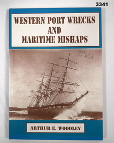
Book - BOOK, MARITIME, Arthur E Woodley, Western Port Wrecks & Maritime Mishaps, 1992
Soft cardboard cover. Brown print on front & spine, black print on back. Background colour aquamarine with front sepia photo of sailing ship. Back has 2 photos of the Cowes ferry. 103 pages, cut plain, off white. Illustrated with black & white photos & maps. Page XV has yellow highlighter pen applied to 2 sentences. Opposite p1, handwritten in blue ink on lined notepaper taped to page: “MIRANDA 1852, LADY MILDRED 1909, SEAGULL, CARPENTARIA, AT. * HARDWOOD. AIR. PORT, AMSTERDAM. FIVE (BEACHED), BUILT 1948. WORKED, YARRA RIVER, DIESEL MOTORS TOO BE RESTORED, * TOORADIN”book, maritime, wrecks, western port -
 Bendigo Military Museum
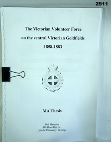
Literary work - MANUSCRIPT, Bob Marmion, The Victorian Volunteer Force on the Central Victorian Goldfields 1858 - 1883
Photocopy of original held by Castlemaine Art Gallery & Historical Museum. The inscription is the Castlemaine Museum's Registration No & location code.Manuscript, M A Thesis. Plain A4 paper with cut edges, 144 pages with black & white illustrations. Pages secured with a metal clip.Page (ii) top R hand corner: “3247 S3 C/F5”documents - education, military history - volunteer forces -
 Bendigo Military Museum
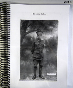
Literary work - DIARY WW1, It's About Jack, Post 2000
The diaries of PTE JOHN EDWIN BALL 3126A 48th Battalion 8th Reinforcement. Diary was transcribed by Michael Rohde, husband of J E Ball's grand daughter, Heather.Spiral bound with clear front cover & black card back cover. A4 plain paper with cut edges. 330 pages with black & white illustrations. Contains photocopies of original diary entries with typed transcripts.documents - diaries, military history, 48th -
 Bendigo Military Museum
Book - BOOK, POW’S, Organised by JP, The Death Railway & River Kwai Bridge
Book details the construction of the Thai Burma Railway & the bridge over the Rivew Kwai. Contains detailed photos & drawings. Taken from an oration by Fred Seiker in which he recalls the conditions under which the POW's lived & worked.Soft cover illustrated front & back with colour & black & white photos. 60 pages with cut edges. Bound with staples. Stamped inside front & back covers: Bendigo District RSL Sub Branch books-military-history, civil engineering/railways, river kwai, burma -
 Bendigo Military Museum
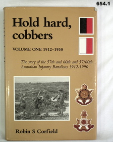
Literary work - BOOK, 1) Hold Hard, Cobbers Vol. 1 1912 - 1930 .2) Hold Hard, Cobbers Vol 2 1930 -1990, 1992
Two volumes detailing the story of the 57th, 60th and 57/60th Australian Infantry Battalions from 1912 to 1990. Donated by Frederick Ernest Addlem VX142253 57/60th Batt Refer Cat No 432.2 for his service history and 937P.Both volumes of Hold Hard, Cobbers. Both are hardcover with illustrations and illustrated dust jackets. .1 288 page, cut edged. Brown buckram and brown dust jacket. .2 352 page, cut edged. Green buckram with green dust jacket.Both items, on front end paper "Presented from the 57/60 Battalion (AIF) Association to the Bendigo RSL by Fred Addlem 1996"books, military, ww2 -
 Federation University Historical Collection
Article - Catalogue package, Creativity Released, Advanced Diploma of Graphic Design, 2010, 2010
Unprinted, forme-cut black folder, triangular window, sealed with triangular sticker containing a suite of A5 (148 x 210mm) cards promoting works of University of Ballarat, Advanced Diploma of Graphic Design (2 years) students. Contains 15, two-sided A5 cards, most featuring student work. Reverse of first card lists 12 graduates for 2010. Introduction by Paul Mah (co-ordinator / teacher). Teaching staff listed as Sam Harmer, Jill Hyatt, Slena Shillito, Travis Price, Ben Sanders, Anthony Woodward, Paul Mah, Alister Heighway, Peter Lambert, James Baker. Printed by Sovereign Press. Pack by Bennet-Meyer Packaging. One card features supporting sponsors Unprinted, forme-cut black folder, triangular window, sealed with triangular sticker containing a 15 A5 cards promoting student work.Promotional catalogue (pack of A5 cards) for graduating students of the University of Ballarat (TAFE), Advanced Diploma of Graphic Design. Unprinted, forme-cut black folder, triangular window, sealed with triangular sticker containing a 15 A5 cards promoting student work.university of ballarat, federation university, graphic design, tafe, advanced diploma, arts academy, camp street campus -
Federation University Historical Collection
Article - Catalogue package, Creativity Released, Advanced Diploma of Graphic Design, 2010, 2010
Unprinted, forme-cut black folder, triangular window, sealed with triangular sticker containing a suite of A5 (148 x 210mm) cards promoting works of University of Ballarat, Advanced Diploma of Graphic Design (2 years) students. Contains 15, two-sided A5 cards, most featuring student work. Reverse of first card lists 12 graduates for 2010. Introduction by Paul Mah (co-ordinator / teacher). Teaching staff listed as Sam Harmer, Jill Hyatt, Slena Shillito, Travis Price, Ben Sanders, Anthony Woodward, Paul Mah, Alister Heighway, Peter Lambert, James Baker. Printed by Sovereign Press. Pack by Bennet-Meyer Packaging. One card features supporting sponsors Unprinted, forme-cut black folder, triangular window, sealed with triangular sticker containing a 15 A5 cards promoting student work.As per parent record, but opened. Promotional catalogue (pack of A5 cards) for graduating students of the University of Ballarat (TAFE), Advanced Diploma of Graphic Design. Unprinted, forme-cut black folder, triangular window, sealed with triangular sticker containing a 15 A5 cards promoting student work.university of ballarat, federation university, graphic design, tafe, advanced diploma, arts academy, camp street campus -
Federation University Historical Collection
Book - Book - Scrapbook, Ballarat School of MInes: Scrapbook of Newspaper Cuttings, Book 6, July 1979 - December 1979
Collection of newspaper articles related to Ballarat School Of Mines.They cover activities and advertisements for staff. The papers concerned are The Courier, Ballarat, The Australian, The Age over the period of 03/07/1979 to 03/12/1979Book with deep red and white cover back and front, spiral bound. staffing advertisements, remedial teachers at smb, courses at smb, smb community resource centre open, smb music centre, smb farm course, report comdemns training, country kids get a raw deal, smb raft race, apprentice week, work and pleasure trip to snow for smb students, apprentice safety seminar at ballarat, val d'angri and "inkle weaving", the best of both worlds, smb weaving demonstration, many apprentices lack reading and number skills, teachers upset at mystery cut, centenary ceremony for smb gardens, gardens and art linked, indonesian visitors at smb, a.l.p.moves on new technology, problems of remedial teaching -
Federation University Historical Collection
Book - Book - Scrapbook, Ballarat School of MInes: Scrapbook of Newspaper Cuttings, February 1979 - 1980
Collection of newspaper articles related to Ballarat School Of Mines.They cover activities and advertisements for staff. The papers concerned are The Courier, Ballarat, The Australian, The Age over the period of February 1979 to 1980. Items have appeared in other books, mainly Item 31009Book with deep red and white cover back and front, spiral bound. staffing advertisements, remedial teachers at smb, courses at smb, smb community resource centre open, smb music centre, smb farm course, report comdemns training, country kids get a raw deal, smb raft race, apprentice week, work and pleasure trip to snow for smb students, apprentice safety seminar at ballarat, val d'angri and "inkle weaving", the best of both worlds, smb weaving demonstration, many apprentices lack reading and number skills, teachers upset at mystery cut, centenary ceremony for smb gardens, gardens and art linked, indonesian visitors at smb, a.l.p.moves on new technology, problems of remedial teaching -
 Federation University Historical Collection
Photograph - Sepia photograph, Benson & Stevenson, Emma Eliza Jane Phillips, c1860's
Emma was one of the first white children born in the Barrabool Hills (Geelong) to parents Richard and Elizabeth Phillips. Emma Eliza Jane Phillips was one of the first white children born in the Barrabool Hills (South Geelong) in the Port of New South Wales on 25/04/1844 and died at "Gracedale" Yendon 12/10/1925, age 81. Emma was the daughter of Richard Price Phillips and Elizabeth Anne Goodenough. Richard, originally a coach plater, was the licensee of "The Thistle Inn", a small hotel on the corner of Corio and Yarra Streets. Elizabeth appears to have had a dressmakers shop around the corner in Yarra Street. Emma married Thomas Watson in Ballarat in 18--? Thomas William Watson was born in Harston, Cambridge, England on10/11/1838 and died at "Gracedale", Yendon, Victoria, Australia 27/04/1920, age 81. He came to Australia seeking gold but instead of finding a fortune he worked for the Victorian Railways. After living in Sebastapol and Ballarat North they settled on a small farm at Yendon named "Gracedale" They were married in Ballarat at Saint Paul's Church of England in Ballarat East. Emma sang in the choir and was a member of the Ballarat Philharmonic Society. They first lived in Sebastapol, then Crompton Street, Ballarat North before building a house at Yendon. Thomas and Emma had 10 children, five boys and five girls, also rearing 3 grandchildren. Thomas and some of his sons ( including John Richard) helped to cut the original steps at Lal Lal to the bottom of the Lal Lal Falls.Photograph of a woman seated at a table with one elbow resting on books. Her jewllery has been hand painted in gold and the top book cover in green. C1860Front: Benson & Stevenson 108 Elizabeth Street Melbourne Copies can be obtained at any time Verso: Emma Eliza Jane (Phillips) Watson; 1844-1925; 81yrs; Died "Gracedale" Yendon, Vic; Born - South Geelong/Barrabool Hills; Dad's (John Richard Watson) motheremma eliza jane phillips, emma eliza jane watson, barrabool hills, yendon, thomas watson, richard price phillips, elizabeth goodenough, lal lal falls -
Federation University Historical Collection
Book - Book - Scrapbook, Ballarat School of MInes: Scrapbook of Newspaper Cuttings, Book 41, October 1989 to December 1989
Collection of newspaper articles related to Ballarat School Of Mines.They cover activities and advertisements for staff. The papers concerned are The Courier, Ballarat, The Australian, The Age over the period of 12 October 1989 to 29 December 1989.Book with yellow cover, front, spiral bound. teaching positions advertised, pre-employment courses, courses available, enrolment for smb courses, photographs ballarat life, edan bradley, sarah bolster, special entry scheme, access program for women, anthony wonish silver medal winner, kathryn wilson first r j young scholarship, promoting opportunities at smb, ann mccaffrey, smb open day, training structure charts, women speak on small business, radiotherapy machine needed in ballarat, leesa arnott hairdressing apprentice, aim for 500 apprentices, cuts to performing arts?, smb juggles plan for cost cutting, smb advanced certificate in ceramics, david addy winner of edgar bartrop scholarship, literacy volunteer graduates, course offers youth hope of work, brickies of the future, adult literacy program cuts, advanced ceramics exhibition, students organise deb ball, government education bill, library named after jack barker, julie oldham wins computer service award, wendy caple and allan lion horticulture students, prejudice attitudes -
Frankston RSL Sub Branch
Trouser, Bellbottom, Royal Australian Navy 1960's
, bell-bottoms did not become part of the standard uniform for the Royal Navy until the mid-19th century.These "bell-bottoms" were often just very wide-legged trousers, unlike the modern version of bell bottoms, which are cut with a distinct bell shapePart of complete uniform donated by H.M.A.S.Cerberus on Mornington Peninsula,Many sailors would have spent leave time in this cityA pair of sailor's white bellbottom pants as issued by the RAN for everyday work wear. W J READ WR 1584 not yet logged -
 Flagstaff Hill Maritime Museum and Village
Book - Reference Book, Mr Salmon (Thomas Salmon) et al, Modern History: or, the Present State of All Nations. Vol III, 1746
The author was Mr. Salmon (Thomas Salmon), (1679-1788). The fly page of the book has the following writing in red and black print: "Describing their Respective Situations, Persons, Habits, and Buildings; Manners, Laws and Customs, Religion and Policy; Arts and Sciences, Trades, Manufacturers and Husbandry; Plants, Animals and Minerals. Illustrated with Cuts and Maps, accurately drawn according to the Geographical Part of this Work by Herman Moll. Third Edition with considerable Additions and Improvements, interspersed in the Body of the Work: Also the History and Revolutions of each Country, brought down to the present Time. " Thomas Longman founded his publishing firm in 1724 in London by the name Longman. In August of that year, he bought the two shops and goods of William Taylor and set up his publishing house there at 39 Paternoster Row. The shops were called Black Swan and Ship, and it is said that the 'ship' sign was the inspiration for Longman's Logo. After many changes of name and management, including the name T Longman and T Shewell in 1746. The firm was incorporated in 1926 as Longmans, Green & Co. Pty Ltd. The firm was acquired by Pearson in 1968 and was known as Pearson Longman or Pearson PLC. The book is part of Flagstaff Hill's Pattison Collection, a large group of books and records, some of which are rare and valuable. The collection was originally owned by the Warrnambool Mechanics' Institute, which was founded in 1853 and is named after Warrnambool's Public Librarian, Ralph Pattison.The book is significant for its age – it is one of the oldest books in Flagstaff Hill’s collection, published in 1746. The book is a record of Modern History at that time and allows studying and comparing those times with today. The book is important for its connection with the London publisher T Longman and T Sewell, who only operated under this name between 1745 and 1747. The firm has been established for over two centuries and is renowned for publishing encyclopedias, dictionaries, books on English grammar, textbooks, poetry, reference books, novels, magazines and more. The book has additional importance for its connection to the Pattison Collection, which, along with other items at Flagstaff Hill Maritime Village, was originally part of the Warrnambool Mechanics' Institutes’ Collection. The Warrnambool Mechanics’ Institute book collection has historical and social significance for its strong association with the Mechanics Institute movement and its important role in people's intellectual, cultural and social development throughout the latter part of the nineteenth century and the early twentieth century. The collection of books is a rare example of an early lending library and its significance is enhanced by the survival of an original collection of many volumes. The Warrnambool Mechanics' Institute’s publication collection is of both local and state significance.Modern History: or, the Present State of All Nations Vol III Author: Mr. Salmon (Thomas Salmon) Illustrator: Herman Moll Publisher: T Longman and T Shewell in Paternoster Row, London Date: 1746 (MDCCXLVI), 3rd Edition Further Information: In Three Volumes, Vol. III The large hardcovered book has reinforcing on the spine and corners. The cover is very well worn and has remnants of a coloured design. The fly page is printed in red and black ink and has a long description of the contents. Inside the cover is printed a Coat of Arms. There is a stocker on the inside cover, The book is part of the Pattison Collection.Label on the spine "RH F910 SAL" Sticker on the pastedown front endpaper "Corangamite Regional Library Service" Printed on pastedown front endpaper "Coat of arms, crown above a shield with an inverted V with three stars on it" Sticker on front loose endpaper "Coat of arms, with "F C G Ritso"flagstaff hill, flagstaff hill maritime museum and village, warrnambool, maritime museum, maritime village, great ocean road, shipwreck coast, pattison collection, ralph eric pattison, warrnambool mechanics’ institute, mechanics’ institute library, warrnambool library, free library, corangamite regional library service, mr salmon, thomas salmon, 18th century, 1746, history, geography, social studies, culture, maps, modern history, present state of all nations vol iii, herman moll, t longman and t shewell, social history