Showing 107 items
matching dairy buildings
-
 Merbein District Historical Society
Journal - Quarterly, Merbein Historian - Quarterly Journal of MDHS - No 43 (2 copies), Mar.2011
mark (cr) eckel., bernadette wells, a self drive tour of historic sites - buildings - places of interest, hazel dowsley, merbein higher elementary school staff 1958, mavis mary bennett, jack bennett, ray slade, joan (nee goetz) dodds, easter camp memories 1952 - 1956, shirley lake (racquets), merbein dairy, dora's diaries, joyce bosenberg (letter) , merbein cheer up club, barbara downing, richard neeman, dorothy nice, laurel nice, vi nice, phillip day, arthur mcmahon, douglas hore, richard appleby, percy appleby, appleby vintage equipment, samuel brindsen, jack treen, albert hunt, elwood mead, merbein common -
 University of Melbourne, Burnley Campus Archives
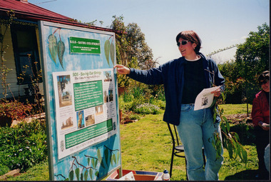
Photograph - Colour, Dairy, 1985
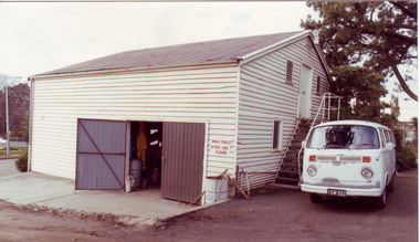
... Building.) dairy herd glenormiston milking shed machinery shop ...Note by T.H. Kneen," After the transfer of the small dairy herd to Glenormiston and later Longerenong the milking shed was modified to serve as a machinery shop. Late in 1990 and early in 1991 it was converted for use as the Horticultural College Centenary Centre and as a new home for the Horticultural Shop. Half the space on ground floor level was devoted to a display "A Centenary of Horticultural Education." The old loft area was fitted out as the office for the Executive Officer for the Centenary Celebrations and the storage of archival material." (In 2009 the shop closed and the archives were removed to the Administration Building.) Colour photograph. Former dairy used as a garage prior to 1990 renovationdairy herd, glenormiston, milking shed, machinery shop, horticultural college centenary centre, horticultural shop, cows, garage, dairy, dairy shed, centenary centre, longerenong -
 Eltham District Historical Society Inc
Photograph - Digital Photograph, Marguerite Marshall, Stuchbery Farm dairy, 14 March 2008
... Stuchbery dairy Stuchbery Farm farm buildings Yarrambat Plenty Gorge ...Stuchbery Farm was situated on the Plenty River bounded by Smugglers Gully to the north and La trobe Road, Yarrambat, to the east. Alan and Ada Stutchbery moved to the valley in 1890, first living in a tent where four children were born. Alfred built a home and outbuildings around 1896. They planted an orchard, then a market garden and developed a dairy. Published: Nillumbik Now and Then / Marguerite Marshall 2008; photographs Alan King with Marguerite Marshall.; p179 The dramatic steep-sided Plenty Gorge lies along the divide of two geological areas, and separates the Nillumbik Shire and the City of Whittlesea. On the Nillumbik side are undulating hills and sedimentary rock, and in Whittlesea, lies a basalt plain formed by volcanic action up to two million years ago. This provides the Plenty Gorge Park with diverse vegetation and habitats, making it one of Greater Melbourne’s most important refuges for threatened and significant species. The park, established in 1986, consists of around 1350 hectares, and extends 11 kilometres along the Plenty River, from Greensborough to Mernda. It provides a wildlife corridor for around 500 native plant and 280 animal species. The area’s plentiful food and water attracted the Wurundjeri Aboriginal people and then European settlers. By 1837 squatters had claimed large runs of land for their sheep and cattle. The Plenty Valley was among the first in the Port Phillip District to be settled - mainly in the less heavily timbered west - and was proclaimed a settled district in 1841. But by the late 1880s, the settlers’ extensive land clearing for animal grazing, then agriculture, depleted the Wurundjeri’s traditional food sources, which helped to drive them away. Many Wurundjeri artefacts remain (now government protected), and so far 57 sites have been identified in the park, including scarred trees, burial areas and stone artefacts. Pioneer life could be very hard because of isolation, flooding, bushfires and bushrangers. Following the Black Thursday bushfires of 1851, basalt was quarried to build more fire-resistant homes. Gold discoveries in the early 1850s swelled the population, particularly around Smugglers Gully; but food production made more of an impact. In the late 1850s wheat production supplanted grazing. In the 1860s the government made small holdings available to poorer settlers. These had the greatest effect on the district, particularly in Doreen and Yarrambat, where orchards were established from the 1880s to 1914. Links with a prominent early family are the remains of Stuchbery Farm, by the river’s edge bounded by Smugglers Gully to the north and La Trobe Road, Yarrambat, to the east. The Stuchberys moved to the valley in 1890, and the family still lives in the area. In 1890, Alfred and Ada first lived in a tent where four children were born, then Alfred built the house and outbuildings around 1896. They planted an orchard, then a market garden, and developed a dairy. The family belonged to the local Methodist and tennis communities. Their grandson Walter, opened the Flying Scotsman Model Railway Museum in Yarrambat, which his widow, Vi, continues to run. Wal was also the Yarrambat CFA Captain for 22 years until 1987. Walter sold 24 hectares in 1976 for development - now Vista Court - and in 1990, the remaining 22.6 hectares for the park. Remaining are an early stone dairy and remnants of a stone barn, a pig sty and a well. Until it was destroyed by fire in 2003, a slab hut stood on the Happy Hollow Farm site, at the southern end of the park. The hut is thought to have been built in the Depression around 1893. This was a rare and late example of a slab hut with a domestic orchard close to Melbourne. Emmet Watmough and his family first occupied the hut, followed by a succession of families, until the Bell family bought it around 1948. There they led a subsistence lifestyle for 50 years, despite encroaching Melbourne suburbia. The Yellow Gum Recreation Area includes the Blue Lake, coloured turquoise at certain times of the year. Following the 1957 bushfires, this area was quarried by Reid Quarries Pty Ltd for Melbourne’s first skyscrapers, then by Boral Australia. However in the early 1970s water began seeping into the quarry forming the Blue Lake and the quarry was closed. The State Government bought the site in 1997 and opened it as a park in 1999.This collection of almost 130 photos about places and people within the Shire of Nillumbik, an urban and rural municipality in Melbourne's north, contributes to an understanding of the history of the Shire. Published in 2008 immediately prior to the Black Saturday bushfires of February 7, 2009, it documents sites that were impacted, and in some cases destroyed by the fires. It includes photographs taken especially for the publication, creating a unique time capsule representing the Shire in the early 21st century. It remains the most recent comprehenesive publication devoted to the Shire's history connecting local residents to the past. nillumbik now and then (marshall-king) collection, ada stuchbery, alan stuchbery, dairy, stuchbery farm, farm buildings, yarrambat, plenty gorge park -
 Ringwood and District Historical Society
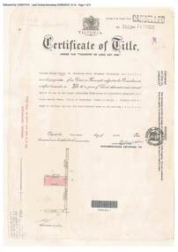
Document, Certificate of Title - W.G. Carter, Grandview Grove, Warranwood, Victoria, (later Bemboka Road) - part of Crown Section Twenty, Parish of Warrandyte, County of Evelyn - 1947
A4 copies of Landata Victoria Historical Search documents - Vol 7052 Fol 1410222. Includes Carter Family Tree property notes. William George Carter of Grandview Grove Ringwood, Nurseryman, is now the proprietor - three acres or thereabouts shown on map (12202a) - 14th March, 1947. Transfer B284834 Registered 21 September, 1961 - 1 acre shown on map (12202c) north of Plymouth Road. NOTES ON GRANDVIEW GROVE PROPERTY (Carter Family Tree extract) The Grandview Grove property was purchased by William (Bill) and Doreen Carter in 1947 as three acres of uncleared bushland. They had a 2 bedroom fibro-cement house built on the land which they informally called "Willoreen". With Doreen looking after sons Peter (born in 1940) and Robin (born in 1950), Bill worked locally at Croydon Dairy. The family spent much of their spare time clearing the land, where Bill then grew and sold fruit, flowers and berries, particularly strawberries, as a hobby and to supplement their income. Bill continued to do so while Peter and Robin were growing up, and after Doreen died in 1958. In 1961 Bill sold one of the three acres to one of his seven sisters, Grace, who lived in Kew but later moved to Rosebud and sold the land without ever building on it. During the 1960s, Grandview Grove was renamed Bemboka Road. After retiring as a milkman, Bill moved to Rosebud, Vic, and in 1977, sold the property to the Anglican Church, who were looking to invest in the site in anticipation of proposed future residential development in the area. As nearby properties were subdivided during the 1980s, the house, which the Church had initially utilised as low-cost family accommodation, was modified internaly to become a church/Sunday school. By the early 2000s, construction of a contemporary-design church and carparking area between the house and street alignment had been completed but the house remained as a detatched meeting room until falling into disrepair and was eventually demolished around 2010. -
 Stawell Historical Society Inc
Photograph, Whitehall Property Greens Creek
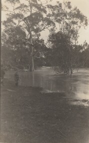
Hutchings family 1. Wimmera River in flood below Whitehall running a banker c. 1920. Ted & Col Hutchings in foreground. 2. Wimmera River in flood looking downstream. No date but possibly same time as no. 1. from same place. 3. Looking over the Wimmera River to Island paddock towards Greens Creek 4. Wimmera River half a banker at Whitehall 5. Wimmera River in flood upstream from carpenter's shop looking towards engine house at Whitehall 5a. Wimmera River in flood. Left to right - blacksmith shop and carpenters' shop. 5b. Taken from the same spot with Emily & Ada Hole, E G (Ted) & Col Hutchings. Blacksmith shop & carpenters' shop, Whitehall. 5c. Wimmera River upstream from the carpenters' shop. Foreground is possibly Belladonna lilies which were all over the river bank in 1992. Whitehall. 5d. Looking downstream towards the loose boxes, Whitehall. 5e. Blacksmiths' shop and carpenters' shop from the pumping station. Wimmera River, Whitehall. 6. Wimmera River in flood at Whitehall. 7. Wimmera River half a banker in front of old hut at Whitehall. 8. Wimmera River Emily Hayes, Edward G (Ted) Hutchings & Colin J Hutchings. 9. Morrl-Morrl - Greens Creek Road opposite back paddock. Whitehall. Black Ford in distance. c. 1919 10. Whitehall woolshed north east aspect, Drive to the right of photo 11. Whitehall woolshed - north east aspect showing the drive to the right 11a. Whitehall woolshed - north aspect 11b. Same tree near woolshed 11c. Same tree again in centre, other trees came up after the 23 flood. Woolshed to the right out of photo. 12. Whitehall woolshed - south aspect, sheep entrance end 13. Whitehall. left to right, Stackyard, stables in the centre and the Wimmera River behind following the trees. 14. Whitehall horse paddock c. 1920. left to right, Machinery shed, stable in the centre. Homestead to the right in distance. There is no windmill. 15. Load of wool from Whitehall woolshed to right. 16. Whitehall c. 1920 before the windmill. left to right, garage and mens' hut. Wimmera river runs along the tree line. 16a. Stables, garage and mens' hut after the construction of the windmill. River behind. 17. Whitehall c. 1922. Note windmill addition. Garage to left, Mens' Hut to right. Jack Donnelly & Edward G (Ted) Hutchings with pet lambs. River behind trees. 18. Whitehall gardens. Summer house to the right, pine tree lined drive in the centre background. Ted & Col Hutchings on the lawn. C. 1920 19. Edward G. (Ted) & Colin J. Hutchings in Whitehall garden. Wimmera River in the background. The building behind the fence is the carpenters' shop which the family lived in while house was rebuilt after fire 15 Jan 1877 20. Whitehall c. 1920. left to right, cattle yard, killing house, Wimmera river behind the fence, and the loose box on the right. Black Orpington chooks in foreground. 21. Bay window (original blinds) in the master bedroom. Whitehall 20 Sep 1992 22. Master bedroom (original wallpaper) Joyce & Col Hutchings, Moyu, Ben & Rebecca Roe 20 Sep 1992 23. Col & Ted's bedroom (original) Marble mantlepiece had been removed. Whitehall. 20 Sep 1992 24. Whitehall kitchen. Large yellow meat oven to left of stove, bread oven far left, extreme right is oven where milk heated to skim cream. Chimney was a central one shared with meat oven. Bread oven chimney separate. 20 Sep 1992 25. Whitehall dairy, made of natural stone with dried brick corners. Entrance behind creeper which is over trellis. 20 Sep 1992. This building still remains in 1 Jun 2023 26. Inside charcoal lined meat cellar. Bottom right is concrete vat for pickling meat in brine. Top of brickwork slightly above ground level. Whitehall 20 Sep 1992 27. Fire foreground was stable flooring which was to left of photo. Machinery shed (thatch roof). 4 posts far left remains of cowshed. Large post in centre foreground is the gate post of corral. River to right. 20 Sep 1992 28. Whitehall machinery shed. Posts on far right are cow shed. Over the river is the island paddock. Wimmera river runs behind machinery shed. 20 Sep 1992 29. Posts of 10 sided corral. Killing house by side of gum tree in centre of photo on far side of corral. To left is one of the bales of the cowshed. Whitehall. 20 Sep 1992 29a. Similar photo in the 1920's. To the right is horsebreaking corral, then cow shed, loose box, haystacks and stable on left. Whitehall. 30. Dining room fire place put in the open fire of the mens' hut, only the chimney remains. To the left is the drive & river. Rebecca Roe, Col Hutchings granddaughter. 20 Sep 1992 30a. Looking down the Whitehall Drive. Mens' Hut (Jack Donnelly in doorway) and garage far left. 1920's 30b. The Drive, Whitehall taken from in front of the mens' hut. Wimmera River on the left. Gum tree on left still there 20 Sep 1992. 30c. Reverse from 30a. Whitehall drive from the front gate looking towards the mens' hut and garage. c. 1926 30d. Curly Donohue leaving for Warracknabeal. Ex mail contractor Omeo to Bright Victoria. C. 1926 30e. Looking down the drive towards front gate. Mens' hut on the right, river on the left. 31. Whitehall from the side. Building in centre behind David is separater room. 2 roomed hut to left of separater room and remains of mens' hut chimney. Photo 16 taken from similar spot. 20 Sep 1992 32. Benjamin Roe (Col Hutchings grandson) in the Carpenters' shop. The family lived in this building after the fire in the 1870's. Whitehall 20 Sep 1992 33. Ford across the Wimmera River at Whitehall (River abt. 5 feet higher than normal) 20 Sep 1992 33a. Wimmera River, Whitehall 34. Site of old bridge before Col Hutchings time. Tree in foreground to right still has bolt from bridge work protuding. A large post was in the centre of photo to make equal distance. 20 Sep 1992 35. Entrance to the old ford. Colin J Hutchings & his daughter, Moyu Roe. Wimmera River, Whitehall 20 Sep 1992 36. Summer house at Whitehall 20 Sep 1992 looking down to the orchard, dark green trees in distance old fruit trees. 36a. Edward & Colin Hutchings in front of the Summer house, Whitehall c. 1921 36b. Summer house looking towards front gate. Whitehall. 36c. Grey thrush in nest box which can be seen in previous photo with summer house in the background. Whitehall. 36d. Summer house from the orchard side. Whitehall. 37a. South side of Whitehall. First window Edith Sutherland's room, 2nd window, Ted & Col's room, bay window master bedroom 38. Taken in middle of front path looking towards front gate. Edith Sutherland in garden. Date palm in centre, cotton palm to left. Whitehall c. 1920's 38a. Garden at Whitehall taken from near the cotton palm. 39. Whitehall 20 Sep 1992 Bay window-master bed, small window to r. of bay-Colin Hutchings born in, front door, window to right-dining room, round the corner- drawing room, window on right, spare bed, verandah on left is spare bed. 39a. Whitehall c. 1920's Date palm on the right. 39b. Win, Colin T & Colin J Hutchings. Date palm in background. Whitehall 1943 39c. Edward George, Colin Thomas, Elizabeth Ambler & Colin James Hutchings wearing RAAF uniform. Date Palm in background. Whitehall c. 1943 39c. Front garden of Whitehall looking from the front right side of the house towards the drive & Wimmera River. Date palm on right, cotton palm on left 20 Sep 1992 40. Taken from bottom left corner of front garden looking towards the summer house. Cotton palm on right. River to the left. 41. Elizabeth A Hutchings beside master bedroom window. Whitehall c. 1920 42. Whitehall (photo of a painting by Wallace) owned by Colin T Hutchings 1982. 42a. Whitehall painting by Wallace after restoration now owned by Nick Hutchings 2021 42b. Whitehall c. 1923 42c. Taken from the side garden looking towards the right side of house. Front door is to the left out of photo. The cotton palm is to the left. c. 1923 43. Signpost showing Whitehall 20 Sep 1992, All ground up to the tree line behind the signpost was Whitehall property. 44. Colin T. Hutchings age 9 mths. Mar 1943 Whitehall 45. Colin James, Elizabeth Ambler & Edward George Hutchings. Front garden by the date palm, Whitehall c. 1939-40 45a. Colin James, Edward George, Edward Thomas Hutchings & E. Winifred May & Barney (dog) Whitehall. c. 1939-40. 45b. Colin James & Colin Thomas Hutchings during drought & World War ll c. 1944-45 in front of cotton palm, date palm to right. 46. Garden at Whitehall. Jack Donnelly on the hand mower. Cotton palm on left, date palm behind Jack and roof of carpenters shop to right. 47. Colin J Hutchings on tractor, E. Tom Hutchings behind. Whitehall, c. 1933 48. Jack Donnelly (Tad) & Colin J. Hutchings. Cotton palm to right. Whitehall c. 1917-18 49. Edward G (Ted) & Colin J Hutchings with cockatoo outside the dairy in rear garden. Whitehall c. 1923 50. Taken from the windmill looking across the roof of the mens' hut to the garden, orchard and drive in Winter time. House is behind the trees to right, Wimmera River to the left out of picture. Whitehall. 50a. Not labelled by Col Hutchings. It is an aerial shot looking towards the house in the trees & seems to be taken from the top of a tree...on the river side. 51. E. Tom Hutchings & George Chambers dam sinking. Whitehall. 51a. Tom Hutchings & George Chambers dam sinking. Whitehall. 51b. E. Tom Hutchings dam sinking. 52. Emily Hayes & Ada Hole (sisters) with Tom, Col & Ted Hutchings at the woolshed. 53. E T (Tom) Hutchings on reaper & binder. Whitehall. 54. Orchard looking towards the house. Carpenters' shop and river on the right. Whitehall. 54a. Orchard looking from the house, dark trees in background form part of the drive. 55. Grasshopper plague, Christmas Day 1933. Whitehall 56. Frost on the front lawn, Whitehall. 57. Little red hen & chicks with the river in the background 58. Edward (Ted) G. Hutchings muscovy ducks, hay shed and trees along the river in the background. 58a. Edward (Ted) G Hutchings muscovy ducks. 59. Swimming in the Wimmera River, either Ted or Col Hutchings in the foreground. 60. Looking towards the fowl house and pigsty, Whitehall. 61. Snake on the path, Whitehall. c. 1923 61a. E. Tom Hutchings killing a snake, Whitehall. c. 1923 61b. E. Tom Hutchings killing a snake, Whitehall. c. 1923 62. Notice of clearing sale, Stawell News & Pleasant Creek Chronicle on 5 Apr 1916 where the stock & whole of the household furniture was to be sold by James Hutchings widow. 63. Back to Greens Creek 7 Jun 1987 Colin J Hutchings left and Belle Kindred centre looking at photo 64. Back to Greens Creek 7 Jun 1987 Colin J Hutchings centre, Graham Stewart holding photograph on the right. 65. Colin J Hutchings & Bill Walker. Back to Greens Creek 7 Jun 1987 66. Colin J Hutchings delivering a speech before the plaque unveiling. Back to Greens Creek 7 Jun 1987 67. Graeme Williamson & Colin J Hutchings (2 'old boys') Greens Creek School Site 7 Jun 1987 68. Graeme Williamson talking to Moyu Roe (Hutchings) in background is May Williamson. Back to Greens Creek 7 Jun 1987 69. Greens Creek SS, Edward (Ted) & Colin J Hutchings attended. 70. Original students of first Greens Creek School 7 Jun 1987 Back row left 1. Kindred 3. Colin J Hutchings 4,5,6 not known 7. Graeme Williamson Sitting left 1. Not an original 2,3,4, not known 5. Belle Kindred 71. Terrier at Greens Creek State School 72. The new school students Back to Greens Creek 7 Jun 1987. Perry twins standing in centre and the teacher kneeling front left. 73. Will Rees water colour 1925 signature 74. Will Rees water colour 1925 75. Shearing at Kirkellar. Allen Simpson's 76. Back to Greens Creek 7 Jun 1987 Colin J Hutchings left and Belle Kindred centre looking at photo 77. Back to Greens Creek 7 Jun 1987 Colin J Hutchings centre, Graham Stewart holding photograph on the right. 78. Colin J Hutchings & Bill Walker. Back to Greens Creek 7 Jun 1987 79. Colin J Hutchings delivering a speech before the plaque unveiling. Back to Greens Creek 7 Jun 1987 80. Graeme Williamson & Colin J Hutchings (2 'old boys') Greens Creek School Site 7 Jun 1987 81. Graeme Williamson talking to Moyu Roe (Hutchings) in background is May Williamson. Back to Greens Creek 7 Jun 1987 82. Greens Creek SS, Edward (Ted) & Colin J Hutchings attended. 83. Original students of first Greens Creek School 7 Jun 1987 Back row left 1. Kindred 3. Colin J Hutchings 4,5,6 not known 7. Graeme Williamson Sitting left 1. Not an original 2,3,4, not known 5. Belle Kindred 84. Shearing at Kirkellar. Allen Simpson's 85. Terrier at Greens Creek State School 86. The new school students Back to Greens Creek 7 Jun 1987. Perry twins standing in centre and the teacher kneeling front left. Digital Copy of Parish Maps Kara Karahomestead -
 Flagstaff Hill Maritime Museum and Village
Photograph - Historical, building, Lighthouse Keeper's Quarters Warrnambool, Ca. 1917
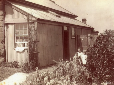
This photograph of the Warrnambool Lighthouse Keeper's Quarters was donated together with an accompanying letter written by John Lindsay on October 21st, 1997. The letter was addressed to Howard Nicholl, the Director of Flagstaff Hill at that time. The following information was gleaned from the contents of the letter and the labels attached to the photograph:- The photograph of the Cottage was taken in about 1917. The woman is Gertrude Shade, married to James Shade, who was the Warrnambool Town Council's Officer responsible for keeping records of Shipping activity entering and leaving the busy Port of Warrnambool. The couple and their children, Janet and William, were residents of the Assistant Lighthouse Keeper's Quarters at that time. The family is pictured in the garden on the west side of the building. A washhouse, these days referred to as a laundry, is behind the building and had already been removed when the Flagstaff Hill Planning Board had access to the site in 1972. The corrugated iron veranda was replaced in the 1980s with a smaller covered entry. Janet Shade married the man who lived across the road, Stewart Lindsay, in 1935. Stewart was employed by Nestle at the age of sixteen, working in the export department. He was acting Manager when the Manager became ill, supervising the loading of dairy products and biscuits into the holds of the waiting ships, where they were then exported to Indonesia. Many of the ships were registered in Liberia and the seamen were called 'lascar seamen, or Indian Sailors. Janet and Stewart had a son, John Stewart Lindsay, who was a Pharmacist, a member of the Warrnambool City Council, the Mayor of the City of Warrnambool, a former Director of Flagstaff Hill, and Chairman of the Flagstaff Hill Advisory Committee.This photograph has significance as a historical record of the Warrnambool Lighthouse Kerr'er's Quarters in 1917. The photograph connects the cottage to local families, to local industry, to the Port of Warrnambool, and to overseas exports from Warrnambool. Photograph from c. 1917 depicts the western side of the Warrnambool's Lighthouse keeper's Quarters constructed in bluestone, which was where the Assistant Lighthouse Keeper resided. The image shows the corrugated iron lean-to, and other rooms that were added to the original building after 1872, which were removed in the 1970s due to their poor condition. The members of the family pictured were residents at the time; Gertrude Shade (Mrs James Shade), her daughter Janet and her son William. Inscriptions are on the reverse and the accompanying envelope. Typed label "Gertrude Shade with William and Janet. Lighthouse Keeper's Cottage, Flagstaff Hill, Merri St Warrnambool" Stamp "John Stewart Lindsay, Pharmacist, --0 Thompson Street Warrnambool 3280" "HOWARD NICHOLL / FLAGSTAFF HILL / MERRI STREET" " KEEP OUT OF REACH OF CHILDREN / Lindsay's Pharmacy / 119 Liebig Street, Warrnambool / Tel. 5561 4310" [round symbol of mortar and pestle] Typed letter (from John Lindsay to Howard Nicholl, October 21 1997)flagstaff hill, warrnambool, maritime museum, shipwreck coast, great ocean road, lighthouse keeper's quarters, lighthouse keeper's cottage, gertrude shade, james shade, janet shade, john stewart lindsay, stewart lindsay, nestle, warrnambool exports, port of warrnambool, planning board, 1917, howard nicholl, william shade, export to indonesia, janet lindsay -
 Kiewa Valley Historical Society
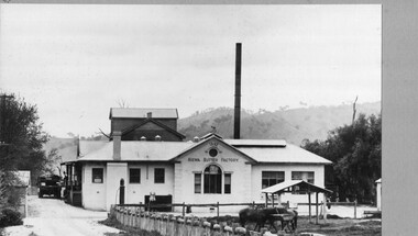
Photo - Kiewa Butter Factory 1892
Butter factory at Kiewa with creameries at Kergunyah and Gundowring met on 14th December 1892 and built it in 1893. In 1928 a new butter factory was built and a milk products factory was created in 1952The Kiewa Butter Factory employed a lot of people and supported the farmers in the Kiewa Valley.Black and white photo of Kiewa Butter Factory 1892. The photo was taken in 1932. The photo is glued to thick grey cardboard creating a frame. The photo is of a white building with a tall tower behind it. This photo is published on pages 45 and 89 of 'A History of the Kiewa Valley' by Esther Temple and David LloydWritten in biro bottom front of cardboard '1932'kiewa butter factory, creamery, dairy industry -
 University of Melbourne, Burnley Campus Archives
Album - Colour prints, Photograph Album Burnley College Buildings, 1981-1985
Collection of 34 photographs in a cardboard photograph album with plastic pages. Most stamped 20 Aug 1985 on reverse, Quad construction 1981.(1) Administration Building front entrance. (2) Administration Building front view. (3) Administration Building front centre. (4) Administration Building, back entrance, Hall end. (5) Administration Building, back centre. (6, 7) Student Amenities Building. (8) Quad 5. (9, 10) Library, front completed 1982. (10A) Library, back. (11) Nursery. (12) Nursery (13,14) Quads 2,3,4. (15) Quad 6 back. (16) Engineering (17) Library front from the Bull Paddock. (18) Dairy. (19) Principal's Garage, now Herb Garden. (20) Soil Bins old Nursery. (21) Old Nursery. (22) Greenhouse old Nursery. (23-25) Landscape Shed. (26) Orchard Shed. (27) Orchard Shed and Kiwi Fruit vine. (28,29) Plant Science Laboratory. (30) Energy Efficient Glasshouse old Nursery. (31) Glasshouse old Nursery and Potting Shed. (32) Energy Efficient Greenhouse old Nursery. (33) Potting Shed old Nursery.quad construction, administration building, student amenities, library, nursery, bull paddock, dairy, principal's garage, herb garden, soil bins, greenhouse, landscape shed, orchard shed, kiwi fruit vine, plant science laboratory, energy efficient glasshouse, potting shed -
 University of Melbourne, Burnley Campus Archives
Album - Colour print, Views of Burnley Gardens, 1988-1990
16 colour photographs of: the drive from approximately the Plant Science Laboratory towards the Administration Building, many very similar, possibly to show the new curbing, 5 photographs of a plant Dietes?, 3 near the Dairy.plant science laboratory, administration building, driveway, quad, poplar -
 Melbourne Tram Museum
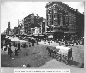
Photograph - Cable trams - Elizabeth and Collins St, 1918
Photograph shows the intersection of Elizabeth and Collins Sts Melbourne, looking North East. There are two cable trams in the view in Elizabeth St, one with a bogie trailer. There are a number of horse-drawn carts, one motor vehicle and many pedestrians crossing the streets. In the view are the GPO, a building advertising Kodak Australasia at the Block, The Windsor magazine, W E Thomas Dentist, and Dunklings. By the Dunklings store is a double decker bus with the destination of Spring St, advertising Zebra stove polish. The horse drawn covered cart is Geo Thomson Dairy Produce Merchant.Yields information about the intersection of Collins and Elizabeth St c1918Black and white print, mounted onto mauve coloured card with a printed title.tramways, cable trams, elizabeth st, collins st, buses, horse drawn vehicle -
 University of Melbourne, Burnley Campus Archives
Album - Colour prints and negatives, Kodak, Preparations for 1991 Centenary Celebrations, 1990-1991
Colour photographs taken in late Spring. Includes negatives. Also extra copies in spares.(1) Administration Building. (2) Trees. (3,4) Celebration with cake. Peter Esdale 4th from left standing, Joss Tonkin (Archivist) far right standing. (5-8) Renovating Luffmann Ponds, Paula Cave, Gardener. (9) Dairy before being renovated for Centenary, known as Landscape Shed. (10) Michael Nechwatel, Handyman clearing out Dairy prior to renovation. (11-14) Renovating Dairy.administration building, trees, celebration, cake, peter esdale, joss tonkin, archivist, renovations, luffmann ponds, paula cave, gardener, dairy, centenary, landscape shed, michael nechwatel, handyman, lily ponds -
 University of Melbourne, Burnley Campus Archives
Album - Colour prints, Stuart Miller, Garden Views, 1983
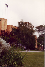
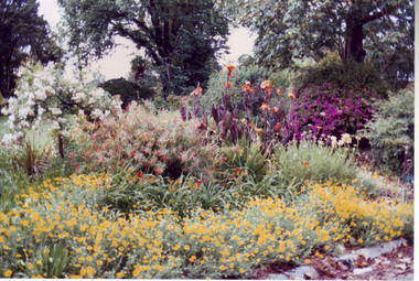
Colour photographs. (1) Herbaceous Border 1984-5 (pre-Rainforest) #277. (2) View Admin Building from between Emily Gibson Beds. (3) Admin Building. (4) View of Bull Paddock, Dairy and beyond from roof of Admin Building. (5) Rear of Burnley. Tennis Court replaced by PSL 4-6 (DA) (6) Shady Walk Mondograss (Ophiopogon japonicus) Umbrella Grass (Cyperus alternifolius) (David Aldous). (7) Admin Building and Student Amenities Building. (8-10) Luffmann Ponds. (11) Frank's/Rock Point. (12-13) Oak Lawn. (14) Oak Tree lawn on reverse "Please return to Stuart Miller, Burnley College." (15) E. cladocalyx. (16) The Victorian College of Agriculture & Horticulture-Burnley Campus. U. procera to the left E. cladocalyx to the right DA. (17) Sugar Gum E. cladocalyx Burnley Gardens 1989 DA. (18) Burnley College in background DA Crack Willow in winter. (19) Tree unidentified. DA (20) DA View of trees behind Luffmann Ponds. (21) View of Burnley Gardens Pinus canariensis to the left Agathis robusta centre and sequoia sempervirens to the right DA. (22) Students in Citriodora Courtyard. (23) View of Emily Gibson Beds from roof of Admin Building. (24) Admin Building from Oak lawn. Annotated by David Aldous and Stuart Miller. herbaceous border, administration building, emily gibson beds, bull paddock, dairy, tennis court, shady walk, luffmann ponds, oak lawn, david aldous, stuart miller, student amenities building, sugar gum, citriodora courtyard, lily ponds -
 University of Melbourne, Burnley Campus Archives
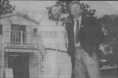
Photograph - Black and white print, Burnley Campus Archives, Centenary Centre, 1991
Appears to have been used for an exhibition Black and white photograph pasted on polystyrene board of 2 men standing in front of the former Dairy now called the Centary Centre with The Horticulture Shop on the bottom levelCaption, "With imaginative rebuilding the old dairy shed was transformed into the Centenary Centre and bookshop you see today. Peter Esdale, co-ordinator of Burnley's Centenary Committee and Brian Gibbons were photographed outside the building in 1991."dairy shed, centenary centre, bookshop, peter esdale, centenary, brian gibbons, 1991 centenary, dairy, burnley centenary committee, the horticulture shop -
University of Melbourne, Burnley Campus Archives
Photograph - Black and white prints, Burnley, c. 1948
... Dairy/Centennial Building... and white prints Dairy/Centennial Building ...Page of 14 black and white proofs of views of Burnley Campus c.1948. Mainly the removal of the Pavilion, Principal's Residence, Garden views. Not clear enough to scan.burnley gardens, pavilion, principal's residence, garden views -
 Narre Warren and District Family History Group
Booklet, Narre Warren & District Family History Group Inc, Casey Cardinia Collection - Nar Nar Goon Information File, 2005
Nar Nar Goon, a town in Gippsland, Victoria, has a rich history dating back to the mid-19th century. Originally part of the Kulin nation, the area was home to the Boon Wurrung people. The name "Nar Nar Goon" is believed to come from a Boonwurrung word referring to either the koala or the rakali. European settlement began with the establishment of the Mount Ararat pastoral run in 1844, followed by land sales in the 1850s and 1860s. Many settlers came from Ireland, particularly from the Monteagle estate in Limerick. The arrival of the railway in 1881 was a turning point, facilitating timber and agricultural industries. Several sawmills operated in the area, transporting timber via wooden tramways to the railway station. By the early 20th century, Nar Nar Goon had developed into a thriving township with a general store, hotel, butcher, baker, and garage. The town had strong Catholic roots, with a church opening in 1905. Over time, timber milling declined, and dairy farming became the dominant industry. In 2021, part of Nar Nar Goon was annexed to form the new suburb of Pakenham East. Today, Nar Nar Goon is known for its murals, historical buildings, and community spirit. It remains a small but significant town in Victoria’s history. [AI generated text]Display book containing a table of contents and various newspaper clippings and other information pertaining to the Nar Nar Goon area.non-fictionnar nar goon (vic.), nar nar goon (vic.) -- history, bernie byrne, jack egan, mark & sylvia jones, daisy lia, bill doherty, michael o'brien, joan & frank lindsay, paddy henwood, bob rose, harry james, ray coombs, jack payroll, deb bramley, nar nar goon-maryknoll cricket club, john byrne, bernie dingle, jan van steensel, len & mary bramley, kylie shanks, bill bickerton, james dore, red gem potatoes, brydie cunningham -
 Wooragee Landcare Group
Photograph, 5 September 2004
Wooragee Landcare Group took a bus trip Sunday 5th September to Samaria, Tatong area (near Benalla) to look at land use on small farms. Around this time, Wooragee Landcare were looking into how small land holders could run some enterprises. This photo was taken at Tatong Tavern where the group had lunch. The Tatong Tavern is an old English style pub situated in the foothills of the Great Dividing Range the small community of Tatong 23km south-east of Benalla. The original weatherboard hotel was originally built in the 1880s by William Worrall who was listed as Hotel Keeper from 1886 to 1910. It was destroyed by fire in 1923 and replaced by the current building, which has undergone many changes over the past 100 years. The name has also changed from the Tatong Hotel or ‘Pub’ to the current name of Tatong Tavern.Tatong is a rural village in north-east Victoria, set in undulating country that rises southwards to the Tolmie ranges. The name is thought to derive from an Aboriginal expression, possibly referring to something unseen. The Tatong pastoral run was taken up in 1847 and farm selections began in the 1870s. A school opened in 1890 (closed in 2006). Dairy herds were grazed on the Tatong flats and a cooperative creamery operated from 1892 until 1918. In 1914 a branch railway line was opened from Benalla to Tatong that carried farm produce and timber to Tatong, which had two sawmills in the 1920s. There was also a general store, a police station, and a livestock trucking yard. St Albans Church of England was built in 1921. Most of those buildings have now disappeared. The Tatong Tavern along with the Hall built in 1904 are the only remaining buildings. The Tatong Tavern is a significant tangible and visual representation of the area’s cultural and social history over the past 100 years. Coloured rectangular photograph printed on paperReverse: WAN NA E0NA2N2. NNN- 14240/ (No. 20) 373/ tatong, tatong pub, tatong tavern, tolmie ranges, tatong flats, benalla, wooragee landcare, wooragee landcare group, bus trip, samaria, land use, william worrall, 1800s, 2004, mount samaria -
 University of Melbourne, Burnley Campus Archives
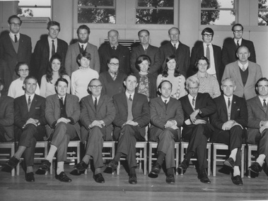
Photograph - Black and white print, Information Branch Victorian Department of Agriculture, Staff Photographs, 1967-1977
... Dairy/Centennial Building... Dairy/Centennial Building ...2 very similar photographs. Eric Littlejohn with staff (Principal 1967-1977.) "Photograph by Information Branch Victoria Department of Agriculture Ref. No. D1655C and D1655D."eric littlejohn, staff, principal