Showing 416 items
matching department of lands and survey
-
 Bacchus Marsh & District Historical Society
Map, Coimadai Parish Map, County of Bourke. Circa 1890s-1900s
... was in charge of photo-lithography at the Victorian Department of Lands...Photo-lithographed at the Department of Lands and Survey... was in charge of photo-lithography at the Victorian Department of Lands ...The cadastral Parish of Coimadai, a subdivision of the County of Bourke, lies directly north of the township of Bacchus Marsh. The date of this map is uncertain. T.F. McGauran the person who made a photo-lithographic copy of the map was in charge of photo-lithography at the Victorian Department of Lands and Survey in the late 19th century until about 1910.A single page paper map showing the map for the Parish of Coimadai in the County of Bourke. A cadastral map showing parish boundaries and land ownership. A rectangle shaped area is missing from the centre of the map due to a tear or deliberate excision. The map is pasted into a bound volume containing 76 maps or plans in total. High resolution digital image stored on BMDHS computer network. Photo-lithographed at the Department of Lands and Survey, Melbourne by T.F. McGauran 26.8.[??] NOTE. Photo litho from L.P showing temporary surveys and occupation of land prepared for departmental use onlybacchus marsh region parish plans, coimadai parish maps, coimadai parish plan -
 Bendigo Historical Society Inc.
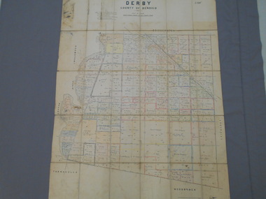
Map - JACK FLYNN COLLECTION: DERBY, 12/05/1892
... Department of Lands and Survey Melbourne by T.F.McGauran... Bendigo parish plan Derby Department of Lands and Survey Melbourne ...Map: Derby, County of Bendigo. Parish plan.Department of Lands and Survey Melbourne by T.F.McGauran, 12.5.92map, bendigo, parish plan, derby -
 Ringwood and District Historical Society
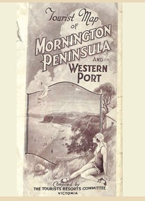
Memorabilia, Tourist Map of Mornington Peninsula and Western Port - 1929
... Photo-Lithographed by Department of Lands and Survey... Road Ringwood North melbourne Photo-Lithographed by Department ...Multi-fold pictorial map of towns, railways and main roads east of Port Phillip Bay from Melbourne to Yarra Junction and south to Phillip Island and Wonthaggi, backed by details of main features and points of interest.Photo-Lithographed by Department of Lands and Survey, Melbourne, 2.8.1929. -
 Bendigo Historical Society Inc.
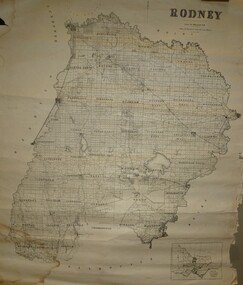
Map - JACK FLYNN COLLECTION: RODNEY, Revised in 1935
... Drawn at the Department of Lands and Survey, Melbourne... Rodney parish plan Rodney Drawn at the Department of Lands ...Map: County of Rodney, map sheet showing the whole of the County of Rodney and all of the Parishes within.Drawn at the Department of Lands and Survey, Melbourne. Revised to 1935map, rodney, parish plan, rodney -
 Ringwood and District Historical Society
Document - Map, Plan of Subdivision - Part of Crown Allotments 14A & 14C, Parish of Ringwood, County of Mornington, Vol 5378 Fol 511 - 1927
... Department of Lands and Survey photocopy dated 17/1/1951..., Vic. Department of Lands and Survey photocopy dated 17/1/1951 ...Department of Lands and Survey photocopy dated 17/1/1951, page number 12308.Map includes Canterbury Road, Heathmont Road, Dickasons Road, Bennett Avenue, Orchid Street and Allens Road, Heathmont, Vic. -
 Bendigo Historical Society Inc.
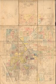
Map - JACK FLYNN COLLECTION: NEILBOROUGH, 13/10/1927
... Photo Lithographed at the Department of Lands and Survey... at the Department of Lands and Survey, Melbourne by W.J. Butson Map: Parish ...Map: Parish of Neilborough, County of Bendigo. Parish plan.Photo Lithographed at the Department of Lands and Survey, Melbourne by W.J. Butsonmap, bendigo, parish plan, neilborough -
 Bendigo Historical Society Inc.
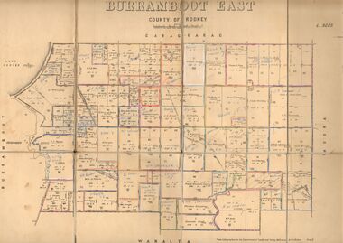
Map - JACK FLYNN COLLECTION: BURRUMBOOT EAST, 21/12/1027
... Photo Lithographed at the Department of Lands and Survey... at the Department of Lands and Survey, Melbourne by W.J.Butson. 21.12.27 Map ...Map: Burrumboot East, County of Rodney. Parish plan.Photo Lithographed at the Department of Lands and Survey, Melbourne by W.J.Butson. 21.12.27map, rodney, parish plan, burrumboot east -
 Bendigo Historical Society Inc.
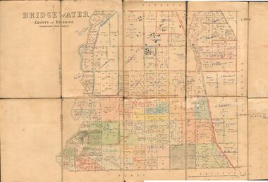
Map - JACK FLYNN COLLECTION: BRIDGEWATER, 6/10/1927
... Photo Lithographed at the Department of Lands and Survey... at the Department of Lands and Survey, Melbourne by W.J. Butson. Map ...Map: Bridgewater , County of Bendigo. Parish plan.Photo Lithographed at the Department of Lands and Survey, Melbourne by W.J. Butson.map, bendigo, parish plan, bridgewater -
 Ringwood and District Historical Society
Map, Allotments - Township of Ringwood - Parish of Ringwood - County of Mornington - 1886, 1886
... at the Department of Lands and Survey, Melbourne, 5th November, 1886.... of Ringwood area lithographed at the Department of Lands and Survey ...[Page 3, Horse Shoes to High Heels - Richard Carter] ... "(In the year 1882) the railway was extended from Hawthorn through Ringwood to Lilydale and later to Ferntree Gully." Linen-backed map of Ringwood area lithographed at the Department of Lands and Survey, Melbourne, 5th November, 1886.old lilydale road, new lilydale road, victoria brick and tile co., ringwood brick co., federal brick co. -
 Marysville & District Historical Society
Map (Item) - Tourist Map, Tourists Resorts' Committee, Tourist's Map of Healesville Marysville and Warburton Districts, 13.10.1925
... Photo Lithographed at the Department of Lands and Survey... Lithographed at the Department of Lands and Survey, Melbourne by W.J ...A tourist map for Healesville, Marysville and Warburton that was produced by the Tourists Resorts' Committee. This map was produced in 1925.A tourist map for Healesville, Marysville and Warburton that was produced by the Tourists Resorts' Committee.Photo Lithographed at the Department of Lands and Survey, Melbourne by W.J. Butson./ 13.10.25healesville, marysville, warburton, victoria, tourists resorts' committee, ben cairn, mount donna buang, the black's spur, the acheron valley, narbethong, launching place, tourist information, tourism, map, tourist map -
 Bendigo Historical Society Inc.
Map - JACK FLYNN COLLECTION: VILLAGE OF BETLEY, 30/06/1874
... Photo Lithographed at the Department of Lands and Survey... at the Department of Lands and Survey Melbourne by J. Noone 30.6.74 Map ...Map: Village of Betley, on the Bet Bet Creek, Parish of Dunolly. Parish plan.Photo Lithographed at the Department of Lands and Survey Melbourne by J. Noone 30.6.74map, gladstone, village, betley, bet bet creek, dunolly -
 Bendigo Historical Society Inc.
Map - JACK FLYNN COLLECTION: BAMAWM, 19/08/1924
... Photo Lithographed at the Department of Lands and Survey... Bendigo parish plan Bamawm Photo Lithographed at the Department ...Map: Parish of Bamawm, County of Bendigo. Parish plan.Photo Lithographed at the Department of Lands and Survey, Melbourne by W.J. Butson. 19.8.24map, bendigo, parish plan, bamawm -
 Bendigo Historical Society Inc.
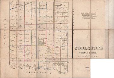
Map - JACK FLYNN COLLECTION: WOODSTOCK, 27/03/75
... Photo-Lithographed at the Department of Lands and Survey... Bendigo parish plan Woodstock Photo-Lithographed at the Department ...Map: Parish of Woodstock , County of Bendigo. Parish plan.Photo-Lithographed at the Department of Lands and Survey Melbourne by J. Noone. 27.3.79map, bendigo, parish plan, woodstock -
 Stawell Historical Society Inc
Map, Lexington County of Borong 1910, 1910
... Photo Lithographed at the Department of Lands and Survey... Lithographed at the Department of Lands and Survey. Melbourne by T.F ...Parish to the North East of MoystonA2 Parish mapPhoto Lithographed at the Department of Lands and Survey. Melbourne by T.F. McGauran 5.12.10survey -
Stawell Historical Society Inc
Map, T.F. McGauran, William Couty of Borong 1891, 1891
... Photo Lithographed at the Department of Lands and Survey... Tunnel. Water Supply Survey Photo Lithographed at the Department ...Stawell Water Supply Reserve. Grampians State Forest. Dairy Creek, Fyans Creek, Barney's Creek, Bovine Creek, Glasstree Creek, Stoney Creek. Stawell Water Supply Aquaduct Fkuming Tunnel.A2 Parish Map of Willam Inculdin Stawell Water Supply Reserve and Creeks. Marked in redPhoto Lithographed at the Department of Lands and Survey Melbourne. By T.F. McGauran 20.07.91 water supply survey -
Stawell Historical Society Inc
Map, T.F. McGauran, Winjallock County of Kara Kara, 1900
... Photo Lithographed and the department of Lands & Survey... and the department of Lands & Survey, Melbourne by T.F. McCauran 22.10.00 A2 ...Noth of Navarre and BarkleyA2 Map0f Parish of Kara Kara.Photo Lithographed and the department of Lands & Survey, Melbourne by T.F. McCauran 22.10.00survey -
 Bacchus Marsh & District Historical Society
Map, Parwan Parish Map, County of Grant, 1909
... Photo-lithographed at the Department of Lands and Survey... Parish Plan Photo-lithographed at the Department of Lands ...A single page paper map showing the map for the Parish of Parwan in the County of Grant. A cadastral map showing parish boundaries and land ownership. The map is pasted into a bound volume containing 76 maps or plans in total. High resolution digital image stored on BMDHS computer network. Photo-lithographed at the Department of Lands and Survey, Melbourne by T.F. McGauran, 7.7.09. bacchus marsh region parish plans, parwan parish maps, parwan parish plan -
 Bacchus Marsh & District Historical Society
Map, Trentham Parish Map 1905 Copy 1
... Photo-lithographed at the Department of Lands and Survey... Region Parish Plans Photo-lithographed at the Department of Lands ...A single page paper map showing the map for the Parish of Trentham in the Counties of Dalhousie and Bourke. A cadastral map showing parish boundaries and land ownership. The map is pasted into a bound volume containing 76 maps or plans in total. High resolution digital image stored on BMDHS computer network. Photo-lithographed at the Department of Lands and Survey, Melbourne by T.F. McGauran 22.3.05 trentham parish maps, trentham parish plan, bacchus marsh region parish plans -
 Bacchus Marsh & District Historical Society
Map, Blackwood Parish Map, County of Bourke, 1892
... Photo-lithographed at the Department of Lands and Survey... Blackwood Parish Maps Photo-lithographed at the Department of Lands ...A single page paper map showing the map for the Parish of Blackwood in the County of Bourke. A cadastral map showing parish boundaries and land ownership. The map is pasted into a bound volume containing 76 maps or plans in total. High resolution digital image stored on BMDHS computer network. Photo-lithographed at the Department of Lands and Survey, Melbourne by T.F. McGauran 14.7.92bacchus marsh region parish plans, blackwood parish plan, blackwood parish maps -
 Bacchus Marsh & District Historical Society
Map, Blackwood Parish Map, County of Bourke, 1905
... Photo-lithographed at the Department of Lands and Survey... Blackwood Parish Maps Photo-lithographed at the Department of Lands ...A single page paper map showing the map for the Parish of Blackwood in the County of Bourke. A cadastral map showing parish boundaries and land ownership. The map is pasted into a bound volume containing 76 maps or plans in total. High resolution digital image stored on BMDHS computer network. Photo-lithographed at the Department of Lands and Survey, Melbourne by T.F. McGauran 21.7.05bacchus marsh region parish plans, blackwood parish plan, blackwood parish maps -
 Bacchus Marsh & District Historical Society
Map, Myrniong Parish Map, County of Bourke, 1882
... Photo-lithographed at the Department of Lands and Survey... Region Parish Plans Photo-lithographed at the Department of Lands ...A single page paper map showing the map for the Parish of Myrniong in the County of Bourke. A cadastral map showing parish boundaries and land ownership. The map is pasted into a bound volume containing 76 maps or plans in total. High resolution digital image stored on BMDHS computer network. Photo-lithographed at the Department of Lands and Survey, Melbourne by J. Noone, 17.7.82myrniong parish plan, myrniong parish maps, bacchus marsh region parish plans -
 Bacchus Marsh & District Historical Society
Map, Parish of Yangardook, County of Bourke 1876
... Photo lithographed at the Department of Lands and Survey... lithographed at the Department of Lands and Survey, Melbourne by J ...The parish of Yangardook lies directly north of the township of Melton. The locality of Toolern Vale lies in the centre of this parish. A single page paper map showing the plan for the Parish of Yangardook in the in the County of Bourke. Scale 40 chains to 1 inch. The map is pasted into a bound volume containing 76 maps or plans in total. High resolution digital image stored on BMDHS computer network. Photo lithographed at the Department of Lands and Survey, Melbourne by J. Noone, 1.8.76yangardook parish maps, toolern vale victoria maps -
 Merbein District Historical Society
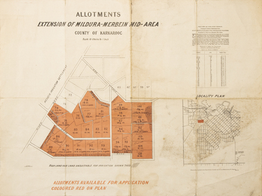
Map - Allotments Extension of Mildura-Merbein Mid-Area, Allotments available, 23 November 1920
... Photo-Lithographed at Department of lands Survey, Melbourne... Irrigation Photo-Lithographed at Department of lands Survey ...Allotments available to Discharged Soldiers Discharged Soldier's Settlement Act Historic Large map, folded in 4, coloured map of Merbein indicating allotments available and locality plan. Scale 10 chain to 1 inchPhoto-Lithographed at Department of lands Survey, Melbourne J. Butson 23.11.20discharged soldiers, ww1, soldier settlement, irrigation -
University of Melbourne, Burnley Campus Archives
Plan, Richmond Park, 1926-1954
... and hedging dated 1927. Stamp, Department of Lands and Survey 8.9.54..., Department of Lands and Survey 8.9.54 (Original plan dated 25.3.27 ...Photocopy of Section of a Survey Plan 1926 showing fencing and hedging dated 1927. Stamp, Department of Lands and Survey 8.9.54 (Original plan dated 25.3.27) Part of handwritten notes signed "M. Anderson ? 28/2/45."parks, richmond, burnley gardens, orchards -
 Bendigo Historical Society Inc.
Map - JACK FLYNN COLLECTION: TARNAGULLA SHEET 4, 25/11/1926
... Photo-Lithographed at the Department of lands and Survey... at the Department of lands and Survey, Melbourne by W. J. Butson. 25.11.26 ...Map: Parish of Tarnagulla Sheet 4, Counties of Gladstone and Bendigo. Parish plan.Photo-Lithographed at the Department of lands and Survey, Melbourne by W. J. Butson. 25.11.26map, gladstone, parish plan, tarnagulla sheet 4 -
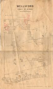 Bendigo Historical Society Inc.
Map - JACK FLYNN COLLECTION: WELLSFORD, 2/11/1914
... Photo-Lithographed at the Department of Lands and Survey... Bendigo parish plan Wellsford Photo-Lithographed at the Department ...Map: Parish of Wellsford, County of Bendigo. Parish plan.Photo-Lithographed at the Department of Lands and Survey Melbourne By H.J. Butson. 2-.11.14map, bendigo, parish plan, wellsford -
 Bacchus Marsh & District Historical Society
Map, Mooradoranook Parish Map, County of Grant
... Photo lithographed at the Department of Lands and Survey... Marsh Region Parish Plans Photo lithographed at the Department ...A single page paper map showing the map for the Parish of Mooradanook in the County of Grant. Cadastral map showing land ownership. The map is pasted into a bound volume containing 76 maps or plans in total. High resolution digital image stored on BMDHS computer network. Photo lithographed at the Department of Lands and Survey Melbourne by T. F. McGauran, 27.11.06mooradoranook parish maps, mooradoranook parish plan, bacchus marsh region parish plans -
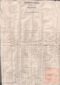 Bendigo Historical Society Inc.
Map - MAP. WARRAGAMBA. COUNTY OF BENDIGO, 1915
... . Diggorra. Kamarooka Photographedat the Department of LANDS.... Kamarooka Photographedat the Department of LANDS AND Survey ...Map. Warragamba. Colunty of Bendigo. Pannoomilloo. Minto. Diggorra. Kamarooka Photographedat the Department of LANDS AND Survey Melbourne by W. J. Butson. -
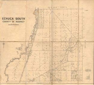 Bendigo Historical Society Inc.
Map - JACK FLYNN COLLECTION: ECHUCA SOUTH, 13/08/1931
... By Authority H. J. Green, Govt. Printer. Department.... J. Green, Govt. Printer. Department of Lands and Survey ...Map: Parish of Echuca South, County of Rodney. Parish plan.By Authority H. J. Green, Govt. Printer. Department of Lands and Survey, Melbourne. 13.8.31map, rodney, parish plan, echuca south , county of rodney