Showing 105 items matching "diamond creek - maps"
-
 Eltham District Historical Society Inc
Scrapbook Album, The Colour and Texture of Eltham, 1997, 1997
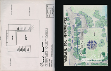
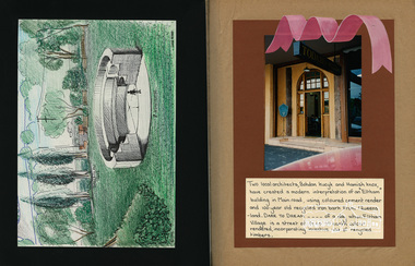
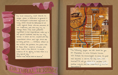
... heritage map david armfield diamond creek diamnond valley news ...Put together by a member of the Eltham Community Action Group in participation with various artists, writers, local business people and other local citizens and sent to Minister Maclellan, Planning Minister in the Kennet Government in protest of proposed plans to sell the former Eltham Shire Office site at 895 Main Road Eltham in order to develop a Shell Service Station and Hungry Jacks fast food outlet. The purpose was to express what is unique about the character of Eltham, why people live and work there and why such a development would be out of character and inappropriate for the Eltham Gateway along with alternative development proposals. This protest was the catalyst for the formation of the Eltham Community Action Group.Scrapbook album approx 40 x 30 x 4 cm, black hardcovers and 36 double page openings, numerous blank pages.alan marshall, alistair knox park, alistair knox, alternative proposals, ampitheatre, artists, betty langley, bohdan kucyk, bootmakers cottage, bridge street, cultural heritage map, david armfield, diamond creek, diamnond valley news, eltham art house theatres, eltham community action group, eltham library, eltham traders, eltham, flavour of eltham, george stebbing, gordon ford, hamish knox, helen lucas, hungry jacks, janet r boddy, jarrold cottage, jarrold family, john pizzey, jon weaving, lena skipper, letters, local business register, 895 main road, main road, eltham shire office, matcham skipper, ming mackay, minister maclellan, montsalvat, mudbrick, newspaper clippings, peter dougherty, peter glass, pioneers and painters, railway line, shell service station, shelltham, protests, shillinglaw cottage, shire of eltham, nillumbik shire, st margaret's anglican church, todaro, trestle bridge, wingrove cottage, charles symons wingrove -
 Eltham District Historical Society Inc
Scrapbook Album, The Colour and Texture of Eltham, 1997, 1997
... heritage map david armfield diamond creek diamnond valley news ...Put together by a member of the Eltham Community Action Group in participation with various artists, writers, local business people and other local citizens and sent to Minister Maclellan, Planning Minister in the Kennet Government in protest of proposed plans to sell the former Eltham Shire Office site at 895 Main Road Eltham in order to develop a Shell Service Station and Hungry Jacks fast food outlet. The purpose was to express what is unique about the character of Eltham, why people live and work there and why such a development would be out of character and inappropriate for the Eltham Gateway along with alternative development proposals. This protest was the catalyst for the formation of the Eltham Community Action Group.Scrapbook album approx 40 x 30 x 4 cm, black hardcovers and 36 double page openings, numerous blank pages.alan marshall, alistair knox park, alistair knox, alternative proposals, ampitheatre, artists, betty langley, bohdan kucyk, bootmakers cottage, bridge street, cultural heritage map, david armfield, diamond creek, diamnond valley news, eltham art house theatres, eltham community action group, eltham library, eltham traders, eltham, flavour of eltham, george stebbing, gordon ford, hamish knox, helen lucas, hungry jacks, janet r boddy, jarrold cottage, jarrold family, john pizzey, jon weaving, lena skipper, letters, local business register, 895 main road, main road, eltham shire office, matcham skipper, ming mackay, minister maclellan, montsalvat, mudbrick, newspaper clippings, peter dougherty, peter glass, pioneers and painters, railway line, shell service station, shelltham, protests, shillinglaw cottage, shire of eltham, nillumbik shire, st margaret's anglican church, todaro, trestle bridge, wingrove cottage, charles symons wingrove -
 Federation University Historical Collection
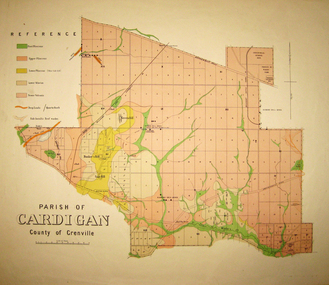
Map - Geological survey, Parish of Cardigan, County of Grenville, c1889
Geological map of the Parish of Cardigan on a cadastral base showing quartz reefs, shafts, alluvial deposits.cardigan, winter's creek, ballarat cattle yards railway, prince of wales park, ballarat, friendly societies reserve, ballarat industrial school reserve, green hill, bunker's hill, sago hill, diamond drill bores, cardigan propriety, half way house, ti tree creek, albion consols, prince imperial, winter's freehold company -
 Nillumbik Historical Society Incorporated
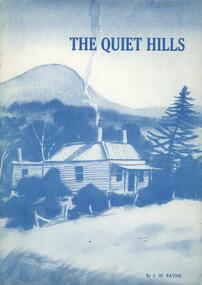
Book - Softcover book, Doreen Primary School, The Quiet Hills, 1983
A history in recollections and photographs of the Doreen district of Victoria, AustraliaCover is card 300gsm with painting converted to blue tones on front and back with white semi gloss paper pages 100gsm - 37 pages plus 3 page index and maps on inside of front and back coversnon-fictionA history in recollections and photographs of the Doreen district of Victoria, Australia -
 Nillumbik Historical Society Incorporated
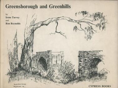
Book - Hardcover book, Cypress Books, Greensborough and Greenhills, 1983
A history in recollections and photographs of the Doreen district of Victoria, AustraliaHardcover with linen finish and colour and no dust cover, paper pages 100gsm - 62 pages with etchings and a mapnon-fictionA history in recollections and photographs of the Doreen district of Victoria, Australia -
 Whitehorse Historical Society Inc.
Map, Environment effects statement, 1/03/1979 12:00:00 AM
Diamond Creek-Ringwood study: Planning Scheme reservations and zones with recommended concept.Diamond Creek-Ringwood study: Planning Scheme reservations and zones with recommended concept. City of Nunawading: section north of Canterbury Road. Scale 1:25,000 metric. Map B with drafting ref. no. 145Diamond Creek-Ringwood study: Planning Scheme reservations and zones with recommended concept. city of nunawading, land use, melbourne metropolitan planning scheme -
 Kew Historical Society Inc
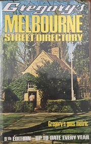
Book, Gregory's Publishing Company Pty Ltd, Gregory's Street Directory of Melbourne and suburbs and Metropolitan Road Guide, 1971
Street DirectoryRevised edition of Gregory's Directory including a series of road maps of Melbourne and its suburbs, newly extending to Lilydale, Mornington, Laverton, Deer Park, Epping, Diamond Creek, Olinda, Belgrave, and Doveton.non-fictionStreet Directorystreet directories - melbourne, gregory's street directories -
 Eltham District Historical Society Inc
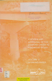
Book, A Review and Appraisal of the Diamond Creek to Ringwood Study, volume 2, working paper, by Loder and Bayly, 1979
Volume 2: Working papers. This report is a review and appraisal of the Outer Ring Road Study Diamond Creek to Ringwood prepared for The Road Planning Liaison Committee by the Joint Road Planning Group for the The City of Doncaster & Templestowe and The Shire of Eltham by Loder & Bayly Planning & Engineering Consultants. "This paper attempts to set a framework for an evaluation of the recommended road link between Diamond Creek and Ringwood." Various perspectives are examined. Includes fold out maps.91 p, maps, 27 cm.melbourne ring road, roads, freeways -
 Greensborough Historical Society
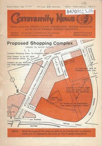
Newsletter, Greenhills and North Greensborough Progress Association, Community News: official journal of the Greenhills and Nth. Greensborough Progress Association and the Apollo Parkways Progress Association.10th February, 1977. Edition No. 1/77, 10/02/1977
Proposed shopping complex - Public meeting, Super shops, Letters to the Editor, From the Council Chamber, Freedom from despair, Grow, Co-operative education in Diamond Creek, This and that,. Supplement to "Community News". No. 1/77. Geoff Kerry has a... Community News "family chat". A digital copy of this Newsletter is available from Greensborough Historical Society. Newsletter, 20 p., illus., map.greenhills and north greensborough progress association, greenhills, apollo parkways progress association, apollo parkways -
 Greensborough Historical Society
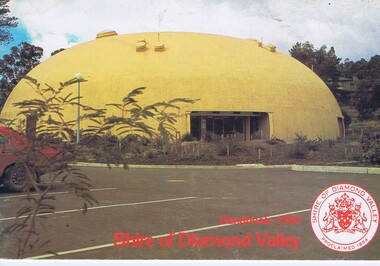
Booklet, The Shire of Diamond Valley Handbook 1981, 1981_
Guide to services provided by Shire of Diamond Valley. The Shire of Diamond Valley was a Local Government Area located about 20 kilometres northeast of Melbourne. The shire covered an area of 74.38 square kilometres and existed from 1964 until 1994. Cover illustration of "Diamond Creek Bini-shell".Annual guide to services in Shire of Diamond Valley28 pages, col illus., maps. (3 copies)shire of diamond valley, greensborough, handbooks -
 Greensborough Historical Society
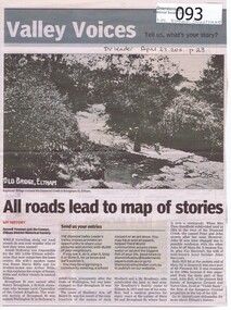
Newspaper - Newspaper clipping, All roads lead to map of stories, 27/04/2011
Family history of Josiah Holloway, origins of street names in the subdivision of Eltham History of Eltham and origins of street names connected with pioneers of the area.Newsprint, gray scale. Photograph of Keylock's Bridge on Diamond Creek at ElthamDV Leader April27 2011, p23josiah holloway, jack shallard, susanna maria bible, bradbury, henry brougham, handfield, fay harcourt, violet bank, kangaroo ground, bells hillroad, shalbury avenue, beard street, brougham street, main road, eltham -
 Eltham District Historical Society Inc
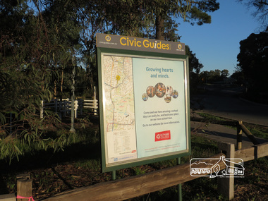
Photograph, Liz Pidgeon, Heritage Excursion; Eltham Lower Park, 1 July 2017
Civic Guide sign near the entrance of Eltham Lower Park with a map of the local area and an advertisement for Eltham College Newsletter No., 234, June 2017 Heritage Excursion - Saturday 1st July - Eltham Lower Park - Walk and Talk Eltham Lower Park has played an important part in the history of our area since the early days of European settlement when it was used by local residents as an informal racecourse. Prior to that its location at the junction of the Diamond Creek and the Yarra River made it an important meeting place for the Wurundjeri people. The park combines formal elements and sporting facilities with remnant bushland that is of environmental significance. It is home to sporting and horse riding clubs, popular play spaces and the Diamond Valley Miniature Railway, which attracts large numbers of visitors. The park will be the venue for our July excursion which will comprise a walk of about 3.5 km around the park and adjacent areas. Along the way we will discuss the history and natural history of the area. The path along the creek and the river provides a pleasant and scenic walk. This walk on Saturday 1st July is about 3.5 km in length and will take 2 to 2.5 hours. It will start at 2pm at the Main Road car park at the front of the park. (Melway ref 21 H 10). This sign was removed in about 2021 when works began on the building of an intersection to replace the roundabout at Fitzsimons Lane & Main Road. By May 2023 plantings in green spaces near Eltham Lower Park took place before the official opening of the new Eltham Gateway.Born Digitalheritage excursion, activities, eltham district historical society, eltham lower park, civic guide, eltham college, sign -
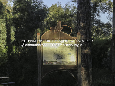 Eltham District Historical Society Inc
Photograph, Liz Pidgeon, Heritage Excursion; Eltham Lower Park, 1 July 2017
Sign at the front of the park which includes a map. Newsletter No., 234, June 2017: Heritage Excursion - Saturday 1st July - Eltham Lower Park - Walk and Talk Eltham Lower Park has played an important part in the history of our area since the early days of European settlement when it was used by local residents as an informal racecourse. Prior to that its location at the junction of the Diamond Creek and the Yarra River made it an important meeting place for the Wurundjeri people. The park combines formal elements and sporting facilities with remnant bushland that is of environmental significance. It is home to sporting and horse riding clubs, popular play spaces and the Diamond Valley Miniature Railway, which attracts large numbers of visitors. The park will be the venue for our July excursion which will comprise a walk of about 3.5 km around the park and adjacent areas. Along the way we will discuss the history and natural history of the area. The path along the creek and the river provides a pleasant and scenic walk. This walk on Saturday 1st July is about 3.5 km in length and will take 2 to 2.5 hours. It will start at 2pm at the Main Road car park at the front of the park. (Melway ref 21 H 10). This sign was removed in about 2021 when works began on the building of an intersection to replace the roundabout at Fitzsimons Lane & Main Road. By May 2023 plantings in green spaces near Eltham Lower Park took place before the official opening of the new Eltham Gateway. The sig Born Digitalelection day, heritage excursion, activities, eltham district historical society, eltham lower park, sign