Showing 192 items matching "district surveyor"
-
 Eltham District Historical Society Inc
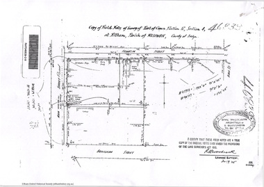
Document - Photocopy, Survey Fleld Notes of Part of Crown Portion 12, Section 4 at Eltham, Parish of Nillumbik, County of Evelyn, 30 September 1925
Portion of land bounded by: Main Road, Franklin Street, Bible Street, Brougham Street Application 46839 R. Woodcock, Licensed Surveyor, 30 September 1925application 46839, bible street, brougham street, eltham, franklin street, main road, map, survey plan -
 Eltham District Historical Society Inc
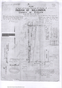
Survey Fleld Notes of Part of Crown Portion 13, Section 4 at Eltham, Parish of Nillumbik, County of Evelyn, 17 May 1926
Portion of land bounded by: Eltham Railway Station, Main Road, Luck Street, Arthur Street Application 4182/215 J.T. Robinson, Licensed Surveyor, 17 May 1926application 4182/215, arthur street, eltham, eltham railway station, luck street, main road, map, survey plan -
 Eltham District Historical Society Inc
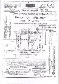
Document - Photocopy, Survey Fleld Notes of Part of Crown Portion 12, Section 4 at Eltham, Parish of Nillumbik, County of Evelyn, 18 March 1926
Portion of land bounded by: Main Road, York Street, Bible Street, Bridge Street Application 46906 R.H. Woodcock, Licensed Surveyor, 18 March 1926application 46906, bible street, bridge street, eltham, main road, map, survey plan, york street -
 Eltham District Historical Society Inc
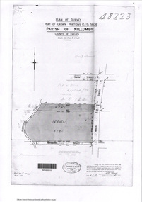
Document - Photocopy, Survey Fleld Notes of Part of Crown Portions 12 & 13, Section 4 at Eltham, Parish of Nillumbik, County of Evelyn, 6 May 1929
Portion of land bounded by: Main Road, York Street, Diamond Creek, Swan Street Application 48223 P.N. Guy, Licensed Surveyor, 6 May 1929application 48223, diamond creek (creek), eltham, main road, map, survey plan, swan street, york street -
 Eltham District Historical Society Inc
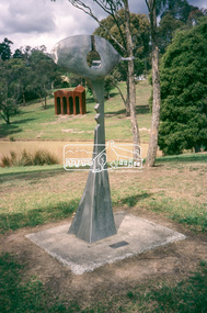
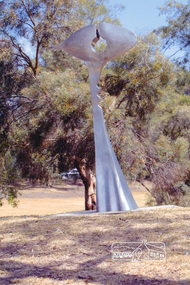
Slide - Photograph, Sculpture, Surveyor of Suburban Environs, Ernst Fries (1991), Alistair Knox Park, cnr Bridge Street and Main Road, Eltham, c.1993
35mm colour positive transparency Mount - Black and Whitealistair knox park, art in public places, classical-landscape (1996), cliff burtt, public art, sculptures, surveyor of suburban environs (1991) -
 Eltham District Historical Society Inc
Slide - Photograph, Surveyor of Suburban Environs, Ernst Fries (1991), Alistair Knox Park, Eltham, c.Nov. 2001
Part of a slide show presentation "A Trip Down the Diamond Creek" by Russell Yeoman to the Eltham District Historical Society meeting of 14 Nov. 200135mm colour positive transparency Mount - Black and Whiteeltham, alistair knox park, art in public places, ernst fries, public art, surveyor of suburban environs (1991) -
 Marysville & District Historical Society
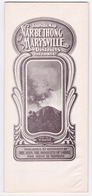
Map (Item) - Tourist Map, Department of Lands & Survey, Tourist's Map of Narbethong and Marysville Districts Victoria, 1913
A tourist map for the Narbethong and Marysville Districts that was originally produced by the Department of Lands & Survey in 1925.A tourist map for the Narbethong and Marysville Districts that was originally produced by the Department of Lands & Survey in 1925.Reprint of the 1925 Tourist brochure by permission R.E. Holmes Surveyor General By Authority: ALBERT J. MULLETT, Government Printer, Melbourne. Photo Lithographed at the Department of Lands and Survey Melbourne by W.J. Butson/ 26.8.13narbethong, marysville, victoria, department of lands & survey, the acheron valley, warburton, map, tourist map -
 Phillip Island and District Historical Society Inc.
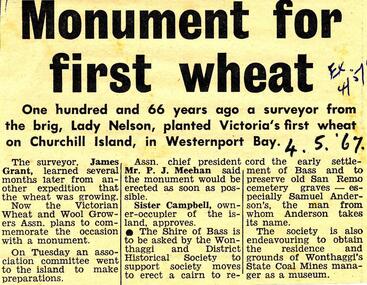
Newspaper Clipping, First Wheat planted in Victoria, 4/5/1967
Collection of newspaper clippings from Scrap Book 1960 - 1973Article about the first wheat planted in Victoria on Churchill Island by surveyor James Grant 166 years ago and a Monument should be erected to commemorate the occassion.first wheat crops for victoria, churchill island, james grant, newspaper clipping, jean jamieson -
 Glenelg Shire Council Cultural Collection
Certificate - Certificate - Historic Buildings, Portland Town Hall, 1974
From the Victorian Heritage Register: The foundation stone of the original Portland Town Hall was laid by William Learmonth on 21st September, 1863 following a competition and subsequent public controversy over the permitted entry of architect John Barrow. The conservative classical design of municipal surveyor Alexander Ross was preferred and this axially planned design with central council chamber and side offices fronted by a fine axed pedimented gable entablature of basalt and Tuscan Doric pilasters was completed by 24th may 1864. The old Town Hall is one of a distinguished group of public buildings in Portland and an interesting example of conservative classical architecture of the first years of settlement in western Victoria. The basalt structure was partially erected of stone from the Portland stockade and has significant historical associations with local Government administration in the district. The Town Hall is the most impressive work of Alexander Ross, a surveyor architect whose career remains largely undocumented. The old Town Hall at Portland has been discreetly extended at the rear to provide additional meeting room accommodation. The premises are no longer used for local government administration.A4 sized certificate demonstrating Portland Town Hall's special significance to the state of Victoria & inclusion on the Historic Building Register. Singed by Robert Maclellan, Minister for planning & Historic Buildings Council Chairperson. Red seal attached, bottom right.portland town hall, history house, heritage register, historic buildings, certificate -
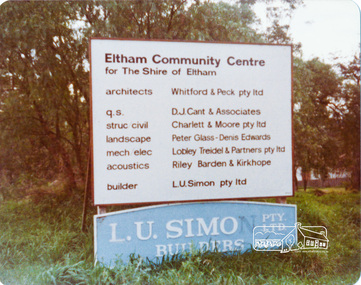 Eltham District Historical Society Inc
Photograph, Peter Bassett-Smith, Construction of Eltham Community Centre, June 1977, 1977
Building construction sign - Architects: Whitford & Peck Pty Ltd; Quantity Surveyor: D.J. Cant & Associates; Structural Civil Engineers: Charlett & Moore Pty Ltd; Landscape: Peter Glass, Dennis Edwards; Mech Elec: Lobley Treidel & Partners Pty Ltd; Acoustics: Riley Barden & Kirkhope; Builder: L.U. Simon Pty Ltdeltham, eltham community centre, buildings, construction -
 Eltham District Historical Society Inc
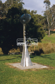
Photograph, Surveyor of Suburban Environs, Ernst Fries (1991), Alistair Knox Park, Eltham, March 2004, 2004
Colour photographeltham, alistair knox park, art, sculptures, ernst fries, surveyor of suburban environs (1991) -
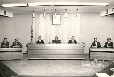 Eltham District Historical Society Inc
Photograph, Shire of Eltham Senior Staff, 1971, 1971
Formal photograph of Shire of Eltham Senior Staff, in Shire of Eltham (Main road Eltham, now demolished). From left: George Newton (Building Surveyor), Martin Verhoevan (Deputy Shire Engineer), John McDonald (Shire Engineer), Geoff Dreverman (Shire President), Max Watson (Shire Secreatary), Tony Roberts(?) (Deputy Shire Secretary) and Barry Gaudin (Chief Health Surveyor)Black and white print 25.5 cm x 20.5 cmA2206 Hugh Fisher 82 Lygon St, Brunswick 3057 38-3040 6 York St, Eltham 3095 439-9046 councilors, shire of eltham, george newton, martin verhoevan, john mcdonald, geoffrey dreverman, max watson, tony roberts, barry gaudin -
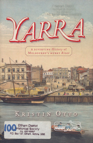 Eltham District Historical Society Inc
Book, Kristin Otto, Yarra : a diverting history of Melbourne's murky river / Kristin Otto, 2005
"It was John Wedge, Batman's private surveyor, who named the Yarra Yarra. In September 1835 he was at the Turning Basin with some Kulin and heard them identify the river as it came over the Falls as, he wrote, 'Yarrow Yarrow'. It was only some months later that Wedge discovered they had been referring to the pattern and movement of water over the Falls, not the river itself. And ever since, it has been the Yarra's fate to be misunderstood: maligned for its muddiness, ill-used as sewer and tip; scooped, sculpted, straightened and stressed, 'cleaned up' to the detriment of its natural inhabitants; built-over, under and beside; worked mercilessly and then bridged almost to maritime extinction. In Kristin Otto's superbly entertaining new history, the whole sorry tale is laid bare. From the creation stories of Kulin owners and geologist blow-ins (and Robert Hoddle's bad-tempered expedition to the headwaters) to the twenty-first-century waterside building boom, Otto traces the course of Melbourne's murky river. Erudite, affectionate and witty, with more meanders and diversions than the river itself, Yarra is both a fascinating read and a fitting tribute to the 'noble stream'." -- Publisher's website.Paperback; [viii], 245 p. : illus., maps ; 24 cm.ISBN 1920885781yarra river -
 Eltham District Historical Society Inc
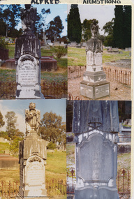
Folder, Armstrong
Alfred Armstrong Armstrong, Alfred, Eltham is a native of Somerset, England, born in 1825, and was employed under Mr. Mark Isambard Kingdom Brunel as a civil engineer prior to his coming out to Melbourne in 1852. He first visited Beechworth, but returning to Melbourne took contacts at Essendon and Gisbourne for forming and metalling the road. He afterwards purchased property at Eltham, where is at present mining, surveyor, inspector of mines, and mining registrar for the St Andrew’s division of the Castlemaine mining district. Mrs Armstrong, to whom he was married in 1854, at St Paul’s Church, Melbourne, died on 27th March, 1887. from "Victoria and its Metropolis: Past and Present" written in 1888 by Alexander Sutherland. Chapter 19, "The Upper Yarra District" pages [402] - 415. Includes descriptions of some townships and short biographies of local residents. Page 405 Folder of information on Alfred Armstrong, Eltham and Kangaroo Groundalfred armstrong, ada gertrude armstrong, arthur reynolds stockwood armstrong, arthur vivian harrison, eltham cemetery, gravestones, laura augusta harrison (nee armstrong), margaret armstrong, mary armstrong, thomas armstrong -
Eltham District Historical Society Inc
Folder, R. Brazill, 1860s
Folder of information on R Brazill, mining surveyor, Caledonia Diggings, 1860sr brazill -
 Warrnambool and District Historical Society Inc.
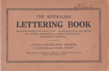
Booklet - Lettering Book, Halstead Press Pty Ltd, The Australian Lettering Book, 1945
Author Herbert Newell. Alphabets of varied fonts, headings, flourishes, plans, numerals, sketch maps, scrolls, shading, common errors, compass points. Especially designed for use in Australian Schools, offices of Lawyers, Architects, Surveyors, Engineers, Engravers, and Draughtsmen. Table of contentsThe author is a teacher of show card and ticket writing at Sydney Technical College. Book used by many students and offices. Note by the publishers provides standards for the correct form of the characters. Light brown light card cover with black ink font and border patterns. 32 Cream pages with black ink. Two staples. Hand written name on top of outline black border S. R Coleston. Price 3/9warrnambool, lettering book, angus & robertson limited, s.r. coleston, herbert newell -
 Eltham District Historical Society Inc
Negative - Photograph, Warrandyte Bridge over River Yarra, c.1910
View of the 1875 timber trestle bridge over the Yarra River reproduced from a newsprint image. Also known as Anderson's Creek (Road) Bridge A contract was accepted for William Elliot to erect a bridge over the Yarra River at Warrandyte on Anderson's Creek Road and other improvements for £1,331.6.2 - Gazette No. 143. Tuesday, November 13th 1860 - http://gazette.slv.vic.gov.au/view.cgi?year=1860&class=general&page_num=2161&state=V&classNum=G143&id=). The bridge was washed away by floods in 1863. It was replaced with a taller timber trestle structure in October 1875, designed and built by C.S. Wingrove, Shire Clerk, Engineer and Surveyor for Eltham Shire Council. A replacement for this bridge was commenced in 1955 to cope with increasing traffic and this structure was widened in 2018 to meet further traffic demands. Argus (Melbourne, Vic. : 1848 - 1957), Thursday 23 September 1875, page 7 ________________________________________ THE WARRANDYTE BRIDGE. The ceremony of formally opening the newly erected bridge over the Yarra at Ander-son's Creek was performed on Monday last, in the presence of the members of the Eltham and Bulleen shire councils whose territories it joins, and a goodly number of the residents of the district. The task was delegated to Mr. Cameron, M.L.A., who, after a few introductory remarks declared the bridge to be opened, and christened it the " Warrandyte Bridge." The party then adjourned to Grant's Hotel, where a cold collation had been prepared. The chair was taken by the president of the Eltham shire (Mr. John Bell) and the vice chair by Mr. Kent, a member of the Bulleen council. Mr Robert Williamson proposed "Success to the bridge," coupling with it the name of Mr. Cameron, to whose exertions was in the main to be attributed the erection of that structure which was an ornament to the district and would prove of great service to both sides of the river. Mr. Cameron, in responding, alluded to the great difficulties, mainly of a pecuniary nature, that had been encountered in carrying out the project, and which had only been got over by their united efforts and by the liberal spirit in which the late Commissioner of Roads had dealt with the case. The healths of the contractor and the engineer were also drunk. The bridge is a trussed timber one, resting on yellow box piles sunk into the solid rock, each pier being weighted with 50 tons of stone. The abutments consist of dry stone walls, 6ft. thick at the base, and tapering to 3ft. on the top, the face of the work having a batter of 1 to 1. The length of the bridge is 308ft., there being four openings in the centre of 66ft. each, and two at the ends of 20ft. each. The width in the clear is 9½ft., and the height from the bed of the river about 33ft. The approaches comprise 1,100 cubic yards of earthwork, and the formation of 48 chains of sideling, the whole cost of the work, which was carried out under the direction of the engineer to the Eltham Shire Council, being £1,413.This photo forms part of a collection of photographs gathered by the Shire of Eltham for their centenary project book,"Pioneers and Painters: 100 years of the Shire of Eltham" by Alan Marshall (1971). The collection of over 500 images is held in partnership between Eltham District Historical Society and Yarra Plenty Regional Library (Eltham Library) and is now formally known as the 'The Shire of Eltham Pioneers Photograph Collection.' It is significant in being the first community sourced collection representing the places and people of the Shire's first one hundred years.Digital image 4 x 5 inch B&W Neg B&W Print 12.5 x 9 cmsepp, shire of eltham pioneers photograph collection, warrandyte, bridge -
 Orbost & District Historical Society
book, Effingham, Wilson, A Geographical Dictionary of the Australian Colonies, 1848
A geographical dictionary or gazetteer of the Australian colonies : their physical and political geography : together with a brief notice of all the capitals, principal towns, and villages. William Wells travelled to Australia as a sponsored immigrant in 1838. Her became a freelance surveyor with an office in Bligh Street, Sydney. He wrote this book in order to better inform the British public on the colonies of Australia. The information contained in the book is both topographical and statistical and was a very useful refernece book at the time.This book is a rare detailed contemporary record of the Australian colonies in the mid 19th century.A hard back 453 pp book with a dark brown patterned cover which has a white label with the title, "Dictionary of Geography" over a map of Australia. It is illustrated with numerous maps and drawings.history-australia wells-william-henry geographical-dictionary-of-the-australian-colonies -
 Orbost & District Historical Society
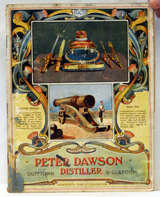
magazines, Banks & Company, Peter Dawson Distiller, 1907
This is the 14th edition of the magazine. This magazine belonged to William Hunter (1893-1971), a resident of Tatura and Mallacoota. He was a soldier, surveyor and amateur naturalist. Peter Dawson was a Distiller and Whisky Merchantat 99 Maxwell Street, Glasgow. By 1891 Dawson had already made a name for himself in the United Kingdom as a blender of whisky and practical distiller. This item is associated with William Hunter.A magazine / catalogue with a cover showing coloured illustrations of military weapons and ordinance. At the bottom is "Peter Dawson Distiller Dufftown & Glasgow" in red and black print inside an ornate gold frame."William Hunter"hunter-william dawson-peter-distiller magazine-weapons-ordinance -
 Orbost & District Historical Society
book, August 1919
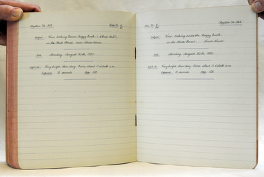
These record were made by William Hunter. William Hunter (1893-1971), resident of Tatura and Mallacoota, was a soldier, surveyor and amateur naturalist.This item is associated with William Hunter.Two lined page book with back covers glued together. They contain hand-written astronomical observations and records of photographs taken. There is a blotter inside.hunter-william astronomy -
 Orbost & District Historical Society
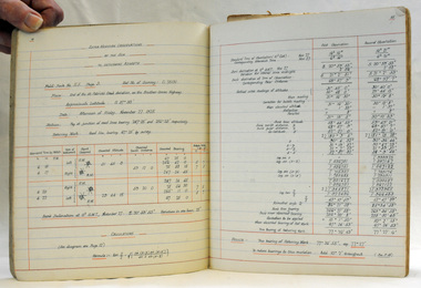
book, 1922
William Hunter (1893-1971), resident of Tatura and Mallacoota was a soldier, surveyor and amateur naturalist.This item is associated with William Hunter.A black covered book of astronomical observations and results handwritten on lined pages. Inside is a blotter - "Reed Bros Tomato Sauce" ; an envelope addressed to "William Hunter Esquire Survey Camp Tubbut" and three stamps.hunter-william astronomy science -
Ringwood and District Historical Society
Envelope, Packet: Paper on Clement Hodgkinson, Nunawading Surveyor
Paper delivered to Nunawading Historical Society August 1967 on Clement Hodgkinson, Surveyor of Nunawading; Letter to Ellie Pullin -
Ringwood and District Historical Society
Envelope, Packet: Hull (Surveyor) - Letter 1854
4-page letter (copy) to Surveyor General from Mr Hull 1854 -
 Orbost & District Historical Society
black / white photograph, 1897
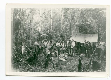
Link with item 1178. This is a surveyors' camp in the McCulloch Ranges, Murrangowar, April, 1897. Included in the photograph are: L. Thorn; Pearson; L. Coburn, Clem Bates; Sam Blacklock with a packhorse. They were surveying for a road or railway. Surveyors were among the first European settlers to arrive in Australia. A Surveyor-General was present on the First Fleet, as well as the first two ships which landed in South Australia. These men were issued with instructions to record observations in a journal that included the country’s general appearance, its soil, flora and fauna and the customs and language of local inhabitants. The conditions they worked in were harsh and they embarked on journeys with drays carrying cumbersome surveying and camping equipment, spending months camping out in the bush and mapping the land. It was not until well into the second half of the nineteenth century that the professional training of surveyors became mandatory in Australia.This is a pictorial record of a surveyors' camp in the late 19th century.A black / white photograph of a group of men standing in front of a tent / camp in a dense bush setting.surveyor's-camp-mccullochs-ranges-murrangowar land-settlement -
 Ringwood and District Historical Society
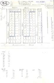
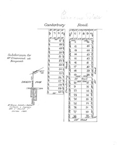
Plan, Plan of Subdivision No.11498 with handwritten costing notations - East Ringwood Central Estate c.1948
Two handwritten pages showing layout of Subdivision no 11498 with surveyor notations including property sizes and road construction cost calculations. Drainage easement 6 feet wide shaded blue.Plan of Subdivision No. 11498, Part of Crown Allotment 27, Parish of Ringwood, County of Mornington, (Certificate of Title Vol 5120 Fol 1023945). Owner Mr Vogel. Subdivision includes Knaith Road, Northwood Street, Langley Street, Bondi Street, and Government Road (later Alexandra Road), Ringwood East. G. Parsons & Sons, Licensed Surveyors, 389 Flinders Lane (Melbourne). -
 Ringwood and District Historical Society
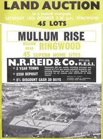
Flyer, Land Auction Advertisement, Mullum Rise, Ringwood - 1970
Double sided leaflet with aerial view of part of Ringwood showing subdivision site, terms of sale, layout of streets and allotments, and summary of local features and services.Land auction, Saturday, 10th October (1970). 45 home sites. Subdivision includes Mullum Mullum Road, Hugh Street, Rollington Drive, Cassandra Court, and Jeffrey Drive. Surveyors - R.G. Lee Pty. Ltd., 6 Davis Street, Richmond. Agents - N.R. Reid & Co., 173 Coleman Parade, Glen Waverley, (Telephone) 560 0355 A.H. 560 0361 and Safeway Centre, Boronia Road, Boronia, (Telephone) 762 1022 A.G. 795 2887, also at East Malvern and Mount Waverley. -
 Ringwood and District Historical Society
Plan, Paradise Estate Subdivision, Ringwood, Victoria - circa 1925
Paradise Estate layout also included in Land Sale Brochure Titled Eureka Plan Book - Seven Delightful & Valuable Ringwood Estates - circa 1925, Reg. No. 5100.Subdivision plan of Paradise Estate, Ringwood, showing allotments for sale, with typed page attached showing block sizes and prices.Locality plan showing land for sale south of Canterbury Road, 1 Mile south of Ringwood Railway Station. Subdivison includes Canterbury Road and Dandenong Road (later Wantirna Road). Surveyors - McKenzie Aisbett & Webber, surveyors & engineers, 440 Little Collins Street, Melbourne, Telephone Central 11540. Subdivision for Mr Grenwood at Ringwood. Additional typewritten price list showing footage, price per foot, and price per block for Lots No. 1 to 60. Paradise Estate layout also included in Land Sale Brochure Titled Eureka Plan Book - Seven Delightful & Valuable Ringwood Estates - circa 1925, Reg. No. 5100. -
 Ringwood and District Historical Society
Pamphlet, G.A. Green, Auction Sale Brochure - Garden Farms Estate, Ringwood, Victoria - 1919, 1919
Multi-fold brochure advertising public auction of one-acre, 2-acre, 5-acre and 8-acre allotments in Ringwood and Bayswater on Saturday 12th April, 1919. Brochure includes terms of sale, description of subdivision features and local facilities, and photographic images of the area.Subdivison includes Canterbury Road Heathmont, Armstrong Road Heathmont, Armstrong Road Bayswater, Bungalook Road Heathmont, Bungalook Road Bayswater, and Orchard Road Bayswater. Road shown as Bayswater Road to Bayswater became Mountain Highway Bayswater. Vendor: H.E.B.Armstrong, Auctioneers: Coghill & Haughton, 79 Swanston Street Melbourne, Telephone Central 2793, in conjunction with J.B. McAlpin, Ringwood, Opposite Station, Telephone Ringwood 7. (Map) Woodcock & McCormack, Civil Engineers Architects & Surveyors, 430 Little Collins Street, Melbourne, Phone 3241 Central. MOST OF THE MONEY COMES OUT OF THE LAND. And more money can be obtained from anb acre of fruit than from an acre of any other produce. But you do not have to grow fruit on Garden Farms Estate. You can go in for - Outer Suburban Home - Market Garden - Orchard - Pig Raising - Poultry Farm - Small Dairy Farm - Small Fruits - Floral Culture - Scent and Bee Farm - Or just for a Week-end Home. RINGWOOD - THE PLACE TO LIVE. The Beautiful Ringwood District has so many natural attractions, that half a Land Agent's work is done in just showing a prospective buyer round and about. Ringwood has a pull of its own that attracts folk, proved beyond doubt by its rapid development within the last decade (spite the war). First, it is high and healthy, picturesque and undulating, convenient of access, sufficiently close to the Metropolis for City and Business folk to live at Ringwood. Its development is solid, because most of its people are industrious husbandmen, real producers, who have turned idle hills into smiling gardens. These are the kind of real people to live amongst; ones who wear out their spades. The rapidly-developing town has excellent Stores, Trade and Repair Shops Churches, Banks, Telephone Exchange, Weekly General Market, Cool Stores, and good Private and State Schools, etc.; is Electrically lit, has Metropolitan Water Supply, and generally provides so that practically all shopping can be done locally. WHY RINGWOOD MUST GROW. Ringwood is a great centre and must be a greater. Two rapidly-developing railways junction here. The passengers from Ringwood Station cityward, in one year, number 250,000. Ringwood will be the terminus of the Outer Suburban Electric Eastern Railway. Its natural boundaries are the River Yarra on the North, Dandenong Creek on the South, the popular town of Croydon on the East, and the suburb of Mitcham on the West. This is a large territory that is steadily being converted from intense culture, and then it might be called (as regards its gardens) "The Devon Territory of Victoria." ARMSTRONG ROAD. This new road traverses Garden Farms Estate from its northern boundary on the main Canterbury Road, across Dandenong Creek, to its southern boundary on the main Bayswater Road, and will provide a long-desired additional link of communication between Bayswater and Ringwood. The 1-acre building sites on Bayswater Road are within 8 minutes' walk of the Bayswater Railway Station, and the Canterbury Road frontages are only 1-1/2 miles from Ringwood Station, and 1/2 mile from the Railway Station site of Canterbury Road; therefore, the whole Estate is easy of access and there should be a large demand for land so favourably placed. (Image) Cultivation Field - Potatoes on Lot 28 (Image) Picture of Bayswater Creek Flats. (Image) View from "Korumbeen" where Mr. Armstrong lived on Garden Farms Estate. Estate outlined in white ring. (Image) Site of New Bridge over Dandenong Creek. (Image) On one of the timbered lots adjoining railway. (Image) This Dandenong Creek traveres the Estate. (Image) Main Fern Tree Gully Line bisects the Estate. -
 Ringwood and District Historical Society
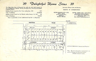
Flyer, Subdivision advertisement for sale of home sites - Ringwood, Victoria - 1956
Cardboard-backed advertisement for 39 home sites for sale, with location map, and summary of local real estate statistics in 1955 & 1956. Handwritten date noted in top right corner - 24th March, 1956.Subdivision map includes Reilly Street, Philip Street, Lorienne Street and Daisy Street in Heathmont. Surveyors: Messrs Little and Brosnan. Agents in conjunction: Peter Martin Pty. Ltd., Estate Agents, 55-57 Latrobe Street, Melbourne (Phone) FB 3571, FB 2783, and Peter Aubin Pty. Ltd., Auctioneers & Estage Agents, 345 Lonsdale Street, Dandenong (Phone) Dandenong 340, after hours Dandenong 932, 70. -
 Ringwood and District Historical Society
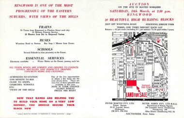
Flyer, Land Auction Advertisement adjoining Jubilee Park, Ringwood, Victoria - 1956
Folded double-sided brochure advertising residential land sale auction on Saturday 24th March (1956), with locality map and subdivision layout, terms of sale, and summary of local features and services. Subdivision includes Reilly Street Ringwood, and Philip Street, Daisy Street, and Lorienne Street Heathmont. Surveyors - Messrs Little and Brosnan. Agents in Conjunction - Peter Martin Pty. Ltd., Estate Agents, 55-57 Latrobe Street, Melbourne (Phone) FB 3571, FB 2783, and Peter Aubin Pty. Ltd. R.E.S.I., Auctioneers & Estate Agents, 345 Lonsdale Street, Dandenong (Phone) Dandenong 340, After Hours, Dandenong 932, 70.