Showing 548 items
matching drainage
-
 Flagstaff Hill Maritime Museum and Village
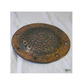
Functional object - Marine Drainage Cover, Mid to Late 20th century
A mass-produced brass marine or ship's fitting made for water drainage from a ship's deck or elsewhere on a marine vessel or for covering a ventilation hole. The brass marine fitting is significant as an example of equipment or furnishing used on a marine vessel in colonial times that is still made in modern times. Brass marine drainage cover, circular; Perforated convex cover with eight drilled screw holes around its wide collar. warrnambool, shipwreck coast, flagstaff hill, flagstaff hill maritime museum, flagstaff hill maritime village, ventilator cover, ventilator, drain cover, drain, marine fitting, ship's fitting, perforated brass cover -
 Canterbury History Group
Map - Victorian Railways, Canterbury, Drainage Plan, cc1910
Drainage plan around Canterbury Station, Canterbury Road and Maling Road .5 pages of photocopies from the Public Record Officecanterbury, canterbury road, maling road, canterbury station, drainage, stormwater channels -
 Numurkah & District Historical Society
Equipment - Delver
A grader-like blade attached to horses or a tractor to dig through the ground to create channels, especially drainage channels. Long metal plated "trough-shape" with raised edges, connected by metal bracketsfarming, delver, irrigation, channels, drainage -
Tatura Irrigation & Wartime Camps Museum
Book, The Rural Science Series, 1899
Descriptions of various farming and irrigation methods and drainage.Green cloth covered cardobard cover, black and red pattern and writing on the front cover.the rural science series, irrigation, drainage, king fh, bailey lh, tatura, books, reference, rural, industry -
 Ballarat Tramway Museum
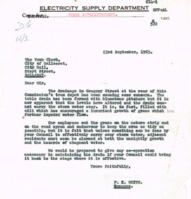
Document - Letter/s, State Electricity Commission of Victoria (SECV), 23/09/1965 12:00:00 AM
Yields information about the nature of correspondence between the SEC and the City re Council issues.Copy of a letter on Electricity Supply Department letterhead, quarto paper typed, from Engineer and Manager (Melbourne) to City of Ballarat, dated 23-9-1965, with a copy to the "Works Superintendent", about the condition of the drainage in Gregory St, storm water not getting away - stagnant. Signed F, K White as Manager,trams, tramways, city of ballarat, drainage, depot -
 University of Melbourne, Burnley Campus Archives
Plan, Burnley Gardens. City of Richmond. Parish of Jika Jika - County of Bourke, 1927
Part-coloured plan showing drainage, sewerage drains, taps and waterstops. Area bounded by Swan St. To N, Yarra River on E and Richmond Park on SW side. Contour lines of orchard depicted, laying pens and yards. Coloured area depicts pavilion with surrounding garden and paths layout pencilled in. Photo-Lithograph by Dept. of Lands & Survey, Melbourne by W. Butsonsewerage, drainage, lithograph, pavilion -
Whitehorse Historical Society Inc.
Article, Water woes, 1993
Problems with drainage systems in Nunawading would take 32 years to complete at the rate they were being fixed.Problems with drainage systems in Nunawading would take 32 years to complete at the rate they were being fixed. Residents in Irene Crescent and Wattle Valley Road will be charged and others will pay for new drains throughout the city.Problems with drainage systems in Nunawading would take 32 years to complete at the rate they were being fixed. city of nunawading, ward, kelvin, irene crescent, mitcham, wattle valley road, mitcham, drainage -
![Photograph - Construction of the F19 [Eastern Freeway], Ron Setford, May 1976](/media/collectors/550653872162f11fb04854aa/items/6828785464071e7c58e655d0/item-media/6828788e64071e7c58e657aa/item-fit-380x285.jpg) Kew Historical Society Inc
Kew Historical Society IncPhotograph - Construction of the F19 [Eastern Freeway], Ron Setford, May 1976
Ron Setford and his wife Grace Setford lived in Tanner Avenue, East Kew, from c.1946 to c.1995. A keen photographer, he recorded the changing face of Kew over a 20 year period. Apart from 30 photographs of built structures and places in Kew dating from 1960 and 1961, 145 of his 35mm colour slides chronicle the development of the F19 (later renamed Eastern) Freeway through the Yarra Valley in Kew over a five year period from c.1972 to c.1977. This important collection was donated to the Society by his granddaughter in 2025.This collection of 175 35mm slides is of local and statewide significance, owing to its subject matter, particularly the major development of road transport infrastructure during the 1970s with the construction of the Eastern Freeway. The photographer also took care to annotate and date most of his slides which enable the researcher to pinpoint temporal and spatial locations."Excavating drainage near Chandler Hwy"ron setford, eastern freeway, f19 freeway -
 Stawell Historical Society Inc
Photograph - Slide, Kaolin Mine Under Church Hill
two men in a drainage trench -
University of Melbourne, Burnley Campus Archives
Slide - Glass slide, 1891-1905
Scrubby gums and possible drainage line. -
 Kew Historical Society Inc
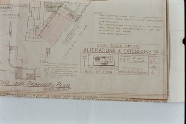
Slide - Architectural Drawing, Kew Public Offices, 1887
A civic campaign for new public offices developed in Kew in the 1880s. After much deliberation, the location chosen was the junction of Bulleen and Cotham Roads. The buildings were designed by George Watson and John Henry Harvey, architects within the Department of Public Works (Victoria). Building was commenced in 1887, and after one year, the buildings were opened. The Post Office was transferred to the new Commonwealth Government in 1901. The Police Station and Court House, sold by the Victorian Government to the City of Boroondara in 2007, are now a community cultural centre and performing arts venue.The buildings were listed on the Victorian Heritage Register Register (HO885) in 1991. They are historically and architecturally significant to the State Of Victoria because Watson and Harvey's designs exhibit diversity in integrating civil offices, they accommodate the apex of road junctions, and they demonstrate a departure from the contemporaneously favoured High Victorian Classical to the Queen Anne style in the design of civic buildings. 35mm colour transparency of an original plan by George Watson and John Henry Harvey, architects of the Department of Public Works (Victoria), in 1887 for New Public Offices at Kew. This plan was copied by the donor from an original held at the Commonwealth Archives in Brighton (Vic). The copy was made to illustrate a report that the donor made on ‘The functional planning design, building materials and construction methods of the Kew Post Office’ as part of course work at RMIT.SITE AND DRAINAGE PLAN / SCALE 16' TO 1"kew court house, kew police station, kew post office, architectural drawings, khs - slides, new public offices -- kew (vic.), architecture — queen anne style -
University of Melbourne, Burnley Campus Archives
Book - Register, Workbook: Burnley Gardens Record of Fieldwork, 1917-1918
Handwritten weekly fieldwork logbook from week ending 6 January 1917 to week ending 7 December 1918. Includes information about plants and crops, horticultural practices, drainage work undertaken. At the back, information on the dairy cows. Some parts very faded.weekly, fieldwork logbook, 1917, 1918, plants, crops, horticultural practices, drainage, dairy cows -
 Kew Historical Society Inc
Plan, Melbourne & Metropolitan Board of Works : Contour Plan of Melbourne & Suburbs : Melbourne Sewage, 1894
The Melbourne and Metropolitan Board of Works (MMBW) plans were produced from the 1890s to the 1950s. They were crucial to the design and development of Melbourne's sewerage and drainage system. This plan forms part of a large group of MMBW plans and maps that was donated to the Society by the Mr Poulter, City Engineer of the City of Kew in 1989. Within this collection, thirty-five hand-coloured plans, backed with linen, are of statewide significance as they include annotations that provide details of construction materials used in buildings in the first decade of the 20th century as well as additional information about land ownership and usage. The copies in the Public Record Office Victoria and the State Library of Victoria are monochrome versions which do not denote building materials so that the maps in this collection are invaluable and unique tools for researchers and heritage consultants. A number of the plans are not held in the collection of the State Library of Victoria so they have the additional attribute of rarity.Digital copy of an original MMBW plan. This contour plan shows the area identified by the MMBW for purposes of drainage and sewerage in 1894. The suburbs represented extend from Williamstown in the west to Bulleen in the east, and from Preston in the north, south to Sandringham. Suburbs are outlined in coloured ink. Red lines indicate main and branch sewers in existence at the beginning of 1894 in central and inner Melbourne. These extended as far as Williamstown and Brighton, but not yet as far as Kew, where sewering did not commence until 1901. Contour lines show the topography, which was important for indicating the fall of the land for the laying of sewers and drainage channels. Kew appears to be fairly undeveloped at this date except for railway lines and stations (the Kew and Outer Circle lines), main roads, the Kew Lunatic Asylum Reserve and Studley Park. However, the contour plan does not accurately represent the density of settlement, nor the large number of houses, which were being built in Kew and other suburbs from the 1850s to the land boom of the late 1880’s and early 1890’s. This plan is part of a large and historically significant group of MMBW plans and maps that was donated to the Society by the Mr Poulter, City Engineer of the City of Kew in 1989.mmbw contour plan of melbourne and suburbs, melbourne and metropolitan board of works, melbourne sewage, cartography -
Glenelg Shire Council Cultural Collection
Plan - Plan - Portland Sewerage Association, n.d
Portland Sewerage Authority Plan of Drainage for Mrs M Campbellcampbell family records -
Port Melbourne Historical & Preservation Society
Plan - Drainage Improvements, Ross Street, Port Melbourne, Borough of Port Melbourne, 3 Nov 1892
Plan of Ross Street drainage improvement diversion drain, 1892.Signatures of J. J. Bartlett (Mayor), A. V. Heath (Borough Surveyor), W. Harrison, Laurence Brady (Contractor)engineering - canals and drainage, james john bartlett, arthur victor heath, town clerks, w harrison, laurence brady -
 Port Fairy Historical Society Museum and Archives
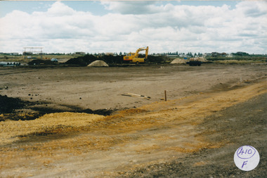
Photograph
South Beach Development Coloured photograph of Drainage works with pipes at the left and large machine 410/F (sticky label now removed 2021)south beach, development, earth works, equipment, digger -
Port Melbourne Historical & Preservation Society
Plan - Drainage, Board of Works, William Pentland (Coach builders), corner Ingles Street and Crockford Street, 21 Dec 1939
Board of Works drainage plan for William Pentland (coach builders) 1939built environment - industrial, sue pentland, william pentland -
 Melbourne Tram Museum
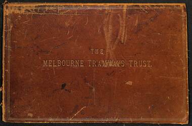
Document - Folder, Kemp & Boyce Printers, "Melbourne Tramways Trust - Cable Tramways", March 1889
Plans and documents prepared by George Duncan for the Melbourne Tramways Trust showing details of the track construction, drainage and costs for the construction of the Melbourne cable tram and horse tram system for the Melbourne and Tramway Omnibus Co. Part 1 - track cross sections for both cable and horse trams and various rail weights - lbs/yard part 2 - details costs and mileages for each liine, report from George Duncan and remnant part of a printed map missing the lower half. part 3 - drainage report detailing the works and cost for each line. part 4 - continuation of drainage report - and last part of the book Map printed on cloth - blue print - showing the various lines. Note the Windsor to St Kilda line shown as a horse tram line, but was built as a cable line - the last to be opened.Yields information about the construction of the cable tram system by the Melbourne Tramway TrustFolder - heavy card leather covered covers with gold lines around the edges and gold blocked title. Has marbled glued end papers, containing 9 cloth backed blue print drawings, 22 printed sheets and two foldout maps. The lower half of the first fold out map has been torn out and lost. The second fold out map, a cloth backed blue print.Date stamped in two places with "The Melbourne Tramways Trust Engineers 9 Mar 89" (1889), in two places.tramways, trams, cable trams, mtt, mtoco, melbourne tramway trust, construction, drainage, maps, george duncan, track work, costs -
Port Melbourne Historical & Preservation Society
Plan - Open drainage channel, cnr Beach Street and Railway Place, Port Melbourne, Frederick William Bull, Principal Surveyor, 1862
Plan for open drainage channel at corner of Beach Street and Railway Place, 1892."Open Channel at Foot of Railway Place":Signed by Frederick William Bull, Principal Surveyorengineering - canals and drainage, engineering department - borough of sandridge, frederick william bull, business and traders - hotels -
 Coal Creek Community Park & Museum
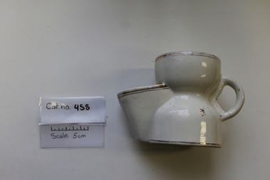
Domestic object - Shaving Mug
White ceramic shaving mug with gold rim with drainage shelf for shaving brush.On base: BRITTANIA POTTERY ENGLAND ...?????....447 -
 Ringwood and District Historical Society
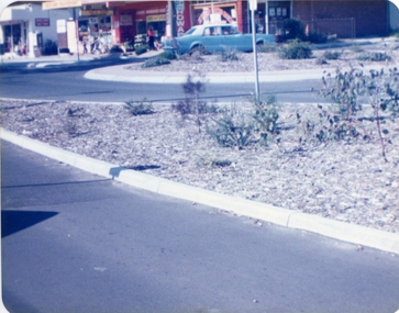
Photographs, East Ringwood Shops in Railway Avenue circa 1980s (6 photos), 1997
Colour photos of the Ringwood East shopping centre. Query drainage works and autumn trees.East Ringwood shops - hardware shop at roundabout (3274_001); East Ringwood shops - post office (3274_002); East Ringwood shops - Paul's supermarket (3274_003); East Ringwood shops - unknown street (3274_004); East Ringwood shops - Lawrence Grove corner (3274_005); East Ringwood shops - Wright Bros (3274_006) -
Port Melbourne Historical & Preservation Society
Plan - Johnson Street from Graham Street to Danks Street, Borough of Port Melbourne, 25 Jul 1890
Plan of Johnson Street, from Graham Street to Danks Street. (including Drainage Sections)Michael Minahan (?) Contractor, 25-7-1890engineering - roads streets lanes and footpaths, michael minahan -
Whitehorse Historical Society Inc.
Map, Eastern Freeway Extension, 2002
Extension of Eastern Freeway: Plan of Deep Creek Road paths, drainage and alignment plan.Extension of Eastern Freeway: Plan of Deep Creek Road paths, drainage and alignment plan.Extension of Eastern Freeway: Plan of Deep Creek Road paths, drainage and alignment plan.deep creek road, mitcham, eastern freeway extension, eastlink -
 Whitehorse Historical Society Inc.
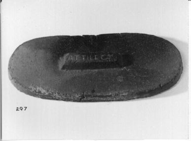
Functional object - Earthenware Pipe Lid
Red brick rectangular shaped earthenware lid for drainage/sewerage pipes. Partly glazed.AT Tile Co.ceramics, earthenware -
Port Melbourne Historical & Preservation Society
Plan - Drainage works, cnr Crockford and Raglan Streets, Sandridge, George Kelly, Borough Surveyor, 3 Jun 1864
Sectional plan for drainage work after flood 1864. Corner Crockford Street and Raglan Street.Borough of Sandridgeengineering department - borough of sandridge, engineering - canals and drainage, business and traders - hotels, george kelly -
Port Melbourne Historical & Preservation Society
Plan - Drainage works, cnr Crockford and Raglan Streets, Sandridge, George Kelly, Borough Surveyor, 6 Jun 1864
Ground plan for drainage work after flood 1864. Corner Crockford Street and Raglan Street.Borough of Sandridgeengineering department - borough of sandridge, engineering - canals and drainage, business and traders - hotels, george kelly -
Lakes Entrance Historical Society
Book, Department of Natural Resources and Environment, Request for Tender- Recreation Earthworks in the Colquhoun Forest, 2002
Tender specifications for recreation earthworks in the Colquhoun Foret, including pathways and drainage. Contains location map.government, recreation -
 Ringwood and District Historical Society
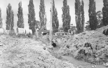
Photograph, Ringwood Lake Overflow Pipe
Black and white photograph of drainage works. Poplars in the background. Equipment and men on roadway above open pipe.Typed below photograph, "Ringwood Lake overflow pipe (Passing under Maroondah Highway) 1963". -
Port Melbourne Historical & Preservation Society
Plan - Drainage, 50 Beach Street, Port Melbourne, 18 Jan 1899
Photocopies (2) of black / white plan of drainage for Mr Warren, 50 Beach Street Port Melbournemmbw, melbourne and metropolitan board of works, f t warren -
Port Melbourne Historical & Preservation Society
Plan - Drainage, Board of Works, William Pentland (Coach builders), corner Ingles Street and Crockford Street, 8 Mar 1905
Board of Works drainage plan for William Pentland (Coach builders) at Ingles St and Crockford St corner. 1905built environment - industrial, sue pentland, william pentland