Showing 215 items matching "dunes"
-
 Federation University Historical Collection
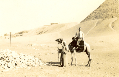
Photograph - Black and White, Frank Wright at the Pyramids, 1940, May 1940
Frank Wright was a renown resident of Smeaton, where he was born. He lived at Laura Villa, and attended Smeaton State School. His father William was a gold miner and his mother's name was Sarah. Their family won many singing and instrumental awards. Frank was tutored by Percy Code and was awarded a gold medal for the highest marks in the ALCM examinations in the British Colonies at the age of seventeen years. He became the Australian Open Cornet Champion by the age of eighteen. A year later, Frank conducted the City of Ballarat Band, and later the Ballarat Soldiers’ Memorial Band. He formed the Frank Wright Frisco Band and Frank Wright and his Coliseum Orchestra. These bands won many South Street awards, and Frank as conductor won many awards in the Australian Band Championship contest. In 1933 Frank Wright sailed to England to conduct the famous St Hilda’s Band and was later appointed Musical Director of the London County Council, where he organized many amazing concerts in parks, in and around the London district. He was made Professor of Brass and Military Band Scoring and conducted at the Guildhall of Music and Drama. Frank was often invited to adjudicate Brass Band Championships around Europe, in Australia, including South Street and in New Zealand. The Frank Wright Medal at the Royal South Street competition is awarded to an individual recognized as making an outstanding contribution to brass music in Australia.Black and white photograph of a man sitting on a camel with the keeper standing at the camel's head. To the left is a pile of rocks and the rest of the background is sand rising to a dune and to the right is part of an Egyptian pyramid. The man is Frank Wright.Written in pencil on back - At the Pyramids, May 1940frank wright, egypt, pyramid, sand dune, camel -
 Lakes Entrance Historical Society
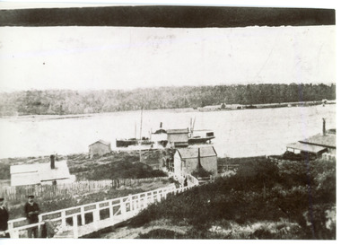
Photograph - New Works, 1910c
Also two other black and white copies 9 x 13 cmSepia photograph showing buildings on dunes at New Works. Building on left is works office, centre is school, right is harbour master's home. Steamer at wharf, boardwalk with two men. Lakes Entrance VictoriaLakes Entrance (New Works Jetty)boardwalk, waterways, historic site -
 Lakes Entrance Historical Society
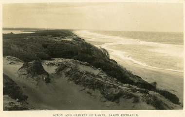
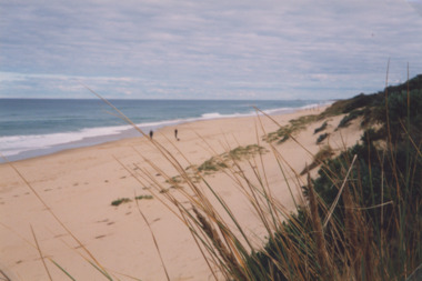
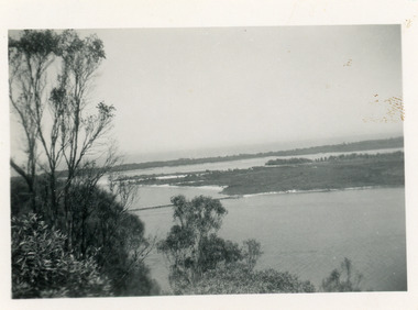
Postcard - Sand Hummocks, Bulmer H D, 1940
Black and white postcard taken from the hummocks to the west. View is looking to the east showing ocean and beach, wind swept scrub covered dunes, and distant view of Gippsland Lakes. Lakes Entrance Victoriawaterfront, ocean, topography -
 Lakes Entrance Historical Society
Photograph - Footbridge, Holding M, 1985c
Colored photograph of the footbridge. It shows seagulls on the weed covered northern edge of the lake, people on bridge, roof of surf lifesaving club house visible among dunes of south shore. Lakes Entrance Victoriawaterways, bridges -
 Lakes Entrance Historical Society
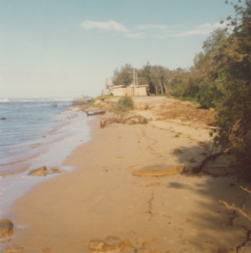
Photograph - Ocean Beach, Lakes Post Newspaper, 1/06/2000 12:00:00 AM
Colour photograph taken from Eastern Beach looking towards the west showing expanse of sand between calm ocean and shrub covered coastal dunes, two people on sand Lakes Entrance Victoriacoast, ocean, waterways -
 Lakes Entrance Historical Society
Photograph - Lake Tyers, Marie Fish, 1978
Two other colour photographs taken of damage from storms June/July 1978 showing that sand dune between lake and ocean was swept away, road and toilet block undermined numbers 03831.1 and 3831.2 size 9 x 8.5 cmColour photographs showing damage to shore and track to entrance at Lake Tyers Beach Victoriabeaches, waterways -
 Lakes Entrance Historical Society
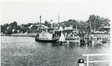
Photograph - P.S. Tanjil, 1920c
Black and white photograph showing cottages on dunes. Small sail boat in front of P S Tanjil at jetty. End of New Works wharf on lower right hand corner of photo. Lakes Entrance Victoriaboats and boating, jetties -
 Lakes Entrance Historical Society
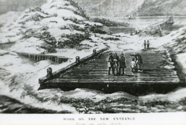
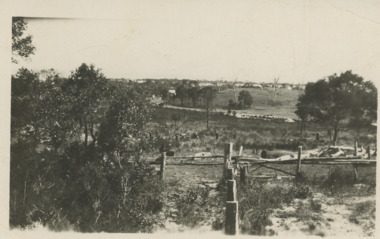
Photograph - Entrance Works, 1880c
Photographed from an early sketchBlack and white photographic postcard showing work in progress on building of entrance piers. On partially built pier, workmen standing on decking, sand dunes and lake at back and Jemmys Point in background. Lakes Entrance VictoriaWork on the new entrance, from an early sketch waterways, public works, piers -
 Lakes Entrance Historical Society
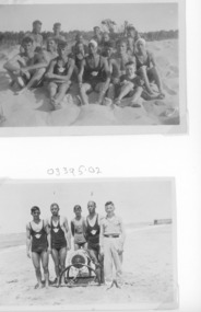
Photograph - Surf Lifesaving, 1938
Also in album eight other black and white photographs of lifesavers posing with ropes and reel practising first aid and resuscitation 1938 c. 6 x 8.5Two small format black and white photographs of people from Surf Life Saving Club, posing for photograph on sand dunes. Two persons named, Tommy Todd and Jack Mitchelson. Lakes Entrance Victoriavolunteering, community services, emergency services -
 Lakes Entrance Historical Society
Photograph - Snake Island, 1950c
Also two other copies 7 x 11Black and white photograph showing eastern end of Rigby Island, Snake Island, and dunes at Lakes Entrance, Victoria. Reeves River below, foreground bushes, Hopetoun Channel in middle distance, Bass Strait in distance. waterways, topography, islands -
 Lakes Entrance Historical Society
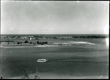
Photograph, Lakes Entrance, 1930 c
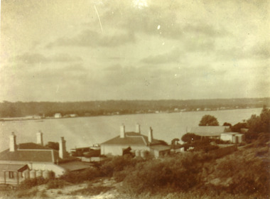
Black and white photograph taken from north of township looking toward town and front lake and sand dunes. Roadway in middle distance is Myers Street known as Allens Hill in 1930 Lakes Entrance Victoriatownship, roads and streets -
 Lakes Entrance Historical Society
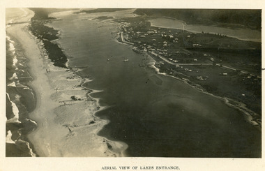
Photograph - Lakes Entrance, 1923c
Two copies 16.5 x 25.5 very darkBlack and white photograph showing early aerial view of township of Lakes Entrance, photo shows highway going along Myer Street and along Roadknight Street, no shops in Myer Street appears to be no foot bridge, therefore taken prior to 1937, sparce vegetation on foreground dunes, four barriers built on dunes to stop erosion through sand, two masted sailing boat in lake. Bullock Island in distance appears very small, Snake Island of Rigby Island in centre distance. Lakes Entrance VictoriaAerial View of Lakes Entrancewaterways, coast, aerial photograph, islands, township -
 Glenelg Shire Council Cultural Collection
Photograph - Photograph - Aerial view of coastline around Portland, Victoria, c. 1954
Black and white aerial photograph of coastline around Portland. Black border, scale all sides, 5 rows of 3 't' at regular intervals. Top half is ocean, bottom half is ? beach; sand dunes, cliffs.Front: '607 - 61 ' - handwritten, white, border 'RUN 7 PORTLAND', printed, white, border -
 Lakes Entrance Historical Society
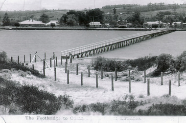
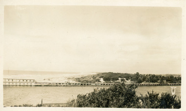
Photograph - Footbridge, 1937c
Two other copies 6.5 x 9 imageBlack and white photograph showing waterfront, Esplanade, some buildings and background hill almost completed footbridge across Cunninghame Arm. Posts defining pathway over sand dune to ocean beach. Lakes Entrance VictoriaFootbridge to Ocean Beach, Lakes Entrancewaterways, bridges, township -
 Bendigo Historical Society Inc.
Postcard - BLANCHE SLY POSTCARD COLLECTION, 1900 - 1920
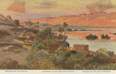
Postcard Album of Blanche Sly. Postcards stored in Folder 81 (49 postcards). 1403.1 - 1403.28 Grey linen look cover with picture of a small sailing boat pasted centre front pf cover. Partly torn sticker on lower LH corner. Blanche Victoria SLY Born: 11 Oct 1890, daughter of William and Hannah Sly Address: 1913; Loddon Vale Address: 1980; 100 Barnard Street Bendigo Died: Bendigo 12 June 1982, buried Bendigo G3 William Sly: Born: 1856 at Smythesdale, Victoria Married in Victoria in 1887; Hannah Theilman Died: Bendigo 1937, buried Bendigo G1 Hannah Sly Nee Theilman Born: 1866 Married in Victoria in 1887; William Sly Died: Bendigo 1948, buried Bendigo G3 See additional Research .Postcard Album of Blanche Sly containing 49 postcards. See 1403 Coloured painting of a landscape of the river Nile near Assuan. Egypt Small village with palm trees on near bank and desert dunes on far bank. . Addressee - Mrs. W Sly, Loddon Vale, via Pyramid, Victoria Sender - Pte S Olgaiti Not datedpostcard, collector, blanche sly -
 Lakes Entrance Historical Society
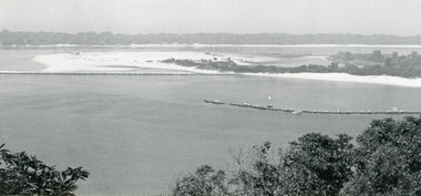
Photograph - Rigby Island, 1955c
Black and white photograph showing east end of Rigby Island, sand build up on Snake Island and rock groynes at Lakes Entrance, Victoria. Shrubbery in foreground, rock groynes in Reeves Channel, sand dunes in background.waterways, ocean, islands -
 Lakes Entrance Historical Society
Photograph - Fraser Island, Holding M, 2000c
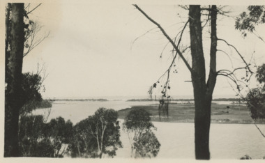
Colour photograph of Fraser Island, Gippsland Lakes, taken from Nyerimilang. It shows Flannagan Island mid centre, residence on Fraser Island, scrub covered dunes of southern shore of lake system. Lakes Entrance Victoria waterways, topography, islands -
 Lakes Entrance Historical Society
Photograph, Vera Bennett, Lady Harriet barge, Lakes Entrance Victoria, 14/06/1989 12:00:00 AM
Also a second photograph showing notice inside barge 04674.1 10 x 15 cmSepia toned photograph showing Lady Harriet barge moored at P.O. wharf on Cunninghame Arm, bullock Island and sand dunes in distance, Lakes Entrance Victoria. Also a second photograph showing notice inside barge Old stone barge that transported stone from Mississippi Creek Auary at the P.O. Jetty 14. 6. 89boats and boating, jetties, waterways -
 Lakes Entrance Historical Society
Postcard, Bulmer, Scene from Jemmys Point, 1900 c
Black and white postcard showing view from Jemmys Point of east end of Rigby Island and Reeves channel the entrance and sand dunes with Hope channel in distance Lakes Entrance Victoria.Also another copy of same postcard township, waterways, islands -
 Lakes Entrance Historical Society
Photograph - Footbridge, 1993c
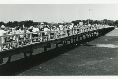
Black and white photograph showing crowd of tourists walking over footbridge, during the Clear Water Festival, water in foreground is known as Cunninghame Arm. Surf lifesaving club building visible on sand dunes. Lakes Entrance Victoriabridges, waterfront, festival -
 Lakes Entrance Historical Society
Photograph - Carpentertown, Phillips, Miss L, 1900c
Also black and white copy 9 x 14 cmSepia photograph showing lake, Cunningham Arm, in front of three houses on dunes at New Works. House on left is harbour masters, centre is harbour engineer's house and on right is house of contractor John Carpenter. Lakes Entrance Victoriajetties, waterfront, historic buildings -
 Lake Bolac & District Historical Society
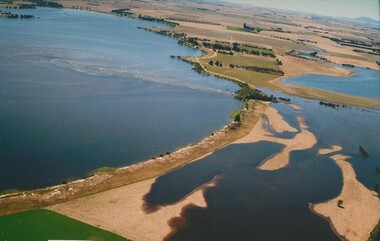
Colour photograph, Jan. Flood of Fiery Creek Inlet and Lake Bolac
January, 2011. Floodwaters entering Lake Bolac through the Fiery Creek inlet. This shows the accumulation of water behind the barrier dunes and the strength of the flood entering the lake through the narrow debouchment. The aboriginal midden can clearly be seen in the front left to centre of the photograph. Photograph courtesy James Davidson.lake bolac, fiery creek, 2011 flood, midden -
Lakes Entrance Historical Society
Photograph, Eastwood Bros, 1889c
Sepia photograph showing the just opened Entrance to Bass Strait. Sand not completely cleared from channel, buildings on dunes, dredge Wombat moored off Bullock Island. Rock groynes being built in lake. Lakes Entrance Victoriawaterways, islands, jetties, houses -
 Lakes Entrance Historical Society
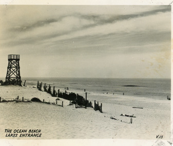
Postcard - Ocean Beach, 1950c
Black and white small format postcard of the ocean beach. It shows an expanse of sand dune, remains of a brush windbreak fence, and the observation tower, built for Royal Lifesaving Club, pre Surf Life Saving Club. Lakes Entrance VictoriaThe Ocean Beach Lakes Entrancebeaches, surf lifesaving -
 Lakes Entrance Historical Society
Photograph - Western Pier
Also one black and white copy 9 x 15Sepia photograph showing wooden Western pier at entrance from ocean into the Gippsland Lakes, with dunes in background foreground shows top ridge of roof of rocket shed on left and shipwreck bell on far right foreground. Lakes Entrance Victoriawaterways, piers -
 Lakes Entrance Historical Society
Photograph - Bullock Island, Silver Reflections Studio, 1920c
Black and white photograph showing Bullock Island, Entrance to Bass Strait, buildings on sand dunes, yacht sailing on Cunninghame Arm, tourist launch in foreground, rock groynes around west end of Bullock Island. Lakes Entrance Victoriawaterways, room display, islands -
 Lakes Entrance Historical Society
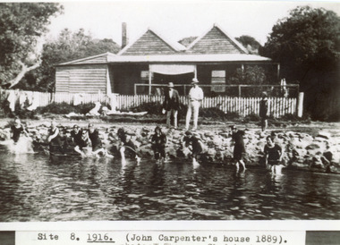
Photograph - Carpentertown, Sale, 1916c
Girls in water are in neck to knee swim suitsBlack and white photograph showing twin gable Carpenter House on dunes at New Works. Nine girls at waters edge preparing to swim, and two men and child on rocks. Picket fence across front of house. Lakes Entrance VictoriaSite 8 1916 (John Carpenter's house 1889) photo: W. Thomson, Clydebank, Sale. houses, waterways, recreation -
Glenelg Shire Council Cultural Collection
Magazine - Magazine Article, Australian Off-Road Action, c. 1981
Pages 15 - 26 of 'Australian Off-Road Action' magazine. White, black print and photographs. Pages 16 -26 is an article title 'Portland - the venue' documenting the history of the Portland Dune Buggy Club from its formation inv 1969 -
 Lakes Entrance Historical Society
Photograph - Western sand Hummocks, 1946
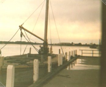
Black and white photograph showing lake shoreline on western side of entrance piers, with rock retaining wall, walings and crane left middle distance and front of Schnapper cottage, dense vegetation on dune and some erosion to beach. Lakes Entrance Victoria machinery, waterfront, houses -
 Lakes Entrance Historical Society
Photograph - The Entrance, 1930c
Black and white photograph showing wooden piers at entrance to Bass Strait from the Gippsland Lakes. Buildings on sand dunes, Bullock Island and rock groynes. Photo taken from Jemmys Point showing shrubbery in foreground. Lakes Entrance Victoriawaterways, topography, boats and boating, islands