Showing 1371 items
matching east side
-
 Lakes Entrance Historical Society
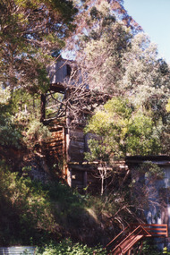
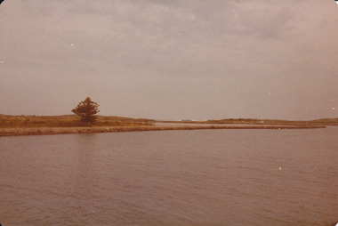
Photograph - McCrae's Lime Kiln, 1999
... Colour photograph of the McCrae Lime Kiln site east side... photograph of the McCrae Lime Kiln site east side shows work site now ...Site of lime burning operations from 1870's. Lime burnt for agricultural purposes. Cocky Roberts was using lime in his glass making business at Lakes Tyers.Colour photograph of the McCrae Lime Kiln site east side shows work site now encroached on by bushland. Toorloo Arm Victoriahistoric site, local history -
 Lakes Entrance Historical Society
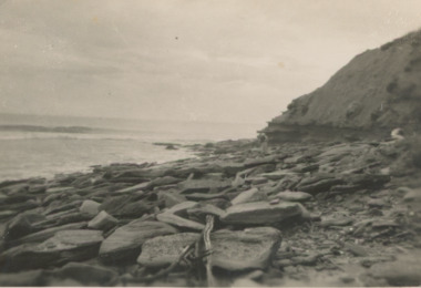
Postcard - Red Bluff, 1940c
... Black and white postcard small format of east side of Red... of east side of Red Bluff rocks and driftwood at the base, calm ...Black and white postcard small format of east side of Red Bluff rocks and driftwood at the base, calm sea Lake Tyers Victoriatopography, ocean -
 Eltham District Historical Society Inc
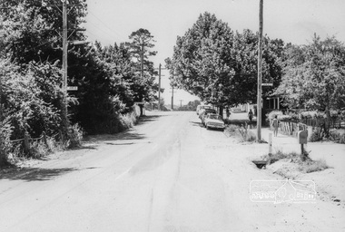
Photograph, Looking North along Main Road near intersection with John Street, Eltham, February 1968, Feb 1968
... Shows cars parked outside Burgoyne's store on the east side ... melbourne Shows cars parked outside Burgoyne's store on the east ...Shows cars parked outside Burgoyne's store on the east side In February 1968 an unknown person took a series of photos from the Eltham Hotel at Pitt Street heading north along Main Road through the shopping centre to just north of Elsa Court covering the length of the section of Main Road which was duplicated shortly thereafter. Shows the condition and environment of the streesscape of Main Road, Eltham immediately prior to the duplication between Pitt Street and Elsa Court through the shopping centre. Also shows a number of shops and businesses that operated at that time.Black and white photographduplication, eltham, main road, burgoyne's shop, john street -
 Eltham District Historical Society Inc
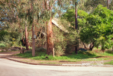
Photograph, 41 Antoinette Boulevard, cnr of Main Road, Eltham, c.May 2001
... East side of Main Road near Diamond Creek Bridge... melbourne East side of Main Road near Diamond Creek Bridge eltham ...East side of Main Road near Diamond Creek BridgeRoll of 35mm colour negative film, 7 stripsAgfa HDC 200 plus-2eltham, streets, main road, antoinette boulevard -
 Port Fairy Historical Society Museum and Archives
Photograph
... East side of training walls looking to South West passage... Street Port Fairy great-ocean-road East side of training walls ...East side of training walls looking to South West passageColoured photograph of View of south west passage with Norfolk Island pinetrading walls, south west passage -
 Phillip Island and District Historical Society Inc.
Photograph, 1978/79
... . It was situated in Thompson Avenue on the east side near Chapel Street... in Thompson Avenue on the east side near Chapel Street and the Phillip ...Built as a home for Mrs Jessie Smith - it was later used as a billiard room and finally as the Penguin Cafe. Mrs Smith was a member of the 'Small' Family of San Remo. She was the only Estate Agent in Cowes until 1954. Mrs Smith was in her late nineties when she died in 1977.The Penguin Cafe was built as a home for Mrs Jessie Smith. It was situated in Thompson Avenue on the east side near Chapel Street and the Phillip Island Bakery.local history, photographs, buildings, historic, buildings - historical, coloured photograph, john cook, phillip island, penguin cafe, cowes -
 Glenelg Shire Council Cultural Collection
Photograph - Photograph - Main Breakwater Construction, n.d
... Black & White photo, east side of main breakwater under... Breakwater Back: Main Breakwater - pencil Black & White photo, east ...Port of Portland Authority ArchivesBack: Main Breakwater - pencilport of portland archives, portland harbour, breakwater -
 Linton and District Historical Society Inc
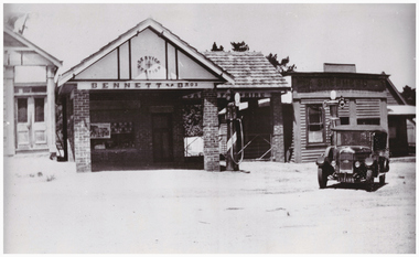
Photograph, Bennett's Garage and Shepherd's Shop, Sussex Street, Linton, circa 1940
... Information in the "Linton - Sussex Street East Side" file...Information in the "Linton - Sussex Street East Side" file ...Information in the "Linton - Sussex Street East Side" file says that Bennett Bros opened their garage in Sussex Street in 1928. Information in the "Linton - Sussex Street East Side (Title Searches)" file shows that Mrs Violet Annie Shepherd bought the property next to the garage in 1939.Black and white photograph which shows Bennett Bros service station (a brick building), next to Shepherd's "greengrocer and confectionery" store (a weatherboard building), in Sussex Street, Linton. There are two petrol bowsers outside the garage, and a car parked in the street in front of Shepherd's shop. A sign across part of the garage building reads "CARS FOR HIRE".bennett bros garage, shepherd's greengrocer and confectionery shop, buildings, shops, sussex street linton -
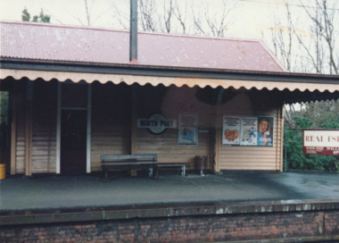
 Port Melbourne Historical & Preservation Society
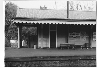
Photograph - North Port railway station, day of last train from Port Melbourne, Joan Curtis, c. 1991
... from Port Melbourne, October 1987: east side (Bay bound..., photographed day of last train from Port Melbourne, October 1987: east ...Photographed by Joan CURTIS on the last day the trains ran. Prints made by Pat Grainger from Joan's negs during the 'Vintage Port' Project, 1990North Port railway station, photographed day of last train from Port Melbourne, October 1987: east side (Bay bound), northern endDetails in black ink on backtransport - railways, built environment, joan curtis -
 Port Melbourne Historical & Preservation Society
Photograph - North Port railway station, day of last train from Port Melbourne, Joan Curtis, c. 1991
... from Port Melbourne, October 1997: east side (Bay bound..., photographed day of last train from Port Melbourne, October 1997: east ...Photographed by Joan CURTIS on the last day the trains ran. Prints made by Pat Grainger from Joan's negs during the 'Vintage Port' Project, 1990North Port railway station, photographed day of last train from Port Melbourne, October 1997: east side (Bay bound), southern endDetails in black ink on backtransport - railways, built environment, joan curtis -
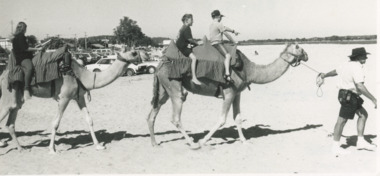 Lakes Entrance Historical Society
Photograph - Camel Rides Lakes Entrance, Lakes Post Newspaper, 1/01/1995 12:00:00 AM
... taken during camel rides on the east side of Cunninghame Arm... of three riders and two camels taken during camel rides on the east ...Black and white photograph of three riders and two camels taken during camel rides on the east side of Cunninghame Arm Footbridge Lakes Entrance Victoriarecreational facilities, tourism -
Glenelg Shire Council Cultural Collection
Photograph - Photograph - Main Breakwater construction, Portland, 30/06/1953
... taken 30.6.53 Subject - Main Breakwater East Side... Subject - Main Breakwater East Side Black & white photo of main ...Port of Portland Authority ArchivesBack: Purple PHT Stamp - Print No 4/17 Neg. No 158 Date taken 30.6.53 Subject - Main Breakwater East Sideport of portland archives, main breakwater, construction, portland harbour, harbour development, lady bay -
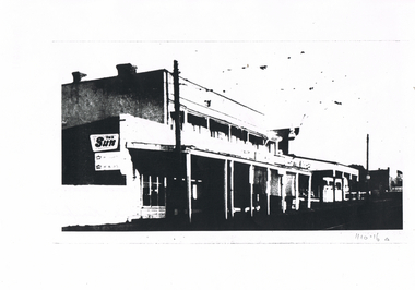 Bendigo Historical Society Inc.
Document - LONG GULLY HISTORY GROUP COLLECTION: MAIN STREET, LONG GULLY
... between Daly and Creeth St, east side. Buildings have verandas... of Long Gully between Daly and Creeth St, east side. Buildings ...BHS CollectionBlack and white photocopy of Main Street of Long Gully between Daly and Creeth St, east side. Buildings have verandas. One has an advertisement for The Sun. Written on the back is -Main Street of Long Gully Between Daly & Creeth St East side. Eaglehawk Road. Showing Les Norris Davey Bros Grocer Mixed Business Howard White furniture Manufacturer.bendigo, history, long gully history group, the long gully history group - main street long gully, les norris, davey bros, howard white -
 Kew Historical Society Inc
Plan - Subdivision Plan, J R Mathers & McMillan, Heart of Richmond Estate : Richmond, 1928
... "In 1928 the land on the east side of Johnson Street... "In 1928 the land on the east side of Johnson Street was subdivided ..."In 1928 the land on the east side of Johnson Street was subdivided in 60 lots for the ‘Heart of Richmond Estate’. The houses in the subdivision, along the east side of Johnson Street, and in the newly created Hollick, Cole and Kennedy streets were constructed from 1928 to 1937." (Source: City of Yarra Heritage Gaps Review One 2013)Portion of subdivision plan pasted on to cardboard. Area includes Johnson Street, Victoria Street, Kennedy Street, Cole Street, Hollick Street, Bennett StreetTitle Certificate Vol.2381, Folio 476130 Phillips, Fox & Masel, 440 Little Collins Street, Melbourne (Local estate agent: Jas. R. Mathers & McMIllan, 136 Cotham Road, Kew)subdivision plans - richmond (vic.), heart of richmond estate -
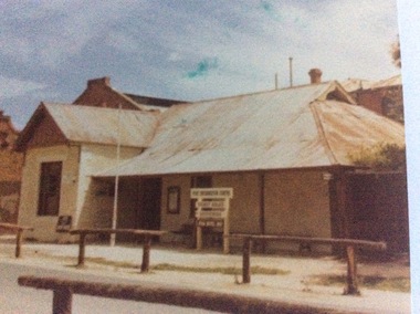 Port of Echuca
Colour photograph, 1979
... Esplanade. The photograph is taken from the east side of the street... is taken from the east side of the street. The Shackell's Bond ...The Star Hotel was built in 1863 as a private dwelling, by James Shackell who owned the Bond Store, next door. It was a small house consisting of only a couple of rooms. In 1867 Joseph Salomon bought the house and converted it into a hotel. He built an underground bar to "deal with the peculiarities of the Echuca climate". It was called 'The Shades'. In 1890 Jane Pygall bought the hotel, which was described by the Riverine Herald as having ' three parlours, seven bedrooms, underground bar, kitchen, bathroom, outhouses, small stables, and entrance from two streets." She changed the name to The Esplanade Hotel. In 1890 it was de-licensed along with many hotels in Echuca. It had been a very popular drinking place for all the wharf workers, who continued to to drink illegally in the underground bar. It was then that the escape tunnel to the laneway was built , so the drinkers could escape the Police raids. For many years it was a private dwelling, or an office. In 1973 the City of Echuca bought the Star Hotel and resored it. At the time this photograph was taken it was the main tourist information centre for the Port of Echuca. It now operates as a hotel, serving meals and providing performance opportunities for musicians.The Star Hotel is very significant in Echuca's history due to its proximity to the Echuca Wharf. It was the closest bar to the wharf. Despite Jane Pygall trying to improve the quality of her clientele, the wharf drinkers preferred to drink at The Star Hotel, as the Bridge Hotel catered for more upmarket clientele. After de-licensing in 1897, the workers continued to drink at The Shades Bar and even put in place elaborate strategies to enable them to drink illegally there. It is now a large eating and entertainment site, and the public are still able to visit 'The Shades Bar'.A coloured photograph of the Star Hotel building in Murray Esplanade. The photograph is taken from the east side of the street. The Shackell's Bond Store can be seen on the left of the photograph. Printed on the back are the words, "This paper manufactured by Kodak". Also on the back is green Port of Echuca stamp. Written across the front of the Bond Store are the words 'World In Wax Museum.' On a sign outside the Star Hotel are the words, "Port Information Centre. Ticket Sales. Souvenirs . Star Hotel 1867."port of echuca, star hotel, shackell, james, salomon, joseph, pygall, jane, esplanade hotel, 1863, underground bar, the shades, de-licensing of echuca hotels -
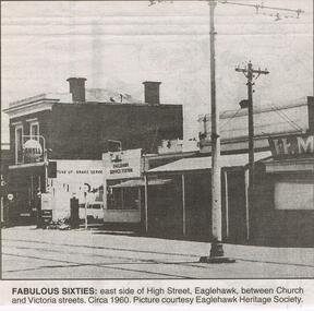 Bendigo Historical Society Inc.
Newspaper - JENNY FOLEY COLLECTION: FABULOUS SIXTIES
... sixties: east side of high Street, Eaglehawk, between Church... "The way we were" from 1999. Fabulous sixties: east side of high ...Bendigo Advertiser "The way we were" from 1999. Fabulous sixties: east side of high Street, Eaglehawk, between Church and Victoria streets. Circa 1960newspaper, bendigo advertiser, the way we were -
 Peterborough History Group
Photograph - Photographs of The Bridge over The Curdies River
... of the Bridge over the Curdies River, both taken from the East side... the East side showing different water levels in the river ...Historic views of the old wooden bridge, since replaced, and also showing the configuration of the river at that time.River and bridge integral part of Peterborough life. Digital image of two black and white photographs of the Bridge over the Curdies River, both taken from the East side showing different water levels in the rivercurdies river, curdies river bridge peterborough, peterborough victoria, great ocean road, curdies river estuary -
 Melton City Libraries
Photograph, The Willows, 1973
... Corner view of front and east side showing telephone... Architecture Corner view of front and east side showing telephone ...Corner view of front and east side showing telephone insulator connection, and small elevated water tank connected to windmill. This photo was taken before the restoration of the property. local identities, local special interest groups, council, local architecture -
 Linton and District Historical Society Inc
Photograph, Murrell's Newsagency, Sussex Street, Linton, circa 1940
... the east side of Sussex Street, including Murrell's newsagency... photograph which shows buildings along the east side of Sussex Street ...William Murrell ran a newspaper shop on the west side of Sussex Street until 1932, when he moved his business to a site formerly occupied by Dan Cornish (who ran it as a shoe shop). After William Murrell died the newsagency was run for many years by his daughter Carrie Murrell.Black and white photograph which shows buildings along the east side of Sussex Street, including Murrell's newsagency, the fire brigade building, and another shop or dwelling.murrell's newsagency, linton fire brigade building, buildings, shops, sussex street linton -
Tarnagulla History Archive
Photograph - Photograph: Masters, Tarnagulla, c. 1890s
... This business and building once stood on the east side... stood on the east side of Commercial Road, Tarnagulla. Williams ...This business and building once stood on the east side of Commercial Road, Tarnagulla. Williams Family Collection. Monochrome photograph of Philip Masters, carpenter and undertaker, and another man in front of Masters' business premises in Tarnagulla, Victoria. A small cottage can be seen behind the store. An original photograph, mounted on card. Handwritten on back: 'Tarnagulla & District' tarnagulla, education, school, children -
 Peterborough History Group
Photograph - Four copies of photographs of the Peterborough Old Bridge
... connection to the East side of the river. A view of the landscape... to the East side of the river. A view of the landscape at that time ...Varying views of the old bridge, which was a valuable connection to the East side of the river. A view of the landscape at that time.Historic views of the town and bridge 4 photocopied reproductions of different aspects of the Old bridge at Peterborough, including one which is a copy of The Rose Series Postcards No P2470.peterborough, peterborough old bridge, curdies river bridge, rose series postcards, rose series p2470 -
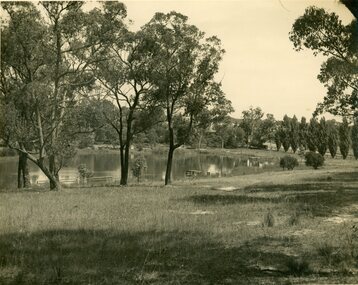 Ringwood and District Historical Society
Photograph, R. Pullin, Ringwood Lake 1946, 1946
... lake from east side. Maroondah Highway can be seen on right... by R. Pullin looking across lake from east side. Maroondah ...Ringwood Lake 1946, photograph by R. Pullin looking across lake from east side. Maroondah Highway can be seen on right hand side with avenue of poplars. -
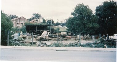 Ringwood and District Historical Society
4 Coloured photographs numbered 10043 to 10046, Demolition of buildings in Adelaide Street -Ringwood. Circa 1960
... East side of Adelaide Street- Ringwood Mail Office and Pines..." Demolition of buildings East side of Adelaide Street- Ringwood Mail ...Postcard size coloured photograph"Written on back of photograph" Demolition of buildings East side of Adelaide Street- Ringwood Mail Office and Pines Hospital in background. Early 1960's -
Glenelg Shire Council Cultural Collection
Photograph - Photograph - Main Breakwater construction, Portland, 13/07/1953
... 13/7/57 Main Breakwater East Side... 13/7/57 Main Breakwater East Side Black & white photo of main ...Port of Portland Authority ArchivesBack: Purple PHT Stamp Print No. 4/8 Neg No 160 Date Taken 13/7/57 Main Breakwater East Sideport of portland archives, harbour, portland, construction -
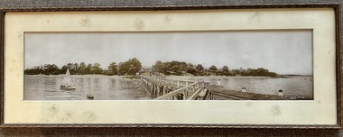 Phillip Island and District Historical Society Inc.
Photograph, Framed Panorama Cowes Jetty & Booklet, Prior to 1938
... , based on the existence of a small shed on the east side... on the east side of the jetty. Historical Panorama Cowes Jetty ...Neil Robinson believes the photo was taken prior to 1938, based on the existence of a small shed on the east side of the jetty.HistoricalFramed Panorama of Cowes Jetty taken from the jetty showing the jetty shed, Isle of Wight hotel and other Cowes buildings. Photo is lightly coloured. Plus Booklet - Research Data of Buildings etc. in PanoramaCowes Phillip Island Victoria. The Valentine Publishing CO. PTY.LTD. Melbournepanorama cowes jetty, the isle of wight hotel cowes phillip island, cowes sea baths, bayview house, neil robinson, maggie robinson, george cox -
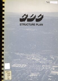 Greensborough Historical Society
Book - Planning Document, TTM Consulting Pty Ltd, Greensborough District Centre: Structure plan, 1989, 1989_07
... of the East side of Main Street Greensborough.... for the development of the East side of Main Street Greensborough ...A summary of investigations into impacts of the Greensborough District Centre in 1989, with plans for the development of the East side of Main Street Greensborough.91 pages text and black and white line drawings. One colour fold out map. Black plastic binding and clear plastic cover. greensborough district centre, main street greensborough, greensborough plaza -
Canterbury History Group
Postcard - Wattle Valley Road
... , looking up the east side of Wattle Valley Road ..., looking up the east side of Wattle Valley Road Canterbury Road ...Early photograph from 267 Canterbury Road Canterbury, looking up the east side of Wattle Valley Road A4 page with B & W photocanterbury road, wattle valley road, canterbury mansions, malone's hotel -
Glenelg Shire Council Cultural Collection
Photograph - Photograph - Main Breakwater construction, Portland, n.d
... Black and white aerial photo, taken from east side of main... east side of main breakwater under construction. Henty Park ...Port of Portland Authority Archivesport of portland archives, harbour construction, development, main breakwater -
Whitehorse Historical Society Inc.
Article, Traders miss foot traffic, 2010
... Activity Centre, which occupies the shopping strip on the east side... the shopping strip on the east side of Springvale Road opposite the new ...Article on the reduction of custom for the Nunawading Activity Centre, which occupies the shopping strip on the east side of Springvale Road opposite the new Nunawading Railway Station, owing to the relocation of the station.Article on the reduction of custom for the Nunawading Activity Centre, which occupies the shopping strip on the east side of Springvale Road opposite the new Nunawading Railway Station, owing to the relocation of the station.Article on the reduction of custom for the Nunawading Activity Centre, which occupies the shopping strip on the east side of Springvale Road opposite the new Nunawading Railway Station, owing to the relocation of the station.nunawading shopping centre, nunawading railway station, nunawading activity centre -
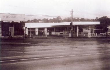 Whitehorse Historical Society Inc.
Photograph, Site of new Nunawading ALDI Store, 1/06/2009
... in Springvale Road, Nunawading on the east side and south of the railway... in Springvale Road, Nunawading on the east side and south of the railway ...Black & white photograph of the site of the proposed new Nunawading ALDI store. The site was the former Caltex Service Station in Springvale Road, Nunawading on the east side and south of the railway line.springvale road nunawading, aldi, caltex service station