Showing 136 items matching "elgar road"
-
 Melbourne Tram Museum
Album - Robert Thomson Slide Collection, AETA Convention 1978 Melbourne
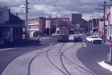
... RT188 East Burwood Elgar Road 26-3-78 RT189 East Burwood... RT188 East Burwood Elgar Road 26-3-78 RT189 East Burwood ...Photo - see pdf file for further information. Number Brief Description RT175 St Kilda Carlisle St - tram 966 - "Kew Cotham Rd" - route 69 RT176 Pantograph W Class RT177 Z Class 91 Preston 28-3-78 - tram 91 - " Northcote Dundas St via High St" RT178 Z Class cars Preston 28-3-78 RT179 Wheel Transport Car 16W "Q" Class Preston 28-3-78 RT180 Z Class 51 Royal Park Res Track 27-3-78 - tram 51 -"Special" RT181 W6 - 990 - Glen Iris Terminus 26-3-78 "City" - route 6 RT182 w7-1007 Elizabeth Street Terminus 24-3-73 "Essendon Airport" - route 59 RT183 Z Class 51 Napier St Siding Essendon 27-3-78 - "City" RT184 Volvo Bus Swanston - Flinders 24-3-78 - "Bulleen via North Kew" - route 202 RT185 W6 - 878 Burwood Old Terminus 26-3-78 - "Spencer St" - route 74 RT186 W6 - 878 Burwood Old Terminus 26-3-78 - "Spencer St" - route 75 RT187 East Burwood Andrews Street 26-3-78 RT188 East Burwood Elgar Road 26-3-78 RT189 East Burwood Reservation Parer Street 26-3-78 RT190 East Burwood Terminus 26-3-78 RT191 East Burwood Terminus 26-3-78 RT192 "6" RT193 "5" RT194 "4" RT195 "3" RT196 "2" RT197 "1" Z Cars under constructionDemonstrates the work of Robert Thomson in photography, collection and/or production of slidesAssembled album in a black presentation folder of 23 colour slides, collected or produced by Robert Thomson. All photographs have been scanned and placed on the Museum's G drive. A list of all photographs with details has been compiled. melbourne, tramways, trams -
 Surrey Hills Historical Society Collection
Photograph, Subdivision sale of Black's Mont Albert farm in 1924, 1924
... to near Elgar Road. It was subdivided into 88 house allotments... of Hamilton Street to near Elgar Road. It was subdivided into 88 house ...Photo was taken in 1924 when the land was subdivided. Black's dairy farm occupied the area just east of Hamilton Street to near Elgar Road. It was subdivided into 88 house allotments along Churchill Street, Bruce Street, Black Street, Proudfoot Street and View Street. The solicitors were Proudfoot & Horton, 360 Collins Street; estate agents were Duncan & Weller, 29 Queen Street. The real estate subdivision notice on the SLV website states that Neil Black had been the owner for 50 years. To date no trace of a Neil Black has been found. Box Hill rate books simply give BLACK as the owner in 1877 (no first name); the entry for 1878-1884 states Robert Black. The 1909 electoral roll has entries for Mont Albert Road for Robert Black (farmer), Thomas Black (carter) & Elizabeth Black (HD). The 1912 electoral roll has entries for Mont Albert Road for Robert Black (farmer), Thomas Black (labourer), John Arthur Black (carter) & Elizabeth Black (HD). Robert Black died in 1920 (b. 1836) and is buried in Box Hill Cemetery (CE-*-0057). His parents were John and Margaret Black. He married Lizzie Foley in 1878. She was the daughter of Margaret & John Foley, born in 1859. She died in 1902 aged 43 years and is buried in the same grave, although the cemetery records record her age as 0 years (presumably as no age or date of birth were given at the time of burial). Children: 1. James Hughbert (1880-1954) 2. John Arthur (1881-1959) 3. Alice (1882-1883) - died aged 6 months 4. Laura Elizabeth (1883-1951) 5. Thomas (1885-1965) 6. Isabella (1887-1963) 7. Eleanor (1889-1963) 8. Ada Maud (1890-1968) 9. Robert (1892-1930). BDM Victoria states places of birth as Box Hill, Surrey Hills or Mont Albert. Many of the family are buried in Box Hill Cemetery. None of the girls appear to have married. Communication from a descendant of John Arthur Black gives the following: "John Arthur Black, son of Robert & Lizzie Foley, married Gladys Anne Layton had 4 children, Robert, Elenore, Marion (Follett) & Annie; they had farm on Stud Road, Dandenong where they milked 30 cows that he retired to after being a earth-moving contractor with draft horses and dug irrigation ditches around Shepparton." This is important as documentation of the area's transformation from farming land to residential land use.Black and white photo of a large 3-poled tent in an area of flat land with eucalypts in the background. There is a large crowd of people, mainly men but also women and children. There are also 3 cars to the RHS.black's dairy farm, dairying, farms, churchill street, black street, proudfoot street, bruce street, view street, neil black, proudfoot & horton, duncan & weller, robert black, lizzie black, lizzie foley, james hubert black, john arthur black, alice black, laura elizabeth black, thomas black, isabella black, eleanor black, ada maud black, robert black jnr, box hill cemetery, land sales -
 Surrey Hills Historical Society Collection
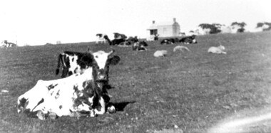
Photograph, Norman Carter, Part of Black's dairy farm in Mont Albert in the 1920s, 1920s
... east of Hamilton Street to near Elgar Road. It was subdivided... occupied the area just east of Hamilton Street to near Elgar Road ...Photo is likely to have been taken pre-1924 when the land was subdivided. Donor information is that this was taken from a home in Churchill Street, Mont Albert; it would be looking south towards Mont Albert Road. Black's dairy farm occupied the area just east of Hamilton Street to near Elgar Road. It was subdivided into 88 house allotments along Churchill Street, Bruce Street, Black Street, Proudfoot Street and View Street. The solicitors were Proudfoot & Horton, 360 Collins Street; estate agents were Duncan & Weller, 29 Queen Street. The real estate subdivision notice on the SLV website states that Neil Black had been the owner for 50 years. To date no trace of a Neil Black has been found. Box Hill rate books simply give BLACK as the owner in 1877 (no first name); the entry for 1878-1884 states Robert Black. The 1909 electoral roll has entries for Mont Albert Road for Robert Black (farmer), Thomas Black (carter) & Elizabeth Black (HD). The 1912 electoral roll has entries for Mont Albert Road for Robert Black (farmer), Thomas Black (labourer), John Arthur Black (carter) & Elizabeth Black (HD). Robert Black died in 1920 (b. 1836) and is buried in Box Hill Cemetery (CE-*-0057). His parents were John and Margaret Black. He married Lizzie Foley in 1878. She was the daughter of Margaret & John Foley, born in 1859. She died in 1902 aged 43 years and is probably buried in the same grave, although the cemetery records record her age as 0 years. Children: 1. James Hughbert (1880-1954) 2. John Arthur (1881-1959) 3. Alice (1882-1883) - died aged 6 months 4. Laura Elizabeth (1883-1951) 5. Thomas (1885-1965) 6. Isabella (1887-1963) 7. Eleanor (1889-1963) 8. Ada Maud (1890-1968) 9. Robert (1892-1930). BDM Victoria states places of birth as Box Hill, Surrey Hills or Mont Albert. Many of the family are buried in Box Hill Cemetery. None of the girls appear to have married. Communication from a descendant of John Arthur Black gives the following: "John Arthur Black, son of Robert & Lizzie Foley, married Gladys Anne Layton had 4 children, Robert, Elenore, Marion (Follett) & Annie; they had farm on Stud Road, Dandenong where they milked 30 cows that he retired to after being a earth-moving contractor with draft horses and dug irrigation ditches around Shepparton." This is important as documentation of the area's early farming land use.Black and white photo of a paddock with cows and sheep grazing. On the horizon is a simple cottage with a small veranda and 2 chimneys and scattered trees.black's dairy farm, dairying, farms, churchill street, black street, proudfoot street, bruce street, view street, neil black, proudfoot & horton, duncan & weller, robert black, lizzie black, lizzie foley, james hubert black, john arthur black, alice black, laura elizabeth black, thomas black, isabella black, eleanor black, ada maud black, robert black jnr, box hill cemetery -
 Melbourne Tram Museum
Ephemera - Timetable, The Met, Set of 12 Tram Timetables, produced by The Met, 1987 - 1989
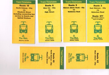
... Road - 14/9/1987 .11- Route 70 - Wattle Park (Elgar Road... 70 - Wattle Park (Elgar Road) Princes Bridge via Swan St - 31 ...Set of 12 Tram Timetables, produced by The Met for various routes, yellow cover with a green top band, multi fold horizontal sheet, giving a route map, description, notes, time points, information contact details and types of tickets (Neighbourhood and Travelcards) and where they could be purchased. .1 - Route 3 - East Malvern - City via Balaclava Road - replaced by bus 377 on Sundays - dated 14/9/1987 .2 - Route 5 - Malvern Burke Road - City via Wattletree Road - 19/6/1988 .3 - Route 6 - Glen Iris - City via High St - 19/6/1988 .4 - Route 19 - North Coburg - City via Elizabeth St including connecting bus service to Gowrie and Upfield stations - 14/11/1988 .5 - Route 42 - Mont Albert - City - 15/8/1988 .6 - Route 48 - North Balwyn - City via Flinders St - 31/10/1988 .7 - Route 55 - West Coburg - Domain Interchange via William St - 11/2/1987 .8 - Route 57 - West Maribyrnong - City via North Melbourne - Route 357 bus replaces tram on Sunday - 27/8/1989 .9 - Route 59 - Airport West - City via Essendon - 27/8/1989 .10 - Route 64 - East Brighton - City via Hawthorn Road - 14/9/1987 .11- Route 70 - Wattle Park (Elgar Road) Princes Bridge via Swan St - 31/10/1988 .12 - Route 86 - Bundoora - City via West Preston - 15/8/1988 Full Image of .4 added 9/4/17 following a query about route 19 timetables - see image i5.trams, tramways, timetables, tickets, tram services, route 3, route 5, route 6, route 19, route 42, route 48, route 55, route 57, route 59, route 64, route 70, route 86 -
 Surrey Hills Historical Society Collection
Photograph, Yielima, 31 Erasmus Street, Surrey Hills
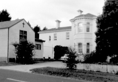
... Balwyn on a daily basis, the property at 301 Elgar Road... Balwyn on a daily basis, the property at 301 Elgar Road ...Known as ‘Yielima’ 1888-1922 and ‘St. Aubins’ 1922-1956, this ‘modernized’ mansion was built about 1887 for Edward Kellett. He was born in Chorley, Lancashire, England. Edward Kellett married Selina Wells in 1852 at St Peters, Eastern Hill. She was born in c1827 in Aston Clinton, Buckinghamshire, daughter of William Wells and Elizabeth Allan. The family arrived from Aylesbury, Buckinghamshire on the 'Osprey' on 22 March 1849. The couple had 8 children - 5 girls and 3 boys; 3 died in infancy. All were born in Collingwood before the family came to Surrey Hills. Edward's funeral notice in The Argus of 11 July 1893 states that he was a corn merchant of Exhibition Street. His property was sworn at 1512 pounds, 1232 in realty and 280 pounds personally. He was buried in Melbourne General Cemetery (CofE Compartment K, No 306). Selina is listed in Erasmus Street in the 1903, 1905 and 1908 electoral rolls as a boarding house keeper. She died at Surrey Hills on 22/10/1911. In her will she left realty valued at 900 pounds and personally at 220 pounds. She was buried with her husband. 'Yielima' was sold on 19 Febraury 1919 with a sale of contents on 18 March 1919. From 1922-1947 Thomas Daniel O’Callaghan (c1871-1962), a police magistrate, made his home here. He is remembered as being of ‘soldierly demeanour, with a flowing mane of hair’. He always carried a walking stick and wore a flower in his buttonhole. His wife was Florence (nee Harling, c1873-1933) pre-deceased him. They had previously lived in Essendon, Moonee Ponds and Stawell before coming to Erasmus Street. After moving out of Erasmus Street he is listed in the 1949 and 1954 electoral rolls at 90 Durham Road, Surrey Hills. In 1952 the property was purchased by Father Timothy Fitzpatrick, Parish Priest of Our Holy Redeemer Parish, Surrey Hills. It consisted of a large two storey house, a coach house and stable, and an acre and a half of land. In 1954 the coach house and stable were converted into the Church of Our Lady of Perpetual Succour and the following year Father John Kelly was appointed parish priest. and resided in the house. At this time the house was not in good repair. "The gentleman who had lived there alone since his wife died many years before, lived in the servants quarters and the rest of the house had been badly neglected. (REF: https://ourholyredeemer.cam.org.au/history) At the beginning of 1957 the Missionary Sisters of the Sacred Heart opened a school next door. As they travelled from Balwyn on a daily basis, the property at 301 Elgar Road was purchased as a presbytery and 'Yielima' became a convent. The stables continued to be used as a church until 1964 when a new church was completed and opened by His Grace Archbishop Simmonds on the 20th of March. There were never large numbers of double-storey Victorian mansions in Surrey Hills. 'Yielma' is significant as one of the few remaining ones. It is also significant for its association with the Catholic Church.A black and white photograph of an Italianate style home with a weatherboard building with a cross on it in front of the main building and to the left of the photograph. There are some well established trees in the garden, a car parked in the parking area and a picket fence along the front.yielima, st aubins, house names, erasmus street, surrey hills, 1887, (mr) edward kellett, (mr) thomas daniel o'callaghan, corn merchant, police, italianate style, wattle park roman catholic church, (mrs) florence o'callaghan, mrs selina kellett, miss selina wells, convent, presbytery, our lady of perpetual succour -
 Whitehorse Historical Society Inc.
Pamphlet, Introducing WERA, 1995
Introducing WERA - pamphlet on the organisations aims.Introducing WERA - pamphlet on the organisations aims, asking for new members for a new association: 'West of Elgar Residents Association'.Introducing WERA - pamphlet on the organisations aims.clubs and associations, west of elgar residents association, anderson, richard, scheiber, robert, kavanagh, june -
Whitehorse Historical Society Inc.
Map, Aerial maps, 2/04/1966 12:00:00 AM
Melbourne 1966 project, runs 10A and 11A, lens 122 151.75 mm 9,800. Photo nos 77, 107, 109, 161, 163, 165.Melbourne 1966 project, runs 10A and 11A, lens 122 151.75 mm 9,800. Photo nos 77, 107, 109, 161, 163, 165. Areas and boundaries: Map no 77 W. Park and Cook Roads; E. Dubon Rd; N Oban Rd; S Reilly St. Map No 107. W. Indra Rd and Pakenham St; E. Rooks Rd & McLares Rd; N. Maroondah Hwy; S. Hawthorn Rd & Eley Rd. Map No 109 W. Elgar Rd. E. Blackburn Rd & McKean St; S. Eley Rd & Burwood Hwy. Map No 161. W. Elgar Rd & Huntingdale Rd; E. Blackburn Rd; N. Burwood Hwy; S. Waverley Rd. Map No 163. W. Blackburn Rd; S. Springvale Rd; N. Eley Rd & Hawthorn Rd; S. Glen Waverley Railway Line. Map No 165. W. Stanley Rd, Vermont South; E. Cathies Lane, Wantirna South; N. North of Burwood Hwy; S. High Street. Melbourne 1966 project, runs 10A and 11A, lens 122 151.75 mm 9,800. Photo nos 77, 107, 109, 161, 163, 165. aerial photographs, blackburn, blackburn south, forest hill, nunawading, box hill, burwood, burwood east, donvale, mount waverley, glen waverley, wantirna, vermont south, mitcham, ringwood north, ringwood -
Whitehorse Historical Society Inc.
Map, Parishes of Bulleen, Boroondara, Prahran and Nunawading, 1850
Photocopy of map and tables of corners of allotments.Photocopy of map and tables of corners of allotments. Note on verso: Nunawading, Boroondara, Prahran. Allotments in the Parish surveyed by Lindsay Clarke 1850 (note by Robert Hoddle, surveys by Unwin, Elgar and Dendy indicated)Photocopy of map and tables of corners of allotments. maps, parish of bulleen, parish of boroondara, parish of prahran, parish of nunawading, clarke, lindsay, hoddle, robert -
Whitehorse Historical Society Inc.
Map, Plan of special survey selected by H. Elgar Esq, 1841
Photocopy of plan and listing of corner stakes.Photocopy of plan and listing of corner stakes. Note on verso: Plan of special survey selected by H. Elgar Esq in the Parishes of Boroondara and Nunawading, County of Bourke. Surveyed by T.H. Nott (?Sydney) 31 May 1841. Boroondara Special Survey B.17, with attached descriptive note by T. H. Nott.Photocopy of plan and listing of corner stakes. maps, parish of boroondara, parish of nunawading, elgar, h, nott, t.h. -
 Whitehorse Historical Society Inc.
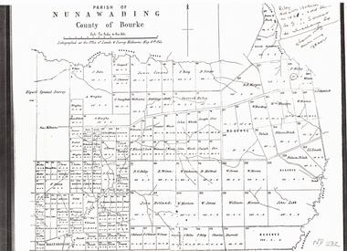
Document, Plan of Parish of Nunawading, 01/05/1864
Copy of plan of Parish of NunawadingCopy of plan of Parish of Nunawading, County of Bourke, lithographed at the Office of Lands and Survey, Melbourne, 13th May, 1864 showing boundaries of Koonung, Mullum Mullum and Dandenong Creeks.Copy of plan of Parish of Nunawadingland subdivision, parish of nunawading, county of bourke, elgars special survey, koonung creek, mullum mullum creek, dandenong creek -
 Whitehorse Historical Society Inc.
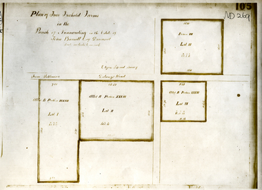
Document, Parish of Nunawading
... Whitehorse Historical Society Inc. 2-10 Deep Creek Road ...Plan of four farms in the estate of John BarrattPlan of four farms in the estate of John Barratt on Delaneys RoadPlan of four farms in the estate of John Barratt parish of nunawading, barratt, john, delaney's road, ringwood north, elgars special survey, land subdivision -
 Whitehorse Historical Society Inc.
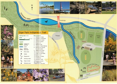
Pamphlet, Elgar Park Indigenous Trail
Pamphlet prepared by Greenlink Box Hill IncPamphlet prepared by Greenlink Box Hill Inc. about Elgar Park Indigenous Trail, Box Hill and Bushy Creek Indigenous Trail, Box HillPamphlet prepared by Greenlink Box Hill Incparks and reserves, elgar park indigenous trail, bushy creek reserve, greenlink box hill inc -
Whitehorse Historical Society Inc.
Document, Bridge divides locals, 2010
Report of proposal by Deakin University, Burwood Campus to construct a 200m. bridge over Gardiners Creek to connect two portions of its campus, and comments from West Elgar Residents Association spokeswoman.Report of proposal by Deakin University, Burwood Campus to construct a 200m. bridge over Gardiners Creek to connect two portions of its campus, and comments from West Elgar Residents Association spokeswoman.Report of proposal by Deakin University, Burwood Campus to construct a 200m. bridge over Gardiners Creek to connect two portions of its campus, and comments from West Elgar Residents Association spokeswoman.west of elgar residents association, gardiners creek, deakin university. burwood campus -
Whitehorse Historical Society Inc.
Article, Uni Bridge battle begins, 2015
For more than a decade, Deakin University has tried to have a bridge built across Gardiners Creek Reserve to link its two campuses.For more than a decade, Deakin University has tried to have a bridge built across Gardiners Creek Reserve to link its two campuses.For more than a decade, Deakin University has tried to have a bridge built across Gardiners Creek Reserve to link its two campuses.city of whitehorse, deakin university, burwood campus, west of elgar residents' association, gardiners creek reserve -
Whitehorse Historical Society Inc.
Document, Set to tackle top job, 2008
Elgar Ward Councillor and Greens member Helen Harris, who was elected as Mayor of Whitehorse, is set to tackle planning issues, climate change and their effects of financial meltdown.Elgar Ward Councillor and Greens member Helen Harris, who was elected as Mayor of Whitehorse, is set to tackle planning issues, climate change and their effects of financial meltdown.Elgar Ward Councillor and Greens member Helen Harris, who was elected as Mayor of Whitehorse, is set to tackle planning issues, climate change and their effects of financial meltdown.harris, helen, city of whitehorse -
 Whitehorse Historical Society Inc.
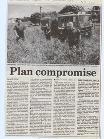
Article, Plan compromise, 12/11/1997 12:00:00 AM
Whitehorse Council has reached a compromise in draft strategyWhitehorse Council has reached a compromise in draft strategy for fire management in bushland reserves.Whitehorse Council has reached a compromise in draft strategy antonio park, mitcham, bellbird dell, blackburn lake sanctuary, yarran dheran, abbey walk, vermont, blacks walk, cootamundra walk, elgar park, heatherdale reserve, stephens reserve, mullum mullum creek, furness park, campbells croft, gardiners creek, surrey park, memorial park, somers trail -
 Whitehorse Historical Society Inc.
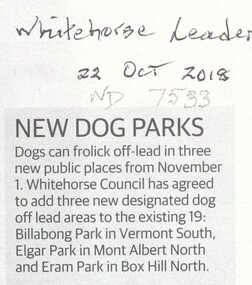
Article, New Dog Parks
Dogs can frolic off-lead in three new public places from 1 Nov 2018 bring the total to 22 places.Dogs can frolic off-lead in three new public places from 1 Nov 2018 bring the total to 22 places. The three new ones are Billabong Park, South Vermont; Elgar Park, Mont Albert & Erarn Park, Box Hill North.Dogs can frolic off-lead in three new public places from 1 Nov 2018 bring the total to 22 places. dogs, city of whitehorse, billabong park, vermont south -
 Whitehorse Historical Society Inc.
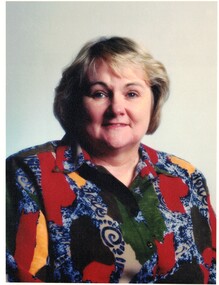
Photograph, McCallum Jessie - Councillor
... Whitehorse Historical Society Inc. 2-10 Deep Creek Road ...Elgar Ward City of Nunawading.Coloured photograph of Jessie McCallum Wearing multi coloured blouse. Short blond hair.jessie mccallum, councillor - nunawading and whitehorse8whitehorse council -
 Surrey Hills Historical Society Collection
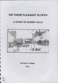
Book, On these pleasant slope's: a story of Surrey Hills, 2015
Sourced via conversations with those interested in Surrey Hills History. Including Alan Holt, Jack McLean, Frank Bamford, Jocelyn Hall. Includes: Topographical maps, first Elgar Survey. First Wesleyan Church in Surrey Hills. Bibliography on P.50 (last numbered page) Provides a chronological history of Surrey Hills. Includes: First settlers, location, early land sales, commerce and trade.Provides a chronological history of Surrey Hills. Includes: First settlers, location, early land sales, commerce and trade.Back of Title page: To the Surrey Hills Historical / Arthur E. Tonkinfreehold investment and banking company, windsor park estate, (mr) dennis delany, mont albert village, surrey hills - history, royal hotel, surrey hills, humberstone's hotel, chatham state school, holy trinity church, lydswood, lugano, (mr) john butler maling, (mr) john hanlon knipe, mont albert primary school, (mr) james sneddon, (mr) arthur tonkin -
 Surrey Hills Historical Society Collection
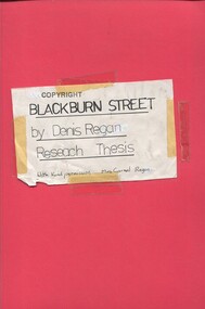
Book, Blackburn Street, ?1980s
A thesis prepared by Mr Denis Regan for a Home and Environment Study, on Surrey Hills, Blackburn Street, and in particular no. 3 Blackburn Street, built in 1920. Includes some photos and house prices.A thesis prepared by Mr Denis Regan for a Home and Environment Study, on Surrey Hills, Blackburn Street, and in particular no. 3 Blackburn Street, built in 1920. Includes some photos and house prices.surrey hills, blackburn street, (mr) denis regan, blackburn estate, elgar's special survey, (mr) fred hemingway oldis, houses, californian bungalow, (mr) william holland, house names, clevedon, (mrs) christina holland, (mrs) carmel regan, (mr) len lewis, (mrs) doreen lewis -
 Surrey Hills Historical Society Collection
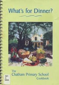
Book, What's for dinner? The Chatham Primary School Cook book, Nov 1999
The book was edited by Clare Nicholls (Coney) and the photo on the front cover shows a view of her then home 'Monserrat' at 26A Wandsworth Road, Surrey Hills. Silky Swallow was a Chinese restaurant at 369/371 Mont Albert Road, Mont Albert. Wild Flower was located at 1 Theatre Place, Canterbury. It was established in c1993 and until 2004 was BYO. Chef's Tandoor is located at It was established in 1991 by Mr Virender Bist (Owner/Chef) who had been head chef with the Taj Group of Hotels. Bollywood on the park is located at 156 Elgar Rd, Box Hill South, opposite Wattle Park. A community cook book with recipes for every occasion. It includes recipes contributed by staff and families plus special recipes from local restaurants and celebrities.chatham primary school, cook book, chef's tandoor, bollywood on the park, wildflower restaurant, silky swallow restaurant, monserrat -
 Surrey Hills Historical Society Collection
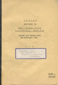
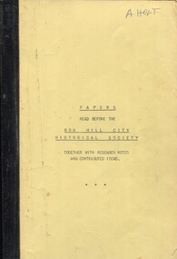
Book, Papers read before the Box Hill Historical Society: together with research notes and contributed items, Vol. I 1964-68, 1968
A collection of papers presented at meetings of the Box Hill Historical Society detailing hsitory of local families, churches, schools and other significant histories.A collection of papers presented at meetings of the Box Hill Historical Society detailing history of local families, churches, schools and other significant histories."F. N. Bamford" on title pagebox hill, elgar's special survey, ballyshanassy, aspinall family, sutton family, box hill cemetery, 1964, 1968, schools, ormiston girls' school, talbett family, britnell family, bedford family -
 Surrey Hills Historical Society Collection
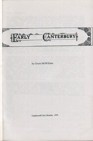
Book, Early Canterbury, 1994
This booklet gives a brief description of the local settlement in Canterbury giving the landholders names and name of the house (before street numbering was introduced) and street it was located in.This booklet gives a brief description of the local settlement in Canterbury giving the landholders names and name of the house (before street numbering was introduced) and street it was located in.canterbury, (ms) jane f portingale, postmistress, (mr) arundel wrighte, wood brothers, koonung creek, (mr) thomas power, (mr) oliver russell, (mr) frederick griffin, (mr) thomas payne, shrublands, w creek, (mr) john gardiner, (mr) james shanley, (mr)robert hoddle, (mr) michael logan, (mr) patrick moloney, (mr) hugh glass, r. larkins, t. hassett, e. sturt, d.s. campbell, (mr) joseph camm, riversdale road, w. logan, rochester road, 1843, trees, mont albert road, a. sikes, (mr) william smith, 1853, (mr) ernest carter, dentist, elgar's surrey, hindson family, (mr) george granville mercy, (mr) alfred golding, (mr)alexander patterson, (mr) thomas boanas, (mr) thomas hyde, builders, (mr) richard terrill, architects, (mr) thomas miles, drapers -
 Surrey Hills Historical Society Collection
Book, Box Hill Historical Society, Papers read before the Box Hill Historical Society: together with research notes and contributed items, Vol. I 1964-68, 1968
A collection of papers presented at meetings of the Box Hill Historical Society detailing hsitory of local families, churches, schools and other significant histories."F. N. Bamford" on title pagebox hill, elgar's special survey, ballyshanassy, aspinall family, sutton family, box hill cemetery, 1964, 1968, schools, ormiston girls' school, talbett family, britnell family, bedford family -
Canterbury History Group
Document - School Project: A history of 137 Mont Albert Road, Canterbury, Rush, Anne-Marie
... Canterbury History Group 190A Canterbury Road Canterbury ...A research paper for the Australian History option describing the history of 137 Mont Albert Road, Canterbury. The writer looks at the lives of various owners, particularly Henry Elgar and Richard Quittenton, and how the house has changed since it was built in 1890. includes 2 pages of plans of Elgar's Special Surveycanterbury, mont albert road, "haslemere", quittenton> richard, elgar> henry, elgar's special survey, boroondara estate -
Canterbury History Group
Document - School Project: Elgar's Special Survey, Tudehope, Jennifer, 1963
... Canterbury History Group 190A Canterbury Road Canterbury ...Well researched essay on the background of Elgar's Special Survey. Includes mapcanterbury, elgar> henry t., land surveys, boroondara, campbell> j & r, dacre> r, towns> r., sea> h., dyce> a., mccarthy> w.g., shenley> james, henty's paddock, norris> j.r., maling> j, canterbury road, survey road, boroondara roads board, camberwell historical society, mont albert road, brooks> r., land subdivisions -
Canterbury History Group
Document - Elgar's Special Survey, part of, 1990
... Road and Faversham Road Canterbury Document Elgar's Special ...Photocopy of part of Elgar's Special Survey relating to the area between Mont Albert Road, Rochester Road and Faversham Road Canterburycanterbury, mont albert road, rochester road, faversham road, elgar's special survey, creeks -
Canterbury History Group
Document - Early subdivision of the Canterbury area, Noble, Gerry, 1988
List of the early purchasers of the building blocks resulting from subdivision in Canterburycanterbury, land subdivision, elgar's special survey, campbell> robert, dacre> ranulph -
Canterbury History Group
Photograph - Elgar's Special Survey, unknown
... melbourne Elgar's Special Survey Canterbury Canterbury Road ...A photograph of part of Elgar's Special Survey showing owners of property for mostly Canterbury in 1850elgar's special survey, canterbury, canterbury road, riversdale road, burke road, prospect hill road, wattle valley road -
Canterbury History Group
Pamphlet - "Coorinyah", 150 Mont Albert Road, Canterbury, c2001
... melbourne Canterbury Mont Albert Road Coorinyah Elgar's Special ...Real estate pamphlet for the sale of "Coorinyah" 150 Mont Albert Road, Canterbury, includes two extra pages giving description and history of the property and coloured photographs of the interior and exterior.canterbury, mont albert road, coorinyah, elgar's special survey, great railway estate, mellor family, best> sir robert, ussher> beverley