Showing 494 items matching "foreshores"
-
 Phillip Island and District Historical Society Inc.
Sepia Photograph, 1920's
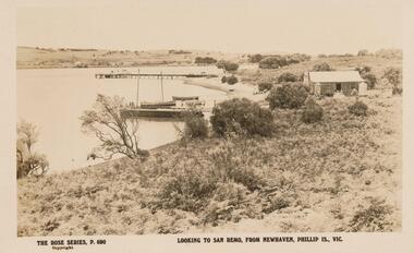
This album was presented to the Earl of Stradbroke by the Fathers of Soldiers and Returned Soldiers 16/02/1923. Photo of San Remo taken from Newhaven.Photograph of Newhaven pier with fishing boats in foreground looking across to San Remo. A small residence quite close to foreshore.Rose Series P690. San Remo Newhavenphillip island, newhaven, san remo, earl of stradbroke -
 Phillip Island and District Historical Society Inc.
Photograph
One of a collection of over 400 photographs in an album commenced in 1960 and presented to the Phillip Island & Westernport Historical Society by the Shire of Phillip IslandPhotograph of Phillip Island Suspension Bridge taken from Newhaven foreshore with Ti-tree foreground, San Remo background.local history, photography, photographs, bridges, phillip island bridge, black & white photograph, phillip island suspension bridge, san remo, newhaven, john jenner, bryant west -
 Lakes Entrance Historical Society
Book, Department of Conservation and Environment, Lake Tyers Foreshore Reserves Management Plan, 1991
An approved management plan relating to the public foreshore land between Lake Bunga and Mill Point. Contains plans and appendices.waterfront, vegetation -
 Chelsea & District Historical Society Inc
Photograph - Edithvale Life-Saving Club, 1940's-1950's
Edithvale Life Saving Club was founded in 1919.Black and white postcard of Edithvale Life-Saving Club, a double story wooden building, built on the foreshore of Edithvale beach.Tainsh Series No 1 The Beach Edithvale Printed on back: A real photograph. Produced in Australia Handwritten on back: 4th July 1942, Edithvalelife saving club, edithvale, edithvale beach -
 St Kilda Historical Society
Photograph, St Kilda Foreshore, c. 1950
Early work on St Kilda Foreshore.black and white photograph, original, poor condition, unmounted -
 Phillip Island and District Historical Society Inc.
Photograph, 1910
One of a collection of over 400 photographs in an album commenced in 1960 and presented to the Phillip Island & Westernport Historical Society by the Shire of Phillip IslandPhotograph of San Remo looking south along the foreshore showing some houses. Reef exposed by low tide. Jetty in background.local history, photography, photographs, san remo and foreshore, sepia photograph, san remo, foreshore, jetty, john jenner, bryant west -
Glenelg Shire Council Cultural Collection
Photograph - Photograph - Portland Harbour, 1958
Port of Portland Authority ArchivesBack: "L - R" - top left pencil. Purple Stamp - TOP RIGHT "17 Nov 1958"port of portland archives, portland harbour, bentinck street, all saints, foreshore, 1958 -
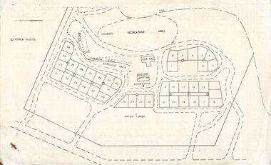 Bendigo Historical Society Inc.
Document - STATE RIVERS AND WATER SUPPLY COMMISSION : EPPALOCK RECREATIONAL AREA PLAN?
Photocopied plan of power points for a recreational area, possibly Eppalock foreshore recreational area?. No title, and undated. With other Eppalock documents.state infrastructure, water supply, coliban system, state rivers and water supply commission. coliban system. eppalock. -
Port Melbourne Historical & Preservation Society
Print - Sandridge Foreshore, H Gritten, c. 1865
Black and white lasercopy from the watercolour drawing in the La Trobe Collection, State Library of Victoria of the 1865 watercolour of the Sandridge foreshorebuilt environment -
 Port Melbourne Historical & Preservation Society
Photograph - Princes Pier, Port Melbourne, Charles Pont, 1920s
Tiny snapshot looking down onto Princes Pier and toward the foreshore 1920s, one of several that once belonged to Charles PONT'Princes Pier'piers and wharves - princes pier -
Port Melbourne Historical & Preservation Society
Photograph - Various port scenes, 1980s - 1990s
Looking towards Princes Pier during bicentenary celebrations. Appears to be a ferris wheel on foreshore. Leading light (beacon) is centre of image.piers and wharves - webb dock, piers and wharves - station pier -
Port Melbourne Historical & Preservation Society
Photograph - Concrete beach wall, Port Melbourne, Lyn Allison, Nov 1992
From a series of photos taken by Lyn Allison, then a Councillor of the City of Port Melbourne, to record the condition of Port Melbourne's beachesLasercopy of photo of concrete beach wall on the Port Melbourne foreshore, looking east. Taken by Cr Lyn Allison, Nov 1992.'Nov 92'built environment - civic, natural environment - beaches and foreshore, lyn allison -
Port Melbourne Historical & Preservation Society
Photograph - Port Melbourne foreshore, Lyn Allison, Nov 1992
From a series of photos taken by Lyn Allison, then a Councillor of the City of Port Melbourne, to record the condition of Port Melbourne's beachesLasercopy of photo of Port Melbourne foreshore, looking west toward Station Pier. Taken by Cr Lyn Allison, Nov 1992.'Nov 92'built environment - civic, natural environment - beaches and foreshore, lyn allison -
Port Melbourne Historical & Preservation Society
Photograph - Port Melbourne foreshore from the Bay, David Thompson, 8 Mar 1993
Colour photo of Port Melbourne foreshore prior to demolitions, shot from the Bay with long lens, showing the Melbourne skyline 8.3.1993Details on back in inkbuilt environment -
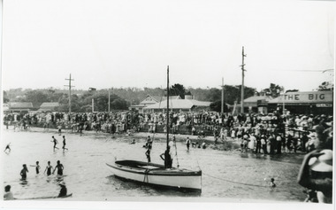 Lakes Entrance Historical Society
Photograph, 1935 c
Black and white photograph of crowd of spectators on Esplanade foreshore watching swimming sports, sailing boat in foreground. Lakes Entrance VictoriaOn reverse - 'Orig L Argent Neg 18A-19 Proof sheet 1'recreation, sports, people -
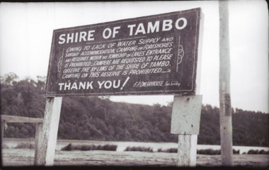 Lakes Entrance Historical Society
Photograph - Tambo Shire Signage re Camping, 1950 c
Black and white photographs of signs on foreshore Marine Parade prohibiting camping other than at authorized parks in Lakes Entrance Victoria tourism, camping, regulations -
 Lakes Entrance Historical Society
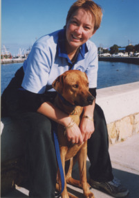
Photograph - RSPCA, Lakes Post Newspaper, 2000
number in album 03510.05Colour photograph RSPCA fundraising Million Paws Walk along Esplanade foreshore, Anna with dog Joan. Lakes Entrance Victoriaanimals, rspca, fundraising -
 City of Kingston
Photograph - Digital image, Colour, City of Kingston (Graham Whitehead)
Colour image of Mentone foreshore looking towards Mordialloc. The natural environment of Kingston significantly impacted its development. The bay was a source of food and income, as well as a holiday destination. Colour image of Mentone beach looking towards Mordialloc, with Mentone life saving club in distance.mentone, beach, environment -
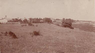
 Phillip Island and District Historical Society Inc.
Photograph, The Esplanade, Cowes, Circa early 20th century
Black & white photo of foreshore area of Cowes with views of Westernport Bay, large pine trees,wooden fence and old tourer car.Esplanade, Cowes handwritten on verso.cowes, photographs, esplanade cowes -
 Phillip Island and District Historical Society Inc.
Photograph, 1939-40
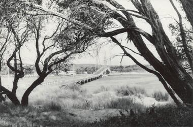
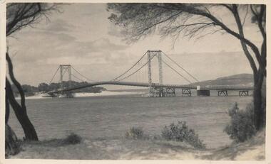
Part of Miss Edith Elms' collection presented via Chrisy Northcote. Shows 1st bridge between Phillip Island and San Remo. Built 1949/1940View of Suspension Bridge taken from Newhaven foreshore framed by tea tree. Shows long, low approach from Phillip Island.local history, photography, photographs, bridges, phillip island, san remo, sepia photograph -
Glenelg Shire Council Cultural Collection
Photograph - Photograph - Portland Harbour and foreshore, n.d
Port of Portland Authority ArchivesBack: Hor line ruled 0.5 cm from top, & 5 cm from bottom 3 (in circle) 51 QMS WIDE + 2 1/2 DOOP 40 x 17 Touch up All pencil 60 in blue pencilport of portland archives, portland harbour, foreshore, bentinck street, henty street, all saints church -
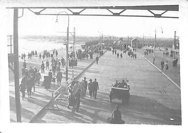
Port Melbourne Historical & Preservation Society
Photograph - Watching the Tall Ships depart, Ron Laing, 1988 - 1999
Part of Ron Laing's collection of photographs recording Port Melbourne over a thirteen year period. Donated to the PMH&PS by the photographer.One of a set of 20 colour photographs 1980s-90s, of various events and subjects . Spectators line the foreshore to watch the departure of the Tall Shipsron laing -
Port Melbourne Historical & Preservation Society
Photograph - Arrival at Port Melbourne, Spirit of Tasmania premier voyage, Devonport to Port Melbourne, David Thompson, 27 Nov 1993
When Mayor Liana Thompson and husband David flew to Devonport and took part in the premier voyage of the new Bass Strait ferry 'Spirit of Tasmania', David took this picture (Ref item 1087, souvenirs of trip)One of 12 photos of the premier voyage of 'Spirit of Tasmania', Devonport to Port Melbourne 27 November 1993: arrival at Port Melbourne; foreshoretransport - ferries, celebrations fetes and exhibitions, spirit of tasmania, abel tasman -
Port Melbourne Historical & Preservation Society
Photograph - SS Nairana, C.1951
The SS Nairana was launched 1915 by William Denny & Brothers in Dumbarton Scotland the 3,402 ton steamer was requisitioned by the Royal Navy and served during WW1. In 1922 she was transferred to Tasmanian Steamers and, apart from again being requisitioned for war service in WW2, was used as a Bass Strait ferry until 1948. The Nairana was blown ashore onto Port Melbourne beach during a severe gale on 19 February 1951. After salvage what remained of the wreck was blown up in 1954. B & W aerial photograph of SS Nairana and Port Melbourne foreshore. Ship's outline can be seen on far right side of photograp.ss nairana, transport - shipping -
Port Melbourne Historical & Preservation Society
Photograph - Electrical sub-station, Foreshore at Station Pier, Viva, 1989
Black and white photo taken 1989 by 'Viva', an artist from the Mission Arts Centre: electrical sub-station on foreshore at Station Pierpiers and wharves - station pier, viva - artist -
 Chelsea & District Historical Society Inc
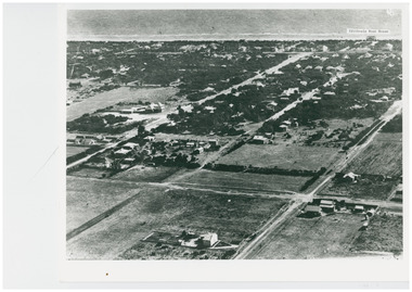
Photograph - Aerial Photo of Edithvale
Edithvale Boat house was opened in 1918. Black and white aerial photo of Edithvale. It shows open paddocks, houses, unmade roads. The Edithvale Boat Shed can be seen on the foreshore. chelsea, aerial photo, edithvale boat house, edithvale -
 Lakes Entrance Historical Society
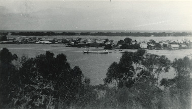
Photograph - Lakes Entrance, 1945 c
The Hulk of the Baang Yarnda on the North Arm foreshore. (Note in album)Black and white photograph showing view from Kalimna cliff overlooking North Arm and township, Cunninghame Arm and sand dunes out to Bass Strait. Hulk of old Baang Yarnda moored in North Arm, towed there in 1939 and left to rot. Thick vegetation in foreground. Lakes Entrance Victoria.township, waterways -
Port Melbourne Historical & Preservation Society
Plan, Graeme Bentley Pty Ltd, Port Melbourne Foreshore Landscape Master Plan MP3 (A), February 1993
The Port Melbourne Foreshore Landscape Master Plan was created by Landscape Architectural firm of Graeme Bentley Pty Ltd for the City of Port Melbourne. MP3 (A) portrays the section of foreshore from Dow Street to Pickles Street. The plan proposed street tree planting along Beach Street and development of a park area opposite Johnson Street. The plan was not actioned.built environment - recreational facilities, beach street, port melbourne foreshore -
Port Melbourne Historical & Preservation Society
Plan, Graeme Bentley Pty Ltd, Port Melbourne Foreshore Landscape Master Plan MP1(A), February 1993
The Port Melbourne Foreshore Landscape Master Plan was created by Landscape Architectural firm of Graeme Bentley Pty Ltd for the City of Port Melbourne. MP1(A) portrays the section of foreshore from the former Port Melbourne Railway Station to Bay Street. The plan proposed extensive tree planting including Tasmanian native trees along Station Pier. The plan was not actioned.built environment - recreational facilities, beach street, port melbourne foreshore, station pier -
 Phillip Island and District Historical Society Inc.
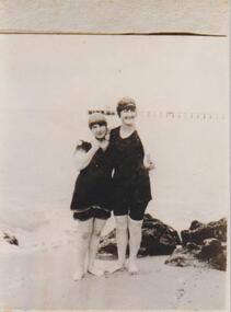
Photograph, Cowes Beach, Phillip Island, 1900's
Beautiful beach very suitable for bathing on Cowes foreshore to left of the Pier.Mother and daughter in neck to knee bathing suits and caps, standing amongst rocks. The pier in the background.local history, photographs, bathers near the pier, phillip island, black & white photograph, betty kus collection, cowes foreshore, jetty, bruce bennett